Churches and Their symbols in the field

Shortstack

Silver Member
Jan 22, 2007
4,305
416
Detector(s) used
Tesoro Bandido II and DeLeon. also a Detector Pro Headhunter Diver, and a Garrett BFO called The Hunter & a Garrett Ace 250.
Primary Interest:
All Treasure Hunting
OP
OP
D

dsty

Bronze Member
Dec 2, 2007
1,300
736
Randal County
It appears that there's interest and we will need all the input from everyone, Tinman! is the brains and I guess you can call me the ole boy sitting in the corner, anyway it was kinda rainy down there so went to work with the computer, started at Spanish fort texas, found out that they are indeed 25 miles apart, not as the crow flies but rather N. S. E. W. We found 7 or 8 using Spanish fort as a reference ( you can do the same thing wherever you may be, just go north and west ) and not only did we find areas there was once a church such as a podium or rock benches, 1" drill holes that went thru the boulder 32" inches, but rather than being vertical they were all horzional and indications are that there was also a cache for the church, also indications were that they had been removed ( old hand dug holes ) found some Good looking egg shaped boulders and we have some opinion's about them also vaults, the church location seems to be in the 25 mile center square Running out of time gotta go
 

Shortstack

Silver Member
Jan 22, 2007
4,305
416
Detector(s) used
Tesoro Bandido II and DeLeon. also a Detector Pro Headhunter Diver, and a Garrett BFO called The Hunter & a Garrett Ace 250.
Primary Interest:
All Treasure Hunting
dsty:
I just sent you an email with a couple of maps you might find interesting. 8-) They're from the early half of the 1700s....maybe earlier.
 

Last edited:
OP
OP
D

dsty

Bronze Member
Dec 2, 2007
1,300
736
Randal County
Hello mdog and SS, thanks for the maps They seem to have 5 squares between compass points which fits wonderful with what I think is going on, Bill the copper mind on Red R. that we talked about in the past turned out to be a vault 6 ft high, in a circular room about 10 feet across, we determined that was where monies was stored for the settlers from new spain, the trail went from the vault to a point 12.5 miles west, then turned south for another 12.5 miles to what the local folks call the Viking baths that been posted in old hand dug holes, seems what we call sections = 1 mile square, their sections were 2.5 miles square, our townships are 36 sections, theirs were 25 leagues square, they had a Place of Worship in the Center with something of value also as did the settlers, information that I believe is correct was 112---- 1 pound bars of oro. The Viking Baths support the information with the Vault and all the other information that's carved at the location. Anyway its really been fun. That's why I feel that its important to find the Old Churches, Easy to locate
 

Shortstack

Silver Member
Jan 22, 2007
4,305
416
Detector(s) used
Tesoro Bandido II and DeLeon. also a Detector Pro Headhunter Diver, and a Garrett BFO called The Hunter & a Garrett Ace 250.
Primary Interest:
All Treasure Hunting
dsty:
That silver mine on that map is described by the French historian who wrote the book the maps were in. I'll copy and past his writings into another email because he gets pretty specific on it's location and the "look" of the ore. I gave this information plus a couple of pounds of topo maps to someone who lives in Louisiana at no cost. I even mailed the maps on my own dime and only asked to be informed if he had any luck finding the place and he never even acknowledged getting the package with the maps. That was a year or 2 ago. Sooooo, I decided not to "sit" on the tip any longer and am passing it to you in case you might know someone in the area. :coffee2:

You know what else is a little surprising? The "Great Rift" on the Red River is not noted on those maps or mentioned in his narrative of his travels in that area. When Captain Shreve took the government contract to clear that thing, the indians in the area all said it had been there for as long as their spoken history went back. Strange.
 

Last edited:
OP
OP
D

dsty

Bronze Member
Dec 2, 2007
1,300
736
Randal County
I know what you are talking about Bill, some folks just don't know how many miles one has traveled, the days / weeks / month / years trying to put the puzzle together and then someone up and says that you don't know what your talking about or water done it, I spent several years in Johnson co ok and most of the time I would walk around the bluff near the Deleware R , so much that I had a trail to follow once I seen 3 large boulders 30 X 30 inches about 15 feet apart that had turned white since I had been there last, I know that lightening storms had gone thru recently and figured what had happened but I always look at white boulders with a raised bit of wonder since then, I seen a turtle head 18 inches long and 10 inches high one eye open one eye squinted , I took it to Stovall Museum at O.U. and that's what they said had happened water done it. I thought that someone had been rolling their own smokes. folklore has it that it was a copper mine Good day to you and thank you Bill. I just wonder if they would put mine on a map to reference a VAULT. Them folks are sneaky. Thanks mdog
 

Last edited:

Shortstack

Silver Member
Jan 22, 2007
4,305
416
Detector(s) used
Tesoro Bandido II and DeLeon. also a Detector Pro Headhunter Diver, and a Garrett BFO called The Hunter & a Garrett Ace 250.
Primary Interest:
All Treasure Hunting
The description of the ore site sounds legitamate and the Portuguese miner who assayed ore there claimed it to be very rich. That isn't to say that a vault of some kind was not build at some point, though. When the Viceroy in Mexico gave the Spanish settlers in the Spanish area of what is now Louisiana, just 2 weeks to move out of the area......lock, stock, and barrel. The soldiers at the Presidio by Mission Las Adias dug a large hole to bury the things they couldn't carry with them. That included a small bronze cannon with a cracked barrel. I found this info during a "cold" search in the library at Centenary and began a file on that cannon. Further research revealed that some men were sent from their new location, just west of the Sabine River, to recover that cannon because they were afraid of the Indian tribes in that area and wanted to wire wrap the barrel and use it for possible defense needs. That ended that particular treasure file, but that whole strip through the central part of Louisiana became know as the Neutral Strip because no country tried to claim it due to uncertainties of ownership. That area was an outlaw's paradise because of NO LAW. That fact opened a lot more thoughts of caches, etc.
 

mdog

Bronze Member
Mar 22, 2011
2,340
4,395
Hello mdog and SS, thanks for the maps They seem to have 5 squares between compass points which fits wonderful with what I think is going on, Bill the copper mind on Red R. that we talked about in the past turned out to be a vault 6 ft high, in a circular room about 10 feet across, we determined that was where monies was stored for the settlers from new spain, the trail went from the vault to a point 12.5 miles west, then turned south for another 12.5 miles to what the local folks call the Viking baths that been posted in old hand dug holes, seems what we call sections = 1 mile square, their sections were 2.5 miles square, our townships are 36 sections, theirs were 25 leagues square, they had a Place of Worship in the Center with something of value also as did the settlers, information that I believe is correct was 112---- 1 pound bars of oro. The Viking Baths support the information with the Vault and all the other information that's carved at the location. Anyway its really been fun. That's why I feel that its important to find the Old Churches, Easy to locate

Hi Dsty,

I've read that there was a shortage of hard money in New France and that French traders would trade with the settlers in New Spain exchanging trade goods for precious metals. Also, there was some contact between the Franciscans in Santa Fe and the Jesuits in New Orleans exploring the possibility of trading silver from New Mexico for the trade goods of New France. Spanish Fort, Texas is at about the halfway point between these two places. Could that explain the vaults?
 

mdog

Bronze Member
Mar 22, 2011
2,340
4,395
Dsty, when did the Spanish set up these surveyed areas? Did they wait until a good area for a post was found and then measure out from there? Eastern Iowa has some lead mines up by Dubuque that were mined during the American Revolution when Spain claimed the land. There was supposed to have been a Spanish settlement further south but so far the archeologists have not had any luck finding it. I would guess that the Spanish would have had a church at a settlement and the place was probably close to the Mississippi. Do you have any hints on how to start a search? St. Louis was also claimed by the Spanish during this period.
 

OP
OP
D

dsty

Bronze Member
Dec 2, 2007
1,300
736
Randal County
Its my opinion that the English done most if not all of the survey work along with the Stone Mason's doing the carving and such, The Jesuit Priest doing the money thing and the Viking's running around hittin folks in the head, the Spanish Military kinda kept things things in order, I think that lots of different folks were involved ( countries a joint venture to speak ) or that's what rolls around upstairs. From what I have seen is that they surveyed everything from the East to West and South to North in 2.5 mile - sections Thanks to SS ( Bill ) who helped me this morning with some good information.
 

Last edited:
OP
OP
D

dsty

Bronze Member
Dec 2, 2007
1,300
736
Randal County
THANK YOU Bill, I will remember that and I will possibly round both distances off to the next number They Fit Wonderful
 

Shortstack

Silver Member
Jan 22, 2007
4,305
416
Detector(s) used
Tesoro Bandido II and DeLeon. also a Detector Pro Headhunter Diver, and a Garrett BFO called The Hunter & a Garrett Ace 250.
Primary Interest:
All Treasure Hunting
You are most welcomed, dsty. And keep in mind that the standard Spanish procedure was to build a presidio close to their missions. So, if there is any Spanish forts around the areas you're searching there should also be a mission......and, of course, vice versa.

Keep breaking down your geographical lines by "60" and you could theoretically get your measurements down to the single digit feet values. But, that would have required one hell of an accurate surveyor or navigator back in those days.
 

OP
OP
D

dsty

Bronze Member
Dec 2, 2007
1,300
736
Randal County
They measured from London I found a lot of stuff now I'm trying to get it fit, Using the Carved Cross and the size of the Boulder shaped Egg From there Went West 12 miles then turned south 2.5 leagues to the Viking Baths There they carved the holes and left the stuff probably until other folks arrived, I think that everything was surveyed out and probably the priest and his crew was responsible for dividing it up, Burning up minutes gotta go
 

OP
OP
D

dsty

Bronze Member
Dec 2, 2007
1,300
736
Randal County
Would folks that posted egg's would you post them here and we can talk about them Thanks, size H-- W--- L
 

mdog

Bronze Member
Mar 22, 2011
2,340
4,395
Would folks that posted egg's would you post them here and we can talk about them Thanks, size H-- W--- L

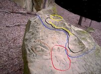
Here's a picture, Dsty.

700 map.jpg

It's egg shaped but I couldn't get it all in the picture. It's about 5 feet by 3 feet and knee high and slants up to a little above knee high. The top is fashioned to show the terrain in the immediate area of the bluff. The blue line is the creek, black is a trail, orange is a hill across the creek, yellow shows the parts of the bluff where most of the carvings are and red circles a carved mule head that I thought might be important to the map.
 

tinhorn

Full Member
Jul 28, 2011
220
228
first of all let me say sorry boys for being away from the computer for awhile... i'll try to do better.

Mdog,

I would start a search for the old settlement from the water source. The rivers and streams were marked very similar to trails. I would check for the anchor drill holes along the shore and/or signs visible from the water showing different direction of travel. I've seen some of these things that are only visible when water levels are low. If there was a settlement there should be some pretty obvious signs to your trained eye...not the eye of archeologist!
 

Top Member Reactions

Users who are viewing this thread

Latest Discussions

Top