Thamudic carved stones and marks !!

Rakan

Greenie
Jan 14, 2017
15
6
Primary Interest:
All Treasure Hunting
Greeting dears,,

It is my great pleasure to be a member of this great website.

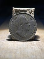
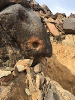
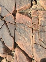
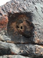
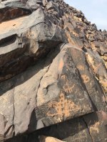
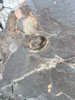
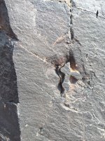
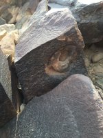
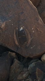
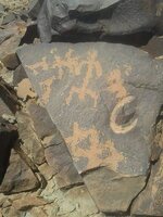
I have brought to you a group of photos that is related to an old civilization at North West of Arabian peninsula(100 km from Mada'in Saleh),it has so many carved stones and marks which indicate the important of the location , unfortunately no one was able to solve the mystery behind this marks. I will leave you with pictures and I am sure that you will help me solve it. if you need further explanation please contact me.

Thank you brothers in advance !!
 

Attachments

  • 3.jpg
    3.jpg
    268.1 KB · Views: 98
  • 5.jpg
    5.jpg
    326.3 KB · Views: 76
  • 4.jpg
    4.jpg
    307.8 KB · Views: 92
  • 9.jpg
    9.jpg
    263.3 KB · Views: 87
  • 13.jpg
    13.jpg
    315.9 KB · Views: 80
  • 11.jpg
    11.jpg
    357.9 KB · Views: 86
  • 12.jpg
    12.jpg
    250.4 KB · Views: 82
  • 14.jpg
    14.jpg
    106.1 KB · Views: 95
  • 18.jpg
    18.jpg
    72.6 KB · Views: 89
Last edited:
OP
OP
R

Rakan

Greenie
Jan 14, 2017
15
6
Primary Interest:
All Treasure Hunting
Any ideas ?even the small thought could be helpful
Thanks
 

elh

Sr. Member
Aug 10, 2015
494
590
Primary Interest:
All Treasure Hunting
Any ideas ?even the small thought could be helpful
Thanks

Third photo is shadow owl with right ear pointing the way to travel. Do not know about drill holes.
 

dsty

Bronze Member
Dec 2, 2007
1,300
736
Randal County
My experience with dots are that they will represent Trails , the other drill hole's that ( top two ) one represent distance and the cylinder one ( horzional ) possibly = a pull point direction or a religious site or both. I need the measurement's of both holes
 

OP
OP
R

Rakan

Greenie
Jan 14, 2017
15
6
Primary Interest:
All Treasure Hunting
Thank you brothers for your valuable inputs , I will get a new photos with a scale attached to each one of them, further more I will draw a site layout with arrows so it will be easy to understand.
I have a question to you brother dsty based on your rich experience ,do you think this site have something valuable? Treasure in underground room or cave, or it's a tomb maybe.
And what did you mean by "pull point"?
Also find attached photo of other location found 300 meter west of the original location, we dig around 1 meter and found this stone with this mark, the rocks is very hard and could not be moved, hope to be useful.
Thank you all again and I hope to get an answer to my questions.
Best regards,,

image.jpeg
 

Last edited:

dsty

Bronze Member
Dec 2, 2007
1,300
736
Randal County
It is my thoughts that this entire world has been surveyed everything is measured from London, ( pin point ( Big Ben ) is my thoughts ) this looks to me like the survey work was done by the English from East to West and from North to South. The lay out or the patterns was placed by the Jesuit Priest, Stone Masons got involved All of this was overseen by the King, Vikings were involved It is my guess the first landing was in the North East part of the country. The gold, treasures Jewels of all sort was loaded from the South East part of the U.S. because of the River Travel.( How many boats were turned up side down in the River's ) Looking for Vaults they were 10 leagues apart they were for storage digging tools or ground working, land clearing. They measured the Settlers lands one league square much like our sections are one mile square and they used East West North South Magnetic That's why when you find a carving and its important to identify its direction to identify it as a survey marker or a trail marker. Am I wasting my time with this stuff
 

dsty

Bronze Member
Dec 2, 2007
1,300
736
Randal County
Rakan , this is a fantastic dig here markings, Bear Head = cave 0 = gold, the nose should tell you the distance ( depth ) BUT its NOT the place to DIG it just to tell you what to look for and to keep you busy with a shovel. I need more information, its probably a corner marker, I will give you more information as to how every thing should be laid out, it will be a square with equal sides, Rectangle with two long sides and two short sides or a Triangle with one short side and two long sides. But I believe it should be the South East corner so I would measure / direction Magnetic North to another Carving or feature, I would look for something at for least 600 paces North /West /east/ south Look for another corner,
 

dsty

Bronze Member
Dec 2, 2007
1,300
736
Randal County
Pull point = place a stake in the ground on an angle, the direction that its hardest to pull out is the direction to go.
 

OP
OP
R

Rakan

Greenie
Jan 14, 2017
15
6
Primary Interest:
All Treasure Hunting
Please find below more photos with dimensions , I would appreciate every one involvement on this.
1
1338.JPG
2
1372.JPG
3
1375.JPG
4
1377.JPG
5
1384.JPG
6
1386.JPG
7
1392.JPG
8
1393.JPG
9
1403.JPG
10
1409.JPG
12
1410.JPG
13
1420.JPG
14
1369.JPG
15
1368.JPG
16
1339.JPG
17
1340.JPG
18
1350.JPG
19
1351.JPG
20
1352.JPG
21
1353.JPG
22
1355.JPG
23
1357.JPG
24
1362.JPG
25
1363.JPG
26
1366.JPG
27
1430.JPG

BR,,,
 

Last edited:
OP
OP
R

Rakan

Greenie
Jan 14, 2017
15
6
Primary Interest:
All Treasure Hunting
Please find below description of the numbered photos:

• Photos 7 and 8 : in one location ( i named it as B) around 300 meter away west of the original location ( please note it is 1 meter underground)( I named it A)
• Photo 9: in one location (B) around 300 meter away west of the original location, on surface.
• Photo 6: in the middle between the two locations (A) and (B) around 150 meter and pointing to location B, it is at top of mountain.
• Photo 10 & 12: is 50 meter south of location A.
• Photo 1: is located at location A and pointing to B, and to photo 6. (as it’s in the middle)
• Photo 23, 24 and 25: is found at location A and was hidden under big rocks.
• Photo 27: is around 350 Meter east from location A ( Note there is carving and marking but I did not take photos)
• Photo 16: the carved eye is looking to photo 18, distance between them is around 6 meter. ( location A)
• Photo 21: is around 1 meter from photo 18. (Location A)


Please note that most of the marks and carving are at location A.


Thank you brothers all in advance.

Best regards
 

Last edited:

Tnmountains

Super Moderator
Staff member
Jan 27, 2009
18,714
11,703
South East Tennessee on Ga, Ala line
🥇 Banner finds
1
Detector(s) used
Tesoro Conquistador freq shift
Fisher F75
Garrett AT-Pro
Garet carrot
Neodymium magnets
5' Probe
Primary Interest:
All Treasure Hunting
I think a lot of the pictures are natural rock concretions, petroglyphs and ancient man pecking around them. I am not sure they are pointing to a treasure but some show the presence of ancient cultures. I have read that when showing a direction in that culture they would use 3 dots to represent the constellation Orion to point a way. Loose geoligical and weathered formations often cause the brain to see what is called a pareidolia or mimetoliths. You have some nice pictures of petroglyphs though.
[h=2]Have fun![/h]
 

OP
OP
R

Rakan

Greenie
Jan 14, 2017
15
6
Primary Interest:
All Treasure Hunting
Thank you dear for your reply , however I have strong feeling that this symbols lead to something , maybe worthless stuff but at least a thing , especially if you read about thamudic civilization which lived around 5000 year BC and how the used to burry their kings and masters in under ground tombs , and how they carved the mountains to make their homes . If you see it in nature you will know that the effort and time spent to make remarkable drill hole and marks some of them are hidden under ground wasn't for nothing, most of the marks comes as 12 cm animal eye (Cat) , I don't know but let us Waite for more opinions , the only image that I suspect it is natural is photo number 13 , other I am 100 % sure it is man made.
I hope to hear more from the experts here such as Mr. Dsty , as I try to make it easy for analysis as much as I can , I know this civilization is kind of strange because of its location , as many of them still out of scientific study and analysis range .
BR,,
 

Charl

Silver Member
Jan 19, 2012
3,053
4,680
Rhode Island
Primary Interest:
Relic Hunting
I agree with Tnmountains. The petroglyphs themselves can easily be many thousands of years old. I would not presume it involves treasure.
 

Top Member Reactions

Users who are viewing this thread

Top