Help with tree symbols please, first trip to a very promising location

utah hunter

Hero Member
Jul 30, 2007
724
11
Utah county, Utah
Detector(s) used
Minelab x-terra 70, Fisher F75, eyes, brain
I went to a not so well searched location where a Spanish cache exists(unless it has been removed of course). There was a mine nearby and there is a map showing some good detail but a few of the symbols on the map seem to have been made for the map maker to understand alone. The First trip to the site yielded some interesting information to decipher.

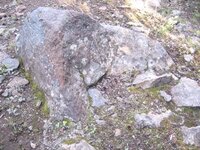
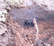
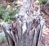
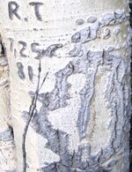
First the rock in the picture and the charcoal. Could the rock have been part of a smelter? It is not any I have seen before, but the charcoal was next to it at 6 inches, and the only reason I found the charcoal is that it set my detector off giving a penny/dime signal. With my 2 box detector I got a signal 5 feet from the rock that I didn't get from my standard coil, so it is deep. I didn't dig as it was more of an information gathering mission and the ground is very rocky and mineralized. The rock and signals are along what seems to be a trail. Within 100 feet are several hand hewn trees, I have also added a picture of one of these trees, does the age seem right(175 years)?

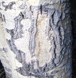
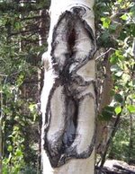
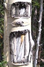
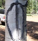
Next to these is the first tree symbol I have posted. I have no clue what it is. I have then posted several tree symbols I have found in the area. Some may be too recent, but I will leave it up to the experts here on tnet.

The area is 10,000 feet in elevation, so trees grow very slowly. Winters are long and very harsh. The map is pretty amazing in its detail for its age, and matching it up with google earth is pretty fascinating. The goal is 500 Spanish gold bars of unknown weight from a mine in the same area. Let me know what you think...Ryan
 

Attachments

  • kennedy\'s 210.jpg
    kennedy\'s 210.jpg
    72.5 KB · Views: 1,152
  • kennedy\'s 209.jpg
    kennedy\'s 209.jpg
    61.2 KB · Views: 1,190
  • kennedy\'s 205.jpg
    kennedy\'s 205.jpg
    62.7 KB · Views: 1,200
  • kennedy\'s 212.jpg
    kennedy\'s 212.jpg
    53.8 KB · Views: 1,150
  • kennedy\'s 202.jpg
    kennedy\'s 202.jpg
    52.3 KB · Views: 1,153
  • kennedy\'s 203.jpg
    kennedy\'s 203.jpg
    43.7 KB · Views: 1,144
  • kennedy\'s 201.jpg
    kennedy\'s 201.jpg
    48.6 KB · Views: 1,158

Twisted Fork

Hero Member
Sep 2, 2007
723
52
UTAH
Detector(s) used
tf900 & a good old fashioned willow forked limb
Howdy Ryan: You mentioned two hand cut trees. If the hit from your detector sounded off next to a rock, between the two trees at a point somewhat off center, chances are there is something worth looking into. Photo 210 reminds me of a map stone system. Does the stone resemble the shape of the mountain your on? Photo 212 may represent a view from the air of the site as in the tree line surrounding the location, or the shape of a meadow some distance away, with a pointer needle through it's center to show a pin point in the meadow. As a reference, some similar carvings that I have seen leading to a mine at Soapstone, held the mine at a location to the left of the aerial carving as you face the tree sign. Right Angles are the key to walking out these puzzles. I agree with you that the trees grow slower as they spend most of the year in a frozen state but it is still a good question as to who really made the carving. I saw a similar carving to photo 203 at the north end of Lightning Ridge, that was positioned about 80' above a rock capped mine. The capstone was to the right beyond the marker. Either way, I would search a 180' circle around #203. I hate giving advise like this with the cost of gas and the general frustration of being sent on a wild goose chase but it does look like the Spanish were there. Twisted
 

Twisted Fork

Hero Member
Sep 2, 2007
723
52
UTAH
Detector(s) used
tf900 & a good old fashioned willow forked limb
Something important I forgot to mention is to line up a sight line across the top of the two hand chopped trees. First look to one side or the other of the two trees and look for another old tree or large rock and tree that will represent the apex of a triangle. This tree may be blazed with a axe mark or similar sign. Of the two chopped trees below this apex, return to the one chopped, that is farthest away. This will be corner 3 of this infield triangle. Site a line across the tops of the two tree stumps and then swing out a new imaginary line, away from this corner 3 of the triangle, at a radius of say somewhere between 4 and 8 compass degrees. If there is a mine, it will probably be covered with a rock and a good 180' away or more. Good Hunting, Twisted.
 

OP
OP
utah hunter

utah hunter

Hero Member
Jul 30, 2007
724
11
Utah county, Utah
Detector(s) used
Minelab x-terra 70, Fisher F75, eyes, brain
Thanks for the ideas. The map actually gives a very good idea of the location of the mine and several other features, including the supposed location of the cache. I have my reasons for thinking the cache is not exactly where it is thought to be on the map, and I think the symbol in pic 212 could be extremely important in making a great find. Here is another pic of that symbol that helps date it. The initials from 1981 haven't changed a whole lot in 26 years, think of how long it took this symbol to age the way it has
 

Attachments

  • kennedy\'s 211.jpg
    kennedy\'s 211.jpg
    45.7 KB · Views: 1,123

Twisted Fork

Hero Member
Sep 2, 2007
723
52
UTAH
Detector(s) used
tf900 & a good old fashioned willow forked limb
I can better see the outlines in this version. That is a finger, pointing to one of the topped of trees. On paper, it is a point to cut across on the map with a penknife. At full scale face value it is a simply that reference of a large blade applied to a tree giving it a flush top. The dark square jutting in an inch to it's left is chopped corner three you are to stand at. The two fingers sticking out of the outside on the left of the circle are a side view of the two chopped trees turned at a right angle; pointing out the apex which is far enough away to not be visible from corners 2 & 3 on the ground. The white bark outline inside the left half of the circle, is as a man standing and pointing that way, winged in reference to as the crow flies. The white bark outline inside the right half of the circle may be an outline of a bare patch along an area opposite. We are working with repetitive reference where in nature is repeating it'self over and over again, in an endless sequence of graphic glyphed scales. Reading them requires standing both close and far away to pull the inside out of it. Fun Stuff. from a Bird's Eye View. Twisted
 

Twisted Fork

Hero Member
Sep 2, 2007
723
52
UTAH
Detector(s) used
tf900 & a good old fashioned willow forked limb
indexIce.jpg

Here is a sample of an effect that can be obtained with Irfan View freeware from www.download.com thru it's effects browser menu. Frankly, Ryan's photo gets across best in this case, but in many stone and tree glyphs it can be quite effective. I often use the "negative" selection under "Images" on the top bar. Enjoy
 

Twisted Fork

Hero Member
Sep 2, 2007
723
52
UTAH
Detector(s) used
tf900 & a good old fashioned willow forked limb
Ryan: Looking back at 203; This may represent a main portal and an air vent directly above it or a cave like cubby as a landmark to locate the fault line running down to the capped entry below.. I would take the double box into the section as described above, and look for signs of a vein or fault line surfacing on the slope beyond the markers. The only sign of it may be a length of raise in the forest floor, or an intermittent rocky break running through the trees. They should be on the same line, one above the other. Otherwise the upper as an air vent, may be concealed to look like an animal burrow or closed leaving what looks like an upper lip of a cave extrusion sticking up out of the ground...... Twisted
 

Twisted Fork

Hero Member
Sep 2, 2007
723
52
UTAH
Detector(s) used
tf900 & a good old fashioned willow forked limb
MasterMapInsert2.jpg

I knew I had seen these graphics before. This photo is a section of a Miera Overlay set I did years ago. Notice any similarities?
Domingez and Escalante were not here to say howdy to the natives as their fanfare trip portrays. They were really sent by their Government to take inventory on the remaining tons of bullion stashed in a mountain vault near Spanish Fork, Utah. They were truly sweating it over the westward expansion, and were here to figure out the best trail to use in order to move the bullion out of the region. The newly discovered gold mines west of modern day Grantsville, Utah, also explains why Miera's quads define the northern perimeter of their travel that historians still figure as being off to this day. The complete map translation can be viewed at "The Treasures of Utah" message EZ board under "Clues" - 1856 Pine Mine Map. (find it through www.dogpile.com) It is Miera's master cartoon satire, laughing at the French as they (the Spanish) have hid all of that stinky cheese (gold) right under their noses and presented them with a map that even to this day is thought to be a crud relief of nimble minded explorers. It really holds the location to all of the mines and vaults in the northern section. I call it Miera's Dogleg Map. The Spaniards seemed to think that the new French percussion dogleg pistol design was somewhat foolish compared the norm. Twisted
 

OP
OP
utah hunter

utah hunter

Hero Member
Jul 30, 2007
724
11
Utah county, Utah
Detector(s) used
Minelab x-terra 70, Fisher F75, eyes, brain
Arizona Ed said:
pictures 202 & 203 i have always read them as U S Forrest service
trail markers. I could be wrong...

Ed

Do you mean 203 and 201? You could be right on that one, as I thought they might be also. This area is close to the great western trail and those last 2 symbols are the ones I thought were probably too new to be spanish, especially 201. 202 is too old to be forest service, being at least 150 years old.

What is amazing is I barely scratched the surface in this area. I could spend a month there and only begin to uncover its secrets. It will be snowing up there by the end of the month so time is about up for this season. The elevation of the hewn trees and tat area is 10, 284 feet(google earth is amazing!) Hopefully I can get one more trip up there.
 

Arizona Ed

Greenie
Jul 31, 2006
16
0
Utah Hunter
I spent a lot of time in the hi country in colo. in the 1930&1940s.
My dad told us kids that a small and a large cut on a post or a tree
was a trail marker and they were mostley on aspen trees.....
keep looking you never know what you will find.
Ed
 

Twisted Fork

Hero Member
Sep 2, 2007
723
52
UTAH
Detector(s) used
tf900 & a good old fashioned willow forked limb
Another obvious clue to keep in mind: There was just an animal trail here at one time. Otherwise, tree position can reference burro/horse/ox cart if it is still possible to get a fell for the original trail. The older the the age of the wood cutters road you see now, compared to the marker's distance away may clue some. Many original carvings were made from off the back of a horse or designed to be scoped from that height. One might miss the next marker or land form sign, if they were standing on the ground. Good Luck Ryan. Twisted
 

Old Dog

Gold Member
May 22, 2007
5,860
397
Western Colorado
Nice catch twist,

Many of the signs and symbols I have found were carved into an existing surface from a much taller vantage point than when standing on the ground.

Often a beginner will miss some important things, simply because he fails to look up a little farther.

Thom
OD
 

Twisted Fork

Hero Member
Sep 2, 2007
723
52
UTAH
Detector(s) used
tf900 & a good old fashioned willow forked limb
Ya Buddy; How many times have I driven all of the way home, before that lingering whim hit me up the side of the head? Twisted
 

OP
OP
utah hunter

utah hunter

Hero Member
Jul 30, 2007
724
11
Utah county, Utah
Detector(s) used
Minelab x-terra 70, Fisher F75, eyes, brain
Springfield said:
Have you guys used an increment borer to determine the ages of these carved trees?

I haven't, but thanks to people carving their initials in them with dates going back 50 years it gives a perfect timeline of how old the trees are by how the markings deepen over time. With the elevation being over 10,000 feet the trees grow slower than they would at a lower elevation. I have learned that the circles with a line in the middle were used by the spanish, and the forest service copied their use directly from the spanish to mark their trails. That explains why there were some newer and some older
 

Old Dog

Gold Member
May 22, 2007
5,860
397
Western Colorado
Ryan,

What kind of a tree is that with the circle marker?
I suspect in this part of the country it is a Quakie,
Something else to think about.
An average Quakie only lives 40 to 80 years.

Springfield has a very good point,
My Dad and Grandfather were both Forest Service,
Yes they did copy the Spanish marks when blazing a trail, or marking timber.

OD
 

OP
OP
utah hunter

utah hunter

Hero Member
Jul 30, 2007
724
11
Utah county, Utah
Detector(s) used
Minelab x-terra 70, Fisher F75, eyes, brain
Old Dog said:
Ryan,

What kind of a tree is that with the circle marker?
I suspect in this part of the country it is a Quakie,
Something else to think about.
An average Quakie only lives 40 to 80 years.

Springfield has a very good point,
My Dad and Grandfather were both Forest Service,
Yes they did copy the Spanish marks when blazing a trail, or marking timber.

OD

Quakies do have shorter life span at lower elevation, which to me means 4,500 to 5,000 feet. Above 8,000 feet the lifespan increases dramatically for quakies. Many documented spanish symbols in the uinta mountains in Utah(documented because they led to mines) are in quakies. If you are not checking quakies in higher elevations for markings you could miss some extremely important clues in your search. Here is a link to some examples of symbols in quakies. I have several of this mans books and he has spent more time following spanish trails and symbols than most of us could ever dream of. http://ancienttreasurehunter.com/acontent/spanishsymbols.htm
 

Old Dog

Gold Member
May 22, 2007
5,860
397
Western Colorado
Ryan,

Where I am there isn't too much chance of getting that high.
We find cottonwoods with Spanish marks, some old firs and spruce But mostly monuments and chiseled marks. All rarely below shoulder height.

Thom
 

Top Member Reactions

Users who are viewing this thread

Top