Trail Signs and Monuments-Spanish or Somebody Else

OP
OP
M

mdog

Bronze Member
Mar 22, 2011
2,320
4,376
OP
OP
M

mdog

Bronze Member
Mar 22, 2011
2,320
4,376
Well, if you want to find a Spanish heart, you have to find the trails that were used by the Spanish. Here is a link that shows the trail going north from Mexico City to Santa Fe.

The Trail | CARTA

Here is the definition of a paraje.

Paraje, a Spanish term in use among English speakers in the southwestern United States, refers to a camping place along a long distance trail where travelers customarily stopped for the night. A paraje can be a town, a village or pueblo, a caravanserai, or simply a good location for stopping. Parajes typically are spaced 10 to 15 miles apart and feature abundant water and fodder for the travelers' animals (cattle, sheep, and horses).
A route between two parajes, that is difficult but must be traversed in one day because there is no water along the way, is known as a jornada.[SUP][[/SUP]
 

L.C. BAKER

Silver Member
Sep 9, 2012
3,805
4,643
Nebraska City, Nebraska
Primary Interest:
Other
L.C. I'd like to hear a little about the copper expedition if you don't mind.

In 1820, Cass led an expedition to the northwestern part of the Michigan Territory, There was an early interest in Copper by a group of investors I researched and ran across the info... There was a very large boulder made of copper recovered from the region known as the Ontonagon Boulder. The Indians were still fighting for it to be returned to them in 1991!

https://en.wikipedia.org/wiki/Ontonagon_Boulder


https://en.wikipedia.org/wiki/Lewis_Cass_expedition


https://www.loc.gov/item/rc01001453/
 

Last edited:

sdcfia

Silver Member
Sep 28, 2014
3,649
8,864
Primary Interest:
Other
Well, if you want to find a Spanish heart, you have to find the trails that were used by the Spanish. Here is a link that shows the trail going north from Mexico City to Santa Fe.

The Trail | CARTA

Here is the definition of a paraje.

Paraje, a Spanish term in use among English speakers in the southwestern United States, refers to a camping place along a long distance trail where travelers customarily stopped for the night. A paraje can be a town, a village or pueblo, a caravanserai, or simply a good location for stopping. Parajes typically are spaced 10 to 15 miles apart and feature abundant water and fodder for the travelers' animals (cattle, sheep, and horses).
A route between two parajes, that is difficult but must be traversed in one day because there is no water along the way, is known as a jornada.[SUP][[/SUP]

This trail was brutal for users, especially between El Paso and Santa Fe, where for centuries there was no security for them. Not only was travel itself arduous and dangerous following the Rio Grande, but the Natives were always looking to murder travelers, first the Spanish and later the Americans. No guaranteed easy passage until they built I-25. OK, a bit of exaggeration, haha. These two books describe life on the trail in the early Anglo days, ca 1840s.

https://www.amazon.com/Down-Santa-Trail-into-Mexico/dp/0803281161

https://www.amazon.com/Commerce-Pra...1946&sr=1-1&keywords=commerce+of+the+prairies
 

OP
OP
M

mdog

Bronze Member
Mar 22, 2011
2,320
4,376
This trail was brutal for users, especially between El Paso and Santa Fe, where for centuries there was no security for them. Not only was travel itself arduous and dangerous following the Rio Grande, but the Natives were always looking to murder travelers, first the Spanish and later the Americans. No guaranteed easy passage until they built I-25. OK, a bit of exaggeration, haha. These two books describe life on the trail in the early Anglo days, ca 1840s.

https://www.amazon.com/Down-Santa-Trail-into-Mexico/dp/0803281161

https://www.amazon.com/Commerce-Pra...1946&sr=1-1&keywords=commerce+of+the+prairies

Thanks Sdc. You might be able to read Commerce of the Prairie online.

Another event, that made life hard for the early settlers, was the weather patterns, at the time. The Little Ice Age was still going on so the winters were a lot harsher and the droughts were more brutal.

https://www.desertusa.com/desert-activity/little-ice-age.html
 

Last edited:
OP
OP
M

mdog

Bronze Member
Mar 22, 2011
2,320
4,376

Sdc, something you've mentioned in the past,was the lack of silver and gold found in New Mexico, during the early settlement. Santa Fe was a poor settlement and lacking in everything, so why did the Crown continue to support it? The link above explains why. The King wanted to use Santa Fe as a headquarters to supply the northern search for the Northwest Passage. This makes sense, as the French were doing the same thing in the Upper Mississippi Valley. Marquette and Joliet explored the Mississippi River between the Wisconsin River and the Arkansas River during the late 16oos, but they were treasure hunters. They were looking for two cities of gold and they were looking for the Northwest Passage.
 

cyzak

Bronze Member
Jul 14, 2018
2,340
3,802
Mountains of Western Colorado
Detector(s) used
Garrett, General Mathematics, Geometry,Pentax,,Do the math it's there.
Primary Interest:
All Treasure Hunting
There was a big native Indian village located were Santa Fe was I can not remember what they called it but the Spanish found it in there explorations so that is the main reason they moved there everything was already in place they just had to take it over.You have to think about it they had and established food and water source there and that was a big deal back then plus the labors to take care of them.
 

OP
OP
M

mdog

Bronze Member
Mar 22, 2011
2,320
4,376
There was a big native Indian village located were Santa Fe was I can not remember what they called it but the Spanish found it in there explorations so that is the main reason they moved there everything was already in place they just had to take it over.You have to think about it they had and established food and water source there and that was a big deal back then plus the labors to take care of them.

From the link, it seems like the officials in Mexico were getting a lot of intellegence from Spanish slavers. The slavers probably would have known about the village you mention, maybe even on friendly terms.
 

sdcfia

Silver Member
Sep 28, 2014
3,649
8,864
Primary Interest:
Other
Sdc, something you've mentioned in the past,was the lack of silver and gold found in New Mexico, during the early settlement. Santa Fe was a poor settlement and lacking in everything, so why did the Crown continue to support it? The link above explains why. The King wanted to use Santa Fe as a headquarters to supply the northern search for the Northwest Passage. This makes sense, as the French were doing the same thing in the Upper Mississippi Valley. Marquette and Joliet explored the Mississippi River between the Wisconsin River and the Arkansas River during the late 16oos, but they were treasure hunters. They were looking for two cities of gold and they were looking for the Northwest Passage.

Spain was familiar with a fair part of NM after Coronado and they were wont on expanding their holdings. Santa Fe was not much, but it was a permanent outpost from which to explore for metals and other resources. They took what they needed from the Natives but they didn't have a lot of success and things went pretty slow. Of course, their treatment of the Natives came back to haunt them in 1680 when the tribes rebelled and ran them out all the way back to El Paso. They came back thirty years later and it took another hundred years before they established much of a trade network. By then the French were nearby and the Americans too. When you note that Spain lost NM in 1848, you realize that in 250 years, they didn't accomplish a lot.
 

sdcfia

Silver Member
Sep 28, 2014
3,649
8,864
Primary Interest:
Other
There was a big native Indian village located were Santa Fe was I can not remember what they called it but the Spanish found it in there explorations so that is the main reason they moved there everything was already in place they just had to take it over.You have to think about it they had and established food and water source there and that was a big deal back then plus the labors to take care of them.

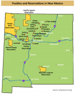
There were dozens of Native settlements in northern NM, but many have disappeared since the Spanish came in. The map below shows the ones that still exist. The first NM capital was at the San Juan Pueblo (may have been Santa Clara, I forget), then they moved it to Santa Fe in 1608. Many of the pueblos accepted Spanish rule without much resistance, but some of them, like Taos, Zuni and others, fought them hard and especially hated the church. That's still the case today.
pueblos.png
 

White Heart

Full Member
Sep 5, 2017
176
534
Primary Interest:
All Treasure Hunting
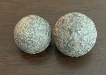
After Coronado wintered in northern New Mexico in 1541-2 his army traveled NE on what Pedro de Castenada described as a "direct road". Along this road they passed 3 pueblos, two totally destroyed and one half destroyed but still occupied. The remarkable thing to Castenada was that all three pueblos appeared to have been pummeled with a barrage of "12 liter stones".
The inhabitants told of men who had come from the north 16 years before, destroying the three pueblos and laying siege to, but unable to overcome a forth. The invaders stayed around for a while, made friends with everyone and then left.
Sounds like men with trebuches or catapults to me.
WH

Journal of Pedro de Castenada, translated by Winship in the 1920's
 

OP
OP
M

mdog

Bronze Member
Mar 22, 2011
2,320
4,376
After Coronado wintered in northern New Mexico in 1541-2 his army traveled NE on what Pedro de Castenada described as a "direct road". Along this road they passed 3 pueblos, two totally destroyed and one half destroyed but still occupied. The remarkable thing to Castenada was that all three pueblos appeared to have been pummeled with a barrage of "12 liter stones".
The inhabitants told of men who had come from the north 16 years before, destroying the three pueblos and laying siege to, but unable to overcome a forth. The invaders stayed around for a while, made friends with everyone and then left.
Sounds like men with trebuches or catapults to me.
WH

Journal of Pedro de Castenada, translated by Winship in the 1920's

I remember reading about the large rocks. Castenada didn't give much information. He suggested a catapult but I couldn't tell if it was a theory of his or something the Indians told him. If the rocks were used to destroy the village, they must have been delivered by some type of catapult. He didn't really go into detail about the people who came from the north. Were they bearded white men or another Indian tribe. I've never heard of Indians using siege machines.
 

OP
OP
M

mdog

Bronze Member
Mar 22, 2011
2,320
4,376
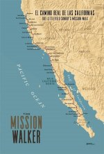
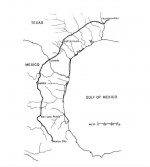
Here's the Spanish El Camino Real in California. This trail was marked by the priests.

" Tradition has it that the padres sprinkled mustard seeds along the trail to mark the windings of the trail's northward progress with bright yellow flowers, creating a golden trail stretching from San Diego to Sonoma."

https://en.wikipedia.org/wiki/El_Camino_Real_(California)

camino real cal and baj 700.jpg
 

OP
OP
M

mdog

Bronze Member
Mar 22, 2011
2,320
4,376
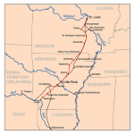
And again, here is the Camino Real from Mexico City to St. Louis. This trail goes through a huge silver producing area at San Luis Potosi.

ElCaminoReal1700s.jpg.w560h622.jpg

natchitoches to st louis 600.png
 

OP
OP
M

mdog

Bronze Member
Mar 22, 2011
2,320
4,376
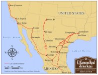
Here are all the El Camino Reals, except for the Florida trail.

Los_Caminos_Reales_DQ.jpg
 

sdcfia

Silver Member
Sep 28, 2014
3,649
8,864
Primary Interest:
Other
View attachment 1674535

View attachment 1674536
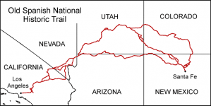
If you are looking for heart, owl triangle sites, this trail might be your best bet.

There's no doubt those routes in the top map were explored by Spanish prospectors operating out of Santa Fe sporadically in the 1700s mostly. A handful of sites seem to support this. There are plenty of other legends and allegations about mondo rich mines in southern CO and UT that were hidden, but not much red meat to support those.

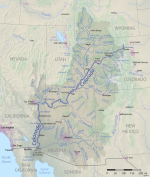
The bottom map shows the Colorado River drainage basin. This entire area was methodically explored - every single river and flowing creek - by trappers ca 1820 to about 1850 more or less. These were French, Spanish and Americans. There are lots of their journals and testimonies available about their activities, things they found and the general politics of the times. They were always on the lookout for gold, mainly placer of course. The lost Pegleg Smith Mine in CA is one of those. Interestingly, these guys made many caches - hundreds? - of equipment and beaver pelts over the years. They marked the stashes with tree blazes, rock carvings, cairns, etc and undoubtedly left other evidence behind at their many campsites in the region. I suspect that perhaps a substantial number of "Spanish treasure signs" may, in fact, have been created by the trappers.

After 1850, American prospectors began drifting into the region. They too left markers in their explorations. Some likely led to mineral discoveries, some likely led nowhere.
 

sdcfia

Silver Member
Sep 28, 2014
3,649
8,864
Primary Interest:
Other
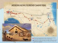
Here is the Spanish El Camino Real in Florida. There is a mention, in this article, about a suggestion to transport silver coins overland from Vera Cruz, Mexico to St. Augustine, Florida.

https://en.wikipedia.org/wiki/El_Camino_Real_(Florida)

View attachment 1674538

Florida is where Cabezo de Vaca, Estevanico and the rest of that party was shipwrecked back in the 1530s. Of course, they finally wandered all the way to southern NM and helped spark interest in the 7 Cities legends.
 

Top Member Reactions

Users who are viewing this thread

Top