allenroyboy
Jr. Member
I found this on-line. The illustrations are at the end of the article. Especially read the "historical synopsis" and "Recent excavations" at the end.
THE LEADING EDGE JULY 1998 p. 927-934 pub by the Society of Exploration Geophysicists
Treasure hunting with direct-arrival transmission imaging
JOHN WASHBOURNE, TomoSeis, Houston, Texas
JAMES RECTOR, University of California, Berkeley, California
ALEX ALONSO, Ova Noss Family Partnership, Las Cruces, New Mexico
During the past five years, the Engineering Geoscience group at the University of California, Berkeley has been applying seismic technology in the search for two hoards of buried treasure Ñ in the challenging desert terrain of southeast New Mexico where we searched for the Victorio Peak Treasure, and in the jungles of the Philippines looking for Yamashita”s Treasure (gold and jewels supposedly hidden by the Japanese military in underground tunnels during World War II).
Our goal in both projects was to seismically detect and delineate underground voids that could possibly house buried treasure. Although neither expedition has resulted in a discovery, we have unequivocally demonstrated the ability of seismic technology to detect buried tunnels and voids at these sites.
To detect underground voids we used amplitude changes in direct arrivals traveling around these features. The use of transmitted arrivals rather than reflected arrivals dictated an acquisition geometry employing subsurface hydrophones and geophones in conjunction with impact sources (hammer blows and dynamite) both on the surface and underground. Although the subsurface geology of the sites is completely different, we have been able to employ similar techniques for both projects. We have found that transmission imaging can be used in environments where the assumptions of reflection or diffraction imaging are not met, in particular where the recorded wavefield is heavily contaminated with many different modes of scattered and converted energy.
This article concerns our first expedition, the Victorio Peak Project.
Historical synopsis.
Victorio Peak, approximately 80 miles northeast of Las Cruces (see cover photo), has long been reputed to be the site of treasure consisting of crudely refined gold bars, Spanish armor and weapons, coins, and other artifacts which have an estimated value of several billion dollars.
The Victorio Peak Treasure has been the subject of Indian lore, books, articles, government documents, and television documentaries. It has captured the attention of politicians, government officials, the military, and residents of the area. Victorio Peak is located along an ancient trading trail between Santa Fe and Chihuahua, Mexico, that the Spanish named Jornada del Muerto (the Journey of Death) due to the hostility of the desert terrain. The Apaches inhabited the valley around Victorio Peak for centuries because the only fresh water within a 40-mile radius was a spring at the base of the peak. One possible explanation for the existence of the treasure is that it was taken by the Apaches from traders passing through the region and hidden inside the mountain.
In 1937 Milton “Doc” Noss, a foot doctor from Hatch, New Mexico, discovered the treasure while on a hunting trip. Doc and several helpers removed approximately 200 gold bars from the peak. In recent interviews, the surviving assistants to Doc Noss all claimed that the treasure consisted of coins, jewels, and other artifacts. They described more than 16 000 bars of gold stacked “like cordwood” in caverns deep within Victorio Peak, guarded by two-dozen skeletons lashed to wooden posts. In 1938, Noss filed a mining claim with the New Mexico state government and photographed his discovery. He described an arduous journey of several hundred feet between the entrance at the top of the peak down to where the treasure was stored.
Circumstantial evidence points to the Apaches as the “keepers” of the Victorio Peak Treasure. The artifacts recovered by Doc Noss included Spanish conquistador armor from the 15th and 16th centuries. Noss gave Benny Samaniego, one of his helpers, a complete set of armor as partial payment (a famous photograph shows Samaniego in full regalia), and the Noss family still possesses several stirrups. The artifacts also included swords from the color guard of Emperor Maximilian. The gold bars were highly variable in their construction, possibly representing the changes in smelting processes over time. The wide range of artifacts suggests the treasure was obtained and stored over a long period. In addition, Victorio Peak was staunchly protected by Apache warriors against the United States cavalry. Chief Victorio, for whom the peak was named, defended it in several notable battles.
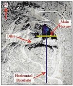
Figure 1. Aerial view of Victorio Peak which shows dike intrusion, fracturing, and slumping.
In 1939 Noss attempted to widen access to the caverns. However, an excessive charge of dynamite caused a massive collapse of the passageways. All evidence indicates that the original route Noss used was completely blocked. Over the next 10 years, Noss and his wife Ova attempted to clear the debris but were hampered by the remoteness and hostility of the terrain and by limited funds. In 1949, Doc was murdered while attempting to raise money through the illegal sale of gold bars.
Ova Noss continued her efforts to reopen access to the treasure until 1955, when the peak became part of the White Sands Missile Range (WSMR), and ownership was assumed by the U.S. Army. Although Doc and Ova had filed mining and treasure trove claims for Victorio Peak, the family was evicted from the site. In 1958, two airmen from nearby Holloman Air Force Base claimed to have discovered a cave full of gold at the peak. The army began covertly digging at the peak in 1961. Ova Noss discovered the ‘dig’ and had it halted by state officials. However, over the past 37 years, there have been numerous stories about private citizens, army personnel, and even high-ranking government officials excavating/exploring in the area.
In 1992, descendants of the Noss family regained access to the peak after a long struggle that culminated in an Act of Congress (in 1989) and the formation of the Victorio Peak Project under the Ova Noss Family Partnership (ONFP).
Geology. Victorio Peak is a bioherm reef complex located in the Hembrillo Basin, a broad topographic depression eroded into the San Andres mountain range. Fluctuating sea levels deposited Pennsylvanian-age reefs as well as shale and sandstone units in the basin. Victorio Peak might have remained as unknown as the hundreds of other reefs dotting the peaks of the San Andres mountain range if not for the intrusion of a grano-dioritic dike during Rio Grande uplifting in the Cenozoic (Figure 1). The dike, oriented east-to-west, can be traced for miles in either direction. Massive fracturing and slumping of the reef occurs north of the dike. The many fractures caused by the dike intrusion and uplifting of the reef created flow paths for water and solution cavities (caverns) under the peak. The water that formed these solution cavities has long since disappeared, and the water table is now located well below the base of the reef.
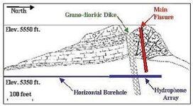
Figure 2, a north-south crosssection through the peak, illustrates the extensive fracturing in the northern portion of the reef. This is a dated cross-section; we have since discovered that the fracturing is nearly as extensive south of the dike. The main fissure on the cross-section extends 185 ft from the top of the peak to the base of the reef, and varies in width from a few inches at the top to 5-10 ft wide at the bottom.
ONFP’s initial efforts involved clearing several hundred tons of debris from the fissure in an attempt to uncover traces of Noss’ original route. Markings on the fissure walls and various excavation tools were evidence of Doc’s presence, but access to deeper passageways was not achieved. This failure prompted ONFP to try geo physical techniques. However, ground-penetrating radar and resistivity surveys were inconclusive. Consequently, in 1992, the Victorio Peak Project decided to try seismic technology.
Figure 2. Cross-section through Victorio Peak.
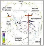
Figure 3. Survey geometry at Victorio Peak (color elevation scale).
Given the highly heterogeneous nature of the subsurface geology, we were not confident that conventional 3-D seismic would be effective. The near-vertical fissures along with the extremely large impedance contrast between the airfilled caves and the surrounding medium meant that many assumptions used in 3-D seismic were invalid. We believed that the only arrivals that could be reasonably interpreted would be the first-arriving direct transmitted energy. Secondary arrivals created by elastic-wave scattering off the air-filled fissures and voids would be too complex to utilize. Indeed, we felt that the subsurface geology would generate so much scattering that it would be extremely difficult to isolate with accuracy any component of the wavefield other than the direct arrival. The 3-D propagation of elastic waves through and around the multiple strong scatterers expected at Victorio is an extremely complex problem that was beyond the scope of our effort.
Two well-known effects on the character of direct arrivals transmitted through or around subsurface voids are (1) an increase in the travel-time and (2) a decrease in amplitude. Published scale modeling and numerical modeling confirm that most (more than 90%) of the energy propagating across strong scatterers actually finds a path around the scatterer rather than through the scatterer. The amplitude of the ‘direct’ wave traveling around strong scatterers depends on a number of factors. It is principally affected by the cross-sectional area of the scatterer along the wave path and is relative to the size of the Fresnel zone. The travel-time of the direct wave is less influenced by the scatterer, unless scattering is weak and waves are allowed to propagate through the scatterer. Consequently, we used direct-arrival amplitude anomalies as an indicator of strong scattering due to fissures and voids, and travel-time anomalies as an indicator of weaker scattering due to transmission through shale units, densely fractured dike material, and detrital sediments.
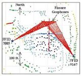
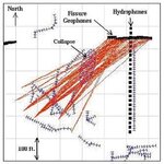
Acquisition geometry. To detect scatterers near the base of the reef (where Doc’s passageway was thought to exist) with transmitted energy required either sources or receivers located deep in the mountain. Fortunately, the debris from the main fissure had just been cleared, and we were able to instrument the walls of this fissure with geophones. In addition, we had a horizontal borehole drilled by Charrington Corporation at the base of the reef. This borehole was instrumented with hydrophones specifically for the transmission imaging. We deployed geophones and hydrophones in four different locations deep beneath the surface of the mountain. Each required considerable time and ingenuity. Troubleshooting the sensor deployment took two full weeks in the field. Figure 3 is a map view of the diverse locations of the sources and receivers. 1100 surface source positions are shown as colored squares; darker colors (green, blue, and purple) indicate source elevation. The 120-channel receiver deployment (red squares) consisted of:
• an array of 24 hydrophones (spaced 10 ft apart) deployed in a horizontal borehole at an elevation of 5350 ft
• 66 geophone positions cemented along the walls of the main fissure
• 24 geophones cemented along the walls of a secondary fissure (‘Dome Room’) 200 ft west of the main fissure
• 6 geophones cemented at the base of the ‘Dike Shaft’ a 50-ft shaft sunk by Noss through weathered dike material and into the top of the reef. Noss sunk this shaft in an attempt to intersect his original route at some distance from the debris of the dynamite blast.
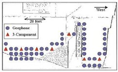
Figure 4. Geophone deployment on the south wall of the main fissure (looking south).
Figure 4 shows the locations of geophones on the south wall of the main fissure. The entrance to the main fissure (at the west end, the right side of Figure 4) consists of ladders extending 185 ft from the surface. One of Doc Noss’ excavation attempts, the Ova Noss Shaft, complicated geophone deployment. We were forced to install geophones along a course that followed up and over the shaft, rather than in horizontal lines.
The fissure geophones were cemented in holes drilled into the very competent reef limestone, on roughly 5-ft centers. Most geophones were single-component 40-Hz phones oriented perpendicular to the wall of the near-vertical fissure. In addition to the single-component stations, we had a few three-component geophone groups (red triangles in Figure 4).
For source locations south of the main fissure, we used geophones cemented to the south wall. All geophones were moved to the north wall for source locations north of the main fissure.
We used a 10-lb sledgehammer impacting an aluminum plate for the surface source. We experimented with small dynamite charges, but the hammer-on-plate source was much faster. To improve coupling and save time, most source positions were on the roads that circle the peak. We also used hammer blows on the competent limestone along the top of the reef. Acquisition of the surface seismic data required 40 days in the field. Following the data acquisition, coordinates of the geophones and more than 1100 surface sources were surveyed.
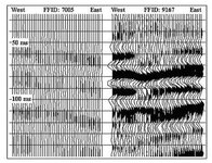
Representative data. Figure 5 shows data received by the fissure geophones for two common source gathers. As shown in Figure 6, each source was located roughly 300 ft from the center of the fissure geophone array and at an elevation of about 5400 ft. The data in Figure 5 have been band-passed from 20 to 250 Hz and have had surface-consistent amplitude corrections applied to compensate for the variable surface coupling and the variable impact power of the sledgehammer. (We found that sledgehammer blows directly on the reef limestone produced much weaker amplitudes than sledgehammer blows on the dirt road and that younger people with more body mass tended to create larger impacts than the weak and infirm.) Consequently, one of the critical components of the data processing was the application of surface-consistent amplitude corrections. These corrections were computed as scalars separately for the geophone and hydrophone data and were implemented just like conventional surface-consistent statics corrections in land-seismic data processing. We estimated the direct-arrival amplitude using a large (30 ms) time window around the reduced direct arrival time (straight raypath assumed with reduction velocity of 8000 ft/s). With more than 1100 source positions and more than 150 geophone positions, we had sufficient statistics to decompose the measured direct-arrival amplitude into source, receiver, and propagation terms.
Figure 5. Common source gathers for main fissure geophones (true amplitudes).
The dramatic amplitude and frequency- content decrease for the western source position (FFID 7005) is interpreted to be due to large scattering attenuation for the western source raypaths. The direct-arrival times for the western and eastern sources are nearly identical, supporting the hypothesis that amplitude is a better indicator of scattering than travel-time. Another interesting feature in Figure 5 is the dramatic drop in amplitude, and travel-time delay near the middle of the geophone array for the eastern source position. The middle of the geophone array (see Figure 4) corresponds to locations near the Ova Noss entrance shaft. It was found in later excavations that the anomaly here was due to a small void near ‘Big Rock’ at the top of the Ova Noss shaft (see Figure 4).
Visualization of amplitude anomalies. After the amplitude corrections for source and receiver coupling, we selected the most anomalous (lowest amplitude) data and volumetrically projected the associated straight-ray travel paths into 3-D. We noticed two surprising things. Since we had not performed a geometric spreading correction, we expected that the lowest amplitudes would correspond with the longest travel paths, from the sources along the roads below the base of the reef. Instead, we found that the lowest amplitudes corresponded with some of the shortest travel paths. Second, we noticed several very significant and coherent spatial groupings of anomalous raypaths.
Figure 6. Source locations and raypaths for data in Figure 5.
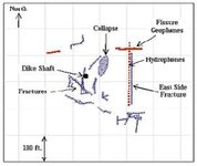
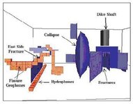
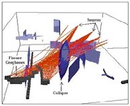
The straight-ray assumption turned out to be surprisingly effective and accurate at Victorio Peak. There is a high degree of correlation between volumetrically projected, low-amplitude anomalies and the locations of subsurface voids determined from recent excavations. Figure 7 and Figure 8 show map and 3-D perspective views of the fractures and voids that have been mapped by recent excavation at Victorio Peak. Note in particular the fracture just east of the hydrophone array, and the area labeled “collapse” northeast of the dike shaft. These features created major anomalies in the seismic data.
Figure 7. Subsurface voids at Victorio Peak.
Figure 8. 3-D view (looking south) of subsurface voids.
The most obvious seismic amplitude anomalies (such as FFID 7005) corresponded to waves affected by the zone labeled “collapse.” Some arrivals traveling near the collapse zone exhibited more than 40 dB of amplitude attenuation. Figure 9 and Figure 10 show map and 3-D perspective views of the raypaths associated with the lowest 5% of the direct arrivals recorded by the fissure geophones. Based on the seismic data, the zone was interpreted to be a major void/fissure with a vertical extent of nearly 60 ft. (The zone is labeled “collapse” because, when miners intersected this region, there was a major collapse and the ground surface above this zone dropped nearly 15 ft.) This region is thought to be one of the main treasure chambers discovered by Doc Noss.
Figure 9. Raypaths for 5% lowest-amplitude data recorded by the main fissure geophones. Anomaly is associated with the collapsed zone.
Figure 10. 3-D perspective of raypaths in Figure 9.
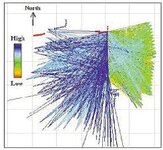
Another amplitude anomaly is evident in the surface data recorded by the hydrophones. Recent excavations allowed us to map a near-vertical fracture several inches wide just a few feet east of the hydrophone array (“East Side Fracture” on Figure 7 and Figure 8). When the hydrophone data are sorted based on amplitude, all of the low amplitudes are from source locations east of the hydrophones. Figure 11 shows the straight raypaths associated with these data. The amplitude of the rays is shown by color (reds = lowest amplitudes and blues = highest). What is especially significant about this anomaly is that the travel paths from the east are much shorter than travel paths from most other sources.
Figure 11. Volumetrically projected direct-arrival amplitudes. Raypaths are colored based on amplitude.
Recent excavations. The seismic anomalies were categorized based on their correspondence with the accounts of Doc Noss and his travels underneath the mountain. The largest seismic anomaly was centered near the dike shaft. Recall that this was dug by Doc Noss to intersect the passageway after unsuccessful attempts to clear out the debris from the original entrance. Our analysis concluded that Doc had positioned the shaft slightly southwest of a large void extending vertically for nearly 60 ft. Lesser anomalies with little historical consistency were found on the east side of the mountain and to the south of the main anomaly.
In May 1995, a mining drift was started on the west side of the mountain with the goal of intersecting the main anomaly. Within 50 ft, the drift encountered very unstable rock and required substantial shoring. Rather than continuing toward the main anomaly, it was decided to deviate the drift into more competent rock where quicker headway could be made. As shown in Figure 12 the drift snaked its way through a large portion of the region to the south of the dike, and a number of vertical fissures with widths varying from less than an inch to several feet were discovered. The major fissures correlate extremely well with seismic anomalies. Finally, in late 1996, after exploring most of the southern part of the mountain, the mining crew returned to the difficult task of extending a drift into the area near the dike shaft to investigate the main seismic anomaly. After months of laborious effort, in February 1997, the crew broke into a room nearly 60-ft high and more than 6-ft wide very near the center of the main seismic anomaly. The cavern was very unstable, and shortly thereafter the ceiling collapsed, showering several miners with bones. Clearly this cavern is one of the major treasure rooms discovered by Doc Noss.
Figure 12. Drift excavation at Victorio Peak.
Unfortunately, before detailed exploration of the cavern could proceed, the project was shut down by the U.S. Army. The reasons cited were failure to pay access fees (the Army charged the Victorio Peak Project several thousand dollars per day for access to the peak). No further work has been done at the peak by the Victorio Peak Project. Recently a lawsuit was filed on behalf of the Noss family against the U.S. Army to regain access to the peak under less financially restrictive conditions.
Suggestions for further reading. The official Victorio Peak Project Web site is http://www.victoriopeak.com. The UC Berkeley Engineering Geoscience Web site hosts a JAVA applet that provides an interactive interface to the Victorio Peak 3-D computer model. Its location is http://bozo-1.lbl.gov/users/wash/Victorio Peak. “Seismic scattering from inclusions” by Q. Dong and J. Rector (SEG 1994 Expanded Abstracts). “Fracture detection using crosswell and single well surveys” by E.W. Majer et al. (accepted for publication in GEOPHYSICS). ‘3-D seismic exploration for the Victorio Peak treasure’ by J. Washbourne et al. (SEG 1994 Expanded Abstracts). “Nearsurfaces exploration for treasure-filled tunnels in granodiorite” by Washbourne et al. (SEG 1997 Expanded Abstracts). LE
Acknowledgments: The authors gratefully acknowledge the Ova Nos Family Partnership for permission to disclose data concerning the Victorio Peak Project. The authors thank Martin Charrington for initiating our involvement and for providing logistical support for the seismic experiment. The authors also thank Rob Huggins of Geometrics for acquisition expertise.
Corresponding author: John Washbourne, 1-713-461-4620
THE LEADING EDGE JULY 1998 p. 927-934 pub by the Society of Exploration Geophysicists
Treasure hunting with direct-arrival transmission imaging
JOHN WASHBOURNE, TomoSeis, Houston, Texas
JAMES RECTOR, University of California, Berkeley, California
ALEX ALONSO, Ova Noss Family Partnership, Las Cruces, New Mexico
During the past five years, the Engineering Geoscience group at the University of California, Berkeley has been applying seismic technology in the search for two hoards of buried treasure Ñ in the challenging desert terrain of southeast New Mexico where we searched for the Victorio Peak Treasure, and in the jungles of the Philippines looking for Yamashita”s Treasure (gold and jewels supposedly hidden by the Japanese military in underground tunnels during World War II).
Our goal in both projects was to seismically detect and delineate underground voids that could possibly house buried treasure. Although neither expedition has resulted in a discovery, we have unequivocally demonstrated the ability of seismic technology to detect buried tunnels and voids at these sites.
To detect underground voids we used amplitude changes in direct arrivals traveling around these features. The use of transmitted arrivals rather than reflected arrivals dictated an acquisition geometry employing subsurface hydrophones and geophones in conjunction with impact sources (hammer blows and dynamite) both on the surface and underground. Although the subsurface geology of the sites is completely different, we have been able to employ similar techniques for both projects. We have found that transmission imaging can be used in environments where the assumptions of reflection or diffraction imaging are not met, in particular where the recorded wavefield is heavily contaminated with many different modes of scattered and converted energy.
This article concerns our first expedition, the Victorio Peak Project.
Historical synopsis.
Victorio Peak, approximately 80 miles northeast of Las Cruces (see cover photo), has long been reputed to be the site of treasure consisting of crudely refined gold bars, Spanish armor and weapons, coins, and other artifacts which have an estimated value of several billion dollars.
The Victorio Peak Treasure has been the subject of Indian lore, books, articles, government documents, and television documentaries. It has captured the attention of politicians, government officials, the military, and residents of the area. Victorio Peak is located along an ancient trading trail between Santa Fe and Chihuahua, Mexico, that the Spanish named Jornada del Muerto (the Journey of Death) due to the hostility of the desert terrain. The Apaches inhabited the valley around Victorio Peak for centuries because the only fresh water within a 40-mile radius was a spring at the base of the peak. One possible explanation for the existence of the treasure is that it was taken by the Apaches from traders passing through the region and hidden inside the mountain.
In 1937 Milton “Doc” Noss, a foot doctor from Hatch, New Mexico, discovered the treasure while on a hunting trip. Doc and several helpers removed approximately 200 gold bars from the peak. In recent interviews, the surviving assistants to Doc Noss all claimed that the treasure consisted of coins, jewels, and other artifacts. They described more than 16 000 bars of gold stacked “like cordwood” in caverns deep within Victorio Peak, guarded by two-dozen skeletons lashed to wooden posts. In 1938, Noss filed a mining claim with the New Mexico state government and photographed his discovery. He described an arduous journey of several hundred feet between the entrance at the top of the peak down to where the treasure was stored.
Circumstantial evidence points to the Apaches as the “keepers” of the Victorio Peak Treasure. The artifacts recovered by Doc Noss included Spanish conquistador armor from the 15th and 16th centuries. Noss gave Benny Samaniego, one of his helpers, a complete set of armor as partial payment (a famous photograph shows Samaniego in full regalia), and the Noss family still possesses several stirrups. The artifacts also included swords from the color guard of Emperor Maximilian. The gold bars were highly variable in their construction, possibly representing the changes in smelting processes over time. The wide range of artifacts suggests the treasure was obtained and stored over a long period. In addition, Victorio Peak was staunchly protected by Apache warriors against the United States cavalry. Chief Victorio, for whom the peak was named, defended it in several notable battles.
Figure 1. Aerial view of Victorio Peak which shows dike intrusion, fracturing, and slumping.
In 1939 Noss attempted to widen access to the caverns. However, an excessive charge of dynamite caused a massive collapse of the passageways. All evidence indicates that the original route Noss used was completely blocked. Over the next 10 years, Noss and his wife Ova attempted to clear the debris but were hampered by the remoteness and hostility of the terrain and by limited funds. In 1949, Doc was murdered while attempting to raise money through the illegal sale of gold bars.
Ova Noss continued her efforts to reopen access to the treasure until 1955, when the peak became part of the White Sands Missile Range (WSMR), and ownership was assumed by the U.S. Army. Although Doc and Ova had filed mining and treasure trove claims for Victorio Peak, the family was evicted from the site. In 1958, two airmen from nearby Holloman Air Force Base claimed to have discovered a cave full of gold at the peak. The army began covertly digging at the peak in 1961. Ova Noss discovered the ‘dig’ and had it halted by state officials. However, over the past 37 years, there have been numerous stories about private citizens, army personnel, and even high-ranking government officials excavating/exploring in the area.
In 1992, descendants of the Noss family regained access to the peak after a long struggle that culminated in an Act of Congress (in 1989) and the formation of the Victorio Peak Project under the Ova Noss Family Partnership (ONFP).
Geology. Victorio Peak is a bioherm reef complex located in the Hembrillo Basin, a broad topographic depression eroded into the San Andres mountain range. Fluctuating sea levels deposited Pennsylvanian-age reefs as well as shale and sandstone units in the basin. Victorio Peak might have remained as unknown as the hundreds of other reefs dotting the peaks of the San Andres mountain range if not for the intrusion of a grano-dioritic dike during Rio Grande uplifting in the Cenozoic (Figure 1). The dike, oriented east-to-west, can be traced for miles in either direction. Massive fracturing and slumping of the reef occurs north of the dike. The many fractures caused by the dike intrusion and uplifting of the reef created flow paths for water and solution cavities (caverns) under the peak. The water that formed these solution cavities has long since disappeared, and the water table is now located well below the base of the reef.
Figure 2, a north-south crosssection through the peak, illustrates the extensive fracturing in the northern portion of the reef. This is a dated cross-section; we have since discovered that the fracturing is nearly as extensive south of the dike. The main fissure on the cross-section extends 185 ft from the top of the peak to the base of the reef, and varies in width from a few inches at the top to 5-10 ft wide at the bottom.
ONFP’s initial efforts involved clearing several hundred tons of debris from the fissure in an attempt to uncover traces of Noss’ original route. Markings on the fissure walls and various excavation tools were evidence of Doc’s presence, but access to deeper passageways was not achieved. This failure prompted ONFP to try geo physical techniques. However, ground-penetrating radar and resistivity surveys were inconclusive. Consequently, in 1992, the Victorio Peak Project decided to try seismic technology.
Figure 2. Cross-section through Victorio Peak.
Figure 3. Survey geometry at Victorio Peak (color elevation scale).
Given the highly heterogeneous nature of the subsurface geology, we were not confident that conventional 3-D seismic would be effective. The near-vertical fissures along with the extremely large impedance contrast between the airfilled caves and the surrounding medium meant that many assumptions used in 3-D seismic were invalid. We believed that the only arrivals that could be reasonably interpreted would be the first-arriving direct transmitted energy. Secondary arrivals created by elastic-wave scattering off the air-filled fissures and voids would be too complex to utilize. Indeed, we felt that the subsurface geology would generate so much scattering that it would be extremely difficult to isolate with accuracy any component of the wavefield other than the direct arrival. The 3-D propagation of elastic waves through and around the multiple strong scatterers expected at Victorio is an extremely complex problem that was beyond the scope of our effort.
Two well-known effects on the character of direct arrivals transmitted through or around subsurface voids are (1) an increase in the travel-time and (2) a decrease in amplitude. Published scale modeling and numerical modeling confirm that most (more than 90%) of the energy propagating across strong scatterers actually finds a path around the scatterer rather than through the scatterer. The amplitude of the ‘direct’ wave traveling around strong scatterers depends on a number of factors. It is principally affected by the cross-sectional area of the scatterer along the wave path and is relative to the size of the Fresnel zone. The travel-time of the direct wave is less influenced by the scatterer, unless scattering is weak and waves are allowed to propagate through the scatterer. Consequently, we used direct-arrival amplitude anomalies as an indicator of strong scattering due to fissures and voids, and travel-time anomalies as an indicator of weaker scattering due to transmission through shale units, densely fractured dike material, and detrital sediments.
Acquisition geometry. To detect scatterers near the base of the reef (where Doc’s passageway was thought to exist) with transmitted energy required either sources or receivers located deep in the mountain. Fortunately, the debris from the main fissure had just been cleared, and we were able to instrument the walls of this fissure with geophones. In addition, we had a horizontal borehole drilled by Charrington Corporation at the base of the reef. This borehole was instrumented with hydrophones specifically for the transmission imaging. We deployed geophones and hydrophones in four different locations deep beneath the surface of the mountain. Each required considerable time and ingenuity. Troubleshooting the sensor deployment took two full weeks in the field. Figure 3 is a map view of the diverse locations of the sources and receivers. 1100 surface source positions are shown as colored squares; darker colors (green, blue, and purple) indicate source elevation. The 120-channel receiver deployment (red squares) consisted of:
• an array of 24 hydrophones (spaced 10 ft apart) deployed in a horizontal borehole at an elevation of 5350 ft
• 66 geophone positions cemented along the walls of the main fissure
• 24 geophones cemented along the walls of a secondary fissure (‘Dome Room’) 200 ft west of the main fissure
• 6 geophones cemented at the base of the ‘Dike Shaft’ a 50-ft shaft sunk by Noss through weathered dike material and into the top of the reef. Noss sunk this shaft in an attempt to intersect his original route at some distance from the debris of the dynamite blast.
Figure 4. Geophone deployment on the south wall of the main fissure (looking south).
Figure 4 shows the locations of geophones on the south wall of the main fissure. The entrance to the main fissure (at the west end, the right side of Figure 4) consists of ladders extending 185 ft from the surface. One of Doc Noss’ excavation attempts, the Ova Noss Shaft, complicated geophone deployment. We were forced to install geophones along a course that followed up and over the shaft, rather than in horizontal lines.
The fissure geophones were cemented in holes drilled into the very competent reef limestone, on roughly 5-ft centers. Most geophones were single-component 40-Hz phones oriented perpendicular to the wall of the near-vertical fissure. In addition to the single-component stations, we had a few three-component geophone groups (red triangles in Figure 4).
For source locations south of the main fissure, we used geophones cemented to the south wall. All geophones were moved to the north wall for source locations north of the main fissure.
We used a 10-lb sledgehammer impacting an aluminum plate for the surface source. We experimented with small dynamite charges, but the hammer-on-plate source was much faster. To improve coupling and save time, most source positions were on the roads that circle the peak. We also used hammer blows on the competent limestone along the top of the reef. Acquisition of the surface seismic data required 40 days in the field. Following the data acquisition, coordinates of the geophones and more than 1100 surface sources were surveyed.
Representative data. Figure 5 shows data received by the fissure geophones for two common source gathers. As shown in Figure 6, each source was located roughly 300 ft from the center of the fissure geophone array and at an elevation of about 5400 ft. The data in Figure 5 have been band-passed from 20 to 250 Hz and have had surface-consistent amplitude corrections applied to compensate for the variable surface coupling and the variable impact power of the sledgehammer. (We found that sledgehammer blows directly on the reef limestone produced much weaker amplitudes than sledgehammer blows on the dirt road and that younger people with more body mass tended to create larger impacts than the weak and infirm.) Consequently, one of the critical components of the data processing was the application of surface-consistent amplitude corrections. These corrections were computed as scalars separately for the geophone and hydrophone data and were implemented just like conventional surface-consistent statics corrections in land-seismic data processing. We estimated the direct-arrival amplitude using a large (30 ms) time window around the reduced direct arrival time (straight raypath assumed with reduction velocity of 8000 ft/s). With more than 1100 source positions and more than 150 geophone positions, we had sufficient statistics to decompose the measured direct-arrival amplitude into source, receiver, and propagation terms.
Figure 5. Common source gathers for main fissure geophones (true amplitudes).
The dramatic amplitude and frequency- content decrease for the western source position (FFID 7005) is interpreted to be due to large scattering attenuation for the western source raypaths. The direct-arrival times for the western and eastern sources are nearly identical, supporting the hypothesis that amplitude is a better indicator of scattering than travel-time. Another interesting feature in Figure 5 is the dramatic drop in amplitude, and travel-time delay near the middle of the geophone array for the eastern source position. The middle of the geophone array (see Figure 4) corresponds to locations near the Ova Noss entrance shaft. It was found in later excavations that the anomaly here was due to a small void near ‘Big Rock’ at the top of the Ova Noss shaft (see Figure 4).
Visualization of amplitude anomalies. After the amplitude corrections for source and receiver coupling, we selected the most anomalous (lowest amplitude) data and volumetrically projected the associated straight-ray travel paths into 3-D. We noticed two surprising things. Since we had not performed a geometric spreading correction, we expected that the lowest amplitudes would correspond with the longest travel paths, from the sources along the roads below the base of the reef. Instead, we found that the lowest amplitudes corresponded with some of the shortest travel paths. Second, we noticed several very significant and coherent spatial groupings of anomalous raypaths.
Figure 6. Source locations and raypaths for data in Figure 5.
The straight-ray assumption turned out to be surprisingly effective and accurate at Victorio Peak. There is a high degree of correlation between volumetrically projected, low-amplitude anomalies and the locations of subsurface voids determined from recent excavations. Figure 7 and Figure 8 show map and 3-D perspective views of the fractures and voids that have been mapped by recent excavation at Victorio Peak. Note in particular the fracture just east of the hydrophone array, and the area labeled “collapse” northeast of the dike shaft. These features created major anomalies in the seismic data.
Figure 7. Subsurface voids at Victorio Peak.
Figure 8. 3-D view (looking south) of subsurface voids.
The most obvious seismic amplitude anomalies (such as FFID 7005) corresponded to waves affected by the zone labeled “collapse.” Some arrivals traveling near the collapse zone exhibited more than 40 dB of amplitude attenuation. Figure 9 and Figure 10 show map and 3-D perspective views of the raypaths associated with the lowest 5% of the direct arrivals recorded by the fissure geophones. Based on the seismic data, the zone was interpreted to be a major void/fissure with a vertical extent of nearly 60 ft. (The zone is labeled “collapse” because, when miners intersected this region, there was a major collapse and the ground surface above this zone dropped nearly 15 ft.) This region is thought to be one of the main treasure chambers discovered by Doc Noss.
Figure 9. Raypaths for 5% lowest-amplitude data recorded by the main fissure geophones. Anomaly is associated with the collapsed zone.
Figure 10. 3-D perspective of raypaths in Figure 9.
Another amplitude anomaly is evident in the surface data recorded by the hydrophones. Recent excavations allowed us to map a near-vertical fracture several inches wide just a few feet east of the hydrophone array (“East Side Fracture” on Figure 7 and Figure 8). When the hydrophone data are sorted based on amplitude, all of the low amplitudes are from source locations east of the hydrophones. Figure 11 shows the straight raypaths associated with these data. The amplitude of the rays is shown by color (reds = lowest amplitudes and blues = highest). What is especially significant about this anomaly is that the travel paths from the east are much shorter than travel paths from most other sources.
Figure 11. Volumetrically projected direct-arrival amplitudes. Raypaths are colored based on amplitude.
Recent excavations. The seismic anomalies were categorized based on their correspondence with the accounts of Doc Noss and his travels underneath the mountain. The largest seismic anomaly was centered near the dike shaft. Recall that this was dug by Doc Noss to intersect the passageway after unsuccessful attempts to clear out the debris from the original entrance. Our analysis concluded that Doc had positioned the shaft slightly southwest of a large void extending vertically for nearly 60 ft. Lesser anomalies with little historical consistency were found on the east side of the mountain and to the south of the main anomaly.
In May 1995, a mining drift was started on the west side of the mountain with the goal of intersecting the main anomaly. Within 50 ft, the drift encountered very unstable rock and required substantial shoring. Rather than continuing toward the main anomaly, it was decided to deviate the drift into more competent rock where quicker headway could be made. As shown in Figure 12 the drift snaked its way through a large portion of the region to the south of the dike, and a number of vertical fissures with widths varying from less than an inch to several feet were discovered. The major fissures correlate extremely well with seismic anomalies. Finally, in late 1996, after exploring most of the southern part of the mountain, the mining crew returned to the difficult task of extending a drift into the area near the dike shaft to investigate the main seismic anomaly. After months of laborious effort, in February 1997, the crew broke into a room nearly 60-ft high and more than 6-ft wide very near the center of the main seismic anomaly. The cavern was very unstable, and shortly thereafter the ceiling collapsed, showering several miners with bones. Clearly this cavern is one of the major treasure rooms discovered by Doc Noss.
Figure 12. Drift excavation at Victorio Peak.
Unfortunately, before detailed exploration of the cavern could proceed, the project was shut down by the U.S. Army. The reasons cited were failure to pay access fees (the Army charged the Victorio Peak Project several thousand dollars per day for access to the peak). No further work has been done at the peak by the Victorio Peak Project. Recently a lawsuit was filed on behalf of the Noss family against the U.S. Army to regain access to the peak under less financially restrictive conditions.
Suggestions for further reading. The official Victorio Peak Project Web site is http://www.victoriopeak.com. The UC Berkeley Engineering Geoscience Web site hosts a JAVA applet that provides an interactive interface to the Victorio Peak 3-D computer model. Its location is http://bozo-1.lbl.gov/users/wash/Victorio Peak. “Seismic scattering from inclusions” by Q. Dong and J. Rector (SEG 1994 Expanded Abstracts). “Fracture detection using crosswell and single well surveys” by E.W. Majer et al. (accepted for publication in GEOPHYSICS). ‘3-D seismic exploration for the Victorio Peak treasure’ by J. Washbourne et al. (SEG 1994 Expanded Abstracts). “Nearsurfaces exploration for treasure-filled tunnels in granodiorite” by Washbourne et al. (SEG 1997 Expanded Abstracts). LE
Acknowledgments: The authors gratefully acknowledge the Ova Nos Family Partnership for permission to disclose data concerning the Victorio Peak Project. The authors thank Martin Charrington for initiating our involvement and for providing logistical support for the seismic experiment. The authors also thank Rob Huggins of Geometrics for acquisition expertise.
Corresponding author: John Washbourne, 1-713-461-4620
Amazon Forum Fav 👍


Attachments
-
 f1.jpg31.3 KB · Views: 2,333
 -
 f2.jpg16 KB · Views: 2,150
 -
 f3.jpg26.6 KB · Views: 2,214
 -
 f4.jpg17.2 KB · Views: 2,086
 -
 f5.jpg47.7 KB · Views: 1,442
 -
 f6.jpg17.1 KB · Views: 2,185
 -
 f7.jpg10.7 KB · Views: 2,140
 -
 f8.jpg16.6 KB · Views: 2,257
 -
 f9.jpg26.5 KB · Views: 2,270
 -
 f10.jpg19.4 KB · Views: 2,457
 -
 f11.jpg17.7 KB · Views: 2,078
 -
 f12.jpg12.1 KB · Views: 2,187
 ?
?