DOC NOSS-Victorio Peak OR The Caballo Mountains

txtea

Full Member
Nov 16, 2009
156
332
I don't know about Shortstack, but, yeah, that idea is active in my noggin - and yours too, it seems. The Michigan copper mystery is very, very interesting, and if you consider the difficulty in logistics getting there from the Mediterranean, plus the Mexican Phoenician discoveries - and that Arizona cave anomaly too - well ... hello! Getting into the Southwest is almost a no-brainer.

The usual route conjectured into the Southwest was via the mouth of the Rio Grande. The river was navigatable in that age, and could have been followed to today's Organ and Caballo ranges (hmmm) - and to the Rio Puerco too, for that matter. The means of travel are apparent, but the big question is whether they were merely exploring or had maps to specific destinations.

I've been meaning to bring this up for awhile, but i've always wondered if they ever used the Rio Grande to transport their goodies to the Gulf of Mexico. I know mr Don Jose has mentioned that the goods were transported to a small bay just south of the Texas border for shipment, and I have read about that elsewhere. The river, like mr Springfield mentioned, was navigatable in those days. Curious what you guys and gals think about that possibility. Plenty of places to hide the stash along the way if need be.....maybe some left behind along the way?....hmmmm.
 

markmar

Silver Member
Oct 17, 2012
4,117
6,259
Primary Interest:
All Treasure Hunting
Hi NP

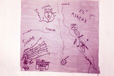
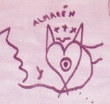
This map shows how the Tayopa's gold is/was deposited in two warehouses ( almacén ) . The first in Caballo mountains and the second in a famous heart in Arizona .
I believe how your theory about Caballo Mountains is correct .

img131.jpg
 

markmar

Silver Member
Oct 17, 2012
4,117
6,259
Primary Interest:
All Treasure Hunting
NP

Today , one bird told me where is the treasure cave in your theory . Wanna a gift ?
If you are not interested , I will think another hunter.
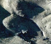
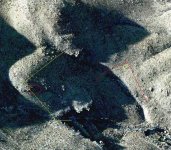
I post two aerial pictures from the spot . The first is simple and the second has drawings . Near the hill is a mark which shows the hill and where is the entrance of the cave

site map.jpg site map 2.JPG

Have a nice day
 

gollum

Gold Member
Jan 2, 2006
6,729
7,596
Arizona Vagrant
Detector(s) used
Minelab SD2200D (Modded)/ Whites GMT 24k / Fisher FX-3 / Fisher Gold Bug II / Fisher Gemini / Schiebel MIMID / Falcon MD-20
Primary Interest:
All Treasure Hunting
Bob (Kanabite),

I think you know the story I was referring to regarding the Aztec/Mayan Artifacts. (Roger Smith's Ice Cave Mummies). As I posted on Ancient Lost Treasures, there is a LOT more to that story that I am not able to share.

I am okay with Phoenicians, Chinese, Vikings, Templars, Polynesians, etc. Its just when we start talking about The Lost Continents of Mu and Atlantis that I have a problem. At least we know for 100% certain that Phoenicia and China are real places. Too many maybes and I start to lose interest. Even if I think it is possible for both Mu and Atlantis to exist, when people start making them responsible for this and that....... you know. Lets firmly establish the existence of a place before we make them responsible for something historical.

Best - Mike
 

markmar

Silver Member
Oct 17, 2012
4,117
6,259
Primary Interest:
All Treasure Hunting
Quote

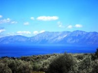
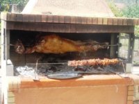
For me , all the money are , the view from my patio over the olive trees and what is roasted in my BBQ .

1.JPG 2.JPG

NP

I have not your answer .
 

markmar

Silver Member
Oct 17, 2012
4,117
6,259
Primary Interest:
All Treasure Hunting
Another quote

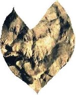
About the " fox " heart ( almacén ) in the red map , is there in Arizona , with the witch in the middle

H.jpg fox heart.jpg

Are another two stone maps which show this heart , but are smaller ( half ) and have different orientation in the " fox " heart .
Also , all show the same point , which is this

heart cave region.jpg

And now , back to Caballo Mountains .
 

OP
OP
Not Peralta

Not Peralta

Bronze Member
Mar 23, 2013
2,167
3,061
Primary Interest:
All Treasure Hunting
Markmar;
Thank-you for posting your pictures. I'm always glad to see you take an interest. Due to my health, I can't hike around like I used to. But, I'm sure someone will be glad to see your research posted here. I think you have done a wonderful job researching and studying numerous things posted on different threads. It's people like you that make a big difference in the treasure world, but receive little recognition. It's always good to have more than one person looking at clues to find the answers. The smallest clues can make the biggest difference. np:cat:
 

markmar

Silver Member
Oct 17, 2012
4,117
6,259
Primary Interest:
All Treasure Hunting
NP

I can't post my research in an open forum . This could create a great competition , with bad effects . The red map is not difficult , and if I will write only two clues about , many hunters will understand where have to research .
But , I give an opportunity to find the hill and I will write a " derrotero " to the Caballo almacén :

" The dirty and in some cases muddy 9,5 miles long road , starts from the valley east of this long and impressive mountain range . When you will be high and couldn't see the valley , you will see a small hill of debris on the mountainside , in the direction where you have started the trail . Leave your car there and hike the canyon near the small hill about 500 yards until you will see the requested hill to your right hand . You don't need heavy gear , just a pickaxe and a shovel . Don't forget to buy some seeds to feed these peaceful birds . "

Good luck
 

OP
OP
Not Peralta

Not Peralta

Bronze Member
Mar 23, 2013
2,167
3,061
Primary Interest:
All Treasure Hunting
markmar, very Interesting, thank you, hope the viewers like it to,I understand what your seeing, np:cat:
 

Rawhide

Silver Member
Nov 17, 2010
3,590
2,185
SouthWestern USA
Detector(s) used
Nox 800, Etrac, F75, AT Pro. Last two for sale.
Primary Interest:
All Treasure Hunting
Well the maps open up some possibilities. Some of the artwork does resembles things I have seen in the Caballo's. Some of that area is off limits for exploring. Hearts, turtles, witches, rabbits and assortment of birds do exist along with other signs. No one has mentioned a conquistador that seems to guard sites. Some of the older signs like the phoenix or naked lady was not on the maps. Now when I read elephant I knew exactly where you were talking. I think there is some confusion on the maps, that we all can agree on. I would be game to go acquire some pictures for your debate here if its legal to do so. It would help better explain what I am seeing here.

Can someone explain to me the purpose of carving a large witch head into a mountain? What to make of the elephants? I have a lot of ground to cover, would like to spend it making the most of it.
 

markmar

Silver Member
Oct 17, 2012
4,117
6,259
Primary Interest:
All Treasure Hunting
Casca

The witch in the heart is not a carving . Is a natural rocks formation which looks like a witch . Because this shape is close to the cave , was used in a map .
 

Rawhide

Silver Member
Nov 17, 2010
3,590
2,185
SouthWestern USA
Detector(s) used
Nox 800, Etrac, F75, AT Pro. Last two for sale.
Primary Interest:
All Treasure Hunting
markmar, I was just asking about the witch as I find that sign a riddle. But the map of the fox heart does match a canyon in the Caballo's. But you have a dead on spitting image of the map with your picture. You say this is in Arizona?
 

markmar

Silver Member
Oct 17, 2012
4,117
6,259
Primary Interest:
All Treasure Hunting
Casca

What you mean with " But you have a dead on spitting image of the map with your picture. "
Can you translate please ?
 

Oroblanco

Gold Member
Jan 21, 2005
7,838
9,827
DAKOTA TERRITORY
Detector(s) used
Tesoro Lobo Supertraq, (95%) Garrett Scorpion (5%)
Casca

What you mean with " But you have a dead on spitting image of the map with your picture. "
Can you translate please ?

"dead on" = accurate

"spitting image" = image duplicate of another, often said like "the son is the spitting image of the father".

My amigo Casca is saying you have an accurate image that matches one he has found.
 

markmar

Silver Member
Oct 17, 2012
4,117
6,259
Primary Interest:
All Treasure Hunting
Casca

Yes , is in Arizona . I believe is the point where leads the stone map trail . Can you post a picture with your heart from Caballo's ?
 

Top Member Reactions

Users who are viewing this thread

Top