You are using an out of date browser. It may not display this or other websites correctly.
You should upgrade or use an alternative browser.
You should upgrade or use an alternative browser.
DOC NOSS-Victorio Peak OR The Caballo Mountains
- Thread starter Not Peralta
- Start date


OP
OP
Not Peralta
Bronze Member
- Mar 23, 2013
- 2,167
- 3,061
- Primary Interest:
- All Treasure Hunting
- Thread starter
- #1,782
West ??
 Real Amigo, just pick a spot in the center of n, e, w, s,
 np
np
Real de Tayopa Tropical Tramp
Gold Member
Hi NP, from what I see it is on the eastern side of the caballo mts ?

gollum
Gold Member
- Jan 2, 2006
- 6,729
- 7,596
- Detector(s) used
- Minelab SD2200D (Modded)/ Whites GMT 24k / Fisher FX-3 / Fisher Gold Bug II / Fisher Gemini / Schiebel MIMID / Falcon MD-20
- Primary Interest:
- All Treasure Hunting
Not only the South Eastern Side, but also firmly on the No Trespassing Property of White Sands Missile Range.
Mike
Mike
Real de Tayopa Tropical Tramp
Gold Member

Rawhide
Silver Member
- Nov 17, 2010
- 3,590
- 2,185
- Detector(s) used
- Nox 800, Etrac, F75, AT Pro. Last two for sale.
- Primary Interest:
- All Treasure Hunting
I usually like to get at least 700' feet up a cliff and as far as walking, I am slow and dont really measure how far I go. I go where the signs takes me. If I have do it a dozen times till I get there.I think some of the above refer to the west side, and some to the east side. I plan to investigate both, but i like the east side because it seems to have garnered less attention over the years. might actually be a canyon nobodies been in or a rock that nobody has stood on. then again, my experience has taught me that most men dont get more than 1/2 mile from their truck. get beyond that barrier and its a whole new unexplored world. my grandpa taught me, dont even fish within 1/2 mile of a bridge. hike in past that, and then start fishin. different world.
gollum
Gold Member
- Jan 2, 2006
- 6,729
- 7,596
- Detector(s) used
- Minelab SD2200D (Modded)/ Whites GMT 24k / Fisher FX-3 / Fisher Gold Bug II / Fisher Gemini / Schiebel MIMID / Falcon MD-20
- Primary Interest:
- All Treasure Hunting
Don Jose,
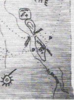
On that Tayopa Almacen Map, what is the name of the mine on the fourth line? It looks like CEUP-S. I can see "SONORA" Mine, "JOSE" Mine, "JAQUI" Mine, "TAYOPA" Mine, "CEUP-S" Mine, "CASANALE (CASANALO)" Mine, no name mine, "CHINIPAS" Mine.
Eleven (11) trails in all are shown:
1. Seven trails (eight mines on seven trails), are shown that meet up with
2. One Trail from Tayopa that goes to just shy of the Rio Grande
3. One Trail splits off to the North to the "Rabbit Eared Target"
4. One short Trail heads through what looks like Paloma Pass (PASAR), around to the East Side of the Caballos (looks like about the location of Bat Cave), or splits to the North to Apacheria
5. One Trail goes from East Side of Caballos NorthEast to Apacheria
6. One Trail leads South along the Rio Grande to Mexico. This is probably The Jornada del Muerto that passes the same area up to Apacheria (Santa Fe).
Although I posted 11 trails, but there are 12 in my counting, I think the directly South Trail and the trail from (Lower) Almacen to Apacheria are the same trail (Jornada del Muerto).
...... That map reads that a mule train would leave Tayopa Mission for a ten day trek NorthEast into Apacheria (Santa Fe, NM Area). I say ten days because of the Ten Rayed Sun with one ray pointing NorthEast. As they traveled, they had scheduled meeting points with representatives from each one of the seven (8) mines in the area. At each point, they would either take materials or let mules and men join their trail heading NorthEast. The main stopping point is the counting room somewhere North of the Gila Headwaters.
...........that is, of course, if this map is authentic.
Mike
sdcfia
Silver Member
- Sep 28, 2014
- 3,657
- 8,879
- Primary Interest:
- Other
Why would all these Jesuits lug all that gold so far north into a Franciscan/Spanish stronghold established in the 16th century? Also, how were they able to negotiate their way through the Apache groups who dominated southern NM during the same time period? While we're at it, how to you place "Apacheria" in the Santa Fe area? None of it makes sense.Don Jose,
On that Tayopa Almacen Map, what is the name of the mine on the fourth line? It looks like CEUP-S. I can see "SONORA" Mine, "JOSE" Mine, "JAQUI" Mine, "TAYOPA" Mine, "CEUP-S" Mine, "CASANALE (CASANALO)" Mine, no name mine, "CHINIPAS" Mine.
Eleven (11) trails in all are shown:
1. Seven trails (eight mines on seven trails), are shown that meet up with
2. One Trail from Tayopa that goes to just shy of the Rio Grande
3. One Trail splits off to the North to the "Rabbit Eared Target"
4. One short Trail heads through what looks like Paloma Pass (PASAR), around to the East Side of the Caballos (looks like about the location of Bat Cave), or splits to the North to Apacheria
5. One Trail goes from East Side of Caballos NorthEast to Apacheria
6. One Trail leads South along the Rio Grande to Mexico. This is probably The Jornada del Muerto that passes the same area up to Apacheria (Santa Fe).
Although I posted 11 trails, but there are 12 in my counting, I think the directly South Trail and the trail from (Lower) Almacen to Apacheria are the same trail (Jornada del Muerto).
...... That map reads that a mule train would leave Tayopa Mission for a ten day trek NorthEast into Apacheria (Santa Fe, NM Area). I say ten days because of the Ten Rayed Sun with one ray pointing NorthEast. As they traveled, they had scheduled meeting points with representatives from each one of the seven (8) mines in the area. At each point, they would either take materials or let mules and men join their trail heading NorthEast. The main stopping point is the counting room somewhere North of the Gila Headwaters.
...........that is, of course, if this map is authentic.
Mike
Real de Tayopa Tropical Tramp
Gold Member
Ah but it does. SDC 
gollum
Gold Member
- Jan 2, 2006
- 6,729
- 7,596
- Detector(s) used
- Minelab SD2200D (Modded)/ Whites GMT 24k / Fisher FX-3 / Fisher Gold Bug II / Fisher Gemini / Schiebel MIMID / Falcon MD-20
- Primary Interest:
- All Treasure Hunting
Don Jose,
It does to us, but since it is at odds with SDC's Theory, it doesn't make sense.
SDCFIA,
FIRST: We have to keep one important thing in mind. The last sentence of my post "........that is, of course, if this map is authentic." HAHAHA
That said, lets look at your question; "Why would all these Jesuits lug all that gold so far north into a Franciscan/Spanish stronghold established in the 16th century?"
A: The Jesuits were hiding the gold from the Spaniards. Any wealth they wanted to send back to Rome or the Philippines could only be moved far away from most Spanish Civilization. That means going North before heading east to Matamoros on the Gulf Coast or West to Baja and load their wealth onto Manila Galleons. I used the term "APACHERIA" because on several of my period maps, the entire area is labelled "APACHES" of one type or another.

Some of the Apache Tribes were friendlier than others. The Jesuits and Franciscans are both members of the Catholic Church FIRST, and subjects of the Kings/Queens of whatever lands they were in SECOND. I would be willing to bet dollars to donuts The Franciscans would have worked with The Jesuits and not rat them out to the Spanish.
Mike
It does to us, but since it is at odds with SDC's Theory, it doesn't make sense.
SDCFIA,
FIRST: We have to keep one important thing in mind. The last sentence of my post "........that is, of course, if this map is authentic." HAHAHA
That said, lets look at your question; "Why would all these Jesuits lug all that gold so far north into a Franciscan/Spanish stronghold established in the 16th century?"
A: The Jesuits were hiding the gold from the Spaniards. Any wealth they wanted to send back to Rome or the Philippines could only be moved far away from most Spanish Civilization. That means going North before heading east to Matamoros on the Gulf Coast or West to Baja and load their wealth onto Manila Galleons. I used the term "APACHERIA" because on several of my period maps, the entire area is labelled "APACHES" of one type or another.
Some of the Apache Tribes were friendlier than others. The Jesuits and Franciscans are both members of the Catholic Church FIRST, and subjects of the Kings/Queens of whatever lands they were in SECOND. I would be willing to bet dollars to donuts The Franciscans would have worked with The Jesuits and not rat them out to the Spanish.
Mike
Real de Tayopa Tropical Tramp
Gold Member
love the map Mike.
At that time, almost the entire region could be called Apache land.It was a matter of arranging a deal with the prevailing tribe. And as you mentioned, there was a certain amount of co-operation between the Jesuits, the Franciscans, and the Apache - after all, the Apache were basically business men. Of course, as usual, there were a few broncos.
As for going north a few more kilometers, it was in exchange for a cheaper and easier travel of 'Rio del Norte, which accounted for the 'major distance' to a shipping port.
The Jesuits were not fools, they had a valid reason for each move.
Chosing the Caballos and Victorio Peak also fit into their plans. As at Tayopa they used a series of natural faultings and voids to form their deposits.
Ordinarily using only mule trains to load a ship would take too much time. so a holding depository inland - far better security - that is situated on a major, navigable, waterway, makes sense. By using the river they coud fill a ship far quicker, cheaper,and with less exposure.
Last edited:
sdcfia
Silver Member
- Sep 28, 2014
- 3,657
- 8,879
- Primary Interest:
- Other
I'll see your HAHAHA and raise it to Bwa-ha-ha.SDCFIA,
FIRST: We have to keep one important thing in mind. The last sentence of my post "........that is, of course, if this map is authentic." HAHAHA
That said, lets look at your question; "Why would all these Jesuits lug all that gold so far north into a Franciscan/Spanish stronghold established in the 16th century?"
A: The Jesuits were hiding the gold from the Spaniards. Any wealth they wanted to send back to Rome or the Philippines could only be moved far away from most Spanish Civilization. That means going North before heading east to Matamoros on the Gulf Coast or West to Baja and load their wealth onto Manila Galleons. I used the term "APACHERIA" because on several of my period maps, the entire area is labelled "APACHES" of one type or another.
Some of the Apache Tribes were friendlier than others. The Jesuits and Franciscans are both members of the Catholic Church FIRST, and subjects of the Kings/Queens of whatever lands they were in SECOND. I would be willing to bet dollars to donuts The Franciscans would have worked with The Jesuits and not rat them out to the Spanish.
Mike
Hiding from the Spanish - exactly. We've been down this road before. Several times. For those interested in the facts: http://www.treasurenet.com/forums/j...asures-they-real-post4564647.html#post4564647
I'm surprised - you usually demand a stronger argument to support these sorts of speculations. Well, I guess you might win a few donuts if you want to write an historical treasure tale novel where this theory works.
Tropical Tramp, why are you putting the cart before the horse with this Caballo-Jesuit speculation, especially when your argument is based on that "map", which allegedly comes from the camp of the Babe Ruth of the fraud world? Tsk, tsk. I hope your evidence for the existence of the "Tayopa" is more convincing.
Ponchosportal
Full Member
- Nov 19, 2004
- 234
- 251
- Primary Interest:
- Other
love the map Mike.
At that time, almost the entire region could be called Apache land.It was a matter of arranging a deal with the prevailing tribe. And as you mentioned, there was a certain amount of co-operation between the Jesuits, the Franciscans, and the Apache - after all, the Apache were basically business men. Of course, as usual, there were a few broncos.
As for going north a few more kilometers, it was in exchange for a cheaper and easier travel of 'Rio del Norte, which accounted for the 'major distance' to a shipping port.
The Jesuits were not fools, they had a valid reason for each move.
Chosing the Caballos and Victorio Peak also fit into their plans. As at Tayopa they used a series of natural faultings and voids to form their deposits.
Ordinarily using only mule trains to load a ship would take too much time. so a holding depository inland - far better security - that is situated on a major, navigable, waterway, makes sense. By using the river they coud fill a ship far quicker, cheaper,and with less exposure.
Seems like the would have moved an awful lot of gold bars/ore/etc. through an area (Caballos and Victorio Peak) which must have had a lot of the type of people (spanish/mexicans/etc.) looking for the materials. How did they accomplish this without being identified/found out?
Real de Tayopa Tropical Tramp
Gold Member
Sdc,
That lil map supposedly came from the Noss fmily. It was recovered / produced by them in the 20 or 30's. It contains correct information that wasn't known until the 90's. There is no way the Noss family - or others - could have known this. It also follows the modus Operendi of the period. I see nothing that even hints otherwise.
The 18-- date on the map hasn't been clarified yet, only postulated, still open.
Putting them togethr, I am convinced that it is genuine. Of course I am always open to change. There have been 'many' in the search for Tayopa.
Last edited:
Real de Tayopa Tropical Tramp
Gold Member
Ponchas portal
I can only postulate. Also I do remember a movement of almost million men in operation 'Overlord' where the enemy was taken completely by surprise.
Where's there is a will there is a way.
Bribery / deep pockets can do wonders.
I can only postulate. Also I do remember a movement of almost million men in operation 'Overlord' where the enemy was taken completely by surprise.
Where's there is a will there is a way.
Bribery / deep pockets can do wonders.
Last edited:
Oroblanco
Gold Member
- Jan 21, 2005
- 7,838
- 9,830
- Detector(s) used
- Tesoro Lobo Supertraq, (95%) Garrett Scorpion (5%)
Sdc,
That lil map supposedly came from the Noss fmily. It was recovered / produced by them in the 20 or 30's. It contains correct information that wasn't known until the 90's. There is no way the Noss family - or others - could have known this. It also follows the modus Operendi of the period. I see nothing that even hints otherwise.
The 18-- date on the map hasn't been clarified yet, only postulated, still open.
Putting them togethr, I am convinced that it is genuine. Of course I am always open to change. There have been 'many' in the search for Tayopa.
Can you explain why the Jesuits would decide to pack treasures well north, across the hostile Apache territory, into Franciscan territory, for a "shorter" route - when the Jesuits had their own ship operating in the Pacific, sailing right along with the famous Manila galleons? No one to report to or even question what was being loaded or unloaded. Plus a fair amount of the profits from Mexico were being used to support and finance their operations in the Far East, especially Japan. There was also an encounter reported with a train of pack mules loaded with silver, headed for a secret embarkation point on the Pacific coast. Do you know of any similar report of a shipment being encountered along the Caballos route?
That 'lil map' is still pretty questionable - we just don't really know who made it or when. The info you seem to see as proof that it is genuine, may have been added since 1990s or very recently.
Thanks in advance;
Oroblanco

Rawhide
Silver Member
- Nov 17, 2010
- 3,590
- 2,185
- Detector(s) used
- Nox 800, Etrac, F75, AT Pro. Last two for sale.
- Primary Interest:
- All Treasure Hunting
Im looking at the map and just thinking out loud here. If you look at the word Caballos, then look at the mine sign below. It looks like a claimed area already. I dont think the mine owner really knows what he has. But if you look closely, there is more than one hole or pit. The heart/fox looking marking does resemble a area I have been wanting to hike. I lost my invitation to the area and dont know who has what claimed up, so I dont go. I do know a lot of the area has been cleansed of sign on purpose. Paranoia abounds in that area. I do agree doc noss cache is on there also. Shame folks dont work together anymore.
Real de Tayopa Tropical Tramp
Gold Member
Oro, what you sy is also true, some was shipped, to the Orient, but the bulk went to Rome.
On the 'lil' map, it's true that it could have been added after te 1990 date, but for what purpose ?
N P. can we ask you when you acquired that lil map ?
On the 'lil' map, it's true that it could have been added after te 1990 date, but for what purpose ?
N P. can we ask you when you acquired that lil map ?
Oroblanco
Gold Member
- Jan 21, 2005
- 7,838
- 9,830
- Detector(s) used
- Tesoro Lobo Supertraq, (95%) Garrett Scorpion (5%)
Oro, what you sy is also true, some was shipped, to the Orient, but the bulk went to Rome.
On the 'lil' map, it's true that it could have been added after te 1990 date, but for what purpose ?
N P. can we ask you when you acquired that lil map ?
I remembered the name of the Spanish explorer that accidently ran into a pack train of mules (no ox carts) in 1603 heading for the Pacific coast apparently in secret, it was Vizcaino. I am not convinced that the Jesuits were shipping their silver and gold across the Atlantic route, especially when they went to such lengths to set up a method to ship the long way around via the Pacific. The advantages of that route are rather surprising, like less chances of encounters with pirates (for quite some time) and less encounters with Spanish governmental officials.
It just doesn't make sense to me, for them to have packed heavy silver and gold bullion from Tayopa all that distance across mountains and through hostile Indians to hide it in Franciscan territory. Also, some of the items found (or reported found) by Noss in VP appear to post date the Jesuit times. Besides, the Tayopa Inventory document would not make sense, if the treasures were simply being shipped out to another hiding place so far away. That inventory document implies that the amassed treasures from the Tayopa mines, was being stored right at Tayopa - not far away in New Mexico.
Sorry for getting off topic there a bit, please do continue.
Ponchosportal
Full Member
- Nov 19, 2004
- 234
- 251
- Primary Interest:
- Other
Ponchas portal
I can only postulate. Also I do remember a movement of almost million men in operation 'Overlord' where the enemy was taken completely by surprise.
Where's there is a will there is a way.
Bribery / deep pockets can do wonders.
Even with bribery and deep pockets it seems that the suggestion is that the movement was occurring on a regular/periodic frequency. Also I am assuming it was a significant volume (heavy) I.e. needs a lot of energy, time, secrecy, distraction, and .......... just seems like if anyone saw you doing anything back there/then the first question to come to mind is "What the hell are they doing here .....? I would think people had a lot of curiosity about everything and anything out there back then.
Thank you for your response and perspective Real,
Poncho
Top Member Reactions
-
 2354
2354 -
 1126
1126 -
 1054
1054 -
 891
891 -
 823
823 -
 795
795 -
 756
756 -
 752
752 -
 607
607 -
 500
500 -
 490
490 -
 473
473 -
 465
465 -
 423
423 -
 390
390 -
 383
383 -
 382
382 -
 381
381 -
O
379
-
 378
378
Users who are viewing this thread
Total: 2 (members: 0, guests: 2)


