Old Bookaroo
Silver Member
- Dec 4, 2008
- 4,318
- 3,510
Friends:
This really is more about the entire Southwest than Vicky Peak. However, I think significant clues to the mystery might be found here.
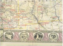
This is an excerpt from the National Geographic map The Southwestern United States - it was laid into the June 1940 issue.
It has hundreds of references to historic events including Indian fights and skirmishes, trails, natural features, and more.
I've been picking up copies for a few bucks when I see them. But there's no reason to be greedy so I'm sharing the resource.
If you find a copy for sale make sure it isn't faded as the essential features for treasure hunters are printed in red - and that is the first color to be destroyed by the sun.
Good luck to all,
The Old Bookaroo
Amazon Forum Fav 👍
Last edited:


