Rebecca Taggart, Phantom of the Caballos

Not Peralta

Bronze Member
Mar 23, 2013
2,167
3,061
Primary Interest:
All Treasure Hunting

BIGSCOTT

Hero Member
Jul 19, 2013
723
703
spring texas
Detector(s) used
fisher 1265
Primary Interest:
Prospecting
And even though they were rich and many others in the area were also, they all showed signs of ancient workings.

Got rain here for a couple of days, gonna go to the library and find the best Bio I can on FDR, see if I can find anything
about his mining ventures, the man he took office from Herbert Hoover was one of the greatest mining engineer's the
world has ever Known, and an all around great american.

In the words of the late great Archie Bunker
''Mister we could use a man like Herbert Hoover again''
 

BIGSCOTT

Hero Member
Jul 19, 2013
723
703
spring texas
Detector(s) used
fisher 1265
Primary Interest:
Prospecting
Back then if you lived in spain, and wanted to go to the new world the number one requirement was
to read de re metalica.

it covers every thing from spotting mineral deposits, assay's smelting, and many purifacation methods
still used today.
 

OP
OP
HarryLime

HarryLime

Greenie
Oct 29, 2015
15
30
Levelland, Texas
Primary Interest:
Cache Hunting
I'm going to see if I can find a copy of Hoover's translation of De Re Metalica on Amazon. Sounds like an interesting book--I remember hearing that it talks about the lights associated with buried gold, etc.

Bigscott, was it the Joseph Cummins book where you learned that info about Rebecca and the cave with skeletons? I haven't had a chance to read all of the Cummins book yet--I'm busy running a module builder, helping my brother and dad strip cotton, so I don't get home till late these days.
 

OP
OP
HarryLime

HarryLime

Greenie
Oct 29, 2015
15
30
Levelland, Texas
Primary Interest:
Cache Hunting
Oroblanco? Good to know. I was just reading through his thread about bigfoot sightings. He's one of the most interesting posters on this site.
 

adtofca

Banned
Jan 22, 2016
88
102
California Sun
Detector(s) used
minelab thingy
Primary Interest:
All Treasure Hunting
lights are always visible around the mountains in new mexico and arizona but the best i have seen is in california by Searchlight on the Nevada
state line . they glow greenish blue and they look like baby kittens chasing each other when they play .
 

gollum

Gold Member
Jan 2, 2006
6,729
7,594
Arizona Vagrant
Detector(s) used
Minelab SD2200D (Modded)/ Whites GMT 24k / Fisher FX-3 / Fisher Gold Bug II / Fisher Gemini / Schiebel MIMID / Falcon MD-20
Primary Interest:
All Treasure Hunting
When I was researching Rebecca Taggart, I found several newspaper articles from the early 1930s saying how a man had married the daughter of Porfirio Diaz who had an ancient map that would guide them to the Caballo Mountains. Got to be the same folks.

Mike
 

BIGSCOTT

Hero Member
Jul 19, 2013
723
703
spring texas
Detector(s) used
fisher 1265
Primary Interest:
Prospecting
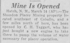
img.jpg this article says the Shandon placers are southeast of caballo, so probably not the same ones NP is talking about,
but this is in 1929 Charles Taggart is trying to find a way to make some sort of pay, by this time he had been looking for the treasure cave many years,
these placers are probably under Caballo lake now.
 

BIGSCOTT

Hero Member
Jul 19, 2013
723
703
spring texas
Detector(s) used
fisher 1265
Primary Interest:
Prospecting
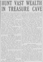
I have heard that charles was in the Caballo's as early as 1920 maybe even a little earlier, here is an article GARRY found from 1926
and it does not look like Charles and Rebbeca are married yet. img-1.jpg
 

BIGSCOTT

Hero Member
Jul 19, 2013
723
703
spring texas
Detector(s) used
fisher 1265
Primary Interest:
Prospecting
Also I told HarryLime that I read the story about Rebbeca Taggart finding in ''Lure of the Caballo's'' this may be true but if found another reference to it
cant find much else by this lady but i am now sure that her writtings were the first time i heard the Margaret Perrone story, if you remember I said the first telling
I heard her name was not Perrone, that is because this lady calls her ''Lady M''.
This womens name was Ruth B Tolman she was a phsycologist and socialite, she studied and wrote about social habits, criminal habits, also wrote some books
on young ladys edicut, she was married to one of the physacist that worked on the first atom bomb north of the San Andreas, she had a long running affair
with J Oppenhimmer, considered the father of the atomic bomb, their affair was public Knowledge even to both their spouses and lasted after her husband died.
Why she conducted these interviews I dont know, maybe studying the warped mind of us treasure hunters, maybe just got bored hangin with Albert Einstine
in most cases she only uses the people's initials, but some like Rebbeca Taggart she uses their full name, these interviews were never in a book under her name
but were included in the chapter of a book, and i cant remember the name, but there are a couple in 100 tons of gold
 

sdcfia

Silver Member
Sep 28, 2014
3,654
8,870
Primary Interest:
Other
View attachment 1279883 this article says the Shandon placers are southeast of caballo, so probably not the same ones NP is talking about,
but this is in 1929 Charles Taggart is trying to find a way to make some sort of pay, by this time he had been looking for the treasure cave many years,
these placers are probably under Caballo lake now.

When I moved to Silver City in the 70s, a pretty successful old mining man named Johnston (sp?) had placer claims in an historic district southeast of Caballo Reservoir. These claims were east of the river. He gave up on the Caballos because, as I recall he said, "The place is infested with criminals and crazies. I've been shot at on my own claims!"
 

sdcfia

Silver Member
Sep 28, 2014
3,654
8,870
Primary Interest:
Other
I have heard that charles was in the Caballo's as early as 1920 maybe even a little earlier, here is an article GARRY found from 1926
and it does not look like Charles and Rebbeca are married yet. View attachment 1279892

There are three messages in this typical sensational newspaper "treasure article" that are of interest. First, the Diaz connection. Second, the mention of activities 50 years prior (to 1926). Third, the mention of activities 10 years prior (to 1926).

The "Pedro Navarrez Caballos confession" was shown to be total bs a year or so ago - detailed in a post of mine somewhere in one of these VP threads. As I recall the details (which anyone could have found for themselves with a simple Google search), Navarrez never set foot in NM, but was quite active in Mexico, where he was caught and hung. He buried his loot on the family ranch. His daughter confirmed the whole thing.
 

whiskeyrat

Hero Member
May 7, 2012
539
1,246
mid Michigan
Primary Interest:
Prospecting
There are three messages in this typical sensational newspaper "treasure article" that are of interest. First, the Diaz connection. Second, the mention of activities 50 years prior (to 1926). Third, the mention of activities 10 years prior (to 1926).

The "Pedro Navarrez Caballos confession" was shown to be total bs a year or so ago - detailed in a post of mine somewhere in one of these VP threads. As I recall the details (which anyone could have found for themselves with a simple Google search), Navarrez never set foot in NM, but was quite active in Mexico, where he was caught and hung. He buried his loot on the family ranch. His daughter confirmed the whole thing.

Dang it. You mean that 80 mule loads of silver i found yesterday is not Pedro's??
I guess i will just go put it back.
wr
 

Garry

Sr. Member
Apr 19, 2009
256
496
All

We were in Truth or Consequences last month for a couple of days and, among other things, my wife and I spent some time trying to get our bearings regarding some of the Caballo’s treasure stories. We didn’t get far and obviously needed help.

The simplest question we had was how do you get from the towns on the west side of the Rio Grande to the east side and the foothills of the Caballo Mountains with an automobile. We asked a gentleman in a campground and he told us there were three ways to cross the river between T or C and Arrey. We knew about the bridge at Elephant Dam on the road to Engle and we found the bridge northeast of Arrey but he also mentioned a road out of Las Palomas that I assume leads to the Palomas gap road.

We were south of Palomas and he told us to go north on 187 and upon crossing the bridge at Palomas Creek take a right. I think we were on the correct road but after about a mile of traveling east, we hit a T and although we checked in both directions, we didn’t find any road leading to the river. We didn’t understand how there would have been an unmapped crossing there anyway but we thought maybe it was a low water crossing?

Is the 4W Palomas Gap road still passable?

Joseph Cummins suggested in his book that there was a passage through the Caballo’s via Apache Gap at one time. Does a 4W road still exist that is passable over the mountains or did one ever exist?

We don’t know when the two present bridges were built but how did the early miners and mining operations move across the west side of the river with equipment to the western foothills of the Caballos?

I also have some questions regarding access to the eastern side of the Caballos but will save them.

We spent more of our time in the Sierra County, Clerk’s Office looking for Taggart related documents and eventually I would love to get some GPS locations for some of the shafts/tunnels that the Taggarts dug. I hope someone has something along those lines.

Thanks in advance for any help!

Garry
 

whiskeyrat

Hero Member
May 7, 2012
539
1,246
mid Michigan
Primary Interest:
Prospecting
All

We were in Truth or Consequences last month for a couple of days and, among other things, my wife and I spent some time trying to get our bearings regarding some of the Caballo’s treasure stories. We didn’t get far and obviously needed help.

The simplest question we had was how do you get from the towns on the west side of the Rio Grande to the east side and the foothills of the Caballo Mountains with an automobile. We asked a gentleman in a campground and he told us there were three ways to cross the river between T or C and Arrey. We knew about the bridge at Elephant Dam on the road to Engle and we found the bridge northeast of Arrey but he also mentioned a road out of Las Palomas that I assume leads to the Palomas gap road.

We were south of Palomas and he told us to go north on 187 and upon crossing the bridge at Palomas Creek take a right. I think we were on the correct road but after about a mile of traveling east, we hit a T and although we checked in both directions, we didn’t find any road leading to the river. We didn’t understand how there would have been an unmapped crossing there anyway but we thought maybe it was a low water crossing?

Is the 4W Palomas Gap road still passable?

Joseph Cummins suggested in his book that there was a passage through the Caballo’s via Apache Gap at one time. Does a 4W road still exist that is passable over the mountains or did one ever exist?

We don’t know when the two present bridges were built but how did the early miners and mining operations move across the west side of the river with equipment to the western foothills of the Caballos?

I also have some questions regarding access to the eastern side of the Caballos but will save them.

We spent more of our time in the Sierra County, Clerk’s Office looking for Taggart related documents and eventually I would love to get some GPS locations for some of the shafts/tunnels that the Taggarts dug. I hope someone has something along those lines.

Thanks in advance for any help!

Garry

The road you mention just north of Polomas creek does continue past that "T" that you came to. Its not really on maps, even most topo maps dont show it.
Its not really a road, just a dirt trail that winds its way down to the river, then follows the river south for a mile or so and eventually does cross the river at a shallow water crossing.
It brings you up to the Caballos somewhere near longbottom canyon.
Definitely 4wd only.

wr
 

whiskeyrat

Hero Member
May 7, 2012
539
1,246
mid Michigan
Primary Interest:
Prospecting
All

We were in Truth or Consequences last month for a couple of days and, among other things, my wife and I spent some time trying to get our bearings regarding some of the Caballo’s treasure stories. We didn’t get far and obviously needed help.

The simplest question we had was how do you get from the towns on the west side of the Rio Grande to the east side and the foothills of the Caballo Mountains with an automobile. We asked a gentleman in a campground and he told us there were three ways to cross the river between T or C and Arrey. We knew about the bridge at Elephant Dam on the road to Engle and we found the bridge northeast of Arrey but he also mentioned a road out of Las Palomas that I assume leads to the Palomas gap road.

We were south of Palomas and he told us to go north on 187 and upon crossing the bridge at Palomas Creek take a right. I think we were on the correct road but after about a mile of traveling east, we hit a T and although we checked in both directions, we didn’t find any road leading to the river. We didn’t understand how there would have been an unmapped crossing there anyway but we thought maybe it was a low water crossing?

Is the 4W Palomas Gap road still passable?

Joseph Cummins suggested in his book that there was a passage through the Caballo’s via Apache Gap at one time. Does a 4W road still exist that is passable over the mountains or did one ever exist?

We don’t know when the two present bridges were built but how did the early miners and mining operations move across the west side of the river with equipment to the western foothills of the Caballos?

I also have some questions regarding access to the eastern side of the Caballos but will save them.

We spent more of our time in the Sierra County, Clerk’s Office looking for Taggart related documents and eventually I would love to get some GPS locations for some of the shafts/tunnels that the Taggarts dug. I hope someone has something along those lines.

Thanks in advance for any help!

Garry

The 4wd Polomas Gap road is still passable in a well equipped jeep or 4wd quad only in my opinion.
I went thru Polomas Gap last month with my Sportsman quad and it was a challenge to say the least.
I went from east to west.
The "roads" shown on topo maps are not very accurate anymore. Many of them have been washed away and "work arounds" are required by using other 4wd trails.
After a few attempts I was able to find my way thru the gap. Worth the effort just to experience the "road".
Live GPS positioning was valuable due to having to take so many detours onto other trails and then work your way back to the gap road.
wr
 

whiskeyrat

Hero Member
May 7, 2012
539
1,246
mid Michigan
Primary Interest:
Prospecting
All

We were in Truth or Consequences last month for a couple of days and, among other things, my wife and I spent some time trying to get our bearings regarding some of the Caballo’s treasure stories. We didn’t get far and obviously needed help.

The simplest question we had was how do you get from the towns on the west side of the Rio Grande to the east side and the foothills of the Caballo Mountains with an automobile. We asked a gentleman in a campground and he told us there were three ways to cross the river between T or C and Arrey. We knew about the bridge at Elephant Dam on the road to Engle and we found the bridge northeast of Arrey but he also mentioned a road out of Las Palomas that I assume leads to the Palomas gap road.

We were south of Palomas and he told us to go north on 187 and upon crossing the bridge at Palomas Creek take a right. I think we were on the correct road but after about a mile of traveling east, we hit a T and although we checked in both directions, we didn’t find any road leading to the river. We didn’t understand how there would have been an unmapped crossing there anyway but we thought maybe it was a low water crossing?

Is the 4W Palomas Gap road still passable?

Joseph Cummins suggested in his book that there was a passage through the Caballo’s via Apache Gap at one time. Does a 4W road still exist that is passable over the mountains or did one ever exist?

We don’t know when the two present bridges were built but how did the early miners and mining operations move across the west side of the river with equipment to the western foothills of the Caballos?

I also have some questions regarding access to the eastern side of the Caballos but will save them.

We spent more of our time in the Sierra County, Clerk’s Office looking for Taggart related documents and eventually I would love to get some GPS locations for some of the shafts/tunnels that the Taggarts dug. I hope someone has something along those lines.

Thanks in advance for any help!

Garry

The Apache gap "road" is even more challenging than the Palomas gap "road".
I attempted it from west to east.
It starts out relatively easy going. But just beyond the "waterfall" the main road turns south and heads down to garfield area. that road is easy.
the road thru polomas turns north at this point and immediately begins to deteriorate.
I turned back about 1.25 miles from making it "thru the gap" on the east end.
The road was so punishing that it was not worth the risk to continue.
Breaking an axle that far in would not be fun.
I was on an extremely capable 4wd quad that I have taken most anywhere you can imagine and I turned around just short of going thru.
There were tracks evident thru and over the rocks, but it must have been very capable jeep or quads equipped for rock climbing.
In my opinion, its no longer a passable road unless you just want to challenge yourself and your vehicle.

wr
 

Top Member Reactions

Users who are viewing this thread

Top