Pedro Navarez in Caballo Mountains or Organ Mountains????

Feb 9, 2019
138
230
Primary Interest:
All Treasure Hunting
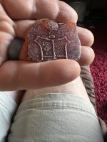
Cache where Silver Bars were Hidden , I'll show the Glyphs that Guided to this deposit later .

Silver Bar Deposit recovered.JPG
 

Feb 9, 2019
138
230
Primary Interest:
All Treasure Hunting
Marker Pointer Stone on Boulder with Glyph that Represents Stacked Stones over a Deposit .

I advise that no one attempt to make a Recovery .

it may be against a few Laws .

if you try to recover anything I post , you the reader did so against my advice and of your own volition .


Chato Treasure Pointer and Stacked Stone Seal.JPG
 

Feb 9, 2019
138
230
Primary Interest:
All Treasure Hunting
Between the two Boulders in above Photo , can be found Four connected Triangles .

and this Heart Symbol .


Heart Symbol to Silver Bars.JPG
 

Feb 9, 2019
138
230
Primary Interest:
All Treasure Hunting
Sorry , wrong Heart , that symbol is the Heart that Directs us to the Big Heart Symbol .

This looks Interesting too

This is the Dog Man Head Boulder , site #3 .

not a good shot , but you can make out his Eye and Notched Mouth .

a Better Photo will be Posted later .

Dog Man Head Boulder with Tunnel into Cave Beneath it.JPG
 

Feb 9, 2019
138
230
Primary Interest:
All Treasure Hunting
Dragon Symbol that many Mistake as Aztec .

Nope , it is like so many of the Glyphs , a Profile of a Rock Formation that is staring at another concealed Treasure site .

Oddities Dragon.JPG
 

Feb 9, 2019
138
230
Primary Interest:
All Treasure Hunting
The Entrance to the Silver Mine with the Smelter inside .
This is a Vertical Shaft , Dangerous , so please avoid any attempt to enter this shaft


I will show the Symbol that depicts it's location


Entrance into Vertical Mine.JPG
 

Feb 9, 2019
138
230
Primary Interest:
All Treasure Hunting
From the Map Rock at Chato's site #1
Standing and looking at the Symbol for the Mine Shaft , if you look over this Map Rock , you can see the Rock Formation
that it is in .

The Zig Zag Line with double lines extending either side .

Those Double lines represent side Niches ( Caves for Storage of Bars and Tools )

El Chato Script 072.JPG
 

Feb 9, 2019
138
230
Primary Interest:
All Treasure Hunting
Red Circles shows trail to each side of the Mountain , Left " Where the Sun Sets " Right " where the Sun Rises .
to the right is the symbol to represent the Vertical Mine Shaft .

here's a close up of that Symbol , by the way , this is the Silver Mine and Smelter , The Gold Mine is with sight of this .

OOOps , sorry , the image loader just went wonkey on this Page .
 

UncleMatt

Bronze Member
Jul 14, 2012
2,389
2,530
Albuqerque, NM / Durango, CO
Detector(s) used
Garrett Infinium & Gold Bug II, Bazooka Super Prospector Sluice
Primary Interest:
All Treasure Hunting
I meant for claims like this:

"1996 , a research team entered the Cookes Range with a Copy of the Original 1650 Pedro Navarez Document .
That Copy was found beneath the Podium of a small Mission in Northern Mexico .
The Copy was made from the Original and sent North to that Mission ."

As always I am more than happy to seriously consider any evidence presented, as long as I am afforded the opportunity to look at the evidence myself. Is there a copy of this Navarez Document that can be posted here? Or accessed in a peer reviewed study?
 

Feb 9, 2019
138
230
Primary Interest:
All Treasure Hunting
Ok , a question was asked , Directions to the site #1 Petroglyphs .

Take sr 26 off 180 north out of Deming , at the 5 mile post , watch for Ranch House set 70 yards off to your Left
and Street Sign for Green Leaf Mine Rd.

Stay on that Road for 5 miles to the 3rd Earthen Berm you encounter , pull off to your Left before the Square Ponding area .
Park just below the Stone Bluff , find Trail that takes up the side of the Berm and head up until you top out on Level Ground .

Petroglyph Map Rock is about center of the area , to your left of the Trail with small very green trees growing beside it , it's a low
profile stone .

There are more Glyphs spread around up there to the left and right of the Map Rock .


To site Number Two and the Silver Mine .

Return the direction you approached until you come to a Cattle Guard ( the last one you past in coming )

Turn to your left at that Cattle Guard , stay to the Right as you reach the first fork in the Road , follow the Road , open close gates as you come to them .
You will come to another Berm with a large Steel Cattle Feed trough , you just went 65 feet to far , return and find a Sign for Wilderness study area
on your Right , ( High Clearance vehicles from this point on )
Take that Road up the Slope and top out , follow the Road for 7/10ths of a Mile and watch for a Stacked Stone Cairn on your right
at a small Two Track Road that runs about 5 yards to a slope .
Stop and Park there at a Larger Hand Stacked Stone Cairn , Look over it across the Basin and you will see a narrow Mouth Canyon with
a Large Yellow Boulder to the right , and a Square sided Rock Out Cropping on it's Left .

The Silver Mine is within a Crack in that Out Cropping . do not attempt to remove any of the Cap Stones blocking the Entrance .

You will see the Slag Pile , go up the trail along side of it , go into the Crack , at the entrance of the Crack are Inscribed Thee Spanish Crosses .

Go back down to the Large yellow Boulder and walk aloong the Cattle trail toward the Head of the Canyon , watch for Glyphs on the Boulders you come to .

There are Hundreds of them .
Enjoy the Day as you explore the Glyphs .

Site #3 ,
at about 3.7 miles from sr26 , watch to your right for a Road that Takes you on top of the Earthen Berm . Again , stay to the right at the first Fork
in the Road , Follow it to the Gate , open close gate behind you please .

Follow Road to a Big Berm where you will encounter Two Brand New Black Plastic Water Tanks , go around those and up over the Other side
of the Berm , within 40 yards you will find the Wilderness signs again , Park on left and Follow Trails up to the BIG Boulders .
You will encounter Matate' Holes along the way , many Glyphs , some Trail Maps for the The Tribes that came to Trade with each other here
at this site .

I will post Google Earth Photos of the Route if you need and ask .

Ok , I have over two hundred Photos of these sites that I can Post , or if if you like and are Local , I will give further Directions to
all sites in the Cookes Range .

El Chato Script 025.JPG
 

Feb 9, 2019
138
230
Primary Interest:
All Treasure Hunting
In time , all questions will be answered as the presentation evolves . For now , I will simply post Photos and describe meaning
of the Glyphs , along with Location of the Gold Mine and a Few of the Secured Deposits .
Thank you .
 

sdcfia

Silver Member
Sep 28, 2014
3,648
8,864
Primary Interest:
Other
Those are interesting photos ECT. Looks like you started at PH and moved on to the other sites. Some of those dug out holes look like the places we call Mine 5 and Mine 6, but it's hard to say for certain. Your Recovery Site (Posts 17 and 18) are definitely what we call Mine 7 at FPC. My pics below from 2002 show that conditions are identical as yours, time stamped 1/28/2019. As you say, these sites are monitored by the BLM and any digging would likely be a mistake. By the way, your true initials wouldn't happen to be RA or RS would they?

Covered up 3.JPG Covered up 2.JPG

You mentioned vandals destroying glyphs. I hope this one is still intact in front of the Recovery Site. It's one of my favorites, artistically at least. I also like Jaguar Man and Posiedon. Who do you think those vandals were?
Totonteac-5.JPG jaguar man.jpg Poseidon.JPG

I'm curious about the documents you mentioned and their alleged tie to Navarrez. My exploring partner and I recently discussed heading back to the Cookes Range to check out places still on our list. It's an intriguing place.
 

sdcfia

Silver Member
Sep 28, 2014
3,648
8,864
Primary Interest:
Other
I meant for claims like this:

"1996 , a research team entered the Cookes Range with a Copy of the Original 1650 Pedro Navarez Document .
That Copy was found beneath the Podium of a small Mission in Northern Mexico .
The Copy was made from the Original and sent North to that Mission ."

As always I am more than happy to seriously consider any evidence presented, as long as I am afforded the opportunity to look at the evidence myself. Is there a copy of this Navarez Document that can be posted here? Or accessed in a peer reviewed study?

Reasonable request, Unc. I may be mistaken, but I believe I know who was on that "team" in the 1990s. If I'm correct, these were the proteges of the man who originally obtained information (a letter, maps and more) in the early 1980s and worked solo for some years. This man died in 1995 and I got my information directly from him ca 1984. I don't know why, but his stories differed from the "team's" later tellings, most of which were provided in open public meetings beginning in 1997. My opinion remains that the "team" either altered the original information given to them by the man who died in 1995, or were themselves not told the entire truth by him.

In any event, I can attest that ECT is well-informed about sites in the Cookes Range. I provided GPS coordinates for these sites in 2013, and I'm sure ECT's map will make it easy for interested folks to find them. I too hope more is revealed, particularly about the alleged documentation.
 

Last edited:

UncleMatt

Bronze Member
Jul 14, 2012
2,389
2,530
Albuqerque, NM / Durango, CO
Detector(s) used
Garrett Infinium & Gold Bug II, Bazooka Super Prospector Sluice
Primary Interest:
All Treasure Hunting
I await citations and presentations of evidence on this. I'm not really interested in interpretations by those who have failed to provide a basis or underlying foundation of their claims. You can find petroglyphs all over place, and their meaning is not known as a matter of fact, only how the observer chooses to interpret them. This isn't my first rodeo, and many people over the years have come and gone with stories and claims that sounded good to willing ears, but could never be substantiated in a meaningful way.

And just to be clear, as always, I would LOVE IT, if someone could prove any of the folklore tales in the SW to be true. I would LOVE IT to see someone's research turn into real world finds. So far though, that hasn't come close to happening, whether we are talking about NOSS' claims, Spanish legends, etc.
 

Feb 9, 2019
138
230
Primary Interest:
All Treasure Hunting
there will be questions , and I should have began with time line events .
1958 , our friend Cap.t F and group , entered a side Cavern , Cap't and Partner found exactly 2,179 Bars , exactly that amount as recorded
during the Gov.'t recovery .

This and several other recent recovery's , Triggered The N.S.A. and other parties that it may be fruitful to contact through Diplomacy ,
the Gov.'t of Spain for an offer of a split of future recoveries of what the N.S.A. Believed to be lost Spaniard Deposits .

Spain agreed to allow a U.S. Research Team to come and inspect Maps and Documents at the Archives of the Americas ,

The U.S. Team Filmed the Maps and Documents , Citizens who had fairly good Knowledge of the Targeted Mountains were incorporated
into the Team and sent in to scout out any Land Marks that were defined in the Documents .

( See posted Youtube Video of Interview with un-named individual that was a Member of that Team along with a Relative of mine , it's a Terry Carter
Video , posted in one of these VP Threads by Scdfia , He recounts the information led to a Mission in No. Mexico , where Documents were recovered
beneath the Podium , after the Satillo Tiles were removed , The Pedro Docs were i n those , The Docs were sent North to the Padre in hopes that his Parishioners would have knowledge of any Land Marks described in the Documents ,
That Padre is named on one of the Map Copies in one of these Threads , btw , The Seven Capt's
were not sent North with Loads of Treasure , those Seven Brigands were sent North to Capture and Destroy the Band of Indians and Pedro Navarez ,
It was and does represent a Military Action , some where in the amount of between 200 and 400 lives were lost in Pedro's 10 year Defense
of The Indians and their Lands against the Spaniards , The Governor of Mexico was under pressure to alleviate the situation , Ergo , the Calling up
of all Seven Brigands and to Purpose them to seek out and eliminate El Chato and Tribe )

Now Roll Forward a bit , during times of Drought , and other problems , Redacted portions of the El Chato Papers would be handed to certain
Parishioners in the same manner and same reason , by Priest of Various Missions , The hope was the same as well , that one of them may Recognize
the Land marks , where as , the Church would investigate further , and attempt Recovery if the Pot was Hot .

The Mistakes :

Reason that these deposits set up until now is the simple Mistakes people make in reviewing Pedro's waybill .

Caballo Peak , not Mountain , in Pedro's Time , very few people knew names for Mountains , Canyons , so forth , He is Describing
the Countenance of the Peak to Watch for at the end of the Journey .

Place Names on Maps from the period cannot be used to understand Pedro , He had no knowledge of those Names .

He was not Illiterate , He was not a Commoner nor a Slave or Soldier , he was of Noble Birth , he was not a Spaniard either .

We Know that Few of his Time were educated in the written a Word , He used a very simple artistry to convey his message , one that most
people of that time could see and know the meaning of the Glyphs .

Ok , proves that we were too smart , we had to revert back to being illiterate , funny , sometimes being advanced is not always a good thing .

Alright , that's Progeny on the short .

I'll be asked to produce Documents , sorry , they exist in full , confined in Government Classified detainment .

The reader can attempt F.O.I.A. to gain access to the Doc.'s

You may receive nothing but forms redacted totally blacked out with exception to date and perhaps branch agencies involved .

As stated , this is the Nut Shell Presentation of Events and Progeny , hope we can roll further into the Current status of these deposits
and my attempt to release the Material in an Educational Format .

I do not encourage , nor Condone , any attempt by any reader of this Material , to recover any Species through it's review .

Some are well aware of Death Traps and Dead Falls protecting some of these Deposits , They are Dangerous to play with .

The Photo attached is a Dead Fall over a " Vault " ,
it's been Triggered .

The Konk on the Noggin , well , you just know , that had to hurt .

This is outside the Cave , next is inside and we can see from the height of the Ceiling , it was a scrunchy way to Die .


El Chato Script 057.JPG
 

Feb 9, 2019
138
230
Primary Interest:
All Treasure Hunting
Inside the Cave , Deposit is below the floor of the Cave . I was there yesterday , The Floor gave way as I entered , the Old Support
Beams rotted many years ago .

DO NOT , try to dig here , it is on Private Property , it is very Dangerous , many reasons not to dig , none worth the problems a Dig will
bring into your life .

El Chato Script 062.JPG
 

Feb 9, 2019
138
230
Primary Interest:
All Treasure Hunting
Near The Petro of the Bird I posted , is another Petro of a Rattle Snake , it relates to Death and the above cave .
Some of these Glyphs do give a Message Warning of the Death Traps .

The Above Cave is so well hidden , and only a Few Yards off a Trail that many people use to phot these Glyphs .

I was right on top of it maybe a Dozen Times Before I took a chance and thrashed my way through Cat Claws and Rough
Terrain , I barely saw it at first , I knew it was there in that Cluster , The Glyphs elude to it , but there no clear path to it , you have to kinda cling
to Rocks and swing around them to land on the other side to get to the entrance .

I'll show the Back side of the Boulder where it collapsed . El Chato Script 048.JPG
 

Feb 9, 2019
138
230
Primary Interest:
All Treasure Hunting
Copy Paste from Steve

" but I believe I know who was on that "team" in the 1990s. If I'm correct, these were the proteges of the man who originally obtained information (a letter, maps and more) in the early 1980s and worked solo for some years. This man died in 1995 and I got my information directly from him ca 1984. "

Yes we both know them .

I believe it was about 2003 one of them contacted me , asked for assistance with Glyphs in Massacre Canyon .

I did give him a few key pointers ( That line going around the edge of the rock directs you around the corner into the Notch , your target
is below a stack of rocks as portrayed by the accumulated Circles , remove Rocks , dig a certain depth , Remove Sword , dig further , it shows
more below first image of item displayed , do not stop at the first encountered item , More is below it )

He did get back to me , he did ask if I'd like some , I refrained pointing out that I need nothing per my Minimalist Life Style but thank you .

The Top Item is displayed in this Photo below , I've heard read , seen where folks refer to this as a Dagger ,
I use the Term Sword . The sword is not run of the Mill , of all the weapons stored , this one was special and meant to be recovered
by a Designated Descendant . Believe as you feel comfortable about that . Thank You .

Ancient Sword.jpg
 

Top Member Reactions

Users who are viewing this thread

Top