Pedro Navarez in Caballo Mountains or Organ Mountains????

Feb 9, 2019
138
230
Primary Interest:
All Treasure Hunting
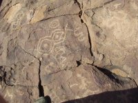
This Beausant is related to the Order that secreted the Sword and Bars .

We may think of it as their " Flag " , They Predate Pedro , as well as Columbus , for Contact with this Hemisphere .

Note the Golden Spiral of the Golden Mean is set and interconnected to denote the " Power " in all Elements of the World .

These People did not use the " Cross " after their Ostracizing by Both the Church and the State .

They no longer Hoisted the Flag of their Home Country , the Betrayal Taught them what we all need to know ,

The Support of a System is Fallacy , " We do not Stand for the System , We Stand for Humanity "

The Purpose of Secreting the Artifacts until a Time then they can be Implemented to thwart the Machinations of the System .

Current World Events , appear to me that Time is close on the Heels .

Just a perception is all .

No , the other Symbols on the Stone are not Aztec to my awareness .


, Ophir Glyphs 001.jpg
 

Feb 9, 2019
138
230
Primary Interest:
All Treasure Hunting
The Gold Mine

Note the full tummy on our Mr. Happy Glyph , the Rectangle is a Shaft/Mine

ok , The item in the Glyph we should focus on , is the weird little Plume emitting from his head .

That 3 into one image , Can be seen on the face of a Peak , at the Head of a Canyon , directly in View of this Map Rock .

The Gold Mine is up inside that Narrow Mouthed Canyon .

Note the Zig Zag line with the Arrow head at the end of it , That Zig Zag is the exact shape of the Wash you see coming down from
the Tri washes where the meet and make one wash .

Standing in the position The Photo was taken , note a line with circles go up the face of the Map Rock to the top where we find a Forth Circle at
the end of the Trail .

First Circl at Bottom of Line is " You " at this spot , next circle is on the right and is the Petro's in Massacre Canyon , third circle on Left
is the site of the Silver Mine/Smelter / Petroglyphs , 4th Circle at top and end of Trail is the Gold Mine .

see what I can do for a close up of the Mine , when I get back .

El Chato Script 077.JPG
 

Feb 9, 2019
138
230
Primary Interest:
All Treasure Hunting
The Photo is weak , I'd have to blow it up to see the Land Mark , but the Red Circle shows the Tri-Branches of the Wash above
the Gold Mine .
This shot taken from the Map Rock as I stood on the Trail lines inscribed , so you're getting the picture as seen from it's Glyph . El Chato Script 079.JPG
 

Feb 9, 2019
138
230
Primary Interest:
All Treasure Hunting
This is the Trails to the Gold Mine and other petro sites , barely visible , are the lines and circles ,
I'll fix that with my Pain Program later .

2 shots
this is beginning of trail

El Chato Script 081.JPG
 

Feb 9, 2019
138
230
Primary Interest:
All Treasure Hunting
This is end of Trail and Gold Mine Circle ( btw , look above at Happy Man , there are symbols near his glyph that you will
find near the Gold Mine )
sorry the photos a glared , I'm old , lol

El Chato Script 082.JPG
 

Feb 9, 2019
138
230
Primary Interest:
All Treasure Hunting
Ok , I re-read my post up there ,

1958 Capt. Fiegie incident , he found a side Cache ( Main Cache in reality ) on the side of VP ,

his mistake is he went to the " System " with his Find , and ,,, The " System " ripped him off and Mind Scambled him and
his Team Mates .

That discovery , and several others in that time slot, led to the U'S.'s Start Up of a Project , it would involve contact with Spain and the Offer to split
future recoveries if a Team could come to Spain and Gain Access to Maps and Documents

sorry for Typos and not being clear , Health isn't great today , rather shakey , so I'll clean up the post later . El Chato Script 045.JPG
 

Feb 9, 2019
138
230
Primary Interest:
All Treasure Hunting
Ok Steve , Oct. 4th through the 6th 1996 , for a solid 48 hours , I was walked through the sites , instructed on the meaning of the Glyphs .
shown deposit sites , held all my query's until the Didactic was completed .

Deposits that had been recovered , I was informed of the entities involved .
I was " Schooled " for the entire 48 hours , returned to my Mining Claim in New River Arizona , to continue my life .

I had but one question to posit of my instructor : " What's it all for , it's purpose I mean "

His answer , gave me understanding of the " Why " these Vaults were created and why Time concerning these was not important
nor was it relative to desired end results .
Esoteric as this sounds , The Mystery School has always been Bent to Agenda , and Time has no matter .
The Pedro Docs being at that Mission/Presidio , is not so absurd as we may first surmise , after all , it does concern Treasure deposits
and Mines , just as the unrelated Documents and Maps do .

Quote Columbus upon stepping off his Ship and onto Land : " I have no Doubt that I have Finally reached the Land of Ophir "

Interesting Comment from a Man who led his Crew to believe they were seeking a Sea Route to Asia .

Sometimes people keep secrets I guess ,,, for a Very Long Time .
 

sdcfia

Silver Member
Sep 28, 2014
3,655
8,879
Primary Interest:
Other
The Photo is weak , I'd have to blow it up to see the Land Mark, but the Red Circle shows the Tri-Branches of the Wash above the Gold Mine. This shot taken from the Map Rock as I stood on the Trail lines inscribed, so you're getting the picture as seen from it's Glyph . View attachment 1679913

Well, here's the zigzag that we believed Happy Man was indicating. All roads lead to Rome I guess.
Zigzag-2.JPG

A few questions.
1) Were you able to find an alleged carved name "Estavanico" somewhere below the petroglyphs shown in Post #41?

2) Does one of your maps have the following notation on it?
notation.jpg

3) Did you notice this pile of boulders stacked up not far downstream from "Bone Cave" (our name for it)?
boulders.JPG

018.JPG

4) [A bit OT, but have you ever seen any unusual wildlife in Sappo Canyon?]
 

sdcfia

Silver Member
Sep 28, 2014
3,655
8,879
Primary Interest:
Other
Ok Steve , Oct. 4th through the 6th 1996 , for a solid 48 hours , I was walked through the sites , instructed on the meaning of the Glyphs .
shown deposit sites , held all my query's until the Didactic was completed .

Deposits that had been recovered , I was informed of the entities involved .
I was " Schooled " for the entire 48 hours , returned to my Mining Claim in New River Arizona , to continue my life .

I had but one question to posit of my instructor : " What's it all for , it's purpose I mean "

His answer , gave me understanding of the " Why " these Vaults were created and why Time concerning these was not important
nor was it relative to desired end results .
Esoteric as this sounds , The Mystery School has always been Bent to Agenda , and Time has no matter .
The Pedro Docs being at that Mission/Presidio , is not so absurd as we may first surmise , after all , it does concern Treasure deposits
and Mines , just as the unrelated Documents and Maps do .

Quote Columbus upon stepping off his Ship and onto Land : " I have no Doubt that I have Finally reached the Land of Ophir "

Interesting Comment from a Man who led his Crew to believe they were seeking a Sea Route to Asia .

Sometimes people keep secrets I guess ,,, for a Very Long Time .

Well, we've seen lots of the same stuff and possibly interfaced with some of the same people. You certainly have more faith in the VP lore as we've been given it, but I guess we do agree that the Cookes Range is an important venue. The real value in all of this is the historical truth, whatever that may be, IMO.
 

autofull

Full Member
Mar 18, 2010
160
175
exeter pa
Detector(s) used
garrett
Primary Interest:
Cache Hunting
el chato, nice petro pics, i love them. where did you procure your documentation on all else. no proof of bars at anytime, having ever been recovered from the peak at any time exists. proof must be in the form of dated pictures or in hand and solid. not from terry carter guy. im quite open to any explanations if you will give them. a myth or story does not qualify as evidence.
 

Feb 9, 2019
138
230
Primary Interest:
All Treasure Hunting
Pedro Directs us to turn to the right upon first sight of three small peaks .
This Morning I stopped to Pic them .
Gentleman , Tres Hermanas , Pedro's small Peaks.

Chato Place 014.JPG Chato Place 014.JPG
 

Feb 9, 2019
138
230
Primary Interest:
All Treasure Hunting
Find the Spring that makes a Large Pond ( or small Lake ) Camp there where the Tules are at .

Climb the small hill in the direction the sun sets .

Pictured is the site of the Spring , the Camp he refers to , the small hill at a distance , and the Map Rock
location that is now Called Pony Hills .


Chato Place 006.JPG
 

Last edited:
Feb 9, 2019
138
230
Primary Interest:
All Treasure Hunting
From the Map Rock , there is a Small Hill ( Lomita ) at a Distance in the direction the Sun Sets , head in the direction of the Hill
and be aware of ( Marker Stones , pictures of them later ) and enter the Gap where the Sun Rises .

These various portions where Pedro uses the " Sun Rises " " Sun Sets " in his Directions is as well the cause of most researchers
confusion .

The Entire collection of his Documents , and especially his Personal Hand Drawn Land Marks and Maps , Give some solace to
the Researchers , for it narrows down the Possible Sites to perhaps just a few in Number .

Gentlemen , the Lomita , looking in the direction of the Spring and Map Rock at Site #1 Chato Place 011.JPG
 

Feb 9, 2019
138
230
Primary Interest:
All Treasure Hunting
Pedro directs us to watch for Marker Stones set in a Line as you approach site #2 and #3 .

This is " Maker Stone " #2 from the Maprock heading in the Direction of the Two Gaps on either side of the Distant Mountain .

Not the Profile looking directly at the next Rock in line , Amazing to me that this Rock was still in Position . View attachment 1680231
 

Feb 9, 2019
138
230
Primary Interest:
All Treasure Hunting
From a copy of the Translated Original Text

( He's talking about leaving the Site#3 and returning to the Map Rock and Camp at Pony Hills )

Finishing this work ( Recovery of Deposits at Site # 3 ) Return to the Spring in order to enter the Gap where the Sun Sets ( west end of a Canyon
connecting site # 2 to site # 3 is where he's directing us )

Follow these signs , they are on your right as you enter the Gap ( Marker Stones in a line from Site # 1 to the Mouth of a Canyon at Site #2 )

He then instructs to look for Several Large Boulders , each with a Color , a Yellow , Red, and Finally Blue Boulder .


The Yellow Boulder with Hand Set Boulder on smaller Rocks Chato Site 2 the Smelter and Mine.JPG
 

Feb 9, 2019
138
230
Primary Interest:
All Treasure Hunting
I will show some more ancient Glyphs , and this may be why Pedro came to these sites , searching out the Deposits
of these Eastern Mediterranean People .

Gentlemen , The Image as King Solomon and King Hiram , displayed upon their Sails for the Ships sent to Ophir .

The Image is of The Phoenician Goddess Tanit , this is just one of many of her depictions .

The Two Circles encased in her right arm , are the Two Pillars of King Solomon's Temple as seen from Above .

The Joint Venture I imagine , would require the Combining of their Sacred images .

Much is refuted , in this However , I've no need for convincing , I've held the Artifacts .

Two Cultures 009.jpg
 

Feb 9, 2019
138
230
Primary Interest:
All Treasure Hunting
This part of Site # 3 was destroyed , a much more Ancient Deposit , Note the Spiral is very well done , and Tighter then the later images
inscribed above this site .

The Cement Coating is a Mix of Cliche , Iron , and Sand Stone , the Open Face Miine for the Sand Stone is about 30 yards away from this .

Yes I know , some doubt to that , yet , close examination denotes a wider view .

Ark Ophir 016.JPG
 

Attachments

  • Ophir Glyphs 005.jpg
    Ophir Glyphs 005.jpg
    26 KB · Views: 150

Top Member Reactions

Users who are viewing this thread

Latest Discussions

Top