Curious looking site?

KANACKI

Bronze Member
Mar 1, 2015
1,445
5,927
Primary Interest:
All Treasure Hunting
Greetings all

Just for fun.

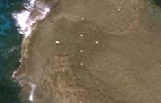
Here is goggle earth picture below of site. I will not give the name of the Atoll at present because I would like to see what people make of it with out being influenced with assumptions of its location. Is it natural or man made? the view is of some land on a coral reef magnified from Google earth from 625 feet
z1.JPG

The orientation top of picture is north bottom South , left west and right east.

the west hole Diameter is approximately 15ft and east hole Diameter about 12ft . Space between them about 125 ft
z2.JPG

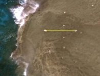
The holes from North to South is about 239 ft. Diameter of the holes about 4ft .

That atoll in question has never had a permanent population. In fact only a small part of atoll remains above sea level. There are navigation markers on the island but in another place.

It will be interesting to see what people come up with?

cheers

Kanacki
 

BillA

Bronze Member
May 12, 2005
2,186
3,218
Drake, Costa Rica
Hi Kanacki
crud, if one looks at a pic, the post disappears
are the other white spots pits also?
looking at the 2 e-w, and the 5 n-s - nothing symmetrical, apparently the 2 groups are at rt angle to one another
(not gonna make an ILS that way)
the 4 outside pits (using the sm easterly) seem at the edges of a darker area

my guess would be that someone wanted to poke around the darkened area (assay?, vol calc?)
 

Ditlihi

Banned
Aug 20, 2016
1,227
4,793
Primary Interest:
All Treasure Hunting
I've been in the desert too long, it looks like an old bombing target range superimposed over a face. :tard:
 

BillA

Bronze Member
May 12, 2005
2,186
3,218
Drake, Costa Rica
hey Dit
now I really did look at that thing, once you said it - sure

you have been in the desert too long, these really are rocks

edit: do you see the turtle ?
 

Ditlihi

Banned
Aug 20, 2016
1,227
4,793
Primary Interest:
All Treasure Hunting
Yep, I need some tequila. No worm this time. :laughing7:


Edit: No turtle, stop moving for a sec, I'm still sighting in.
 

Last edited:

Ditlihi

Banned
Aug 20, 2016
1,227
4,793
Primary Interest:
All Treasure Hunting
Look it up Wikipendeco, I have a bone in my leg.
 

Ditlihi

Banned
Aug 20, 2016
1,227
4,793
Primary Interest:
All Treasure Hunting
Tomato, tomahto. Suck it up buttercup. :tongue3:

Apologies, Kanacki, I'll remove myself to the cantina now.
 

OP
OP
KANACKI

KANACKI

Bronze Member
Mar 1, 2015
1,445
5,927
Primary Interest:
All Treasure Hunting
Hello Bill and Ditlihi

interesting?

I have no idea what it is? Seeing what appears to be a line of holes gives me the impression it was man made. But some time nature can do strange things.

Kanacki
 

BillA

Bronze Member
May 12, 2005
2,186
3,218
Drake, Costa Rica
Kanacki
the arial is nice, but the resolution sux
were the connecting lines more symmetrical 'twould be better

be careful, you'll be looking at rocks with Dit for indications of . . . . . (natural weathering)

edit: did you get the hole depths from that photo ?
if so, how ?
thanks
 

OP
OP
KANACKI

KANACKI

Bronze Member
Mar 1, 2015
1,445
5,927
Primary Interest:
All Treasure Hunting
Hello BillA

It was through google earth through magnification it gives on the side how many feet from the ground its magnified up to. From that height I measured the approximate diameter of holes only. I have no way of knowing any depth to the holes. I know from using google earth from experience you can see illusionary marks from high above not viable on ground level. Yes the resolution is poor.

Kanacki
 

mdog

Bronze Member
Mar 22, 2011
2,325
4,377
I think Dit is close. Looks like artillery practice from a naval vessel.
 

nagant

Hero Member
Apr 21, 2017
765
932
iowa
Detector(s) used
Tesoro Golden micromax, compadre. ML EQ 800
Primary Interest:
All Treasure Hunting
Mount Suribachi?
 

Samanthy

Full Member
Apr 22, 2018
219
251
Phoenix, Arizona
Detector(s) used
White‘s Sierra Madre
White‘s TM–600
Primary Interest:
Cache Hunting
The only way to know is to check it out. Nothing ventured, nothing gained.
 

OP
OP
KANACKI

KANACKI

Bronze Member
Mar 1, 2015
1,445
5,927
Primary Interest:
All Treasure Hunting
Hello Samanthy

True but for me it is long ocean transit either through Panama carnal or round cape Horn.
 

Mackaydon

Gold Member
Oct 26, 2004
24,077
22,849
N. San Diego Pic of my 2 best 'finds'; son & g/son
🏆 Honorable Mentions:
2
Detector(s) used
Minelab Explorer
Primary Interest:
Shipwrecks
My friend, Kanacki,
Once I know the location, I will have a better chance of guessing.
Question: What were you researching to come up with this pic? (If you don't mind me asking.)
Another Q: Is that a 'tiki' under your name? I found one on Mo'orea.
Don...
 

OP
OP
KANACKI

KANACKI

Bronze Member
Mar 1, 2015
1,445
5,927
Primary Interest:
All Treasure Hunting
Hello Makaydon

The Rocas Atoll is the only atoll in the South Atlantic Ocean. It belongs to the Brazilian State of Rio Grande do Norte. It is located approximately northeast of Natal and west of the Fernando de Noronha archipelago. The atoll is of volcanic origin and coralline formation.

I have no particular interest in the atoll. It was just curious site while searching google earth research movements of Brazilan pirates and slavers from 1828-1849.

The image on my Avatar is not a Tiki although it sort of looks like one. Its actually Celtic Pict deity. Brigantia British goddess connected with river and water cults, equated with Minerva, by the Romans and possibly linked with the goddess Brigit. It is believed to be 4th century and the oldest known representations of her. It was found in a stone circle in the hills where my great grand father lived as crofters.


Kanacki
 

Last edited:

Top Member Reactions

Users who are viewing this thread

Top