🔎 UNIDENTIFIED A cannon ball (maybe)

Oct 1, 2018
422
647
Western PA, Northern NJ
Detector(s) used
Garrett AT Max
Primary Interest:
All Treasure Hunting
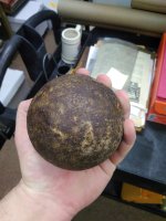
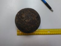
I was at a museum in Mahwah, NJ and came across this item. They didn't know exactly what it was or where it had come from, only that it was found in a drawer in the museum while some things were being cleaned out. They think it's a cannon ball, but don't know anything else. It's approximately 7 lbs and 4" in diameter. I'm no expert, but I know a few people around here are.
 

Attachments

  • IMG_20211120_104917.jpg
    IMG_20211120_104917.jpg
    1 MB · Views: 194
  • IMG_20211120_105001.jpg
    IMG_20211120_105001.jpg
    631.5 KB · Views: 81

CreakyDigger

Gold Member
Jul 23, 2019
7,150
23,454
Upstate NY
Detector(s) used
White's Spectra v3; Equinox 600
Primary Interest:
All Treasure Hunting
It certainly looks like one, but I've never heard of a 7-pounder from the era of round balls.
 

Upvote 1

TheCannonballGuy

Gold Member
Feb 24, 2006
6,542
13,069
Occupied CSA (Richmond VA)
Detector(s) used
White's 6000, Nautilus DMC-1, Minelab
Primary Interest:
Relic Hunting
In other words... the data chart posted by Creskol does not tell the diameter of any actual cannonball -- it merely tells the diameter of a solid (not hollow) cast-iron ball which weighs exactly 2.0 pounds, 3.0 pounds, 4.0 pounds, etc.

That chart appears in the US (Army) Ordnance Manual of 1861. We cannonball collectors use it to determine with certainty whether a solid ball is made of cast-iron, or steel, or some other metal.

For example, the 1861 Ordnance Manual's "Shot Tables" says a 12-Pounder caliber (4.62" bore-diameter) cannon's cast-iron Solid-Shot cannonball was precisely 4.52-inches in diamter, and weighed precisely 12.25 pounds (12 pounds 4 ounces). So, for example, somebody on Ebay is selling a "civil war cannon ball" which measures exactly 4.52-inches in diameter. So far, so good. However, the seller also says his 4.52" cannonball weighs 13 pounds 2 ounces. Thus, according to the Ordnance Manual chart Creskol posted, the seller's 4.52", 13-pound ball is definitely NOT a cannonball... because it weighs more than a 4.52-inch cast-iron ball weighs. The only way that is possible is, the ball is made of Steel, which is about 10% heavier than cast-iron. There were no steel cannonballs used in the US civil war. The Ordnance Manual says all cannonballs were made of cast-iron or lead. If a ball is made of Steel, it is not a cannonball.

www.civilwarartillery.com/shottables.htm
 

Last edited:
Upvote 17

gunsil

Silver Member
Dec 27, 2012
3,863
6,204
lower hudson valley, N.Y.
Detector(s) used
safari, ATPro, infinium, old Garrett BFO, Excal, Nox 800
Primary Interest:
All Treasure Hunting
Hey Envoy, I go to Mahwah fairly often, did not know there was a museum there. Mahwah is right close to the site of the old Fort Ramapo which is mostly under the thruway/I 287/Rte 17 interchange so entirely possible for a cannonball to have been found in the area before they built the big roads. I go for great Mexican food in Suffern and Mahwah for gasoline which is cheaper in NJ than NY.
 

Upvote 3
OP
OP
EnvoyToTheMolePeople
Oct 1, 2018
422
647
Western PA, Northern NJ
Detector(s) used
Garrett AT Max
Primary Interest:
All Treasure Hunting
Hey Envoy, I go to Mahwah fairly often, did not know there was a museum there. Mahwah is right close to the site of the old Fort Ramapo which is mostly under the thruway/I 287/Rte 17 interchange so entirely possible for a cannonball to have been found in the area before they built the big roads. I go for great Mexican food in Suffern and Mahwah for gasoline which is cheaper in NJ than NY.
I didn't know about Fort Ramapo, it would make sense if a few cannon balls could be found there. The museum is just called the Mahwah Museum, if you'd like to visit. They have a lot of information on the local Indians, among other things. One of their big attractions is an exhibit on Les Paul guitars, but I don't know much about that.
 

  • Like
Reactions: Fat
Upvote 1
OP
OP
EnvoyToTheMolePeople
Oct 1, 2018
422
647
Western PA, Northern NJ
Detector(s) used
Garrett AT Max
Primary Interest:
All Treasure Hunting
Hey Envoy, I go to Mahwah fairly often, did not know there was a museum there. Mahwah is right close to the site of the old Fort Ramapo which is mostly under the thruway/I 287/Rte 17 interchange so entirely possible for a cannonball to have been found in the area before they built the big roads. I go for great Mexican food in Suffern and Mahwah for gasoline which is cheaper in NJ than NY.
I just looked up Fort Ramapo and couldn't find anything about it. Where could I find more information?
 

Upvote 0

gunsil

Silver Member
Dec 27, 2012
3,863
6,204
lower hudson valley, N.Y.
Detector(s) used
safari, ATPro, infinium, old Garrett BFO, Excal, Nox 800
Primary Interest:
All Treasure Hunting
There used to be a historical marker on 17 near the thruway exit stating it was the site of Fort Ramapo, the sign is no longer there. The sign was not actually on the site and I have no idea why it was removed. The Rockland County Historical Society knows about it. I have spent many hours in the last fifty years trying to find some part of it that isn't under the pavement to no avail. Remains of a small part of a trench were excavated by archies who did find rev war buttons there. I assure you, most all of the rev war site is under the highways, progress usually causes the ruin of many historical sites. The rev war supply depot in Fishkill, NY is mostly under the pavement of the old Dutchess County Mall, built in the 1970s with no consideration of the history of the area. Fort Ramapo guarded the Ramapo Pass to prevent the Brits from coming up from Jersey and making an attack from the rear on West Point. Ft Ramapo was also a quarantine place for soldiers with smallpox and at one point there were 500 soldiers either quarantined or stationed there so it must have covered a fairly large area. If you are close to Mahwah, send me a PM, maybe we can meet and I'll show you the area. I am down near Nyack and it is maybe 12-15 miles from me. I think the fort is mentioned in "Greene's History of Rockland County" and also in "Now and Then and Long Ago", another history of Rockland County. Research is paramount, they are great books for local history.
 

Last edited:
Upvote 1
OP
OP
EnvoyToTheMolePeople
Oct 1, 2018
422
647
Western PA, Northern NJ
Detector(s) used
Garrett AT Max
Primary Interest:
All Treasure Hunting
There used to be a historical marker on 17 near the thruway exit stating it was the site of Fort Ramapo, the sign is no longer there. The sign was not actually on the site and I have no idea why it was removed. The Rockland County Historical Society knows about it. I have spent many hours in the last fifty years trying to find some part of it that isn't under the pavement to no avail. Remains of a small part of a trench were excavated by archies who did find rev war buttons there. I assure you, most all of the rev war site is under the highways, progress usually causes the ruin of many historical sites. The rev war supply depot in Fishkill, NY is mostly under the pavement of the old Dutchess County Mall, built in the 1970s with no consideration of the history of the area. Fort Ramapo guarded the Ramapo Pass to prevent the Brits from coming up from Jersey and making an attack from the rear on West Point. Ft Ramapo was also a quarantine place for soldiers with smallpox and at one point there were 500 soldiers either quarantined or stationed there so it must have covered a fairly large area. If you are close to Mahwah, send me a PM, maybe we can meet and I'll show you the area. I am down near Nyack and it is maybe 12-15 miles from me. I think the fort is mentioned in "Greene's History of Rockland County" and also in "Now and Then and Long Ago", another history of Rockland County. Research is paramount, they are great books for local history.
Interesting. It's strange that I can't find anything online. The only mention of Fort Ramapo on google is a road in Suffern, NY called Fort Ramapo Ave, but it looks like this road has been renamed to Ramapo Ave. I'll have to look into those books. I'm at college right now, but I'll be back in two weeks. I'll let you know when I can visit the fort site.
 

Last edited:
Upvote 0

TheCannonballGuy

Gold Member
Feb 24, 2006
6,542
13,069
Occupied CSA (Richmond VA)
Detector(s) used
White's 6000, Nautilus DMC-1, Minelab
Primary Interest:
Relic Hunting
42 Scout car said:
> Did i miss it? Did it come back as a cannonball ?

No, it is definitely not a cannonball.
Again, let's go to the Shot Tables and look for the section titled "Descriptions of Solid Shot [and shells] for Smoothbore Guns."
The Original Poster says its diameter is 4 inches and it weighs ("approximately") 7 pounds. There's no ball which is that size or weight in the US Ordnance Manual's cannonball Shot Tables. The closest match is a 9-Pounder caliber ball, which was 4.1" in diameter -- but weighed 9.14 pounds, not 7 pounds.

Of course in this case there's a possibility that serious errors were made in weighing and measuring the museum's ball. (He said "approximately.") For PRECISE measuring, a Postal Shipping scale is needed (which weighs things in pounds & ounces, not just pounds)... and a large Caliper for accurately measuring the ball's diameter. If a return trip to the museum with those two precise-measuring devices produces a different result than 4.0 inches and 7.0 pounds, let me know.

Meanwhile, for further info:
I co-wrote a detailed educational article about how to accurately measure a metal ball and correctly determine its actual identification (an Artillery-ball or Civilian-usage ball).
The article contains several helpful photos and diagrams.
Its title is:

Solid Shot Essentials: A Guide to the Authentic and Non-Authentic​


Last edited:
Upvote 6

dieselfool

Full Member
Dec 27, 2012
209
295
Primary Interest:
All Treasure Hunting
We used to have an old truck scale from the 1920s on our farm. When it was torn out the steel bearings were very similar to that.
 

Upvote 2

TORRERO

30+ YEARS, XP DEUS I & II ARE MY GO TO MACHINES
Nov 17, 2004
1,665
1,063
NC
Detector(s) used
XP DEUS I & II
Primary Interest:
All Treasure Hunting
This sounds like what he describes..

"Fort Ramapough Site"

Corridor Through the Mountains​

Smith's Clove: Wartime Line of Communication and Passageway for the Continental Army, 1776-1783​

Richard J. Koke​

[Editor's Note: Richard J. Koke authored a series of five articles that appeared in Volumes 19 -23 of the OCHS Journal between 1990 and 1994. These articles will be presented in multiple sections over the next few years.]
Part VI:
The Blockhouse Door - And Afterward
Chapter 2:
The Post at Sidman's Bridge
Sidman's bridge, where Route 59 - the old Clove Road - crosses the Ramapo River and where the military post of 1776-1783 was situated within the lower entrance to Smith's Clove, is now a forgotten name. Vestiges of the earthwork laid out by Lieutenant Thomas Machin in 1776 across the narrow gorge below the bridge to block an enemy advance from the south remained into the 20th century. The only contemporary description of this barrier between the mountain and the river, through which the Clove Road passed, was that of Colonel Jedediah Huntington in November 1776 who described it as "a musketry line."


LOWER ENTRANCE TO SMITH'S CLOVE sometimes called Sidman's Clove and later the Ramapo Pass. 1. Site of John Suffern's tavern, northwest corner of Washington and Lafayette avenues, Suffern. 2. Sidman's Bridge across the Ramapo River. 3. Line of American entrenchment, constructed November 1776 between the mountain and Ramapo River, as indicated on R. E. O'Connor map of Rockland County, 1854. 4. Tablet, 1922, Torne Valley Road, marking Ramapo entrenchment. 5. Former Ramapo Presbyterian Church and graveyard, junction of Routes 17 and 59. Approximate site of "Little redoubt" of 1776, the "old fort" depicted on Erskine maps and the blockhouse of 1781-83. The Revolutionary War barracks for the Sidman garrison were probably also in this area. 6. Site of Shuart's house, Route 59, American Revolution. 7. Fox Hollow Tablet, 1904, Route 17, Hillburn, commemorating the post at Ramapo. 8. Ramapo Works, important 19th-century industrial village, now vanished, established 1795 by Josiah and Jeremiah Pierson on land purchased from John Suffern.
The site was thereafter well remembered. In 1850 Benson Lossing wrote that the embankment, overgrown with trees, was "quite prominent" and "with care these mementoes of the past may be long preserved." A year later the remains were pointed out as an attraction for passengers in Harper's New York and Erie Railroad Guide Book, with which Lossing was associated as an illustrator. Marked as an "Intrenchment," the barrier is indicated as a dotted line across the pass on R. E. O'Connor's Map of Rockland County in 1854, and in 1859 the site was marked as "Quarantine in 1778. Gen.l Morgan's Intrenchment" on Corey and Bachman's Map of Orange and Rockland Cos. According to Colonel William Winthrop of the United States Army, who visited the locality in the 1880s, the remains consisted of a well defined embankment about 150 feet long and about ten broad stretching across a field near the river and as late as 1927 the ground was marked as "Fort Ramapough Site" on a topographical map of the Bear Mountain-Harriman Section of the Palisades Interstate Park. When visited by the present writer in 1952, the last trace of the entrenchment close to the mountain had recently been graded and obliterated.
The "little redoubt" of 1776, the "Old Fort" shown on the Erskine maps and the blockhouse of 1781-83 were all north of the bridge in the vicinity of the present junction of Routes 17 and 59. The precise locations of the barracks of 1776-80 are not known, but they undoubtedly stood on the level ground north of the bridge between Route 17 and the Ramapo River, later tilled by the Pierson family and utilized as a right-of-way for the Erie Railroad.
The "Quarantine in 1778" cited on the Corey and Bachman map evidently had some basis in prevailing local folklore. According to the chronicles of the Belcher family of Sloatsburg, Eleanor L. Belcher related to her sons in the middle 1800s "that a South [sic] Carolina regiment was encamped near Ramapo Pass and that many of them died from smallpox," and prior to the Civil War "a score of graves marked by flat stones with no inscriptions" could be seen below Sloatsburg "on the road to Ramapo," which were also seen by William H. Belcher. William, in turn, affirmed his belief "that these were undoubtedly the last resting places of the men who were carried off by smallpox in the Revolution, as related by his mother. The road which passes that locality," he said, "is now abandoned and a new road made, and no one seems to know anything about these neglected memorials of the brave men whose lives were sacrificed there for their country."
The location of these graves is not known, but what is interesting is the enduring remembrance over a period of more than half a century of a Carolina presence in the corridor, despite the brevity of their stay for only a few weeks at the close of 1778 when the North Carolina brigade - not South Carolina - was posted in the Clove to prevent deserters from Burgoyne's captive army from making their way through the corridor to New York.
The quarantine story persisted for generations and even as late as 1909, according to Theophilus N. Glover, writing for the Bergen County Historical Society, the area below Sidman's bridge was still called the "Quarantine Ground," and with it a tradition "of the complete annihilation of a Carolina regiment...by camp fever" and that the graves were "plainly visible twenty-five years ago." Contrary to this recurring tale, however, contemporary wartime sources make no mention whatsoever of a quarantine camp, nor deaths by smallpox, nor is there any known connection with the entrenchment with Daniel Morgan, who in November 1778 was a colonel and not a general when on temporary duty at Pompton.
The construction of the New York Thruway and realignment of the Ramapo River along the base of Little Mountain in the 1950s and the major highway alterations of the 1990s for the linkage of the Thruway with Interstate 287 took their toll of the ground on both sides of the river where the military post had been located. The convergence of highways into the corridor, in another sense, could only serve, however, to reemphasize the importance given this great pass in the defense strategy of the Hudson Highland command during the Revolutionary War.
When Colonel William Winthrop journeyed to the Ramapos in the 1880s to search out the remains of the Sidman fortifications, his attention was also directed to another entrenchment in Fox Hollow on the upland ridge west of the Ramapo behind Little Mountain at Hillburn, about a mile below the junction of Routes 17 and 59.
This earthwork, stretching across the narrow defile overlooking the valley, may well have been intended as a protective cover to secure the Sidman position at the bridge against a flank attack from the Jersey side by way of the tangled Hillburn country and through the hollow that could open the way for a hostile descent onto the flank and rear of the Sidman post from the high ground to the southwest.
The possibility of such a move was more than inherent in November 1776 when the Jersey tories were openly boasting that they would guide the British to the Clove to surround and cut off the hard-pressed Continental garrison under Colonels Huntington and Tyler. Winthrop described the Fox Hollow remains as a grassy mound about 100 feet long, fifteen to twenty broad and from four to five feet high. Today it is woodland.
 

Upvote 2

gunsil

Silver Member
Dec 27, 2012
3,863
6,204
lower hudson valley, N.Y.
Detector(s) used
safari, ATPro, infinium, old Garrett BFO, Excal, Nox 800
Primary Interest:
All Treasure Hunting
Torerro, thread is 2&1/2 years old. Envoy to the mole people and I met up and I took him to the site back in early 2022. There is nothing at all left of the old fort, it is totally under the NYS Thruway and the Rte 17 interchange. Envoy no longer lives in the area. Sidman's Inn still stands and has recently been somewhat restored but they built a big condominium complex around it in the last couple of years.
 

Upvote 2

TORRERO

30+ YEARS, XP DEUS I & II ARE MY GO TO MACHINES
Nov 17, 2004
1,665
1,063
NC
Detector(s) used
XP DEUS I & II
Primary Interest:
All Treasure Hunting
This seems to happen a lot on here, where it appears to be a legitimate thread only to be told its two years old..
:dontknow: :dontknow: :dontknow:
 

Upvote 1
OP
OP
EnvoyToTheMolePeople
Oct 1, 2018
422
647
Western PA, Northern NJ
Detector(s) used
Garrett AT Max
Primary Interest:
All Treasure Hunting
I went away on vacation and came back to find an act of necromancy on one of my posts. This was a fun adventure, though, so I'll gladly elaborate. After my post, Gunsil got in contact and showed me around the former fort site. Like he said, it's largely been developed, but any enterprising person could go search in the woods to the east of the railroad tracks and maybe come up with something. I was searching around here (41.134550, -74.165950) and found a colonial button and spoon. I asked about the spoon hallmarks and was told it is probably an early 1800s fake (https://www.treasurenet.com/threads/spoon-hallmarks.665005/#post-6863752). I tried to get in touch with the museum curator and tell her what I found out about the cannonball, but she never responded to my email. I think I returned to the site twice after Gunsil showed me around, but then I got a horrible case of poison ivy there and never went back. Thanks for taking an interest everybody.
 

Upvote 3

Top Member Reactions

Users who are viewing this thread

Top