morbiusandneo
Sr. Member
- Jun 16, 2007
- 392
- 50
- Detector(s) used
- Dowsing rods
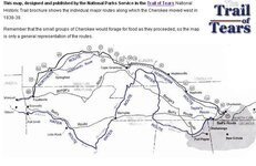
Cherokkee march the "Trail of Tears"
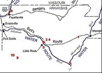
I can't find even half of my research papers, etc.....From about 1980-1989 I was an armchair TH. Did a lot of research and bought many books and mags, etc....I have two questions. In the 1830's the Cherokkeee were all rounded up in north Georgia to be forced marched to a new reservation in Oklahoma. The reason was GOLD. Whites wanted it, yet the red man HAD it! I believe there are still many, many lost mines around Dahlanega, GA that they hid before they were evacuated. Many, many caches, too, I'm sure. That is the first question. Does anyone have some definitive research lead/information other than Penfield or Terry about any caches by the Cherokkee before the forced march? Second question is about when they were held up at the Mississippi River the whole winter in S.Illinois. I remember reading somewhere, and copied the article, about this location description. There was a reference to "...some power lines off a certain interstate near mile marker such-and-such...". Does anyone know exactly where this encampment was with a very good description? They just mustuv hidden stuff they could no longer carry that I could pinpoint with a MD....Thanks in advance, steven.
I can't find even half of my research papers, etc.....From about 1980-1989 I was an armchair TH. Did a lot of research and bought many books and mags, etc....I have two questions. In the 1830's the Cherokkeee were all rounded up in north Georgia to be forced marched to a new reservation in Oklahoma. The reason was GOLD. Whites wanted it, yet the red man HAD it! I believe there are still many, many lost mines around Dahlanega, GA that they hid before they were evacuated. Many, many caches, too, I'm sure. That is the first question. Does anyone have some definitive research lead/information other than Penfield or Terry about any caches by the Cherokkee before the forced march? Second question is about when they were held up at the Mississippi River the whole winter in S.Illinois. I remember reading somewhere, and copied the article, about this location description. There was a reference to "...some power lines off a certain interstate near mile marker such-and-such...". Does anyone know exactly where this encampment was with a very good description? They just mustuv hidden stuff they could no longer carry that I could pinpoint with a MD....Thanks
in advance, steven.


 ?Thanks in advance.... stvn.