Clay Worst search area

Cubfan64

Silver Member
Feb 13, 2006
2,986
2,789
New Hampshire - USA
Detector(s) used
Fisher CZ21, Teknetics T2 & Minelab Sovereign GT
Primary Interest:
All Treasure Hunting
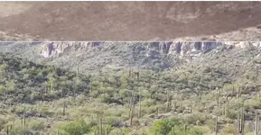
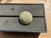
Paul, that image is definitely reversed. The cliff background is, well, backwards ;)

I thought that too, however that's assuming the board house was where I think it was, but I wonder if you went to the ridge Wayne went to and looked to the NW (towards where Hedrick said the board house was) if the dacite cliffs would be in the background like Tom's photo shows?
 

PotBelly Jim

Hero Member
Dec 8, 2017
898
2,985
Primary Interest:
Other
I thought that too, however that's assuming the board house was where I think it was, but I wonder if you went to the ridge Wayne went to and looked to the NW (towards where Hedrick said the board house was) if the dacite cliffs would be in the background like Tom's photo shows?

Where were you standing when you took your pic?

EDIT:

Here's part of Tom's pic, flipped to the right orientation, right on top of the same area of your pic:

attachment.php


IMO you were standing to the NE of whoever took Tom's pic, but in the same general location.
 

Attachments

  • Cliffs.jpg
    Cliffs.jpg
    32 KB · Views: 409
Last edited:

Cubfan64

Silver Member
Feb 13, 2006
2,986
2,789
New Hampshire - USA
Detector(s) used
Fisher CZ21, Teknetics T2 & Minelab Sovereign GT
Primary Interest:
All Treasure Hunting
Where were you standing when you took your pic?

EDIT:

Here's part of Tom's pic, flipped to the right orientation, right on top of the same area of your pic:

attachment.php


IMO you were standing to the NE of whoever took Tom's pic, but in the same general location.

I don't have the exact location of where we were, but the red circle is a pretty good estimate although it may have been higher up

attachment.php
 

Attachments

  • paul ge qcu 2.JPG
    paul ge qcu 2.JPG
    158.1 KB · Views: 401

Cubfan64

Silver Member
Feb 13, 2006
2,986
2,789
New Hampshire - USA
Detector(s) used
Fisher CZ21, Teknetics T2 & Minelab Sovereign GT
Primary Interest:
All Treasure Hunting
Where were you standing when you took your pic?

EDIT:

Here's part of Tom's pic, flipped to the right orientation, right on top of the same area of your pic:

attachment.php


IMO you were standing to the NE of whoever took Tom's pic, but in the same general location.

Yeah - looking at it that way I do agree.
 

PotBelly Jim

Hero Member
Dec 8, 2017
898
2,985
Primary Interest:
Other
That's about where it looked like to me. Just wanted to make sure. Looks like Tom K is sitting down there at a picnic table with some other people in your pic ;) Just under the water tank.

This has been a good discussion, but I think I should get to bed! Thanks guys!
 

markmar

Silver Member
Oct 17, 2012
4,117
6,259
Primary Interest:
All Treasure Hunting
IMO, this is the Clay Worst search area and more, during his 70 years of research in the western Superstitions. He is a live example how never is too late to find out where probably is the end of the rainbow.

attachment.php
 

Attachments

  • West Superstitions.jpg
    West Superstitions.jpg
    166.2 KB · Views: 325
Last edited:

Ramiro valdez

Full Member
Aug 26, 2020
182
103
San Antonio, Texas
Primary Interest:
All Treasure Hunting
Well, our focus here is in exposing the location of the LDM. I quickly buzzed through a lot of history in a short time in order to generate a good story that makes sense to me. This is a good story for those who no nothing about the LDM. Those who know too much probably get caught up in the grammar, specific year, the written, unwritten, and loose focus of the main goal. Some people creat story that just don’t make sense and that’s why I try to stay within certain perimeters of what would make sense. The truth is that a lot is unwritten and you have to make sense in order to find truth about what is unwritten. In this case I’m not concerned with who finds the LDM, the concern is to locate the LDM so someone can find it. So because someone brought up the old board house in a sense I will put it in perspective and talk about it.


The board house is a historical place, the last stop before going in to the dangerous superstitious mountains. It was a starting place for many who went out into the superstitious mountains looking for the mysterious gold mine. It’s actually a good idea when you don’t know exactly where your headed. The idea is to get to the highest peak nearby so you can evaluate the surrounding mountain ridges to the one that might lead you to the gold mine. But before we get any further we should step back in time to evaluate the beginning of this mystery gold mine. The story probably dates back to the time of the Aztecs. I often wonder why the Aztecs decided to name a monumental peak, Aztec peak? Now that’s a thought, you might want to investigate? But, let’s talk about the 1500’s when the conquistadors were roaming the land looking for gold. Besides being mislead by native Indians they did manage to build a few forts, one in particular was never recorded. It was located on top of the Sierra Ancha mountain range. The Indians destroyed the fort but they left the imprints of building location and the roads that lead to three outpost that protected the fort. The Spaniards abandon their campaign in search of the cities of gold which were just lies created by native Indians. They could no longer trust the natives and decided to regroup in figuring out a better plan which took many years to develop. Through the 1700’s they came back slowly trying to settle the south edging towards the north with the help of the Jesuits whom were helping to convert the southern Indians. The Jesuit were becoming a problem for the loyalists Spaniards whom were treating Indian unfairly. The natives revolted in 1750 after being treated unfairly and underpaid. The pope cited on the side of the Spanish crown and order the recall of the Jesuit’s from New Spain. The Jesuits never left and continued their cause in helping the native Indians. The Jesuits were not liked by the loyalists Spaniards, Pope, other religious orders or northern Apache. After Mexico gained independence the order was reinstated by the pope, but it did not stop the enemies from pushing forward in doing away with the order. Their time was ticking and the only thing left was to ask for help from their American Jesuits counterparts whom created a plan to help them in their time of need. The plan was to send in a team of trusted soldiers whom would locate a mystery mine that would produce enough gold to help gather an army that would fight for a good cause. Beale and company located the mystery mine with the help of the Indians. The order was working in secrecy under Beale and their first order was to pay themselves enough for the service they we’re about to do. The second phase was to mine more gold for the cause which never developed because the northern Apache was not in agreement with their planning. The Apache had other plans to fight against the invading Spaniards and the invading Americans. Beale understood the dangers of the mission and creat several cipher stones to leave behind that no one would understand except the order in order to continue with the Christian cause if they were to fail the mission. The Apache did away with their plan causing the final blow and the fall of the Jesuits in Mexico. them and the Jesuit order was forced to dissolve. The Apache succeeded in hiding the gold mine once again from every one looking for it. In the mid 1840’s the Peralta family discovered the whereabouts of the secret mine which was guarded by the Apache. They found ways to extract gold without getting caught in small sums. The family was pressured by word that the Americans would soon take control of the land and did the unthinkable. They went with numbers into the mine and extracted a great amount of gold which took sometime alarming the two Apache tribes to come together in forming a trap were they would slaughter them for their transgression. The Apache once again gain control of the mine. Years later a man named Joseph Waltz discovered the whereabouts by the help of a Peralta family member whom gave waltz direction to include a personal map of the area of location. Waltz gave away many clues and his personal map, but never gave exact direction of location. The reason one needs to know more history of the story is to gain understanding of actions that were taken which in the long run will make sense because at the end of the find you are probably going to say wow! That makes sense, why did I think about it. It happens hundreds of times so it’s good to always try to make sense of what your looking at or reading. This is what makes sense to me and this is the sense that your going to need in deciphering the stones which is the next thing to do starting with the stone that describes a Jesuit priest.
 

Ramiro valdez

Full Member
Aug 26, 2020
182
103
San Antonio, Texas
Primary Interest:
All Treasure Hunting
The Stone


The stone that carries the Jesuit priest is the most important stone. This stone describes the initial start of the story that took place. Half of the information on it belongs to Arizona and the other half to Virginia.The Jesuits started unfolding their secret plan when Beale reached Santa Fe, in 1819. The converted or southern Indian natives aligned themselves with the Jesuits which were helping them to fight against slavery. The Indian natives led Beale to the secret gold mine in secrecy. The Indian natives were not all in accordance with the plan and were probably having discussion over the on going mission. Beale did finish the first part of the mission which was to secure their payment for their service. On his return to complete the second phase of the mission he and his associates were killed by the Apache who were against the Mexican and American government to also include the Jesuits. This specific stone you see below explains the beginning of what took place during the first phase. This story will play out and all you have to do is follow the the path to get to what your looking for.

415C4A12-11B8-476D-B499-D3A43AEB3681.jpeg
 

Ramiro valdez

Full Member
Aug 26, 2020
182
103
San Antonio, Texas
Primary Interest:
All Treasure Hunting
In order for the stones to survive the creator of the stone had to be creative in hiding the message that would help and lead the next group to the location of the mine by inscribing clues on the stone so they could accomplish the second part of the secret mission. This makes sense and therefore he decides to inscribe two monumental rock structures located near the mine so they can find the entrance to the hidden canyon that leads to the mine. One rock structure is curved and looks like an eyebrow and the other is a circular rock structure. He position the structure’s facing in a northerly direction according to the Jesuits directional cross. The actual layout of these structures will change in direction to their proper directional position when you find the location. As you see in the photo below make sure you pay attention to the structures and the pointed mountain edge on the left because later it’s going to be used as a pointer.

D0F1A399-6283-471D-A5E6-B07D068E9E6C.jpg
 

Ramiro valdez

Full Member
Aug 26, 2020
182
103
San Antonio, Texas
Primary Interest:
All Treasure Hunting
That makes sense in order to not draw attention. So, the story goes like this , the Jesuit priest is given authority by the natives Indians to bless the gold that is about to be taken for their cause. The Jesuit is standing on a monumental rock structure with a pointed hat or sombrero that can only be described as the needle. The base of the structure reads 1847 describing a base altitude. This number can only mean two things when one is trying to locate the base of a mountain. This number can only be referred as feet or meters from sea level location. Feet’s will never work because it’s not even close to the needle’s altitude. But meters, that a different story? In meters the needle is the one that don’t come close because it’s too short. We can call the needle stubby because it’s too short, but since we’re not really looking for stubby then that draws the question of who’s base are we talking about? The priest directional cross has just given us the direction of where the mine lays. The cross points toward the north indicating that the mine sits between the north and the East towards the eastern mountains. The Sierra Ancha mountains sit slightly above 1847 meters from sea level and Aztec peak even higher. The base number 1847 that the creator is talking about pertains to the base of the hidden gold mine. From the top of the needle, who also is able to points the same direction, across the salt river valley to the top of the Sierra Ancha mountains northeast at 1847 meters from sea level you will find an area call the rock horse canyon. So if you are standing on top of the needle don’t look down because the only thing you will find is stolen gold, silver mines, and other old goldmines that will not come close to what your looking for. The initial gold will be taken from the gold mine for payment which will be taken to be buried in the east. The small cross intel's the northerly direction that you will take in approaching the canyon above 1847 meters above sea level. If you use the old Indian trail you will come upon a pointed rock edge from where you will view the entrance to the canyon. At this point you must position yourself properly by the use of the small cross which will point to the location of the mine inside the hidden canyon. The gold will be taken towards the south as indicated by the small cross then to the east working its way towards the northeast. The gold is to be buried along the way in three different monumental structure locations. One of the rock structure is slightly curved like the one found near the mine which faces south. The second one is a circular rock structure, similar to the one near the gold mine, which is followed by a third structure in shape of a heart situated to the north of the circular rock structure. At this point I must add that a lot of the historical information, gathered to creat this story, comes from many other treasure hunters. What I know also help to piece together this story that will lead someone to locate the mystery mine. With that in mind the next clue was identified by another treasure hunter to be a bar code ( 8-N-P ) from Virginia which happens to be the bridge that is going to take us into Virginia. The stone maker gives caution of 18 dangerous places along the way that one should be careful when removing the gold from the three sites. He directs you to use the current map of Virginia in order to find the heart monumental structure, first. At the end, he described by a symbol, that you must go over the mountain to get to the heart. The next stone to describe is the one with the Santa Fe horse before going into the center stones that will guide you to the heart located in Virginia. At the end of this story there is going to be two more clues that will identify the gold mine again in Arizona, feel free not wait for the ending because you will only be waist time if you want to get there first.
 

dredgernaut

Hero Member
Dec 27, 2012
560
1,444
wisconsin
Detector(s) used
whites mxt, tesoro lobo super trac., monster1000
Primary Interest:
All Treasure Hunting
wow... now, that is a twist... ummm.. virginia huh.. why not..:icon_scratch:
 

Ramiro valdez

Full Member
Aug 26, 2020
182
103
San Antonio, Texas
Primary Interest:
All Treasure Hunting
Thanks, guys! I’m glad someone is making use of this particular story! I think the Gentleman needs to make a change towards the east way out east. It’s never too late to make a change, Cruise-Wilkins in Indian Ocean is allot worse, so right he takes the cup and I hope that one day he will listen to me. It’s the weekend which means family time, so I have to stop writing until Monday see you guys then. Thanks, again.
 

dredgernaut

Hero Member
Dec 27, 2012
560
1,444
wisconsin
Detector(s) used
whites mxt, tesoro lobo super trac., monster1000
Primary Interest:
All Treasure Hunting
ramiro.. i was actually being sarcastic... sorry. i am a jerk. lol.. i do not see any correlation between the stones and virginia... i think, IF they are authentic.. then they most likely apply to the general area of their discovery.. but i can appreciate your theory.. just seems to be really reaching.. not to mention all the legends of rich mines, spanish and native caches in and around the superstitions.. why would a map found in the area of such fabled wealth lead you 1000 miles east.. just sayin... sorry, just my opinion..
 

Ramiro valdez

Full Member
Aug 26, 2020
182
103
San Antonio, Texas
Primary Interest:
All Treasure Hunting
I always encourage people to read as much history as possible if your going to define that which has not been clearly defined in order to find leads that will lead you in finding the lost history that will define the item in question. Everything has a history in its own time, we just have to find it. The best way is to find all the roads and stories that lead to the same place. The stones in question carry a story with hidden cipher location messaging that will help you locate the evidence that you need if you know how to read them. The one common thing that we know, to all, is a hidden gold mine. It has been said that a peralta family member transcribed a map from a stone that has never been found. This map was given to Jacob Waltz and then passed on to Julia Thomas. This map describes a gold mine in an area call the rock horse. But before Waltz there was also another individual called Beal who also said that he had found a secret mine in 1819 by the help of Indians. The Indians claimed that they had a hidden gold mine. The Peralta’s family also claimed to have found the hidden mine before Waltz. The stones will also claim that they know where the hidden mine is located. Every gold mine will claim to its own gold by knowing its composition and grade. This grade is measured in milli’s or millions which one can describe in 1000000 which will produce a number and the stones are the first ones to say that the grade will be a ten or 10. If the mine is the same one that everyone found then the gold grade will be the same. All the roads lead to a gold mine and the gold mine will be the evidence that will support each story. Arizona will look to find the gold mine that will prove their stories and Virginia will look to find the gold that they claim was buried their to prove their story. Waltz’s map plus clues will lead you to the rock horse. The stones will lead you to the rock horse and who ever created the stones will take his credit. One should never stop trying to read the stones because it will get you no where. If the stones take me to Virginia then so be it and at the end of the line the gold will be the only thing that will deciding whether I’m wrong. Nothing will be lost, much will be gain in learning of Templar’s cipher methods that will help in unfolding the Nazi Lue treasure map for those who do not understand their methods. The stones will always belong to Arizona by birth rights but the story it carries will belong where ever the gold decides. I’m only trying to describe what I believe the stones are saying to me. If that is reaching too far then believe in the Templar’s treasure to be located in a desolate rock place in the middle of nowhere is even farther and if you don’t believe that some could use a common water hole like three palms 90 miles away to guide somebody to mine location near the needle then that’s not reaching far enough, but that’s just my opinion
 

Matthew Roberts

Bronze Member
Apr 27, 2013
1,131
4,955
Paradise Valley, Arizona
Primary Interest:
All Treasure Hunting
This thread has veered FAR off the Clay Worst search area topic and has become the,.... now let's everybody talk about MY search area thread.
It would be best to start your own thread and stop hijacking Apache Golds thread so we can get back to the topic. Im sure there are droves of people who would love your own thread and hang on your every word.
 

Matthew Roberts

Bronze Member
Apr 27, 2013
1,131
4,955
Paradise Valley, Arizona
Primary Interest:
All Treasure Hunting
FB_IMG_1626289699933.jpg

Clay has searched a lot of areas of the Superstitions over the years. He was influenced by knowing men such as Abe Reid, Chuck Aylor, John Reed, Erwin Ruth, Roy Bradford, Al Reser and a dozen others. But none more so than his partner and close friend, Brownie Holmes. The majority of time Clay spent trying to run down the clues in the Dutchmans death bed confession and things Brownie told him in private. Clay has several camps he used but one main base camp used for decades.

The photo is one I took of Clay back in the mountains years ago, one of my favorites of him. If you can figure where that photo was taken from the background you will be somewhere close to his favorite searching area. And if you have ever been there I tip my hat to you for you are no daisy and have put some serious boots on the ground in those mountains.
 

Top Member Reactions

Users who are viewing this thread

Top