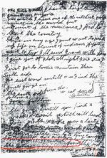
Don Peralta's 1864 Letter to Jacob Waltz

Oroblanco

Gold Member
Jan 21, 2005
7,837
9,826
DAKOTA TERRITORY
Detector(s) used
Tesoro Lobo Supertraq, (95%) Garrett Scorpion (5%)
Thanks guys for the clarifications, it does help (me anyway) and agreed to what was posted earlier about that being an interesting spot to check (IdahoDutch's ravine or canyon near the uplift) as it does look like it could be highly mineralized. Really the only way to know for sure is the old boots on the ground method and I live 2000 miles away now and can't just go take a walk up to see. But hopefully others have and can share some pics? I am pretty sure I have never been in that canyon IdahoDutch is referring to so don't have any photos I could share.

Side thing to IdahoDutch - thanks anyway and I can empathize completely. I had taken literally hundreds of photos when I first started, and lost nearly all of them in a home fire back in '89. The few photos we did manage to salvage look like they are 300 years old from the water damage and getting roasted in a fire. When I first started my father in law told me to get pictures of everything and I did, but photos are not safe from fires. Anyway the point was I understand very well, in fact the best 'strike' we ever made in Alaska many years ago I only took three photos, and have zero of them today.

Please do continue sorry for getting off the rails so far there.
:coffee2: :coffee: :coffee2: :coffee2:
 

Loke

Hero Member
Mar 24, 2010
589
1,383
Republic of Texas
Primary Interest:
All Treasure Hunting
Skyhawk,
In the German clues, one has Waltz calling the ravine, his uplift. Something like.... 3,000 meters from the springs he liked to frequent, to his uplift.

With all due respect, but ... after this many years in the US, was Jacob still speaking about metres?
I have been here for 24 years, I still 'think' in metres, but if I have to convey distances to anyone, I use feet or yards or miles (alas *chuckles* - wish I could convert you guys to the metric system!! - apart for Oro, I always insists on metrics when I talk to him :-), drives him batty)
 

Last edited:

Idahodutch

Bronze Member
Sep 25, 2019
1,847
4,780
Idaho
Detector(s) used
Whites MXT
Gold Legend
Primary Interest:
Other
With all due respect, but ... after this many years in the US, was Jacob still speaking about metres?
I have been here for 24 years, I still 'think' in metres, but if I have to convey distances to anyone, I use feet or yards or miles (alas *chuckles* - wish I could convert you guys to the metric system!!)

Loke,
Maybe because it said meters, perhaps is partly why I remember it. It took me back for second when I first read it.

I have not checked to see which springs it might be. I think it's maybe 3000 meters from that uplift to that springs on up past East Boulder, where the cowboys took Ruth.. . . My mind draws a blank. Anyway, I should check when I get back.
Idahodutch
(I wanna say willow springs, but for some reason the bell isn't ringing).
 

Last edited:

Loke

Hero Member
Mar 24, 2010
589
1,383
Republic of Texas
Primary Interest:
All Treasure Hunting
For the uninitiated (and to save you from googling it), 1 yard = 0.9144 metres, ie 3000 metres is near enough 3300 yards which is just shy of 2 miles.
I must admit I do have a laugh every now and then when I see maps like 1:64xxx whatever. Back home we use 1:50,000 where 1cm (1/4") on the map is 500m (550 yds) on the ground. For closer-up, we use 1:25,000 or even 1:10,000. The metric system is incredibly attractive inasmuch as you just move the decimal point around. Sorry yall (getting off my box), I ain't gonna mention it again! Promise!
 

OP
OP
skyhawk1251

skyhawk1251

Sr. Member
Nov 9, 2018
311
669
Kingman, AZ
Detector(s) used
Fisher Gold Bug Pro
Primary Interest:
Prospecting
Glad things got sorted out, and that everybody is oriented now. Idahodutch's ravine is easy to overlook using Google Earth. Red Hills is a good starting point to find it. I, too, like Idahodutch's ravine. The geology looks promising, and its location is very close to Marsh Valley and the Mexican miners' encampment.
 

Idahodutch

Bronze Member
Sep 25, 2019
1,847
4,780
Idaho
Detector(s) used
Whites MXT
Gold Legend
Primary Interest:
Other
Glad things got sorted out, and that everybody is oriented now. Idahodutch's ravine is easy to overlook using Google Earth. Red Hills is a good starting point to find it. I, too, like Idahodutch's ravine. The geology looks promising, and its location is very close to Marsh Valley and the Mexican miners' encampment.

I think we are in good company. I'm pretty sure Waltz liked it too. :icon_thumleft:
Idaho Dutch
 

Oroblanco

Gold Member
Jan 21, 2005
7,837
9,826
DAKOTA TERRITORY
Detector(s) used
Tesoro Lobo Supertraq, (95%) Garrett Scorpion (5%)
For the uninitiated (and to save you from googling it), 1 yard = 0.9144 metres, ie 3000 metres is near enough 3300 yards which is just shy of 2 miles.
I must admit I do have a laugh every now and then when I see maps like 1:64xxx whatever. Back home we use 1:50,000 where 1cm (1/4") on the map is 500m (550 yds) on the ground. For closer-up, we use 1:25,000 or even 1:10,000. The metric system is incredibly attractive inasmuch as you just move the decimal point around. Sorry yall (getting off my box), I ain't gonna mention it again! Promise!

Not to throw a wet blanket on this whole idea BUT here is a soggy wet blanket for you. Jacob Waltz arrived in the USA well before the US Civil War. When he left Deutschland, Germany was NOT under the Metric system and was not until 1872. By that time Jacob Waltz had already sold his claims in the Bradshaws and had settled in Phoenix several years. Waltz would NOT have used meters to describe anything as it was almost certainly not the system he was familiar with.

Please do continue, sorry for that soggy blanket.

:coffee2: :coffee2: :coffee: :coffee2:
 

Idahodutch

Bronze Member
Sep 25, 2019
1,847
4,780
Idaho
Detector(s) used
Whites MXT
Gold Legend
Primary Interest:
Other
Not to throw a wet blanket on this whole idea BUT here is a soggy wet blanket for you. Jacob Waltz arrived in the USA well before the US Civil War. When he left Deutschland, Germany was NOT under the Metric system and was not until 1872. By that time Jacob Waltz had already sold his claims in the Bradshaws and had settled in Phoenix several years. Waltz would NOT have used meters to describe anything as it was almost certainly not the system he was familiar with.

Please do continue, sorry for that soggy blanket.

:coffee2: :coffee2: :coffee: :coffee2:

Hello Oro,
Excellent! Off the cuff, I would wonder if Julia Thomas (who supposedly provided the info) was schooled with the metric. If so, perhaps that would explain it :icon_scratch: :dontknow:
 

Loke

Hero Member
Mar 24, 2010
589
1,383
Republic of Texas
Primary Interest:
All Treasure Hunting
Not to throw a wet blanket on this whole idea BUT here is a soggy wet blanket for you. Jacob Waltz arrived in the USA well before the US Civil War. When he left Deutschland, Germany was NOT under the Metric system and was not until 1872. By that time Jacob Waltz had already sold his claims in the Bradshaws and had settled in Phoenix several years. Waltz would NOT have used meters to describe anything as it was almost certainly not the system he was familiar with.

Please do continue, sorry for that soggy blanket.

:coffee2: :coffee2: :coffee: :coffee2:

Ahhh - thank you! I did not realize that! I thought they had been metric ever since the Napolean era .. my bad!
 

somehiker

Silver Member
May 1, 2007
4,365
6,426
Primary Interest:
All Treasure Hunting
He would have been familiar with any locally used system where he purchased goods and supplies.....feet of rope for instance.
And Julia with yards of cloth, I would think.
 

sdcfia

Silver Member
Sep 28, 2014
3,648
8,863
Primary Interest:
Other
US Land surveyors in Waltz's time of course used feet and inches, but also frequently described their distances and annotated their plats with chains (66 feet) and links (7.92 inches) instead. Why? Because that's the way they did their observations in the field, using a Gunter's chain, which is 66 feet long divided into 100 segments. Nice way to throw off the unwary with your treasure map measurements.
 

PotBelly Jim

Hero Member
Dec 8, 2017
898
2,987
Primary Interest:
Other
For the uninitiated (and to save you from googling it), 1 yard = 0.9144 metres, ie 3000 metres is near enough 3300 yards which is just shy of 2 miles.
I must admit I do have a laugh every now and then when I see maps like 1:64xxx whatever. Back home we use 1:50,000 where 1cm (1/4") on the map is 500m (550 yds) on the ground. For closer-up, we use 1:25,000 or even 1:10,000. The metric system is incredibly attractive inasmuch as you just move the decimal point around. Sorry yall (getting off my box), I ain't gonna mention it again! Promise!

Loke, I wish you WOULD mention it again is it's a kind of important consideration for anyone using maps or coordinates? I use SI units and engineering notation at work (everything in powers of 3, 6, 9, etc), measurements in feet/nautical miles and geocoords for aircraft and ships, measurements in klicks or meters and UTM grid coords for ground troops/artillery, statute miles while driving…so even for a pretty dense guy like me, using all these different measuring systems is necessary and it can be done if you just stop and think about it.

In regards to maps, the standard USGS topo map in the US uses a 1:24,000 scale. This is not in inches, feet, meters, etc. It will work for any measurement system. Which is why they don’t specify one. For example, one centimeter will be 24,000 centimeters on the ground. One thumb-length will be 24,000 thumb lengths on the ground, or make whatever scale you want. One of what you’re measuring with will equal 24,000 of them on the ground. Naturally, it’s easiest as Loke points out to use centimeters because it can easily be converted to meters just by moving the decimal point. (1mm = 24m, 1cm = 240m)

The standard USGS 1:24,000 topo map has 1,000 meter grid squares on it. This is so you can use a MGRS or UTM grid overlay, and theoretically get up to 1 meter resolution on your map when taking or plotting coordinates. This coordinate can easily be converted into whatever flavor of geocoords works best for you.

One thing to keep in mind is that there is roughly a 2mm “printing” or offset error on a 1:50,000 map. This is pretty consistent as you go up in resolution to a 1:24,000 scale map. About 1mm on that. What I mean is that any feature on the map (peak, house, road) may be printed up to 1mm off from where it actually should be printed on the map.

This means anything on the map may actually be 24 meters off because of the possible printing error. Which is why I said you could “theoretically” get up to 1 meter resolution with a UTM grid coordinate…you really can’t because the map isn’t printed to provide that kind of resolution. It’s best to just stick with a 10 meter coordinate and not try to get any better than that when working with a 1:24,000 map.
 

Last edited:

Matthew Roberts

Bronze Member
Apr 27, 2013
1,131
4,955
Paradise Valley, Arizona
Primary Interest:
All Treasure Hunting
Not to throw a wet blanket on this whole idea BUT here is a soggy wet blanket for you. Jacob Waltz arrived in the USA well before the US Civil War. When he left Deutschland, Germany was NOT under the Metric system and was not until 1872. By that time Jacob Waltz had already sold his claims in the Bradshaws and had settled in Phoenix several years. Waltz would NOT have used meters to describe anything as it was almost certainly not the system he was familiar with.

Please do continue, sorry for that soggy blanket.


Oroblanco,

The term "meters" as sometimes appears in one of Waltz alleged remembrance is the best interpretation of what was said passed down through six or seven people so the actual quote could have been almost any unit of measure given the number of people who passed on the account.

However, if you study Prussian history closely it is clear Jacob Waltz would have been VERY familiar with metrics, especially if you are among those who believe him to have been the Jakob Walz of Burkhart and Goetz Oertel's research.

Best,

Matthew
 

markmar

Silver Member
Oct 17, 2012
4,117
6,259
Primary Interest:
All Treasure Hunting
Also you have to take in consideration how in Waltz -Gonzalez era all the clues which have directions and distances, were all done with approximation, using sun orientation for directions and sight skills for distances.
 

PotBelly Jim

Hero Member
Dec 8, 2017
898
2,987
Primary Interest:
Other
Also you have to take in consideration how in Waltz -Gonzalez era all the clues which have directions and distances, were all done with approximation, using sun orientation for directions and sight skills for distances.

Excellent point. It's not like they could break out their laser rangefinders to take distance measurements. We should probably look at the Ortiz letter's "35-40 meters" as "about a stone's throw".
 

markmar

Silver Member
Oct 17, 2012
4,117
6,259
Primary Interest:
All Treasure Hunting
And also, IMO, at the bottom of the letter, there are two different sentences which are not in the correct stream of the letter's words.These two sentences should be read as : " look ... 30-40 metters from the bottom " and " after you discover the mine destroy A... arrastra ".

1864.jpg
 

somehiker

Silver Member
May 1, 2007
4,365
6,426
Primary Interest:
All Treasure Hunting
US Land surveyors in Waltz's time of course used feet and inches, but also frequently described their distances and annotated their plats with chains (66 feet) and links (7.92 inches) instead. Why? Because that's the way they did their observations in the field, using a Gunter's chain, which is 66 feet long divided into 100 segments. Nice way to throw off the unwary with your treasure map measurements.

Somehow Steve, I just can't see myself packing a 66 foot long chain around.....just to look around for this lost mine, or that old hidden treasure out there. Can't imagine those who made any of these maps doing so either. Too far out of the box I think.
 

Attachments

  • I think.jpg
    I think.jpg
    92.3 KB · Views: 53

Oroblanco

Gold Member
Jan 21, 2005
7,837
9,826
DAKOTA TERRITORY
Detector(s) used
Tesoro Lobo Supertraq, (95%) Garrett Scorpion (5%)
Nobodie wrote
The letter is supposed to be TO Jacob.
Which by itself is odd if you think about it. Why would this friend be telling Jacob how to find the mine? I was pointing out that Waltz would be very unlikely to be using the metric system. I never said that Don Peralta (if real) wouldn't use the metric system, we don't know anything about this identity. :dontknow:

Matthew wrote
Oroblanco,

The term "meters" as sometimes appears in one of Waltz alleged remembrance is the best interpretation of what was said passed down through six or seven people so the actual quote could have been almost any unit of measure given the number of people who passed on the account.

However, if you study Prussian history closely it is clear Jacob Waltz would have been VERY familiar with metrics, especially if you are among those who believe him to have been the Jakob Walz of Burkhart and Goetz Oertel's research.

Best,

Matthew

When exactly did Jacob Waltz leave Prussia? I don't think it is even established/proven that he was from Prussia, he told the census takers he was from "Germany" not Prussia specifically.

People tend to stick with the measurement system they were raised to learn. Waltz might have been "familiar" with the relatively new (then) Metric system, but I find it highly doubtful that he would be using it and especially in the USA. As to why this Don Peralta would be using the metric system in a letter to Waltz dating to 1864 (maybe) it is puzzling at least. Why would this Don Peralta use metric measurements to his friend Jacob Waltz? Do you know of any instance where Waltz is known to have used the metric system?

Side thing but
However, if you study Prussian history closely <snip>
clearly you don't know me very well. :occasion14:

Marius wrote
Also you have to take in consideration how in Waltz -Gonzalez era all the clues which have directions and distances, were all done with approximation, using sun orientation for directions and sight skills for distances.

Amen brother and thank you for pointing this out. I think we can safely assume that all measurements given in sources from that era (and after) are human estimates, NOT measured distances.

:coffee2: :coffee2: :coffee: :coffee2:
 

Matthew Roberts

Bronze Member
Apr 27, 2013
1,131
4,955
Paradise Valley, Arizona
Primary Interest:
All Treasure Hunting
Hello Oroblanco,

To begin my post I do admit the "metric" reference could be the way someone remembered it being related to Waltz after 6 or 7 people had handed down the original story. I don't know if Waltz ever used metric but I know of no one who can say for sure he didn't.

Waltz growing up as a boy lived in a group of member states with their alliance (allegiance) to Freidrich Wilhelm III of Prussia. Waltz's state was Baden-Wurttemberg.
The Prussian-German wars with France between 1805 and 1813 and the Prussian reform of 1808 later put Waltz as a young man squarely in the middle of the metric system.
The Landwher and the Landstrum would have sealed the deal for Waltz to have used the metric system.
And if you believe Waltz is the Dutchman identified by Burkhart and Goetz Oertel there is no question he was completely exposed to the metrics.

As I said, I don't know and can't say for sure Waltz ever used the metrics but he certainly had verified opportunities to have been exposed to it.

Best,

Matthew
 

Last edited:

Top Member Reactions

Users who are viewing this thread

Top