LDWhitneyAuthor
Greenie
- Jan 20, 2023
- 16
- 9
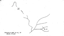
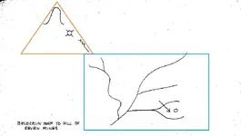
I was reading through an old issue of True West Magazine today, the June, 1955 issue to be exact, which boasts the cover story "60 Billion Dollars in Lost Gold". On page 8, author Ralph Coniston recounts a newspaper story about a man named Henry Brunderlin who followed a map to seven mine shafts in the foothills of the Superstitions which he claimed where the orignal Peralta Mines of Dutchman fame. The article in question is supposedly in a 1946 issue of The Denver Post. I did a search for "Brunderlin" put I didn't see any posts mentioning the man. Just curious if anyone has any information abou tthis event, or if it was even "real".