Are these very close to the heart carved out? Are there any steps or stairs nearby made of rock? If so perhaps the stairs represents "Jacob's Ladder". Ive also noticed a common occurrence when it comes to KGC/Jesse James/ and Gold, is that the markings is "at" or "near" US owned park. All the photos of carvings you've posted, are they located in the same area?
Are these very close to the heart carved out? Are there any steps or stairs nearby made of rock? If so perhaps the stairs represents "Jacob's Ladder". Ive also noticed a common occurrence when it comes to KGC/Jesse James/ and Gold, is that the markings is "at" or "near" US owned park. All the photos of carvings you've posted, are they located in the same area?
Well its according to which pictures you are reffering too. But the one that i posted with the chalked out pink heart is right beside a rock ladder. It actually has 2 places where they carved a rock ladder. But the one without the chalk. That heart doesnt have a rock ladder, but as a crow flies there is actually a place called jacob ladder. Its a rock ladder carved all the way up a bluff.
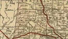
the symbols are definitely christian, so that would eliminate Chickasaw Indians. I would absolutely go to jacobs ladder , but first I would study old maps of the area from the mid to late 1800s. There is a ton of info on old maps! For example I pulled a map of Alabama from 1888, and in Marion Co Alabama there was a "Turtle Creek" perhaps its still called that today, but before going to jacobs ladder learn the names of the creeks, mills, etc. And weirdly enough there was an old town on that map called "Gold Mine" located in Marion Co Alabama. Im sure you know this is all speculation that Im saying here, some of these things can be interpreted 100 different ways! The diamond shape with the dot in the middle could be a good clue too! Perhaps if you climb jacobs ladder look over the landscape and see if there are 4 points to make a diamond over an area, then find middle of that diamond and see if there is anything there, you may be able to do that by looking at a topo map
the symbols are definitely christian, so that would eliminate Chickasaw Indians. I would absolutely go to jacobs ladder , but first I would study old maps of the area from the mid to late 1800s. There is a ton of info on old maps! For example I pulled a map of Alabama from 1888, and in Marion Co Alabama there was a "Turtle Creek" perhaps its still called that today, but before going to jacobs ladder learn the names of the creeks, mills, etc. And weirdly enough there was an old town on that map called "Gold Mine" located in Marion Co Alabama. Im sure you know this is all speculation that Im saying here, some of these things can be interpreted 100 different ways! The diamond shape with the dot in the middle could be a good clue too! Perhaps if you climb jacobs ladder look over the landscape and see if there are 4 points to make a diamond over an area, then find middle of that diamond and see if there is anything there, you may be able to do that by looking at a topo map
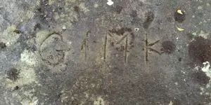
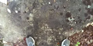
Thank you so much for taking the time out of your day to respond. But the diamond shape with the dot in the middle is atop of what we call state rock. An the carving with the chalk on them are about 1/4 -1/2 mile behind state rock.
The carving of the heart n cross with the circle in the middle is 5 miles nw in hodges alabama. The cowboy carving is also in hodges alabama. Close to what appears on the map called buzard bluff.
the symbols are definitely christian, so that would eliminate Chickasaw Indians. I would absolutely go to jacobs ladder , but first I would study old maps of the area from the mid to late 1800s. There is a ton of info on old maps! For example I pulled a map of Alabama from 1888, and in Marion Co Alabama there was a "Turtle Creek" perhaps its still called that today, but before going to jacobs ladder learn the names of the creeks, mills, etc. And weirdly enough there was an old town on that map called "Gold Mine" located in Marion Co Alabama. Im sure you know this is all speculation that Im saying here, some of these things can be interpreted 100 different ways! The diamond shape with the dot in the middle could be a good clue too! Perhaps if you climb jacobs ladder look over the landscape and see if there are 4 points to make a diamond over an area, then find middle of that diamond and see if there is anything there, you may be able to do that by looking at a topo
Well its according to which pictures you are reffering too. But the one that i posted with the chalked out pink heart is right beside a rock ladder. It actually has 2 places where they carved a rock ladder. But the one without the chalk. That heart doesnt have a rock ladder, but as a crow flies there is actually a place called jacob ladder. Its a rock ladder carved all the way up a bluff.
Local libraries with a genealogy section will usually have the best maps, they guy making the map would most likely be someone local, and would use names and titles according to the area.
I posted a link to the map, it hasnt been approved yet though. Another great tool I use and its free is gaiagps. It allows you to overlap old maps with new maps, so that you can determine the GPS. Its not 100% accurate, but it will put you in a 50ft radius of the spot your looking for. Atleast it does for me
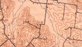
If you can get your hands on the 1899 topo map for your area you would be able to find where houses and other structures were located. Ill post an example of the one I have for my area. Each little square you see thats filled in, that represents where a house was. If it was just an outline of a square and not filled in, that would represent a barn etc