sdcfia
Silver Member
- Sep 28, 2014
- 3,649
- 8,865
- Primary Interest:
- Other
1) I don't see any connection between the two, and I personally wouldn't build a working model around Miller. French historic documents clearly validate a successful mining expedition into the headwaters region of the Arkansas River. Accounts from late 18th century Spanish Santa Fe also support investigations surrounding "illegal" French activities there.1) Never claimed it as factual. I'm operating under the assumption that both the LUE and the Treasure Mountain stories are legitimate. The stories sound a great deal alike if you compare reported recoveries (and searches) for the LUE with lore regarding the Treasure Mountain story. Both have multiple caching locations, both are in the same general area, both involve treasure signs, and I believe the Frenchmen's map may very well have been the LUE. I admit this is speculation, if I felt it were fact I wouldn't have posted multiple possibilities (as I interpret them). KvM also mentioned the Treasure Mountain story being well known under another name and having been published previously. These little bits add up, but I fully recognize it's a long way from conclusive. But in fairness, short of a recovery, none of this will ever be conclusive, least of all to someone who believes this is all a hoax to begin with.
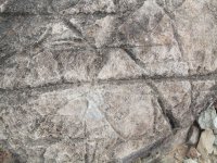
2) If you know Bob Brewer, you know he's a private man. I offered a suggestion but am not really at liberty to share much more. Bob firmly believes nearly all major treasure stories are KGC related, so this suggesting isn't earth shattering. How valid it is as a possibility, lies with the reader and their interpretation. If you've seen my video you have a good idea on how KGC symbology can be seen plainly on the map, the video also outlines concerns I have with how much different the LUE is compared to other types of KGC mapping styles.
3) Other than Victorio Peak, I don't know any large scale or well-known treasure stories that came out of the 1930s. Mostly what happened was existing stories, in many cases stories that were already 80 years old or more, became much more prominent. This seems as simple as broke Depression era folk chasing a dream. It's also worth noting, that "Trails of Spanish Gold" was allegedly published in this same time period and if ever found would predate Karl's influence on the LUE. I've long suspected that book was written by a CCC surveyor who was working in the same area as the LUE. Regarding KGC cover stories, I always found it odd that the KGC would plant false information when silence would work even better. Provoking people to look for a treasure they might accidentally find in the process seems strange when you could simply keep quiet and people would never be any wiser. Why draw attention, even false attention, to something you're trying to keep hidden in the first place? That said, doesn't large scale KGC lore also point to many of the treasures being moved in the 1920s and 1930s after maps and codes were discovered in a secret compartment in a traveler's foot locker?
PURE CONJECTURE: I don't think Karl was affiliated with the KGC, though he was indeed a Mason. I think it's far more likely he stumbled onto the map by accident. He came by the map (as I recall) in the late 1950s. KGC as a source of treasure wouldn't be exposed in large scale until the early 1970s with the publication of "Jesse James Was One of his Names." The person who had the LUE that Hardrock and Karl borrowed from likely didn't know what he had either or he wouldn't have lent it out.
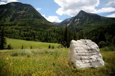
However, the LUE provides no hard facts or contemporary reports to support its existence. I've not settled on: who is responsible for the LUE, when it originated, where it originated (southern CO? northern NM?), and what exactly it is? If it was moved (reading between the lines of Miller's work), why? If it weren't for Miller, we likely would not be discussing the topic.
2) I generally support the Brewer/London camp as they describe the bigger picture. "KGC treasure site" symbology is not totally consistent. Remember, the original KGC prototypes basically operated from Civil War days up to just before WWI. After the Federal Reserve Bank took control of the USA in 1913, there was a sea change in the KGC (or whatever they later called themselves). Another sea change changed the game following the 1933 Gold Act. The "KGC treasure maps" and the field clues changed too, each time. The Mystery Glyphs and the more sophisticated clues and layouts replaced the early rebel, outlaw gang and cowboy symbology.
3) If you research most of the famous US treasure tales, you can fairly readily find out when they first came into public awareness. Yes, some came to light during the early days The Lost Dutchman is probably the best known, and Jacob Waltz's life prior to Phoenix certainly presents a KGC pedigree back in those days.
As you mentioned, a number of the "Organization's" earlier caches were moved when some of their secrets were revealed/stolen. How vulnerable they thought their caches had become is speculative, but it's not a bad bet to accept that many of those caches were relocated - likely in the same general locations as the originals. At this time (late 20s-30s, as I recall), new treasure tales and new field signs were created. These cover stories and clues are disinformation, IMO, and were cooked up to send the curious in circles until they either gave up the chase and quit, or simply died. As you pondered, it's my working model that those caches still exist, are recoverable and their owners silent. The Organization became more sophisticated.
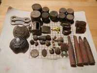
A new set of gold bar caches, not becoming well-known except in their own communities, appeared in the mid 1930s and were a direct result of melting down US gold coins, which became illegal to possess after 1933. This chicanery provided a plausible source for the loot - Spanish gold (of course), old Indian spoils being popular themes. These are the ones most sought after these days. Old newspapers are a good source for these stories (check those dates). Magazine articles and a few books followed.
Conjecture: I don't know who the hell Miller was. One guy who knew him claims he was a jokester (the LUE in particular). Some think he was a KGC disinformationist (Treasure of the Valley of Secrets). Many think he was God's gift to treasure hunters (newsletters, et al). Myself, I'm ambivalent and pay little attention to him.