Sorry if a RERUN !


Thanks Jeff, I have that article but never saw the pictures associated with it. More than a dozen claims in the Red River Gorge area over the years, I think I recall Boomer talking about this one...I believe he thought it was French in origin as there were no markings related to Swift near it.
This is the general area described in the article and by Boomer in a post. An Indian trace followed Indian Creek and through Wynn Branch. Link allows you to zoom and move the center of the map to get your bearings.
https://www.topoquest.com/map.php?l...nad83&zoom=8&map=auto&coord=d&mode=pan&size=m
I see there are a few you tube videos,
but not being personally familiar with the area, I have no idea if any refer to this mine
The article and at least one reply....well, I guess I should be nice. I reside in Menifee County, 30+ years.
There are several types of documented "mines" in Menifee County dating as far back as the late 1800's. Coal, salt peter, sandstone, limestone and iron ore. The article implies that RM Freeland was mining silver.....a little artistic license?
There are no mines "a few miles south of Frenchburg". I suppose the definition of "a few" is open to interpretation. The Red River Gorge is close but definitely more than "a few miles".
There are no mines protected by the Kentucky Historical Society, the KHS doesn't offer "protection" to any site in Kentucky. There are a handful of National Historic sites in Menifee but all are of Native American heritage with the exception of the old College Campus.
Kentucky Highway 40 isn't remotely close to Denniston, West Liberty or Frenchburg. Perhaps the author meant Route 460?
In all of my years living in Menifee, I've never heard of a rock with Welsh writing nor John Swift's old stone house being blown up. One of my close neighbors was Vern Spratt, he was obsessed with the John Swift legend. He spent a lot of time and money digging (heavy equipment) all over Menifee County. I can't tell you how many hours I spent listening to him, he could recite the Swift journal verbatim.
God bless him and may he RIP but Boomer did on several occasions provide misleading information and at least on one occasion, manufacture "evidence".
One thing that I've learned about folks believing in and searching for Swift's mines is that when one stumbles upon a mine, it's definitely a John Swift silver mine. When "normal" folks stumble upon a mine, it's an iron ore, sandstone, limestone, coal or salt peter mine. My hat is off to all of you that believe and search but you'll never find the mine based on the disinformation and mistakes that have been passed down for generations.

I hear the old Vern Spratt farm has grown over now? Is that true or does anyone live there today?
1320 most information on swift today is falacies there is good info on all of E. KY soon i hope to finish my book when i do release it i only ask everyone to read with an open mind then go back and review i believe you will be suprized at what i have learned in my pursuit of truth of the ledgon i am shure most will not believe until you check it out i believe you will ask yourself how did i miss it ?
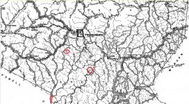
Thank you Ky Hiker, I stand corrected. I should have done some research before I started spewing. The article is dated 1936, the attached map is dated 1937. Clearly Rt 40 is correct. Notice the two mines (red circles). The mine on Rt 77 would be about (4 miles westward of Denniston. I haven't taken the time yet to see if one of them is the "quarry" on the topo map that you posted. Notice Indian Creek at the bottom of the map.
1320 although I tend to believe one who lives directly in the area about what may or may not be found there, I would like your opinion on the assay presented in this thread about a mine in your county. Thanks!
Yeah, I guess it could be forged but...
http://www.treasurenet.com/forums/l...ift/641356-thought-i-d-share.html#post6596319
I actually got a pretty good chuckle out of that "assay". The first thing that came to mind was I've never seen a assay that wasn't on some form or fashion of official company letterhead, even those dating back to the 1930's. The second thing that caught my attention was the title "US Assayer". As far as I know, there have never been an US Assayers doing field work, I believe official US Assayers worked for the various US Mints, I could be wrong. The third thing that got my attention was just the generally sloppiness of the typing and structure of the assay, it looks to have been drafted by someone that didn't have very good typing skills. It doesn't pass the "professional" test.
I didn't pay much attention to the actual claims stated in the assay until I reread it today, if that were in fact an honest assay, the guy was on to something. However, a 100 foot vein of unknown depth may not have even been one ton of material. I don't quite understand why there are multiple assays of silver within the same assay report. I didn't pick it apart too much, maybe save that for a rainy day.