Natural or Man Made?

EC.Mason

Hero Member
Feb 6, 2009
664
1,030
West Liberty Kentucky
Detector(s) used
Garrett AT Max
Primary Interest:
All Treasure Hunting
IMG_1159.JPEG IMG_1157.JPEG IMG_1124.jpg IMG_1124.jpg IMG_1177.JPEG IMG_1174.JPEG IMG_1174.JPEG
 

OP
OP
EC.Mason

EC.Mason

Hero Member
Feb 6, 2009
664
1,030
West Liberty Kentucky
Detector(s) used
Garrett AT Max
Primary Interest:
All Treasure Hunting
Hey hope everyone is well. These pictures were sent to me by a woman I work with. She used to own the property this is on. I have never been there. This is close to the Montgomery/Powell County line. Im anxious for some opinions on this! Im leaning toward natural because I cannot fathom what this would be in Kentucky.
 

galenrog

Bronze Member
Feb 19, 2006
2,016
2,203
The images alone makes a positive identification unlikely, even from some “experts”. Natural forces can make formations similar to this. Many thousands around the world have been found. Man has also made “roads” with a similar appearance.

What makes a man made road unlikely, in my opinion, is the lack of ruts made from decades of wagon travel. The base it is resting on looks wrong for most cultures that made stone roads. No bed preparation.

Of course, I could be wrong.

Time for more coffee.
 

Hal Croves

Silver Member
Sep 25, 2010
2,659
2,695
The images alone makes a positive identification unlikely, even from some “experts”. Natural forces can make formations similar to this. Many thousands around the world have been found. Man has also made “roads” with a similar appearance.

What makes a man made road unlikely, in my opinion, is the lack of ruts made from decades of wagon travel. The base it is resting on looks wrong for most cultures that made stone roads. No bed preparation.

Of course, I could be wrong.

Time for more coffee.

Nonsense.
Everything needed to identify this beautiful work of nature is found in those photographs.
Your second paragraph is spot on, however among other things, you missed the obvious lack of an in-sloped, out-sloped, or centerline-crown in the road.


Cheers!
 

Last edited:

Curtis

Hero Member
Sep 3, 2008
898
1,008
Cincinnati
Primary Interest:
All Treasure Hunting
Hi Mason,

Cool picture. It looks very even, odd as all get out. The top rocks are so nice and evenly spaced, the stuff they are imbedded in looks like its turned to a form of stone. Really old...maybe built be Indians or others, ?
 

GoDeep

Bronze Member
Nov 12, 2016
2,120
4,515
Detector(s) used
Whites, Garrett, Minelab
Primary Interest:
All Treasure Hunting
Edit: Hal Croves confidence makes me not so absolutely positive anymore. Vertical sections all lay parallel with parallel lines, uneven horizontal is so they can use unequal rock sizes and only have to cut two sides of the rock. Also, look at the side shots, they are layered, placed one on top of the other. It was likely laid over a swampy low section of the road.

Click to enlarge: rocks.JPEG
 

Last edited:

Hal Croves

Silver Member
Sep 25, 2010
2,659
2,695
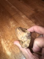
Absolutely positively man made. Vertical sections all lay parallel with parallel lines, uneven horizontal is so they use unequal rock sizes and only have to cut two sides of the rock. Also, look at the side shots, they are layered, placed one on top of the other. It was likely laid over a swampy low section of the road.

Click to enlarge: View attachment 1927564

An expert.
Gentleman's bet that you are absolutely, positively wrong.
 

GoDeep

Bronze Member
Nov 12, 2016
2,120
4,515
Detector(s) used
Whites, Garrett, Minelab
Primary Interest:
All Treasure Hunting
An expert.
Gentleman's bet that you are absolutely, positively wrong.

It was a road, and if you look closely, it's still being used as a road.(or perhaps more of a grand walkway / patio) regardless, notice the absence of any grasses or weeds growing up from all the cracks, its being maintained still to this day.

I'd even argue those pictures are from some central or south american mayan or aztec walkways/roadways.
 

Last edited:

Hal Croves

Silver Member
Sep 25, 2010
2,659
2,695
Sounds like a bet.
I am willing to back my opinion with cash, one hundred US dollars if you prove me wrong.
Just post the name of one professor of geology who agrees with you and identity the accredited university they work for.

Easy money.

Declarations are the fools flag GoDeep.
Try going deeper.

Cheers!
 

Hal Croves

Silver Member
Sep 25, 2010
2,659
2,695
Hi Mason,

Cool picture. It looks very even, odd as all get out. The top rocks are so nice and evenly spaced, the stuff they are imbedded in looks like its turned to a form of stone. Really old...maybe built be Indians or others, ?

Which Indians would that be Curtis and more importantly, specifically which draft animals were they using to pull their wheeled carts in Pre-Columbian America?
 

ArthurEvans

Jr. Member
May 10, 2016
27
35
Ulster County, NY
Detector(s) used
Garrett AT Pro, AT Max, Ace Apex;
Tesoro TejĂłn
Primary Interest:
All Treasure Hunting
Sounds like a bet.
I am willing to back my opinion with cash, one hundred US dollars if you prove me wrong.
Just post the name of one professor of geology who agrees with you and identity the accredited university they work for.

Easy money.

Declarations are the fools flag GoDeep.
Try going deeper.

Cheers!

+1 ...
 

GoDeep

Bronze Member
Nov 12, 2016
2,120
4,515
Detector(s) used
Whites, Garrett, Minelab
Primary Interest:
All Treasure Hunting
Here is wrapping around the corner. I suppose it could be some sort of hybrid, natural, but smoothed down and worked into a pathway / road but many of those look like rocks inlaid. You can tell it's used as such. It has to be some sort of park or what not. Clearly maintained, as it's weed free.

roadcorner.jpg
 

Last edited:

GoDeep

Bronze Member
Nov 12, 2016
2,120
4,515
Detector(s) used
Whites, Garrett, Minelab
Primary Interest:
All Treasure Hunting
Sounds like a bet.
!

Obviously my bluff is being called. It's clear to me you got the nuts and i'm just representing a big hand when in fact, it has little show down value. As such, i fold and will wait for a stronger hand.

I suspect you actually know where and what this actually is. It's clearly some sort of place that people regularly visit as it's being maintained.
 

Hal Croves

Silver Member
Sep 25, 2010
2,659
2,695
Obviously my bluff is being called. It's clear to me you got the nuts and i'm just representing a big hand when in fact, it has little show down value. As such, i fold and will wait for a stronger hand.

I suspect you actually know where and what this actually is. It's clearly some sort of place that people regularly visit as it's being maintained.

I don’t know anymore about the site location than has been shared, here on Tnet.

As I wrote, it’s natural and if you sit with the photographs long enough, everything one needs to reach the same conclusion is there, based on logical thinking. Dig in any direction and find the same.

Nature’s beauty is unsurpassed.

Cheers!
 

ArthurEvans

Jr. Member
May 10, 2016
27
35
Ulster County, NY
Detector(s) used
Garrett AT Pro, AT Max, Ace Apex;
Tesoro TejĂłn
Primary Interest:
All Treasure Hunting
I don't know anything about the site either, but I've seen plenty of boulder fields, and this looks like a not very weathered one. Also misleading is that it's pretty level - often these bedding planes are tipped, sometimes flipped, by other geological processes.

Also, if there was a Native American civilization in Ky that was building paved roads, we'd have heard of proportionate cities at opposite ends of them.

This is just a layer of rock - probably limestone - laid down level from its sedimentary beginning. Erosion opened it back up, and expansion/contraction from freezing and cooling created tiny cracks. Water starts to flow through, enlarging the gaps through erosion. Eventually it would end up as round boulders, but we happen to be seeing it just at the right moment for it to look deceptively like a road.

Here are a few sample pics of similar formations from around the world, from a web search on "jointed limestone erosion".

8E52C0F4-E65C-4A2D-97B1-0F42F7700F9B.jpeg 1598677A-662B-42FD-AAE6-EE805176D37F.jpeg 33AA5E9F-0710-447B-8F89-039B6906D441.jpeg 24E6E8EB-C3E4-449E-B415-D4AB759C6226.jpeg 54D91423-BE5E-44DB-891D-D9CB2C4B4380.jpeg 3A711BAE-27E8-4DDA-B0B6-7E8E8984A630.jpeg
 

Top Member Reactions

Users who are viewing this thread

Top