Perdido bay Shipwreck

G.I.B.

Gold Member
Feb 23, 2007
7,187
8,537
North Central Florida
🏆 Honorable Mentions:
1
Detector(s) used
CTX 3030 / GTI 2500 / Infinium LS / Tesoro Sand Shark / 1 Garrett Pro-pointer / 1 Carrot / Vibra Probe 580 (out on loan) / Lesche M85 / Mark1 MOD1 EyeBall
Primary Interest:
Other
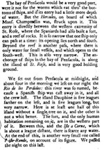
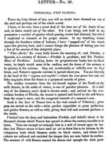
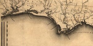
Below is a page from a book I've been using for some associated research. It was a letter written in 1722 by a French traveller. He was making his way to Mobile after being shipwrecked and traveling up the west coast of Florida June 1722.

From his descriptions he is obviously speaking of the Perdido River that separates Alabama and Florida. The Spanish shipwreck obviously occurred some years prior. I'm just curious at this stage, if anyone knows the name of the stricken vessel or the story that goes along with it.
 

Attachments

  • Perdido Bay.jpg
    Perdido Bay.jpg
    108.2 KB · Views: 1,947

MichaelB

Sr. Member
Aug 13, 2005
463
95
Mobile Bay, Alabama
He mentions Dauphine Island which was also known as Skeleton Island by the Spanish. He describes it as 5 leagues which is 15 nau miles with a fort at the western end. I have been all over Dauphin Island and as far as I know the only forts have been at the Shell mounds (central island) and the eastern end which has fresh water......curious.

MichaelB
 

Attachments

  • dauphin island sat1.jpg
    dauphin island sat1.jpg
    20.5 KB · Views: 1,712

ivan salis

Gold Member
Feb 5, 2007
16,794
3,809
callahan,fl
🏆 Honorable Mentions:
1
Detector(s) used
delta 4000 / ace 250 - used BH and many others too
St Rose is (santa rosa island)- the spanish name for the island--modern day pensicola bay is the area where he was talking about-- there a 2 wrecks talked about --the hercules "stuck" near the fort on Santa Rosa and the spanish vessel cast away "lost or sunk" in the river (might be upriver a bit or might be near the river mouth--area) Ivan p.s. ---remember the old spanish league was 2.6 miles --- the english league was 3 miles--later on the spanish "adopted" the english measure of 3 miles ----so if a measurement does not seem to "add" up correctly using the standard 3 mile league try using the "old" spanish 2.6 miles instead you might be very surprized at the "differance" --- Ivan
 

ivan salis

Gold Member
Feb 5, 2007
16,794
3,809
callahan,fl
🏆 Honorable Mentions:
1
Detector(s) used
delta 4000 / ace 250 - used BH and many others too
here are several pre 1722 possibles---

(1) in 1553 spanish fleet "Armada de Tierra Firme"*--commanded by Capt. Bartolome Carreno --reportly lost some vessels from the fleet some are reportly wrecked near present day mobile -- fla panhandle area-(note this would be prior to them joining the main fleet in havana--making them west coast wrecks)--also there are notes in some 1554 spanish archive records stating that 3 vessels carrying treasure were lost at 26 degrees 30 min (near captiva island?) wrecked near Rio Plamas (palm or palms river?) it is worth noting that 26 degrees 30 min if looked up on the west coast is "right" on the edge ofthe "big pine" aquatic preserve area on captiva island and I see no close by river--also noted in other 1554 records are the following--a nao (ship) owned by Sr. Bolanos that was part of the "armada"* the "Santa Maria del Camino" was fully salvaged --- she might have been one of the three "lost" ships---the other two maybe "San Estevan"-- 220 tons ---capt francisco del mecerno or (mercesno) coming from mexico---and the "Sancta Maria de Ycair" --200 tons-- capt alonso ozosi --owned by miguel de jaurrequi ---this ship was also coming from mexico-- these two are as far as I know unaccounted for. if as I think the shipwrecks are east coast wrecks--then 26 degrees and 30 min would "place" them around the gulf stream golf course area --in gulf stream,fla alot depends on weither or not they joined up with the main fleet in havana before their loss (thus east coast) or sank in route to join up---(west coast) with the "river of plamas" thing ---I'm thinking east coast (we even call it the "palm coast" these days) on these 2 wrecks myself--however the other ones below are west coast wrecks for sure

(2) 6 ships--1559--commanded by Don Tristan de Luna y Arelano lost due to hurricane near pensacola bay ---earlier in the year colonist were placed in the pensacola area by him but the hurricanes stopped the colony from being successful---the remaining survivors were removed in 1561 after nearly starving to death--they wound up eating their horse's and even the saddles for the horses as food---

(3)--Santa Ana Maria Jumcal-- commanded by Capt General Marguis de Cadereyata---recorded in spanish records as going down at "cabo de Apalachi"* on june 2, 1611 with several million in treasure ---*traslates to mean "cape (or point) of Apalachi" the spanish often named areas after the "local" indain tribes located in those areas---note this very well could be off what today is known as "cape san blas" or may be in / around the modern day Aplachicola area

good luck ---Ivan
 

pcolaboy

Hero Member
Sep 5, 2006
916
14
Pensacola, Fl
Detector(s) used
Minelab Explorer XS
Great information....I may be able to shed some more light.

First, the author mentions an inlet to the west of Pensacola Pass which is undoubtedly Perdido Pass that would naturally run southwest to northeast as the author mentioned but modern sea walls have prevented this. Many many years ago, Perdido Bay was simply referred to as Perdido River even though the mouth of this actual freshwater river lies 16 miles further up Perdido Bay from the inlet.

While fishing most of my life in Perdido Bay, my grandfather would repeatedly tell me about a legend his father had told him. He said there was an old hermit who lived in a very remote part of Perdido Bay back in the early 1800's. Every morning for several years the old man was observed leaving his large waterfront cabin rowing his long boat up Perdido Bay to the same spot taking only ropes, grappling hooks, and finely meshed oyster rakes. Every evening the man and his boat would return weighted down much more so than when he left. The few people living in the area at that time (1850's) said the hermit only went to town on horseback every few weeks but never with any oysters to sell. This behavior went on for several more years until the old man drowned when his boat capsized during a violent thunderstorm. A local government official escorted the man's only son to his father's property to collect personal effects and to determine what he wanted to do with the property which at that time was very remote and inhospitable. When they entered the hermit's cabin, they were astonished to discover piles and piles of lavish furnishings such as silver sets, fine china, stoneware, and other oppulent wares that had no business being in a hermit's cabin. Allegedly, there were several crates of additional wares that appeared to have marine growth on them. Unfortunately, the son gathered up these items, auctioned the property, and returned to his home in Georgia with the loot his father presumably recovered. No mention of coinage or bars in the legend which I would have serious doubts about anyhow.

Knowing how shallow Perdido Bay is, I know that whatever ship wrecked in there had to have a draft less than 12 feet to be practical. There were several key places along Perdido Bay and Perdido River that would have been likely reasons for a stores ship to be in there. One that comes to mind immediately was the old Spanish ferry that ran from present-day Blue Angel Millitary Recreation Facility (formerly NAS Bronson Field ) on the east shore to Suarez Point on the west shore which is then on Alabama soil. This ferry filled the gap on the very early Pensacola-Mobile road. There were also a few early logging operations up the actual Perdido River to retrieve Cyprus and Cedar timber which was very abundant at that time.

Here is a Google Earth KML file with the points of interest:


Also here is an excerpt from Wikipedia on Perdido Bay that refers to a famous Spanish map maker, Siguenza, getting lost in Perdido Bay but not wrecked:

"In 1693 noted cartographer and scientist Don Carlos Siquenza was sent by the Spanish government to locate the entrance. Even after he located the mouth of the bay, he was still unable to find a waterway deep enough to sail through. According to legend Siquenza's ship had been blown off course as he was again searching for the pass into the deep inland waters. The ship was spotted by an Indian Chief camped with his tribe at Bear Point.As the chief was walking along the water he spotted Don Carlos Siquenza attempting to reef his sails and offered to guide Siquenza and his men to a connecting deep water channel from the Gulf of Mexico into the more tranquil bay.When the search party finally located the elusive bay they called it Perdido which in Spanish means lost or hidden."

You can bet your last dollar I will be following up on this now that I have a side imaging sonar. I will certainly update on what, if anything, that I find.

MichaelB....give me a holler and lets get on up there to check it out.

Pcolaboy
 

Attachments

  • Perdido Wreck.kml
    11.3 KB · Views: 378
OP
OP
G.I.B.

G.I.B.

Gold Member
Feb 23, 2007
7,187
8,537
North Central Florida
🏆 Honorable Mentions:
1
Detector(s) used
CTX 3030 / GTI 2500 / Infinium LS / Tesoro Sand Shark / 1 Garrett Pro-pointer / 1 Carrot / Vibra Probe 580 (out on loan) / Lesche M85 / Mark1 MOD1 EyeBall
Primary Interest:
Other
I've looked at the modern maps of the river. They have an 'old' river channel to the east of the present day inlet which may have shoaled over during a hurricane sometime past.

I've not seen any old charts or maps of that era that show a different location for an entrance, but I'm still looking.

The old hermit story may have some merit to it. Rumors and 'tales' generally seem to have some amount of truth to them, albeit minuscule sometimes. What do the local historians have to say about the naming of the bay?

pcolaboy said:
"In 1693 noted cartographer and scientist Don Carlos Siquenza was sent by the Spanish government to locate the entrance. Even after he located the mouth of the bay, he was still unable to find a waterway deep enough to sail through. According to legend Siquenza's ship had been blown off course as he was again searching for the pass into the deep inland waters. The ship was spotted by an Indian Chief camped with his tribe at Bear Point.As the chief was walking along the water he spotted Don Carlos Siquenza attempting to reef his sails and offered to guide Siquenza and his men to a connecting deep water channel from the Gulf of Mexico into the more tranquil bay.When the search party finally located the elusive bay they called it Perdido which in Spanish means lost or hidden."

You can bet your last dollar I will be following up on this now that I have a side imaging sonar. I will certainly update on what, if anything, that I find.

What I find interesting here is the differing accounts of how the 'lost' river got its name. It's casually mentioned in the original letter I posted as if very common knowledge, and not tough to navigate by. I suppose I'll have to start 'digging' up a little more on this area.

Ivan, as always, I'm impressed by your knowledge base.
 

ivan salis

Gold Member
Feb 5, 2007
16,794
3,809
callahan,fl
🏆 Honorable Mentions:
1
Detector(s) used
delta 4000 / ace 250 - used BH and many others too
thanks ---I seem to remember reading somewhere there that the "lost" river is named that because of a lost ship and any the crew that survived the wreck were afterward wiped out by local indains--- not a very "freindly" bunch of indains to "strangers"----trying to sort out which ship it was ---the story I remember but where did I read it? ---as always so much info to sort thru----p.s. it was a rather bad area to navigate long ago because of these two reasons it was not a well liked area---- the first was the shallow waters (if a sudden "summer" storm should hit) while the ship was in the shallows it could be easily wrecked ---the second was because of very hostile local tribes who might kill off the crew if they shipwrecked---Ivan
 

pcolaboy

Hero Member
Sep 5, 2006
916
14
Pensacola, Fl
Detector(s) used
Minelab Explorer XS
"Old River" as marked on present-day maps was the only navigable path to Perdido Bay from the inlet which coursed to the east and then back around to the northwest. With the average depth of Perdido Bay being around 10 feet, I still contend that whatever craft the Frenchman was referring must have been very shallow draft to even make it to the river at all. The river itself has some pretty deep channels but like I said, the path from the inlet to the river is very shallow. There have been several instances over recorded history where the inlet itself was impassable due to hurricane surges and the actual location of it varied by hundreds of yards. A good example of how this can happen can be found by looking at the current state of Phillips Inlet which is about 5 miles northwest of Panama City Beach ( 30°15'57.50"N, 85°59'29.28"W). My grandfather used to visit a fish camp there when he was a boy and there was a fully passable inlet there at that time, but as you will see on Google Earth, there's barely even a trickle making it to the Gulf now.

With regard to Don Carlos Siguenza's expedition, he most certainly survived this incident and went on to produce several accurate charts of Pensacola, Escambia, Blackwater, and Choctawhatchee Bays among others. In fact, when the Presidio Santa Maria de Galve was established in 1698 at the present-day Pensacola Naval Air Station, the western tip of Santa Rosa Island was named Punta de Siguenza (Siguenza Point) where a small water battery was also established to defend Pensacola Pass. This is where Fort Pickens resides today.

No matter what the circumstances, I can assure that no large craft would have made it into Perdido Bay with a draft greater than 10 feet. Therefore it could be deduced that whatever ship perished in the river or bay would have most likely been something like a fragata, or caravel class. I know the waters of Perdido River, Perdido Bay, Old River, and Wolf Bay like the back of my hand and to this day you have to be very mindfull of the depth in any given location. I'm going to get out there with my side imaging unit and try to find something in the likely places.

Pcola
 

pcolaboy

Hero Member
Sep 5, 2006
916
14
Pensacola, Fl
Detector(s) used
Minelab Explorer XS
ivan salis said:
here are several pre 1722 possibles---

(1) in 1553 spanish fleet "Armada de Tierra Firme"*--commanded by Capt. Bartolome Carreno --reportly lost some vessels from the fleet some are reportly wrecked near present day mobile -- fla panhandle area-(note this would be prior to them joining the main fleet in havana--making them west coast wrecks)--also there are notes in some 1554 spanish archive records stating that 3 vessels carrying treasure were lost at 26 degrees 30 min (near captiva island?) wrecked near Rio Plamas (palm or palms river?) it is worth noting that 26 degrees 30 min if looked up on the west coast is "right" on the edge ofthe "big pine" aquatic preserve area on captiva island and I see no close by river--also noted in other 1554 records are the following--a nao (ship) owned by Sr. Bolanos that was part of the "armada"* the "Santa Maria del Camino" was fully salvaged --- she might have been one of the three "lost" ships---the other two maybe "San Estevan"-- 220 tons ---capt francisco del mecerno or (mercesno) coming from mexico---and the "Sancta Maria de Ycair" --200 tons-- capt alonso ozosi --owned by miguel de jaurrequi ---this ship was also coming from mexico-- these two are as far as I know unaccounted for. if as I think the shipwrecks are east coast wrecks--then 26 degrees and 30 min would "place" them around the gulf stream golf course area --in gulf stream,fla alot depends on weither or not they joined up with the main fleet in havana before their loss (thus east coast) or sank in route to join up---(west coast) with the "river of plamas" thing ---I'm thinking east coast (we even call it the "palm coast" these days) on these 2 wrecks myself--however the other ones below are west coast wrecks for sure

(2) 6 ships--1559--commanded by Don Tristan de Luna y Arelano lost due to hurricane near pensacola bay ---earlier in the year colonist were placed in the pensacola area by him but the hurricanes stopped the colony from being successful---the remaining survivors were removed in 1561 after nearly starving to death--they wound up eating their horse's and even the saddles for the horses as food---

(3)--Santa Ana Maria Jumcal-- commanded by Capt General Marguis de Cadereyata---recorded in spanish records as going down at "cabo de Apalachi"* on june 2, 1611 with several million in treasure ---*traslates to mean "cape (or point) of Apalachi" the spanish often named areas after the "local" indain tribes located in those areas---note this very well could be off what today is known as "cape san blas" or may be in / around the modern day Aplachicola area

good luck ---Ivan

I'm aware of these also and have a few things to add to each:

(1) The Pensacola Bay area was recorded as first visited by Ponce de Leon on the last leg of his Florida Gulf Coast expedition in March of 1513. Later in 1516, Diego Miruelo developed a very crude map of Pensacola Bay with a few soundings and also showed a non-specific body of water to the northwest which could only be Perdido Bay. Pensacola was used as a watering port, especially during the hurricane prone months, prior to its first attempt of settlement by DeLuna in 1559. During these months, fleets leaving Veracruz for Havana often followed the coastline of Gulf northward, eastward, and finally southward. This certainly does make a good arguement for some of Carreno's ships being in this area.

(2) There were actually seven ships that DeLuna lost, according to his own account, and were all lost in Pensacola Bay during that hurricane in September 1559. The Emmanuel Point shipwreck in Pensacola Bay, is one of those seven ships. It grounded and broke up in 14 feet of water during the storm. Here is a link to the UWF archaeology project for it: http://uwf.edu/anthropology/research/emanuel.cfm

(3) I read about this in Steven Singer's book as well. I have heard it mentioned that Cabo de Apalachi (also variously spelled Apalachie, and Apalachee) was believed to be Cape St. George a few miles southeast of Cape San Blas. The Port St. Joe area did not have nearly the abundance of good fresh water as the Apalachicola, Panacea, Carabelle, and the St. Marks areas did. Indian Pass, on the northern side of St. Vincent Island and West Pass between St. Vincent and St. George Island are naturally deep inlets. Since there was not a Spanish mission in the area until 1633, I wander if this fleet was simply skirting the coast and were driven ashore during a storm or attempting to obtain safe harbor from a storm.

Sorry for beating this topic to death but I'm obviously very 'invested' into it since this is my neck of the woods. ;D

Pcola
 

ivan salis

Gold Member
Feb 5, 2007
16,794
3,809
callahan,fl
🏆 Honorable Mentions:
1
Detector(s) used
delta 4000 / ace 250 - used BH and many others too
some of the vessels carried "smaller vessels" upon them---large flat bottomed shallow draft type mini vessels--often called scallops --- these flat bottom boats were often used to transfer stores and put on / take of cargo or lightering (removing cargo into the smaller vessel let the ship become shallower in draft---thus allowing it to more into shallower waters if needed to when the ship returned to deeper waters the cargo was reloaded upon the main vessel) as it was called or as a form of lifeboat in case of shipwrecks or for exploring inland areas---the vessel "lost" might have been one of those not the main vessel itself---Ivan
 

OP
OP
G.I.B.

G.I.B.

Gold Member
Feb 23, 2007
7,187
8,537
North Central Florida
🏆 Honorable Mentions:
1
Detector(s) used
CTX 3030 / GTI 2500 / Infinium LS / Tesoro Sand Shark / 1 Garrett Pro-pointer / 1 Carrot / Vibra Probe 580 (out on loan) / Lesche M85 / Mark1 MOD1 EyeBall
Primary Interest:
Other
Pcolaboy, I'm sending you some documents via PM that detail a little more concerning St. Joseph. You should find them interesting. They document some of the smaller vessels Ivan speaks of, and the history of the area. I've also seen some very interesting accounts of DeSoto and follow on expeditions into your area. It's turning into quite a story.

Cheers
 

pcolaboy

Hero Member
Sep 5, 2006
916
14
Pensacola, Fl
Detector(s) used
Minelab Explorer XS
GuyInBack....

I just sent you an email from my home email address. That is very kind of you to send it to me.

Pcolaboy
 

OP
OP
G.I.B.

G.I.B.

Gold Member
Feb 23, 2007
7,187
8,537
North Central Florida
🏆 Honorable Mentions:
1
Detector(s) used
CTX 3030 / GTI 2500 / Infinium LS / Tesoro Sand Shark / 1 Garrett Pro-pointer / 1 Carrot / Vibra Probe 580 (out on loan) / Lesche M85 / Mark1 MOD1 EyeBall
Primary Interest:
Other
Pcolaboy, documents on the way.

Additionally, I've been looking at present day navigation charts of your area. Then I've compared them to one of Bernard Romans charts from the late 1700's. Here are the screen shots.

I'm just guessing here but the river appears to have run directly out the east side. With a more direct flow, the channel could have been much deeper allowing the Spanish to become 'lost' up the river as stated in the earlier journal entry, whence the name for this place.

Anyhow, a hurricane or 20 over the years shoaled over the eastern entrance. The water forced it's way out the western, or present day, entrance. In doing so the river shoaled up and became much shallower as due to the decreased flow and change in direction.

I'm beginning to like the hermit story more and more...
 

Attachments

  • Perdido 1.jpg
    Perdido 1.jpg
    90.4 KB · Views: 2,110
  • Perdido 2.jpg
    Perdido 2.jpg
    72.1 KB · Views: 1,961

pcolaboy

Hero Member
Sep 5, 2006
916
14
Pensacola, Fl
Detector(s) used
Minelab Explorer XS
Thanks for the files Guy ! Hopefully the wife and kids will give me a chance to go through it :-)

Like I mentioned before, the location of this inlet used to be highly variable. I took the wide angle map shot that you included above and overlayed it on Google Earth adjusting for compass deviation. Everything matched up fairly perfect in terms of upper Perdido Bay and Pensacola Bay. It appears as though the creator of the map took the liberty of squeezing in Mobile Bay out of scale. The change in inlet location is nearly 3/4 of a mile. The Frenchman mentioned in the article that the inlet ran from southwest to northeast which would seem to be similar to present day. I suspect that the sw-ne course is probably geographically preferred path, but when a hurricane blows through the island to the waterway I'm sure it takes decades for nature to resume its path of least resistance. Pretty awesome when you think about it.

Man.... we may discover Atlantis if we keep this collective brain going! ;D

Here is another coastal survey from 1861 that shows a path similar to the present day course.

perdido1861.gif

Keep 'em coming...and I'll do the same.

Pcolaboy

GuyInBack said:
Pcolaboy, documents on the way.

Additionally, I've been looking at present day navigation charts of your area. Then I've compared them to one of Bernard Romans charts from the late 1700's. Here are the screen shots.

I'm just guessing here but the river appears to have run directly out the east side. With a more direct flow, the channel could have been much deeper allowing the Spanish to become 'lost' up the river as stated in the earlier journal entry, whence the name for this place.

Anyhow, a hurricane or 20 over the years shoaled over the eastern entrance. The water forced it's way out the western, or present day, entrance. In doing so the river shoaled up and became much shallower as due to the decreased flow and change in direction.

I'm beginning to like the hermit story more and more...
 

pcolaboy

Hero Member
Sep 5, 2006
916
14
Pensacola, Fl
Detector(s) used
Minelab Explorer XS
Here is some interesting data obtained from a study done by the Federal Minerals Management Service on the coastal erosion patterns in the area of Perdido Pass to give you and idea what the non-hurricane erosion rate is alone.

"The net longshore sand transport rate for the Morgan Peninsula was determined bycomparing cells of erosion and accretion in the littoral zone (seaward to 6-m depth contour [NGVD])between Perdido Pass and Main Pass (Mobile Bay entrance) in a sediment budget formulation. Thenet transport rate for that portion of the study area was determined to be approximately 106,000m3/yr to the west . Net transport rates determined via sediment transport modeling ranged fromabout 50,000 to 150,000 m3/yr. These rates compare well and provide a measured level ofconfidence in wave and sediment transport modeling predictions relative to impacts associated withsand dredging from proposed borrow sites."

How much is 106,000 cubic meters some may ask? Answer: Enough to fill an entire SuperWalmart to the ceiling or fill 10000 avergage sized dump trucks.

This certainly lends credibility for the huge difference in location of the pass from the 1700's map you posted and the 1861 map that I posted.

The direction of this movement is also evident at Pensacola Pass where Santa Rosa Island has 'grown' westward several hundred yards since Fort Pickens was built in the 1830's. In addition, the eastern end of Perdido Key ,which is on the west side of Pensacola Pass, eroded several hundred yards westward that eventually swallowed up Ft. McRee with the help of the 1906 and 1926 hurricanes.The spot where this fort once stood is underwater 'in' Pensacola Pass today.

Pcola
 

ivan salis

Gold Member
Feb 5, 2007
16,794
3,809
callahan,fl
🏆 Honorable Mentions:
1
Detector(s) used
delta 4000 / ace 250 - used BH and many others too
yep --in florida tidal basin type areas SANDS SHIFT thats a fact--heck my 1769 map of nassau sound clearly shows there is only one island--- sandy isle---in nassau sound--- there is no no "bird" island at all---now if you look at a modern map of nassau sound from today---it has two islands ---sandy and bird-----todays "Bird Island" in 1769 was just a shallow oyster bed area---it caught down flow from the river and built up using silt from the river and shifting sands in the tidal area ---"sandy isle" has shrank a bit in size during that time just goes to show exactly what your saying is true----funny thing--- the 1769 map even says on it "to beware of rapidly shifting sands" when approaching the "channel" area --Ivan
 

OP
OP
G.I.B.

G.I.B.

Gold Member
Feb 23, 2007
7,187
8,537
North Central Florida
🏆 Honorable Mentions:
1
Detector(s) used
CTX 3030 / GTI 2500 / Infinium LS / Tesoro Sand Shark / 1 Garrett Pro-pointer / 1 Carrot / Vibra Probe 580 (out on loan) / Lesche M85 / Mark1 MOD1 EyeBall
Primary Interest:
Other
Below I’ve attached a couple pages from a collection of letters written in the early 1800’s. I believe this particular letter was written in 1832. The author is obviously a naturalist.

The interesting thing is his understanding of the naming of the Perdido River / Bay.

I tend to believe the earlier version, mid 1500’s is probably more accurate as it is closer on a timeline to the original naming of the river.

One great lead would be to try to find some record of the hermit, or the son. You probably have a nice fat galleon sitting under the sand, now you just have to figure out where…

The shifting sands do make sense. It’s amazing how as to how much the hurricanes a couple of years ago made most nautical charts of the barrier islands obsolete overnight.
 

Attachments

  • Perdido info1.jpg
    Perdido info1.jpg
    105.9 KB · Views: 1,178
  • Perdido info 2.jpg
    Perdido info 2.jpg
    115.9 KB · Views: 1,104
OP
OP
G.I.B.

G.I.B.

Gold Member
Feb 23, 2007
7,187
8,537
North Central Florida
🏆 Honorable Mentions:
1
Detector(s) used
CTX 3030 / GTI 2500 / Infinium LS / Tesoro Sand Shark / 1 Garrett Pro-pointer / 1 Carrot / Vibra Probe 580 (out on loan) / Lesche M85 / Mark1 MOD1 EyeBall
Primary Interest:
Other
The above mentioned account of the 3 ships (Galleons) sunk in 1554 off of Rio Palmas (Captiva/Sanybal Island) 26 degrees north has had me casting dock lines, stocking up on rum and hot dogs and getting ready to sail to Captiva. A little pre planning research made me retie the boat back at the dock for a bit.

In 1554 four vessels left to Spain independently, under the command of Antonio Corzo, a few weeks before the arrival of that year’s Nueva España fleet. But 20 days after they left Veracruz the fleet was caught by a hurricane and pushed towards the coast. Three of the four vessels sunk off Padre Island on April 29, 1554. Only the San Andres escaped, reaching Havana safely but so damaged that it had to be scrapped.

Of the 300 people aboard the San Esteban, Espiritu Santo, and Santa Maria de Yciar, half may have died in the shipwrecks. The survivors sent a small party of sailors south, in one of the ships’ boats, to call for help, and then organized a march along the beach, back to Mexico. They thought that they were much farther south, and that it would not take long before they saw people. However, they were very far from Mexico, and all except one died in the march.

A salvage expedition was sent as soon as the news of the disaster reached Veracruz, and recovered about half of the cargo from the 3 lost ships.

The site presumed to be the Santa Maria de Yciar was probably destroyed in the late 1940s by the U.S. Army Corps of Engineers. As they were opening the Mansfield Cut. Ship’s timbers, chains and anchors were caught up by the dredges…

The Espiritu Santo was found and salvaged by a group of treasure hunters in 1967, after a businessman from Indiana found coins along the beach and decided to search the sea.

The San Esteban was found by the Texas Antiquities Committee in 1973, and archaeologically excavated in the years that followed its discovery.

It’s interesting to note that Padre Island in Texas is N 26degrees 30’ and is the same as Florida’s Captiva / Sanibel Island.

There are lots of mentions on Google about Sable Palms near Padre Island, which may explain the Rio Plamas refrence. My electronic road map does not go into enough detail to find a river like that at 26 degrees north. Anybody else know the river?

Standing by at the dock for the next hot tip…
 

ivan salis

Gold Member
Feb 5, 2007
16,794
3,809
callahan,fl
🏆 Honorable Mentions:
1
Detector(s) used
delta 4000 / ace 250 - used BH and many others too
sorry did not know they were texas 26 30 wrecks--- I was thinking florida 26 30 --even then there would have been two possibly differant "spots", one the east coast and one on the west coast--- (after reading the wreck accounts ---I noted a "odd" thing that made me think---that they were lost before they reached havana --- the record said "from mexico" not "from havana" thus to me thats the tip off that they were lost "in route to havana"---otherwize the record would have said "from havana" --- losses were and still are recorded by the "last port" of call the ship made before it sank--lyold s of london basucally writes it down like so "queen anne" of london(bark) sailing vessel 350 tons (150x39x10) from liverpool--- bound for new york --carrying the crown jewels---estimated loss 5.000.00 pounds----this is basic "naval speak" and is the rather formal and has changed little to none through the years--Ivan
 

OP
OP
G.I.B.

G.I.B.

Gold Member
Feb 23, 2007
7,187
8,537
North Central Florida
🏆 Honorable Mentions:
1
Detector(s) used
CTX 3030 / GTI 2500 / Infinium LS / Tesoro Sand Shark / 1 Garrett Pro-pointer / 1 Carrot / Vibra Probe 580 (out on loan) / Lesche M85 / Mark1 MOD1 EyeBall
Primary Interest:
Other
This is a portion of a Map of Florida, Compiled and Drawn from various Actual Surveys & Observations by Charles Vignoles in 1823.

LOC call number G3930 1823 .V49

The map is not available electronically online. The map, in its entirety, appears very detailed and accurate. The Perdido Bay entrance appears on the east side, and is nice and wide. Just wide enough to let a fat treasure laden Galleon inside to hide from a hurricane or pirates.

It would appear that the channel changed course sometime between 1823 and 1861. Any hurricanes or earthquakes during that time frame that anyone may know about?

Ivan: Agreed, they (Padre Island wrecks) were probably bound for Havana where they would wait for the rest of the galleons and gang up before heading back to Spain. They basically followed the coastline from Mexico up and around LA and Fl then into Havana.

Maybe we have a lost one in Perdido Bay???

Harrrrr, I smell tesoro de la astilla del oro...
 

Attachments

  • Perdido Map.jpg
    Perdido Map.jpg
    70.4 KB · Views: 1,428

Top Member Reactions

Users who are viewing this thread

Top