Peter's Canyon, The Jeauits, and the Lost Dutchman

Doc4261

Hero Member
Nov 5, 2015
582
578
Primary Interest:
All Treasure Hunting
The LDM clues and the many variances of these clues after told thru the years are the reason this mine has not been found.. The Peralta stones, specifically the ones for the map and Heart inlay, show the Junction of Peters Canyon and Tortilla Wash, and above this junction are the signs to the mine. The Inlay shows Peters Canyon with the mine on the East side, facing West, like a Dutchman clue and the setting sun. The Mexican mule trail enters from the West, crosses Peters, over this hilltop, and then enters Tortilla heading South. This is the curve on the stone 'for this trail'. The hilltop has been 'cleared' to make the signs stand out so they could be seen from the mountain tops. These were made 180 years ago. A couple sketch maps line up as well to Peters canyon and this mine site. The 'symbols' I show are visible on Google Earth. The evidence of Mexican mining activity in here during the 1840s fits the stories as well. Apache massacre or US Territory, they had to leave. They made a point to document this rich mine. I understand
if this may not be the LDM, this is a Mexican mine that other than the miners, others spoke of due to its gold. Thier clues match the site as well. I have faith the Mexican miners were braving the elements and Apache, putting the work into signs on the hillsides and maps for future trips/generations, for a reason. I have seen this 'work' and 'question' why this effort was done if there are 'no minable' minerals here. Jacob Waltz mine may be West of Peters Canyon, but The Sombrero Mine, the mine of the Cave of Gold the Indian spoke of, and many of the 'true clues', including many of the Dutchman Mine, are at this spot East of Peters Canyon.
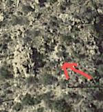
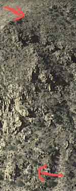
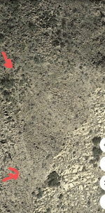
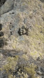
One to the east of peters mesa I can say myself, but 6 are to the west on the stone maps. All are north of weavers needle but the ones on the lower stone map. The ones on the lower stone map aren't too far from the ldm get together every yr. Reason of my ask of Mr. Mathews earlier was to see if Bilbery's mine-mines, could be the mine to the west. He can answer that with the knowledge he has, and my decipher of the skin- paper map that depicts the stones. I'm sure most know what map I'm talking bout.
Peters canyon holds el hoyo. Also not the ldm ,but that is a whole story by itself.
 

Last edited:

Doc4261

Hero Member
Nov 5, 2015
582
578
Primary Interest:
All Treasure Hunting
Thanks so much for taking the time to write all this. It made for an interesting read and i appreciate teh encouragment. I am not personally convinced that the Peralta Stones are anything but elaboarte fakes, and the stone crosses as well. I don't necessarily intend to be a slave to the established lore, but have included nods to these many moving pieces of Dutchman Legend for the informed reader. My interest in Peter's Canyon is because it fits the narrative better as well as serving as a more out of the way location with fewer hikers than the main trails and canyons. Last time I hiked the Superstitions, I saw numerouos groups of people enjoying the outdoors. Great to see, but its hard to have tourists interrupting action and intrigue all the time. hahaha
Want an twist , then figure why this stone x is in the area of peters mesa, canyon area. I've Always believe it held a key to one of the mines ties to el hoyo map ,hidden valley.
 

Attachments

  • Screenshot_20230203-205951.png
    Screenshot_20230203-205951.png
    227.3 KB · Views: 73

Doc4261

Hero Member
Nov 5, 2015
582
578
Primary Interest:
All Treasure Hunting
Want an twist , then figure why this stone x is in the area of peters mesa, canyon area. I've Always believe it held a key to one of the mines ties to el hoyo map ,hidden valley.

Want an twist , then figure why this stone x is in the area of peters mesa, canyon area. I've Always believe it held a key to one of the mines ties to el hoyo map ,hidden valley.
It's my belief this could be said mine below the X. Can see what seems to be a broken up area that shouldn't be there if ya follow the arrow I put to the upper left a half inch. Never been the so can't be sure. But intriguing for sure. I'm sure I'll never go there. Just to damn hard of a trip. 2nd pic orientation of x to said area. One can come to their own conclusion. The world may never know.. sounds like a toosie pop commercial. 🤷🤣
 

Attachments

  • Screenshot_20230203-210526.png
    Screenshot_20230203-210526.png
    361.6 KB · Views: 69
  • Screenshot_20230203-211842.png
    Screenshot_20230203-211842.png
    1.1 MB · Views: 67
Last edited:

ancientones

Full Member
Apr 16, 2010
102
105
It's my belief this could be said mine below the X. Can see what seems to be a broken up area that shouldn't be there if ya follow the arrow I put to the upper left a half inch. Never been the so can't be sure. But intriguing for sure. I'm sure I'll never go there. Just to damn hard of a trip. 2nd pic orientation of x to said area. One can come to their own conclusion. The world may never know.. sounds like a toosie pop commercial. 🤷🤣
doc4261 This is definitely a marker, white rocks on black background-forming an X. It stands out. IF Mexican it would be identifying a trail(X) which would pass 'right by' the X. The mine site would have similar signs: white rocks on black
and black rocks on white. Your ability to 'see' this X and other 'signs' on GE will become addicting, but rewarding.
NICE!
 

Doc4261

Hero Member
Nov 5, 2015
582
578
Primary Interest:
All Treasure Hunting
doc4261 This is definitely a marker, white rocks on black background-forming an X. It stands out. IF Mexican it would be identifying a trail(X) which would pass 'right by' the X. The mine site would have similar signs: white rocks on black
and black rocks on white. Your ability to 'see' this X and other 'signs' on GE will become addicting, but rewarding.
NICE!
What trail?? Lol
 

Attachments

  • Screenshot_20230204-081344.png
    Screenshot_20230204-081344.png
    747.5 KB · Views: 59

Doc4261

Hero Member
Nov 5, 2015
582
578
Primary Interest:
All Treasure Hunting
What trail?? Lol
Wanta see a very old trail marker. This is on the way to the ldm area. The trail stopped this pointed the way to go from there.
 

Attachments

  • Screenshot_20230204-082216.png
    Screenshot_20230204-082216.png
    557.7 KB · Views: 84
Last edited:

ancientones

Full Member
Apr 16, 2010
102
105
What trail?? Lol
To start, are you able to tell if miners coming into this area is there a known major trail-to get to your X. All the 'mine' trails will deviate from the 'main' trails. For the Sombrero mine area, they came in from the East around the North end of the mtn., North-going down Peters Canyon, and West(Peralts Stones). Below is part of this West trail. After crossing the hilltop above the junction of Peters/Tortilla, the trail heads up Tortilla. The 'green' dashes are this trail-you can see a faint 'line' just above my dashes. GE year 2007 seems to show 'more' of the trail signs and trails, but look at all the time zones from 2007 on. With 2007 you will see a 'X' trail symbol just below the trail. The 'yellow' dashes are a trail coming in from the NE, the 'Trail Marker' would advise them to 'look' for the direction of the trail. The 'scouts' would have seen the hillside symbols as well. Trails were few and the terrain difficult so looking at where the trail 'could' go is a good way to find them. Your pic looks like a trail running top left to bottom right.
1675524126263.png
 

Doc4261

Hero Member
Nov 5, 2015
582
578
Primary Interest:
All Treasure Hunting
To start, are you able to tell if miners coming into this area is there a known major trail-to get to your X. All the 'mine' trails will deviate from the 'main' trails. For the Sombrero mine area, they came in from the East around the North end of the mtn., North-going down Peters Canyon, and West(Peralts Stones). Below is part of this West trail. After crossing the hilltop above the junction of Peters/Tortilla, the trail heads up Tortilla. The 'green' dashes are this trail-you can see a faint 'line' just above my dashes. GE year 2007 seems to show 'more' of the trail signs and trails, but look at all the time zones from 2007 on. With 2007 you will see a 'X' trail symbol just below the trail. The 'yellow' dashes are a trail coming in from the NE, the 'Trail Marker' would advise them to 'look' for the direction of the trail. The 'scouts' would have seen the hillside symbols as well. Trails were few and the terrain difficult so looking at where the trail 'could' go is a good way to find them. Your pic looks like a trail running top left to bottom right.
View attachment 2067908
For the pics I posted. They woulda come from peters mesa. It's the only way.
 

Gary M Herndon

Jr. Member
Dec 22, 2022
60
44
Greetings everyone,

Quick introduction: my name is LD Whitney and I'm an author of fictional adventure thrillers. I'm researching for a novel that combines some of my favorite Arizona Legends about the Jesuits and the Lost Dutchman Mine.

While reading "the Sterling Legend" the author mentions on page 32 that Peter's Canyon fits a number of Dutchman Clues but not all (because none do). I see a lot of focus on Weever's Needle, La Barge Canyon, and so on, but why not Peter's?

I'm currently trying to work out some kind of clue that would lead my main characters to Peter's Canyon above the other well tread options.

Thoughts? Thanks in advance!
At one time, there were almost 185 clues to the LDM.... Thus saying You have 1 in 1 Million chance in finding the LDM with those clues. There are only 8 clues that are necessary
 

Doc4261

Hero Member
Nov 5, 2015
582
578
Primary Interest:
All Treasure Hunting
At one time, there were almost 185 clues to the LDM.... Thus saying You have 1 in 1 Million chance in finding the LDM with those clues. There are only 8 clues that are necessary
Only one map and a doodle is necessary.. No clues at all, If ya got the time to look. 🤔
 

Outrider43

Jr. Member
Dec 25, 2014
25
29
NW Ohio
Detector(s) used
Whites D6000, MXT All Pro and Fisher
Primary Interest:
All Treasure Hunting
Greetings everyone,

Quick introduction: my name is LD Whitney and I'm an author of fictional adventure thrillers. I'm researching for a novel that combines some of my favorite Arizona Legends about the Jesuits and the Lost Dutchman Mine.

While reading "the Sterling Legend" the author mentions on page 32 that Peter's Canyon fits a number of Dutchman Clues but not all (because none do). I see a lot of focus on Weever's Needle, La Barge Canyon, and so on, but why not Peter's?

I'm currently trying to work out some kind of clue that would lead my main characters to Peter's Canyon above the other well tread options.

Thoughts? Thanks in advance!
There is another treasure story involving the Jesuits. A man named Davy Davis found the remains of Jesuit church with gold religious items in the same area as the Lost Dutchman. The article was in a Arizona magazine with pictures taken by Davis. I was able to get them to send me a copy of the article with those pictures. A friend of his came by his camp to drop off supplies and take his camera to get the photos to be developed. The last photo was taken of a very large rain storm. Later he returned to Davis's camp site to find it was gone caused by a flash flood. The article is decades old but I may still have my copy. I will check back to see with you to see want it as an attached file.
 

ancientones

Full Member
Apr 16, 2010
102
105
At one time, there were almost 185 clues to the LDM.... Thus saying You have 1 in 1 Million chance in finding the LDM with those clues. There are only 8 clues that are necessary
Hello Gary,
My research shows the Mexican miners were finding mines South of Tortilla and East of Peters 1846/1847, with
this Sombrero found in 1847. There are 'several' mines on the East side of Peters. The 8 or so 'true' clues of his are here and I provided pics on my thread. The 'waterfall' below the mine, this makes a wash he panned from. There
is tailings here as well. The 'tunnel', funnel shaped pit, have to enter from the side. Based on my photo at this spot you see the 'crevice with the mine' just this side of the waist high white rock with oblong corner. When you exit the
mine/crevice you would see nothing-you are on the edge of a cliff. Vein running down the mtn. The mine is on a ledge on the East side of a South to North flowing canyon. Peters canyon zigzags at this spot. From a high point on this ledge you can see Weavers Needle 'due' South. The 3 square/rectangular white rocks above the mine. The 3/4 spheres or 3 Teepees. All of these are subject to the viewer and what they see. I see 60 to 70 clues between all the clue tellers so if you have a clue you are curious about I should have it.
Here is my favorite Dutchman clue: It lies within a 5 mile circle with Weavers Needle at its center. Some experts say its bogus, some say its valid. Some say this clue was told to Julia Thomas when he was dying and providing the clues, some say she went to fetch the Dr. and was not there when he gave his clues-he died before she got back with the Dr. I 'questioned' why he would say Weavers was in the center of a 5 mile circle when he said the needle was due South. Since everyone goes 2 1/2 miles North of the Needle I went 5. I matched enough clues on Google Earth including the Peralta Stone Maps(above junction of Peters and Tortilla), and then started finding the trails and symbols/signs from the Mexican miners to other mines in here. The Lost Dutchman obtained this mine from Mexican miners who found and documented this site, and then were massacred by the Apache or now US Territory and had to leave. Due to this mines richness, they came back.
Why does no one go to Peters? After 10 years of showing my material I have no answer-experts just advise me I am in the wrong spot, no minable minerals there. No doubt this was the richest mine here and why they came back to this mine, but it is not the only one in here.
Hope this helps and Thank you for your post
 

skyhawk1251

Sr. Member
Nov 9, 2018
311
669
Kingman, AZ
Detector(s) used
Fisher Gold Bug Pro
Primary Interest:
Prospecting
There is another treasure story involving the Jesuits. A man named Davy Davis found the remains of Jesuit church with gold religious items in the same area as the Lost Dutchman. The article was in a Arizona magazine with pictures taken by Davis. I was able to get them to send me a copy of the article with those pictures. A friend of his came by his camp to drop off supplies and take his camera to get the photos to be developed. The last photo was taken of a very large rain storm. Later he returned to Davis's camp site to find it was gone caused by a flash flood. The article is decades old but I may still have my copy. I will check back to see with you to see want it as an attached file.

122.jpg


123.jpg


124.jpg


125.jpg


126.jpg


127.jpg


This is how the tale is told in Thomas Penfield's book, "Dig Here!" There are other versions. It is most probably bogus and fabricated -- just another yarn spun about the Old West.
 

Outrider43

Jr. Member
Dec 25, 2014
25
29
NW Ohio
Detector(s) used
Whites D6000, MXT All Pro and Fisher
Primary Interest:
All Treasure Hunting
View attachment 2069512

View attachment 2069513

View attachment 2069515

View attachment 2069516

View attachment 2069517

View attachment 2069518

This is how the tale is told in Thomas Penfield's book, "Dig Here!" There are other versions. It is most probably bogus and fabricated -- just another yarn spun about the Old West.
The one story I refer to is titled The Mystery of Cerro Ruido by Norman G. Wallace. It covers the Group of missions built by Father Kino who was the first Jesuit Padre to explore Northern Sonora. The photos in the article were taken by David Davison.
 

OP
OP
LDWhitneyAuthor

LDWhitneyAuthor

Greenie
Jan 20, 2023
16
9
There is another treasure story involving the Jesuits. A man named Davy Davis found the remains of Jesuit church with gold religious items in the same area as the Lost Dutchman. The article was in a Arizona magazine with pictures taken by Davis. I was able to get them to send me a copy of the article with those pictures. A friend of his came by his camp to drop off supplies and take his camera to get the photos to be developed. The last photo was taken of a very large rain storm. Later he returned to Davis's camp site to find it was gone caused by a flash flood. The article is decades old but I may still have my copy. I will check back to see with you to see want it as an attached file.
That's a good find! Who did you contact to get a copy? I'm interested in reading this one for myself. Much appreciated, sir!
 

jeffhowlett

Jr. Member
Jul 17, 2017
31
27
Primary Interest:
All Treasure Hunting
Greetings LDWhitney,
Until his mine location can be found and 'verified', his clues may or may not be true. Those searching for his mine are searching in locations based on 2 of his clues, a South to North flowing canyon(Boulder/Needles/LaBarge), and you could see Weavers Needle due South. You are correct, 'why' not Peters Canyon as this 'fits' these 2 clues. Another clue of his advises his mine is within a 5 mi circle, with Weavers Needle at its center. What if the characters 'heard' it wrong or the provider of the clue purposely 'changed' a part of it and they went 5 miles due
North of Weavers Needle?
Fact or fiction, you have a Great storyline you are pursuing.
Never said Weaver's needle, only a peak.
 

Idahodutch

Bronze Member
Sep 25, 2019
1,848
4,785
Idaho
Detector(s) used
Whites MXT
Gold Legend
Primary Interest:
Other
Never said Weaver's needle, only a peak.
If you guys are talking about Bicknell’s S.F. Chronicle article, Jan of 1895 …
Then you maybe should read it again.

Both names are used in the article … Sombrero Butte, and also Weavers Needle.

Just getting things straight.
Please continue 😄
 

jeffhowlett

Jr. Member
Jul 17, 2017
31
27
Primary Interest:
All Treasure Hunting
First, that is what Bicknel wrote and not the first person or second person as to what Waltz said to be commonly believed to be accurate, but not guaranteed. Waltz says high peaks to the south, and really as far as Butte it was not in the Mexacans vernacular, so Bieknel who is regarded as not being accurate and also getting information d
from Julia Thomas who was thankfully a total incompetent( otherwise the mine may have been found). to add to this our editor is an English - Spanish professor who said that mid-nineteenth Mexicans would not have used the word, Butte. and technically it is not butte. however, Waltz's doodle is.
 

Top Member Reactions

Users who are viewing this thread

Top