pcolaboy
Hero Member
- Joined
- Sep 5, 2006
- Messages
- 916
- Reaction score
- 14
- Golden Thread
- 0
- Location
- Pensacola, Fl
- Detector(s) used
- Minelab Explorer XS
- #1
Thread Owner
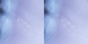
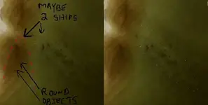
I was taking a look at the latest image set (post-Hurricane Katrina)that is now online for my area on Google Earth and noticed what appears to be another outline of a ship similar to the one I found back in May. This feature was not visible on any earlier Landsat or other aerial/space photography. The immediate area of this feature experienced a substantial amount of coastal erosion from the three major hurricanes that have effected us in the last two years.
The area where this mystery feature lies is absolutely ripe for a shipwreck due to its close proximity to Pensacola Pass. Please take a look at the photo below and offer your opinions.

If you take my general outlined shape into consideration, the rough dimensions are 184' x 55'. I am probably going to be doing a quick dive on this thing whatever it may be in the coming week.
Will keep you posted,
Pcolaboy
The area where this mystery feature lies is absolutely ripe for a shipwreck due to its close proximity to Pensacola Pass. Please take a look at the photo below and offer your opinions.
If you take my general outlined shape into consideration, the rough dimensions are 184' x 55'. I am probably going to be doing a quick dive on this thing whatever it may be in the coming week.
Will keep you posted,
Pcolaboy