Researching a Colonial Tavern - First Prospect of the Area

Terry Soloman

Gold Member
May 28, 2010
19,419
30,081
White Plains, New York
🥇 Banner finds
1
🏆 Honorable Mentions:
1
Detector(s) used
Nokta Makro Legend// Pulsedive// Minelab GPZ 7000// Vanquish 540// Minelab Pro Find 35// Dune Kraken Sandscoop// Grave Digger Tools Tombstone shovel & Sidekick digger// Bunk's Hermit Pick
Primary Interest:
Metal Detecting
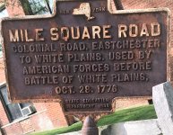
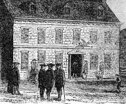
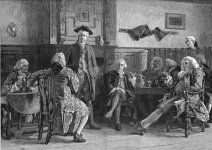
I have about 110-hours into researching a Colonial tavern in Greenburgh, New York, that was located along “Mile Square Road”- which was used heavily by both American, and British troops during the Revolutionary War. The tavern was owned by John Dusenbury, a “Loyalist,” who had a farm and estate in neighboring White Plains.

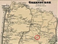
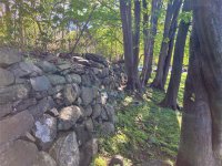
Using period maps I was able to access at our County Library here in White Plains, I was able to nail down the location of what is left of a stone wall, erected after the tavern was torn down, in 1801. The wall borders the area of the old Tavern by around 30-feet as far as I can put together. It also borders another road that led to the Hudson River, Irvington, and Tarrytown.

This is very near the parking lot of a very large shopping area in modern day Greenburg, on its very busy and commercial, Central Avenue. I invested some time getting to know the grounds keeping crew that takes care of the area, by getting them some doughnuts and coffee. I explained what I was researching, and what I was looking for. The supervisor thought it was cool and gave me permission to prospect along the fence.

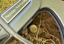
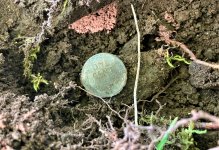
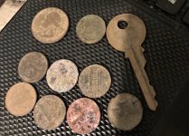
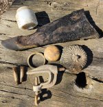
Well, I spent about an hour there this afternoon, I got about 30-feet of the rock wall and its base detected in that time. I was using Field M1, straight factory defaults. While visions of Colonial Coppers danced in my head, modern clad, a key, and a 194? Wheat penny was all I came up with. Incredible amounts of bottle caps, pull tabs, and screw tops, but the Legend is really helping me to sort out a lot of the trash targets.

I’ll be working this site for as long as I can. With the history in this area, there must be some history in this dirt. The home that Major John Andre, stopped at before he was captured and Identified as a British spy, is less than ½-mile from this location. I let you know when I hit paydirt – Wish me luck!
a.jpg a1.jpg b.jpg c.jpg d.jpg e.jpg f.jpg g.jpg h.jpg
 

Upvote 6

Digger RJ

Gold Member
Aug 24, 2017
19,481
33,600
SW Missouri/Oklahoma
🥇 Banner finds
1
🏆 Honorable Mentions:
2
Detector(s) used
Minelab CTX 3030; Minelab Equinox 800;
XP Deus 2
Primary Interest:
All Treasure Hunting
I have about 110-hours into researching a Colonial tavern in Greenburgh, New York, that was located along “Mile Square Road”- which was used heavily by both American, and British troops during the Revolutionary War. The tavern was owned by John Dusenbury, a “Loyalist,” who had a farm and estate in neighboring White Plains.

Using period maps I was able to access at our County Library here in White Plains, I was able to nail down the location of what is left of a stone wall, erected after the tavern was torn down, in 1801. The wall borders the area of the old Tavern by around 30-feet as far as I can put together. It also borders another road that led to the Hudson River, Irvington, and Tarrytown.

This is very near the parking lot of a very large shopping area in modern day Greenburg, on its very busy and commercial, Central Avenue. I invested some time getting to know the grounds keeping crew that takes care of the area, by getting them some doughnuts and coffee. I explained what I was researching, and what I was looking for. The supervisor thought it was cool and gave me permission to prospect along the fence.

Well, I spent about an hour there this afternoon, I got about 30-feet of the rock wall and its base detected in that time. I was using Field M1, straight factory defaults. While visions of Colonial Coppers danced in my head, modern clad, a key, and a 194? Wheat penny was all I came up with. Incredible amounts of bottle caps, pull tabs, and screw tops, but the Legend is really helping me to sort out a lot of the trash targets.

I’ll be working this site for as long as I can. With the history in this area, there must be some history in this dirt. The home that Major John Andre, stopped at before he was captured and Identified as a British spy, is less than ½-mile from this location. I let you know when I hit paydirt – Wish me luck!
View attachment 2026048 View attachment 2026049 View attachment 2026050 View attachment 2026051 View attachment 2026052 View attachment 2026053 View attachment 2026054 View attachment 2026055 View attachment 2026056
Nice!!! Congrats!!!
 

Jose The Goon

Hero Member
Apr 1, 2017
567
1,502
East Coast
Detector(s) used
Whites 6000D, 6000Di, Eagle, & PI 1000
Primary Interest:
Metal Detecting
Yeah, good luck to you Terry. Seems like a very promising spot. Hope your diligent research pays off big time. Too bad about all the modern trash.
The major bane of all us detectorists. I wish people weren't such litterbugs back in the day. We should all kiss the feet of the guy that invented the pull tabs that stay on the can.:laughing7:
p.s. Love the old photos, sign & map !!
 

Florida Finder

Bronze Member
Dec 17, 2020
1,718
5,321
Southern States of America
🥇 Banner finds
1
Detector(s) used
AT Max
Primary Interest:
Relic Hunting
I have about 110-hours into researching a Colonial tavern in Greenburgh, New York, that was located along “Mile Square Road”- which was used heavily by both American, and British troops during the Revolutionary War. The tavern was owned by John Dusenbury, a “Loyalist,” who had a farm and estate in neighboring White Plains.

Using period maps I was able to access at our County Library here in White Plains, I was able to nail down the location of what is left of a stone wall, erected after the tavern was torn down, in 1801. The wall borders the area of the old Tavern by around 30-feet as far as I can put together. It also borders another road that led to the Hudson River, Irvington, and Tarrytown.

This is very near the parking lot of a very large shopping area in modern day Greenburg, on its very busy and commercial, Central Avenue. I invested some time getting to know the grounds keeping crew that takes care of the area, by getting them some doughnuts and coffee. I explained what I was researching, and what I was looking for. The supervisor thought it was cool and gave me permission to prospect along the fence.

Well, I spent about an hour there this afternoon, I got about 30-feet of the rock wall and its base detected in that time. I was using Field M1, straight factory defaults. While visions of Colonial Coppers danced in my head, modern clad, a key, and a 194? Wheat penny was all I came up with. Incredible amounts of bottle caps, pull tabs, and screw tops, but the Legend is really helping me to sort out a lot of the trash targets.

I’ll be working this site for as long as I can. With the history in this area, there must be some history in this dirt. The home that Major John Andre, stopped at before he was captured and Identified as a British spy, is less than ½-mile from this location. I let you know when I hit paydirt – Wish me luck!
View attachment 2026048 View attachment 2026049 View attachment 2026050 View attachment 2026051 View attachment 2026052 View attachment 2026053 View attachment 2026054 View attachment 2026055 View attachment 2026056
So much history there Terry. Can wait to see all your future goodies that come out of there. Congratulations
 

Hunk-a-lead

Bronze Member
Dec 20, 2020
2,124
3,307
Kansas City
Detector(s) used
Nokta Legend, Predator Phoenix Shovel
Primary Interest:
Metal Detecting
I have about 110-hours into researching a Colonial tavern in Greenburgh, New York, that was located along “Mile Square Road”- which was used heavily by both American, and British troops during the Revolutionary War. The tavern was owned by John Dusenbury, a “Loyalist,” who had a farm and estate in neighboring White Plains.

Using period maps I was able to access at our County Library here in White Plains, I was able to nail down the location of what is left of a stone wall, erected after the tavern was torn down, in 1801. The wall borders the area of the old Tavern by around 30-feet as far as I can put together. It also borders another road that led to the Hudson River, Irvington, and Tarrytown.

This is very near the parking lot of a very large shopping area in modern day Greenburg, on its very busy and commercial, Central Avenue. I invested some time getting to know the grounds keeping crew that takes care of the area, by getting them some doughnuts and coffee. I explained what I was researching, and what I was looking for. The supervisor thought it was cool and gave me permission to prospect along the fence.

Well, I spent about an hour there this afternoon, I got about 30-feet of the rock wall and its base detected in that time. I was using Field M1, straight factory defaults. While visions of Colonial Coppers danced in my head, modern clad, a key, and a 194? Wheat penny was all I came up with. Incredible amounts of bottle caps, pull tabs, and screw tops, but the Legend is really helping me to sort out a lot of the trash targets.

I’ll be working this site for as long as I can. With the history in this area, there must be some history in this dirt. The home that Major John Andre, stopped at before he was captured and Identified as a British spy, is less than ½-mile from this location. I let you know when I hit paydirt – Wish me luck!
View attachment 2026048 View attachment 2026049 View attachment 2026050 View attachment 2026051 View attachment 2026052 View attachment 2026053 View attachment 2026054 View attachment 2026055 View attachment 2026056
bueno suerte!!
 

Top Member Reactions

Users who are viewing this thread

Top