Swift treasure markers? Let me know what you think

Joragi2

Newbie
Nov 24, 2021
2
4
Kentucky
Primary Interest:
All Treasure Hunting
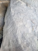
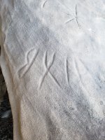
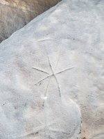
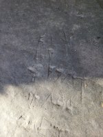
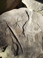
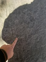
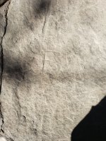
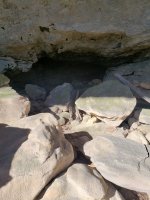
I have found these carvings preserved under a rock shelter, near a huge arch and light house arch, very close to a creek that "sinks" into the ground, not too far from a MASSIVE cave named after a man named Townsend, also not far from an unbelievable deep gorge with sheer cliffs, and within a mile of a large stone furnace. I also have what I believe is a very "peculiar" rock on the same ridge as a rock that juts out that could very easily be a "look out" rock; Buffalo lying down I'm not so sure. In between these carvings and the large arch is a big gap considering the area. 3 large tributaries are attributed to the area as the one in said gap the become the south fork then filing the Red river. When I found it in my youth I was looking for what I had been told were "Indian paintings" later to be informed that they were believed to be white man made or possibly french/ Indian times. It wasn't until my last visit last year I laughed about them being a clue to the Swift legend. This past year I began to read more about locations and landmarks of Swift lore. In my mind it was easy to connect these dots as any treasure hunter could do with an artifact such as this and a little imagination. I am relying on you Swift researchers to help me form an opinion as to what these carving might be. Could this be a compass of some kind a waybill or perhaps coded "turkey tracks"? If these images upload successfully I can add more pictures of the arch, look out rock, and peculiar rock so that your imaginations may run as wild as mine has. Thank you for allowing me into your group I can't wait to see what you think!
 

Attachments

  • 20201116_111205.jpg
    20201116_111205.jpg
    2.7 MB · Views: 99
  • 20201116_111219.jpg
    20201116_111219.jpg
    2.7 MB · Views: 99
  • 20201116_111234.jpg
    20201116_111234.jpg
    2.5 MB · Views: 100
  • 20201116_111302.jpg
    20201116_111302.jpg
    3.5 MB · Views: 103
  • 20201116_111352.jpg
    20201116_111352.jpg
    3.7 MB · Views: 88
  • 20201116_111421.jpg
    20201116_111421.jpg
    3 MB · Views: 99
  • 20201116_111426.jpg
    20201116_111426.jpg
    2.2 MB · Views: 94
  • 20201116_111554.jpg
    20201116_111554.jpg
    2.1 MB · Views: 94
  • 20201116_111557.jpg
    20201116_111557.jpg
    3.8 MB · Views: 97
  • 20201116_111630.jpg
    20201116_111630.jpg
    1.6 MB · Views: 104

KY Hiker

Bronze Member
Oct 28, 2014
1,537
3,220
North Central Kentucky
Detector(s) used
Whites
Primary Interest:
All Treasure Hunting
The 4th picture looks like possible indian carvings that have been carved over and partially destroyed. Symbols that resemble /\/\/\ or \/\/\/ have been posted on here before. I did some limited research and those symbols could mean camp or safe place. The square holes in rock look like where beams or posts would be placed to secure them for the building of a structure. That could be for the rockhouse to be used as a temporary home or stable for early settlers or more recent moonshine...very much impossible to date rock carvings. Generally the sharper the cuts the more recently they were done. Sandstone carvings generally grow over time so letter will get broader, its the action of moisture and freeze thaw cycles over time. PM me some more as to a rough location, I frequent the Red RIver Gorge area since I was a teenager in the 1980s. There are many creeks I could show you where they go underground and resemble 'drying ground'. Many of the creeks have parallel shallow cave systems under them, some have collapsed. Very interesting area you have, any dated carvings or JoS carvings would be further evidence it could be an area worked as they had several locations for mines. Not sure what your pointing at in the two pictures before the cave opening...I am using a laptop with a small screen.
 

Last edited:

KY Hiker

Bronze Member
Oct 28, 2014
1,537
3,220
North Central Kentucky
Detector(s) used
Whites
Primary Interest:
All Treasure Hunting
Crickets... I guess I am the only one looking at your pictures! The first two look like J X I A. Still cannot tell what your pointing at after the F.
 

franklin

Gold Member
Jun 1, 2012
5,036
7,168
Detector(s) used
Garrett ADS-7X, Fisher Two Box M-Scope, Mother Lode Locator, Dowsing Model 20 Electroscope, White's TM808, White's TM900, Inground Scanners
Primary Interest:
All Treasure Hunting
KY Hiker & Joragi2, I have looked at the photos also. They look like Old Welsh Symbols most likely Coelbren. The last symbol is a Broad Arrow sometimes point directions but most of the time it represents God. I do not know what the backwards letter (the first letter ) is or it's meaning. The other is the "X" meaning location and the Broad Arrow is pointing at a 7 pointed Star or symbol which could stand for how far to travel as you have another with 10 points. That would be a swell area to look around for mines of the Welsh as they mined gold and silver and stashed it near there also. The Melungeons were Welsh also. I know most claim they were Portuguese. But I prefer Welsh. The Square holes could have been used to grind salt petter to make gunpowder?
 

Curtis

Hero Member
Sep 3, 2008
899
1,009
Cincinnati
Primary Interest:
All Treasure Hunting
On Caney Creek near Grayson (backed up creek from the reservoir) ...has a rock shelter with those same square holes...talked to Mason or someone who said their uncle used the square holes for beams to hold up a wall at the front..turned the rock house into a barn! There are also similar rock carvings...and a mile up stream is the head shown in my avatar. Hmmm...wonder if the same people lived near your discovery. Did you find a balanced rock?..Swift mentions that too.
 

OP
OP
Joragi2

Joragi2

Newbie
Nov 24, 2021
2
4
Kentucky
Primary Interest:
All Treasure Hunting
On Caney Creek near Grayson (backed up creek from the reservoir) ...has a rock shelter with those same square holes...talked to Mason or someone who said their uncle used the square holes for beams to hold up a wall at the front..turned the rock house into a barn! There are also similar rock carvings...and a mile up stream is the head shown in my avatar. Hmmm...wonder if the same people lived near your discovery. Did you find a balanced rock?..Swift mentions that too.
No balanced rock that I know of, but a rock bridge, a look out rock, a sinking creek, a large low gap, furnaces, sometimes a waterfall, steep gorge walls, several small caves, and one large cave with the same name as the widow woman that swift may have given a journal to. And to boot these carvings are on the second level of an enormous rock house with about 5 other initials on it with another cave in it I have yet to explore. I feel like I'm close!!
 

GoDeep

Bronze Member
Nov 12, 2016
2,120
4,515
Detector(s) used
Whites, Garrett, Minelab
Primary Interest:
All Treasure Hunting
Marks, yes. Treasure marks, unlikely.
 

Top Member Reactions

Users who are viewing this thread

Top