The lost Dutchman’s gold mine location

Ramiro valdez

Full Member
Aug 26, 2020
182
103
San Antonio, Texas
Primary Interest:
All Treasure Hunting
The lost Dutchman’s gold mine location


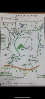
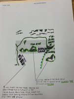
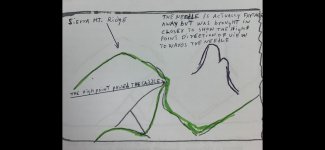
Around mid 1840’s the peralta family managed to locate a legendary gold mine belonging to the Apache with the help of a symbolic cipher map that was found inscribed in a stone. The mine was located in Apache territory east of the Sierra Ancha Mountain ridge. The Apache guarded the mine during the summer months and would only spy on the mine once in a while during the winter months. Those who found the mine could only work the mine in small numbers without been seen by the Apache during the winter months. This stone map probably belonged to a group of four other symbolic cipher stone maps that were found in the mid 1900’s. The stones were intentionally set along the side of a very common trail that led towards Phoenix, so they could be found. The stones carried a cipher message that could only be read by someone who was associated with the person who created the stones because it contained the whereabouts of rich gold mine location. The creator of the stones had to be very familiar with the area and the mine in order to have drawn all the details found on the stone cipher maps. Many doubt that these stones are more than two hundred years old. I believe that they were made around the year 1820. The Peralta’s family discovered the first stone with the cipher map thinking that the mine was near the place the stone was discovered. I believe that they could not read the map and had to rely on an Indian that probably let them to the mine. There is no way that I could decipher the stone maps without the help of a satellite, so I believe an Indian helped them find the location of the mine in Apache territory. No one could gain legal claim to this gold mine even if they said they claim it, because the Apache would never let you claim it. The Peralta family could not claim it, Jacob Waltz could not claim it, and there was also a man named Beal who claimed to have work the mine. The first cipher stone carried the word pine, north, salt lake, and the abbreviation of HOSS which most likely stands for hills on south side. These stones were probably created by an American who new how to creat symbolic cipher maps. These stones are soon going to be decipher exposing information that relates to Virginia which will tie into Beal’s legendary story defining him as the creator of the symbolic cipher stones which are currently called the Peralta Stones? And why not? If Beal could creat three cipher letters, then I see no problem with him ciphering stones? Someone like the museum in Arizona should start thinking about changing the name because it is not going to be long before someone finds out that the stones do not belong to the Peralta family. The Peralta’s, are recorded as the primary finders but not the actual makers of the stones. This legendary Apache gold mine will never be found west of the military trail nor in the superstitious mountains because it lies east on the east side of the Sierra Ancha Mountain ridge in a place called the Rock Horse. I have said that I can unfold the Nazi Lue map and that I can also lead you to Olivier Levasseur’s treasure. I can do this things because I know and I don’t think some of you understand what I’m saying so I’m going to make a point by describing some of Waltz cipher maps which are going to the location of the LDM. The most important cipher map has always been the map that Waltz gave to Julia Thomas. I call this map the map within a map because there are two maps stack one on top of each other. I have detailed the map and added more clues to more clearly define the actual location so it could be understood. The stone map carries a primary map surrounded by large iconic rock structures which I colored in purple. These structures were to be use to guide you in the right direction towards a place called the Rock Horse which was located towards the east Sierra Ancha mountain ridge. This map also carries starting instructions which are colored in yellow. The secondary map is a 9 square mile map which details the surrounding area of the Rock Horse which is colored in green. All you have to do is venture into the location and you will find all the details found on the secondary map which will lead you to to the gold mine located in the mouth of Rock Horse canyon. Note the face of the hidden canyon because you will see it also inscribed in two of the four other stone maps. You know, you might not get a lot of written credit here on this site for what you discover or find but what I like the most about treasurenet is the satisfying exposure of what someone says or finds which satisfies my needs in treasure hunting.
 

Attachments

  • 6D219A9C-39D3-4E5D-AE25-0D1136C88222.png
    6D219A9C-39D3-4E5D-AE25-0D1136C88222.png
    536.7 KB · Views: 613
  • 13783832-EC5B-4CD9-A972-1A5C123D1609.jpeg
    13783832-EC5B-4CD9-A972-1A5C123D1609.jpeg
    1.1 MB · Views: 597
  • FD697479-86A0-42CD-B087-5B351F73AE3C.jpeg
    FD697479-86A0-42CD-B087-5B351F73AE3C.jpeg
    118.9 KB · Views: 593
Last edited:

gollum

Gold Member
Jan 2, 2006
6,729
7,594
Arizona Vagrant
Detector(s) used
Minelab SD2200D (Modded)/ Whites GMT 24k / Fisher FX-3 / Fisher Gold Bug II / Fisher Gemini / Schiebel MIMID / Falcon MD-20
Primary Interest:
All Treasure Hunting
You write all this with a certainty. While we know a lot about the man and much around him (Jacob Waltz), very little is known about his mine. When you think you know something specific, you should REALLY beat feet out 40 miles East of Phoenix and verify your THEORY before writing in a manner like you actually know something, otherwise, you are just another one of the hundreds of people who post the same kind of crap over and over. Now don't get me wrong, your THEORY is just as good as everyone else's until some one shows actual proof of finding the LDM, but its just a theory without proof.

The Peraltas had their mines long before 1840. While we do know that the only authentic Peralta Spanish Land Grant was in Northern California. A Peralta owned about half of what is now San Francisco. This part of the Peralta Family went North from Mexico with Capt. Juan Antonio DeAnza in 1776. Waltz' Mine has been under several feet of dirt, rock, and ironwood logs since about 1880, by his own admission.

For some very specific reasons, I do not believe that the Old Silver Chief Mine in Rogers Canyon was the LDM (as rich as it was).

Mike
 

OP
OP
R

Ramiro valdez

Full Member
Aug 26, 2020
182
103
San Antonio, Texas
Primary Interest:
All Treasure Hunting
Here is another good theory of a map to look for less than 16 miles away from the salt river nail creek area and is not 40 miles away. When you go north and start climbing the Sierra Ancha mountain ridge look for the open square with the two drop down corners as inscribed in the middle of the map below. You will not be able to find two separate climbing ridges facing a northerly direction as indicated by the compass, anywhere in the surrounding area or the superstitious mountains except in the Sierra Ancha Mountain ridge. But, then again I might be wrong? The map below might just be another theory someone made up? No! Now I know! I believe in this map and believe this is a dam good theory!


C5DB9212-82D9-45FC-BC19-F42CF2390BA5.png
 

OP
OP
R

Ramiro valdez

Full Member
Aug 26, 2020
182
103
San Antonio, Texas
Primary Interest:
All Treasure Hunting
Here is another good theory of a map to look for less than 16 miles away from the salt river nail creek area and is not 40 miles away. When you go north and start climbing the Sierra Ancha mountain ridge look for the open square with the two drop down corners as inscribed in the middle of the map below. You will not be able to find two separate climbing ridges facing a northerly direction as indicated by the compass, anywhere in the surrounding area or the superstitious mountains except in the Sierra Ancha Mountain ridge. But, then again I might be wrong? The map below might just be another theory someone made up? No! Now I know! I believe in this map and believe this is a dam good theory!


View attachment 1988632


Let’s talk about the interesting map that you see above!


A Templar’s map! The art of cipher messaging! The idea is to find something important that you want no one to locate. In ciphering a map of location, you must first remove your self from the area on to a strategic place of elevation where someone can utilize the compass and plot the direction on a symbolic cipher map which will lead them on to the most secure path to the location. To use this specific map you must know the mountain range. This happens to be the Apache thunder god mountain located in the Sierra Ancha mountain range. The thunder god strikes many different places, but he dwells in the highest mountain range in the area. I’m pretty sure no Indian would agree that their god dwells on a lower mountain range. It’s base lies to the east because it’s higher than the the base that lies to the west in the salt river basin. The messaging describes you to position the compass found on the left side directly over the small cross. The compass will be moved towards the east and placed on the small cross. From that point the trail directs you to the east and the compass has only one pointer between the north and east that is pointing to the center of the general are of location. If you know how to read cipher maps then all you need to do is to locate the mountain range use your compass to direct you to the location. The magnetic field has changed over the years, so you will be off a little bit. That is not going to matter because the area your trying to find is quite large and not very far. One thing your going to learn about this lost legendary goldmine based on location is the true fact that the most safest way to approach the area is from the southwest. If you learn how to read symbolic cipher maps, stone maps, or cipher text, you will not be disappointed. Symbolic cipher map clues are meant to be use with a compass. The compass has to be adjusted with every major change. Locating a specific section on a map will require your first clue compass adjustment. When you enter a smaller section like mountain range there will be another adjustment. The immediate area will have the final adjustment. If your not sure where your going, you will walk right passed the goldmine and never know it. When you decipher a clue make sure that your bearing is straight or you end up somewhere in left field, as so many have done. This map is just one of many clues that are going to direct you to the proper location when it’s all set and done. If you want to learn more about symbolic cipher mapping, then stick around to learn more
 

Last edited:

crashbandicoot

Gold Member
Sep 27, 2020
12,131
27,107
Dumas,AR
Primary Interest:
All Treasure Hunting
Let’s talk about the interesting map that you see above!


A Templar’s map! The art of cipher messaging! The idea is to find something important that you want no one to locate. In ciphering a map of location, you must first remove your self from the area on to a strategic place of elevation where someone can utilize the compass and plot the direction on a symbolic cipher map which will lead them on to the most secure path to the location. To use this specific map you must know the mountain range. This happens to be the Apache thunder god mountain located in the Sierra Ancha mountain range. The thunder god strikes many different places, but he dwells in the highest mountain range in the area. I’m pretty sure no Indian would agree that their god dwells on a lower mountain range. It’s base lies to the east because it’s higher than the the base that lies to the west in the salt river basin. The messaging describes you to position the compass found on the left side directly over the small cross. The compass will be moved towards the east and placed on the small cross. From that point the trail directs you to the east and the compass has only one pointer between the north and east that is pointing to the center of the general are of location. If you know how to read cipher maps then all you need to do is to locate the mountain range use your compass to direct you to the location. The magnetic field has changed over the years, so you will be off a little bit. That is not going to matter because the area your trying to find is quite large and not very far. One thing your going to learn about this lost legendary goldmine based on location is the true fact that the most safest way to approach the area is from the southwest. If you learn how to read symbolic cipher maps, stone maps, or cipher text, you will not be disappointed. Symbolic cipher map clues are meant to be use with a compass. The compass has to be adjusted with every major change. Locating a specific section on a map will require your first clue compass adjustment. When you enter a smaller section like mountain range there will be another adjustment. The immediate area will have the final adjustment. If your not sure where your going, you will walk right passed the goldmine and never know it. When you decipher a clue make sure that your bearing is straight or you end up somewhere in left field, as so many have done. This map is just one of many clues that are going to direct you to the proper location when it’s all set and done. If you want to learn more about symbolic cipher mapping, then stick around to learn more
Very interesting,novel and intriguing.I enjoy reading this and articles like it very much.As I,ve said before it opens a window into a world I,ll likely never get to visit. To old and far away you see. Thank you so much.
 

Dirt1955

Full Member
Mar 10, 2015
190
363
Orange County, CA
Primary Interest:
All Treasure Hunting
Here is another good theory of a map to look for less than 16 miles away from the salt river nail creek area and is not 40 miles away. When you go north and start climbing the Sierra Ancha mountain ridge look for the open square with the two drop down corners as inscribed in the middle of the map below. You will not be able to find two separate climbing ridges facing a northerly direction as indicated by the compass, anywhere in the surrounding area or the superstitious mountains except in the Sierra Ancha Mountain ridge. But, then again I might be wrong? The map below might just be another theory someone made up? No! Now I know! I believe in this map and believe this is a dam good theory!


View attachment 1988632
Not saying the theory is wrong, I never discount the possibility...but this is a book of fiction, available for $6 dollars on Amazon.
 

OP
OP
R

Ramiro valdez

Full Member
Aug 26, 2020
182
103
San Antonio, Texas
Primary Interest:
All Treasure Hunting
The Dutchman also gave directions to the same place, but many did not understand where the military trail was, that led to north. A military trail was a trail that led from one fort to the other and is the same as a military road such as Military Dr., in San Antonio. Why? Was it called Military Dr.?Because it led one military base to another military base. In the old days you had to travel by the use of large historical iconic rock structures, telescope, and a compass. Fort Apache laid to the southeast of Fort McDowell. Since you could not fly over the Salt Lake River or the Sierra Ancha mountain range, many had to redirect themselves towards the south around the southern part of the Salt Lake River crossing. They then would backtrack towards the northwest along the Salt Lake River before going north towards Aztec Peak to gain elevation and proper direction towards Fort Apache. It was the best and safest rout they were willing to take. Once they reached elevation they would adjust their compass towards Fort Apache which was towards the southeast. At that turning point they could also elect to go to San Carlos, but that was not considered a military trail. The turning point was also considered to be part of the base belonging to the Apache Thunder God Mountain. There were not many military trials back then. The problem was that many were not familiar with the military routes in order to identify the clue Jacob Waltz left behind. Every clue left behind has to do with the Apache Thunder God mountain, like I said before. Sooner or later someone was going to find it, why not know? If you were my friend and wanted me to keep it a secret? Maybe I would have? Maybe? But at the moment every body is doing their own thing for me to even want to listen to them. So for those who wanted to know the location there it is and for those who are still not convinced, don’t worry I’m going to define each clue later on. Have a good weekend!!!!
 

OP
OP
R

Ramiro valdez

Full Member
Aug 26, 2020
182
103
San Antonio, Texas
Primary Interest:
All Treasure Hunting
The Dutchman also gave directions to the same place, but many did not understand where the military trail was, that led to north. A military trail was a trail that led from one fort to the other and is the same as a military road such as Military Dr., in San Antonio. Why? Was it called Military Dr.?Because it led one military base to another military base. In the old days you had to travel by the use of large historical iconic rock structures, telescope, and a compass. Fort Apache laid to the southeast of Fort McDowell. Since you could not fly over the Salt Lake River or the Sierra Ancha mountain range, many had to redirect themselves towards the south around the southern part of the Salt Lake River crossing. They then would backtrack towards the northwest along the Salt Lake River before going north towards Aztec Peak to gain elevation and proper direction towards Fort Apache. It was the best and safest rout they were willing to take. Once they reached elevation they would adjust their compass towards Fort Apache which was towards the southeast. At that turning point they could also elect to go to San Carlos, but that was not considered a military trail. The turning point was also considered to be part of the base belonging to the Apache Thunder God Mountain. There were not many military trials back then. The problem was that many were not familiar with the military routes in order to identify the clue Jacob Waltz left behind. Every clue left behind has to do with the Apache Thunder God mountain, like I said before. Sooner or later someone was going to find it, why not know? If you were my friend and wanted me to keep it a secret? Maybe I would have? Maybe? But at the moment every body is doing their own thing for me to even want to listen to them. So for those who wanted to know the location there it is and for those who are still not convinced, don’t worry I’m going to define each clue later on. Have a good weekend!!!!


Jacob Waltz left behind cipher clues, riddles, doodle maps containing hidden views, and an old symbolic cipher stone map that was supposed to help locate his hidden goldmine. He dived the information amongst some off his friends. He had the time to give someone proper directions to the goldmine without the use ciphering, but he probably saw that as a dangerous task for anyone of his friends to take on. He knew the risk would be too much for any of them by themselves. The alternative would be to not let them ever know or to dived clues amongst them so that each one had to depend on each other in order to find the hidden goldmine. It would also be less dangerous to travel in a group. The perfect plan was to elect a group of individuals that would not be greedy. But the honest truth is that greed is hard to detect and test, if you have no gold. They did not find the goldmine for several reasons. One they did not have symbolic deciphering knowledge. Two, they fail to work together as trusted friends. Three, they could not figure out what Waltz was talking about in reference to the clues or maps. After that they all started to wave the white flag which meant telling others that could possibly help in finding the mine. This is where miss information starts to grow causing confusion that allows the clues to loose some of their meaning. So don’t act or be confused, if you know what I’m talking about? Jacob Waltz made it clear that everything he left behind had to do with the goldmine and every piece of evidence is going to rely on each other to make this true! No doubt! So if you are not taking all the evidence serous, including miss information, into consideration then you will only be adding more confusion to the situation at hand. I’m not worried about those who want to add more confusion because I’m not confused. I’m the one that is going to be telling you, ( I told you so )? Because I’m going to teach and decipher the stone map. Something that should have been done in the very beginning. The stone map carries the information that leads you into the hidden canyon. So if you want to learn how to decipher the stone then stick around and wait for me. Soon!


The Dutchman also gave directions to the same place, but many did not understand where the military trail was, that led to north. A military trail was a trail that led from one fort to the other and is the same as a military road such as Military Dr., in San Antonio. Why? Was it called Military Dr.?Because it led one military base to another military base. In the old days you had to travel by the use of large historical iconic rock structures, telescope, and a compass. Fort Apache laid to the southeast of Fort McDowell. Since you could not fly over the Salt Lake River or the Sierra Ancha mountain range, many had to redirect themselves towards the south around the southern part of the Salt Lake River crossing. They then would backtrack towards the northwest along the Salt Lake River before going north towards Aztec Peak to gain elevation and proper direction towards Fort Apache. It was the best and safest rout they were willing to take. Once they reached elevation they would adjust their compass towards Fort Apache which was towards the southeast. At that turning point they could also elect to go to San Carlos, but that was not considered a military trail. The turning point was also considered to be part of the base belonging to the Apache Thunder God Mountain. There were not many military trials back then. The problem was that many were not familiar with the military routes in order to identify the clue Jacob Waltz left behind. Every clue left behind has to do with the Apache Thunder God mountain, like I said before. Sooner or later someone was going to find it, why not know? If you were my friend and wanted me to keep it a secret? Maybe I would have? Maybe? But at the moment every body is doing their own thing for me to even want to listen to them. So for those who wanted to know the location there it is and for those who are still not convinced, don’t worry I’m going to define each clue later on. Have a good weekend!!!!
 

Last edited:
OP
OP
R

Ramiro valdez

Full Member
Aug 26, 2020
182
103
San Antonio, Texas
Primary Interest:
All Treasure Hunting
Some people want to know more history behind the LDM. Some want to know how to decipher the stone map and others just want the gold. So the major audience is based on defining history of a stone map. So what we need to learn is symbols and their symbolic meanings. Informational map that direct you to a specific location are broken down into three sections or maps. The major map describes the perimeter of the field in play. The general map will describe a much smaller area usually within miles of the destination. The immediate map is much smaller and described the view of the designated place. To find the exact location in a canyon, house, building, or wall one will need added instructions in a form of another map or written instructions. The instructions will help you find what your looking for. They are normally memorized or ciphered in a text that you will only know and use when no one is following you. Three is a lucky number that you should always remember when trying to define where a map is taking you. So if you organized the three maps that Waltz drew for his friends, you will find that the first map points you in the direction of the gold mine or a ridge. The second map describes the ridge in question looking back at the needle with the use of a telescope. The third map describes the eye of the needle which looks to wards the high point on that ridge including the surrounding area around the hidden canyon. How else can someone get you to a destination without the use of the three most important things? The start, the middle and the end? A symbolic cipher map follows the same principle by using symbols. Navigating a map on land is similar to navigating a map in the ocean. You must adjust your direction every now and then by setting your compass to true north before laying it on the map to readjust your coordinates staying on track. You can not carry a large stone map with you, so the best thing to do is transcribe it onto a ledger. On a cipher map, you will find a miss aligned symbol that is supposed to be pointing true north. Aligning that symbol with the compass will allow you to slide the compass over to a designated symbol that points to the location acquiring the first coordinate or line of sight that your are going to need to stay on course. Finding a second directional symbol will be needed to plot the stopping point on that line of sight. Remember that the major map contains only large iconic structures or major rivers that can be use to plot your second coordinate. Those two coordinates will either intercept or intercept the general area in question? Your job? If you decided to take this 007! Is to find the coordinates on the stone map. Get a compass, find the transitional cross, align it, define pointing needle, plot the coordinate, seek and find the second symbol that directs you to the general area that is several square miles in diameter which will make it easy for you to define. Do not look for an exact location of the mine because your not there yet! The general area is big enough for you to define! Listen grass hopper! You must master the map in order to become the master! Or else I will have to do it for you which I probably will at a later time.
 

Dirt1955

Full Member
Mar 10, 2015
190
363
Orange County, CA
Primary Interest:
All Treasure Hunting
Ramiro, interesting theory. I'm a researcher and History buff. So my interests differ from others. As for the stone maps, any stone maps for that matter, my only interest is WHO carved them and WHEN were they carved. Without that basic information, everything regarding the stone maps is speculation. Please do continue though, I want to see where you are going with your theory.

Dirt
 

Terry Soloman

Gold Member
May 28, 2010
19,419
30,081
White Plains, New York
🥇 Banner finds
1
🏆 Honorable Mentions:
1
Detector(s) used
Nokta Makro Legend// Pulsedive// Minelab GPZ 7000// Vanquish 540// Minelab Pro Find 35// Dune Kraken Sandscoop// Grave Digger Tools Tombstone shovel & Sidekick digger// Bunk's Hermit Pick
Primary Interest:
Metal Detecting
Let me know when you want to know the REAL location. Probably should have used the flash.
nbn6.jpg
 

OP
OP
R

Ramiro valdez

Full Member
Aug 26, 2020
182
103
San Antonio, Texas
Primary Interest:
All Treasure Hunting
Ramiro, interesting theory. I'm a researcher and History buff. So my interests differ from others. As for the stone maps, any stone maps for that matter, my only interest is WHO carved them and WHEN were they carved. Without that basic information, everything regarding the stone maps is speculation. Please do continue though, I want to see where you are going with your theory.

Dirt


Thanks for the reply! Well, that’s understandable cause I’m also a history lover in general. I’ve studied Olivier Levasseur’s treasure map, the Nazi Lue map, Maximilian’s gold, the shallow rock pen treasure, the pirate Laffite, civil war lost gold stories, treasure island’s map, Otto Hillig’s coin treasure, Dutch Shultz, the lost French expedition, not much of Oak Island except a few little interesting details and a few other treasures to include a symbolic Templar’s historical symbolic cup describing history of Scotland in the late 1200’s. My methods include the history of the time period in question, the environment, the character of the pirate or individual, common sense and the application of knowledge attained from other similar individual or pirates. Because you are not born with knowledge, it is passed on to you by other ancestors through teachings or studies. The pirate learns what he can from another pirate then he adds his own spice to make it harder for you. If you can figure out one pirate you can possibly figure out another. Take for instance Otto Hillig’s treasure, he followed the same plan pattern describing the major area, triangulated the general area for you, and describes the immediate area as the witch and the number one. The spice here is not the three different map locations, the clues, or compass adjustment. This pirate learned how to fly in the early stages of flying. His spice was describing a view that he could describe from the sky because he flew passed the view lots of times. How can someone? Without a plane understand what he is looking at or for that matter define the clues. I’ll give you another example: a German who acquired the teaching of the Templar’s creates a map in his own image! No, not really! But you get the picture? He called it the Lue map! He added his own spice to the map! How can someone define his map? Well, that kind of a map can only be decipher by someone who knows symbolic meanings, compass directions, the hear say story that will need common sense, a plane, a major location for starting point and the knowledge of those who have hidden treasures before his time. Google earth has caught up to these pirates, so you don’t need a plane! LOL!!! The most important thing of all those spices, is the plane! Because he has to find the right place to buried the gold! The right entry point, the right hidden landing strip, most likely same location that someone else would have chosen because of the few locations that would accommodate the situation but only one that could hide the operation. Then there is the unavoidable truth of the symbolic information he has to use accordingly to define the area in question? Why? Because he is going to give you the view of the immediate area on the map as you would see it flying at low altitude over the location in question! You can take that to the bank! Why? Because I study all of these pirates! You happen to be a smart pirate! like me! Because no matter the story, true or not, there is always some truth in what people say? And you want to discover only the truth that will define the history in question. So, when you hear someone telling a story in a bar that concerns you, you must lean the ear, that’s a smart pirate! I will proceed to define the stones, just in case there happens to be truth in what I say that will help you define what your looking for! No problem! I was beginning slow down the story even more because I felt that the pirate’s were just drinking and not paying attention to the story. I find the cipher stone map so amazing! It describes every movement in detail! It’s like a book! It describes the reason why the stones were buried on the side of that specific trail! What I described above is not the detail portion of the stone map. It was just some of the information for those who don’t want to wait for the ending but have to work to find the gold, because for them there is no time to loose! Must crack on! I’m going to back track to the beginning to describe who I think had a hand in creating the stones maps by process of information early next week. Have a good treasure hunt weekend! Thanks! Again! For wanting know all that I know.
 

OP
OP
R

Ramiro valdez

Full Member
Aug 26, 2020
182
103
San Antonio, Texas
Primary Interest:
All Treasure Hunting
I’m sorry, Dirt 1955, I was just looking over everything I have done here on treasurenet.com. I had to jump all kinds of traps set by different groups to prove that I’m a worthy opponent. From someone saying I believe you, to I got your back, your the winner, to even bringing out the junior ranking person to set the trap before bringing out the backup to eliminate me like a great gladiator for entertainment purposes. I saw Jr coming a long ways out, calculate their patience which they could not avoid causing them to fall in their own trap by the use of information they left all over the net about their character. I saw the new guy coming a mile away wearing glass plus a lie written all over his forehead. Just because your coming from outside the net with a new assumed name doesn’t mean that some hasn’t already studied you. The talk behind the scenes are also very secretive that everyone can figure you out. You are, who you are, because, of who you hang around with? I’m not here for entertainment although it could help sometimes. I study everyone that cross me just to see if they are being truthful and! if not! the joke was on them. I warned you before that I was trained by pirates like Olivier L., Laffite, Shultz, The Two Otto’s, civil war thieves, and others like them who have increased my knowledge at play. It is an insult on to me every time these jokers get in the way of my teachings! If you know where the gold mine is located then post it! and then step aside! because it is not all about the gold! As, Dirt 1955, has mentioned! And his right! It will not be just about the name given to the stones? It will be about the lost history that needs to be found to help historians, including me, record the history! Plus find other treasures! Lol! So I’m going to try to forget the story about the Wizard Walt who gave special instructions to Dorthy Thomas, the Tin Man, Scarecrow and Todo the newspaper man. They followed the yellow brick road and found the ugly witch in Liberty New York. They were flying a plane cause Liberty is to plain? They suddenly saw the witch as they were flying towards the blue mountain ridge! Blankety! Blankety! Blankety! Blank! The blue ridge mountain cemetery looks over the golden coin! Yes? Flight plans have coordinates! No pressure! But they still found nothing!!! Dorthy and fans went over to the Wizard Of Ozland confronted the Wizard laughing at his plan? Waltz said, “ I knew it! Little grasshoppa! In the morning I’ll take you there? Wooho! Wooo! wooo! I’ll take you there! I’ll take you there! Wooo! Woo! Wooo! It’s a song if you didn’t get it? In the morning Waltz was dead as a doorbell? OMG! What do we do!! Sell the map and clues that leads to a nowhere plan? Good option plan!! Wait! Wait! Wait! Wooo! Why don’t we use it as a book cover like the book in treasure island where they used inside!!! Now here is the common sense about this! His was your friend! You like him for his gold! You were taking care of him cause he believed in you! And you!!!! Just called him lier! By your actions! So one night the spirit of Christmas pass comes back as Waltz the Wizard! He wakes up Dorthy and says, you were laughing at my instructions! Huh! I gave you!!! But I’m laughing at you! As a matter of fact all the great pirates are laughing with me! at you! Because people are laughing at you for not finding a thing! The joke is on you grasshopper! Think about it! Why would anybody give you a map and clues that your never going to use! And, no! The Lue map is not a cover of a rock group, it is a window puzzle made with symbolic ciphering that includes the view of the immediate area of one mile square in diameter! The same for all three treasures! The only exception is that Waltz could not use a plane even if he had one! Because his view can be seen by the ridge from the right side of the saddle because that is how you saddle this horse to see the view! As a matter of fact you don’t need the ridge because you have google earth that can clearly define the face of the hidden canyon! But if you! Position your self on that ridge physically! You can’t miss it! Because he left the view of the face of the canyon at the top of the stone map. By adjusting the head of the horse to the left on the map till it sits horizontally west to east you will be positioning the proper position of the face of the canyon as it will appear when the sun comes up. During the day the pointed nose may turn into an elephant nose! Who cares! The most important thing is that the map maker is giving you the clue of a view and you still don’t get it! Waltz was right! You will never find it even if it’s in front of your forehead because you don’t want to leave the west and travel to the east just a few more miles on a horse! The rat is only interested in the cheese! Stop staring at my writing this is not a written class! Your going to miss the point! It’s a lost history cipher clue map class! Sometimes I think it’s just about entertainment! So this is what I mean! You guys are driving me crazy! But now it’s all water under the bridge for me! But you got me!!! You all win!!!!!I’m confusing the community and must vacate the premises! This will be the second time you guys do this to me! I m going to go back to Disney World! Pop open a can of three X-X-X’s in reference to my accomplishments! From now on if I come back, I will only send Dirt1955 the symbolic meaning of the symbols that he can use to decipher the stone map! That way he can figure out the stone story book! There are five stone and each one attaches itself to each other to prove their connection to the story! And when you figure it out Dirt!!!! You can then apply reverse cipher engineering! To define all the symbols that you did not understand. The stone is a product made by a group of people. The producer of the idea takes control just like a block print? Because it takes several skill masters to put it together, but only one will take the responsibility of making sure everything gets done properly, which has nothing to do with the Peralta family other than it was found on their property! So be it!! keep the name loose the story!! fair trade! Keep me posted I’m clocking out!


——/-/-/-/-/-/-/-:::::::——————————————————

————lost heartbeat———dreaming of Disney World——
 

OP
OP
R

Ramiro valdez

Full Member
Aug 26, 2020
182
103
San Antonio, Texas
Primary Interest:
All Treasure Hunting
Hey! I’m just taking a break! I’m not leaving! I’m coming back to help he who game the thumb👍! It is hard to define what that means! Some use it as a good sign! Other use it as a bad sign! If I can figure out your character, I will know what that means! After all this is a symbolic cipher map class! When I come back I will write something specific for him for giving me the thumb! I’m going to describe my Latin heart to him and why I like it or why I chose it. In between I’m going to decipher little bits of the stone cipher map. But I need a Easter bunny break, I need some quite time for myself and family. I have other projects going on too! So I don’t know when I’ll be back! But I will, this isn’t oak island? You will discover the goldmine location and the the gold that was taken. Trust me. Good day
 

JackH

Full Member
Feb 26, 2011
211
19
Central Pennsylvania, ex SoCal
Detector(s) used
White's DFX
maybe I need this for therapy..,.....been a while climbing the side of the mountain with the most sand, not your mountain as most have been to THE mountain via my analogy..... and yet no one has proved mine wrong......
March 27,2011............ (https://www.treasurenet.com/threads/ldm-why-you-cant-get-it.223955/page-7)
Response: Most knowledgeable interested parties on this subject 'LDM' have spent considerable hours on the 'Peralta Stone's'. I have devoted some time on them as well, but never with any solid conclusions. This (Thread) has been a Progressive learning process. My feelings, are just feelings. I did not know if the Peralta Stone's were authentic until this posting. The relationship of Map #10's info (Map #60, a given) and finally connecting (my Theory) the Dots, do I Now believe that the 'Peralta Stones' are Real, my conclusions:

The deep line running across the bottom of the Heart Stone (mother rock) is the Salt. The Dagger (detailed, military like) is the road leading up towards the Ft Mc Dowell area. Knife part/arrow (upper guard, guardia urbano) look/start from the 4 Peaks below #1. The curved line leading from upside down (1) heads into the very center of the (Heart, symbol within symbol) below 4 Peaks, crack hiding 2nd peak, last peak extends outside heart. This is the same curved line as in Map #10 near 4 Peaks. Does the curved line mean (sound familiar) turn around 180 deg.'s 4 Peaks and look w s/w, to what the Heart Stone itself shows ? Bulls eye (small picacho, right end of trail string), "Turn around 180 deg.'s from 4 Peaks look w s/w for (small picacho, finger of God, Bulls eye, all in one, or just start here) followed by Oro symbol, 3 Red Hills (Red Mountain). The line leading away from the Bulls eye, a time table (a measurement) from 4 Peaks on horseback. Red Mountain is @ 23 miles from 4 Peaks. On horseback at @ 5 mph which I would think is a military caravan's speed, would take about 4 hours to get to other end (X), 3 Red Hills (Red Mountain). The 4 spaces between the dots on the line leading away from the Bulls eye would measure exactly that, to where the (X) is, foot of Red Mountain. As well as that line gives reference to starting well up the ridge line, below 1st of 4 Peaks.

If I placed wooden pegs into the solitary holes and attached a string connecting them, I get two out comes: 1) a dagger: connecting all pegs (reference to the Great Yavapai/Apache ?), 2) a cross: with the center of the upright from the cross, the center of the Heart Stone itself (1st. Catholic connection reason for being there, 2nd. center of all meaning, womb of Christianity).

The hole with the edge as if it was cut with a knife, pointing back to the (X) same as from the trail in center of Map #10, as coming in from the West.

With this explanation of the 'Heart Stone', two realities have surfaced: 1) Guardia Urbano, the 4 Peaks stand together, not in line behind each other. 2) Peak #1 is the closest to the Superstitions.

Definitively: If the curved arrow within the Heart Stone itself, is pointing at the 1st ridge below the 4 Peaks (#1, knife ref.) the angle from the ridge to Red Mountain is the same as the satellite image.

Lastly, this 'Heart' within Red Mountain is 475-500 ft high, and only under ideal conditions (shadows cast), time of day, year, can the whole Heart be seen......J

Good Luck with that, no one will take the time to write as much as you have unless you have caught the fever like those who have come before you..........
PERALTA HEART STONE enlarged.gif
 

Last edited:

Top Member Reactions

Users who are viewing this thread

Top