The mysterious death of Adolph Ruth

markmar

Silver Member
Oct 17, 2012
4,117
6,259
Primary Interest:
All Treasure Hunting
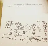
I was talking about this map
BW-18.jpg

In this map are mixed some clues which lead to treasure with the Perfil mapa. Mountain of Coronado, Eagle Head and King Royal ( fifth? ) are names which don't fit with what represent the Perfil mapa.
Had Adolph Ruth clues to Spanish treasure in the Superstitions? IMO he had. And I can explain why. From what I can see in the map, he knew about at least two treasure spots in the " Coronado " Mt., but I will write only about the Eagle Head place. Only the treasure at the Eagle Head landmark is close to the canyon floor, and I believe Ruth was looking for a Spanish sign/landmark which would show him he was close to the treasure. IMO, first he shoud find a pile of rocks about 39 feet/steps from the water in the canyon and then he should look up to see the rock which is a reproduction of the Eagle Head landmark. From that rock the mine is about 69 feet/steps away up on the mountainside and below the natural Eagle Head landmark.
I believe this spot was described also in the Richard Harmond map, and is the place which was found also by a group of treasure hunters in the 40's and by Ray Diamond few years later.
Here I have to say how the Eagle Head is only the half part ( the right side as you are looking from across the canyon ) of that mountain outcroping because the left half resembles a right side of a skull. I have read somewhere about a map which depicts a skull, and the description of the map made by the person who has seen it goes like this:
" The map as I remember it didn’t have any known landmarks on it except for a flat butte.Towards the center was a drawing of the left side of a skull lying on its back side, from the eye of the skull a scroll line encircled the eye to the right and then to the throat, at the base of the throat were many crosses, on the side of the skull to the right of the eye, written perpendicular was the word MINA.
Further left of the skull in a canyon and below the cliff of the flat butte was a dark spot, below the spot was written Geronimo cueva."
I post two aerial images to see the Skull and the Eagle Head landmarks, the sign/reproduction of the eagle head ( in the blue circle ) and the mine spot with yellow ( dot and circle ).

View attachment 1794527 Eagle sign.jpg
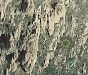
I know, I wrote Jesuit treasure, not because they produced that gold in the Eagle Head spot ( nor took something from there ) but because they found it and marked it with their mark, the Holy Cup. Is the mark which the guys who found it in the 40's described it like " a hourglass with one chamber upon the other ".
 

Last edited:

Gregory E. Davis

Sr. Member
Oct 22, 2013
332
999
Tempe, Arizona
Detector(s) used
eyeball it
Primary Interest:
All Treasure Hunting
Does anyone know the connection between Adolph Ruth and LV Ashfield year 1912?
Good evening Frank: Don't know his connection to Ruth but he was a Draftsman/Architect and living in Arizona 1913-1914 then moved to Spokane, Washington by 1917. Cordially, Gregory E. Davis
 

Gregory E. Davis

Sr. Member
Oct 22, 2013
332
999
Tempe, Arizona
Detector(s) used
eyeball it
Primary Interest:
All Treasure Hunting
Thanks Greg. Poncho said the same. He get that from you, he who knows all
Good evening Frank: If you want to do more research on L.V. Ashfield, His full name is Leroy Valentine Ashfield. Born October 10th. 1886 and died December 1th. 1958. His son Joseph (Joe) Leroy Ashfield was born June 2nd. or 3rd., 1913 in Maricopa County, Arizona. Cordially, Gregory E. Davis
 

Gregory E. Davis

Sr. Member
Oct 22, 2013
332
999
Tempe, Arizona
Detector(s) used
eyeball it
Primary Interest:
All Treasure Hunting
Good evening Frank: If you want to do more research on L.V. Ashfield, His full name is Leroy Valentine Ashfield. Born October 10th. 1886 and died December 1th. 1958. His son Joseph (Joe) Leroy Ashfield was born June 2nd. or 3rd., 1913 in Maricopa County, Arizona. Cordially, Gregory E. Davis
The correct date is June 3rd. 1913. Phoenix, Arizona. Cordially, Gregory E. Davis
 

gollum

Gold Member
Jan 2, 2006
6,729
7,594
Arizona Vagrant
Detector(s) used
Minelab SD2200D (Modded)/ Whites GMT 24k / Fisher FX-3 / Fisher Gold Bug II / Fisher Gemini / Schiebel MIMID / Falcon MD-20
Primary Interest:
All Treasure Hunting
Marius,

I think the event you are referring to was when Erwin and his father went to Anza-Borrego Desert in 1919 trying to locate the area of the third map (a Lost Gonzalez Mine). This was when Adolph fell into a gully in the dark, shattering his hip and leg. This earned him the silver plates, pins, and screws by which his body was identified.

Mike
 

gollum

Gold Member
Jan 2, 2006
6,729
7,594
Arizona Vagrant
Detector(s) used
Minelab SD2200D (Modded)/ Whites GMT 24k / Fisher FX-3 / Fisher Gold Bug II / Fisher Gemini / Schiebel MIMID / Falcon MD-20
Primary Interest:
All Treasure Hunting
Hey Frank,

You might have already seen this, but I found his grave:

Capture.JPG
 

detectorcowboy

Hero Member
Nov 30, 2009
535
830
Florida
Detector(s) used
XP Deus 2, Equinox 800, & Fisher CZ3D
What the hell gives any sheriff's offices the right to destroy any investigative reports
 

OP
OP
Matthew Roberts

Matthew Roberts

Bronze Member
Apr 27, 2013
1,131
4,955
Paradise Valley, Arizona
Primary Interest:
All Treasure Hunting
What the hell gives any sheriff's offices the right to destroy any investigative reports
The Maricooa County Sheriffs office has in its operational procedures, all inactive files will be purged after 70 years. The Adolph Ruth file was never a murder investigation file, it was always a missing person's investigation.
The Ruth file was purged in 2005, seventy three years after the 1932 investigation.
While Sheriff MacFadden had suspicion that Ruth may have been murdered, there never was enough hard evidence to open an official murder investigation.
 

markmar

Silver Member
Oct 17, 2012
4,117
6,259
Primary Interest:
All Treasure Hunting
Marius,

I think the event you are referring to was when Erwin and his father went to Anza-Borrego Desert in 1919 trying to locate the area of the third map (a Lost Gonzalez Mine). This was when Adolph fell into a gully in the dark, shattering his hip and leg. This earned him the silver plates, pins, and screws by which his body was identified.

Mike
Mike
I believe Adolph Ruth went in the Superstitions to locate two spots. One of a Peralta cache and another of a Peralta mine. For the cache had the Khiel map and for the mine had the Perfil mapa . Actually, the Willow Spring where Ruth had camped, was not that in the West Boulder Canyon, but the Laurel Spring from the Khiel map, which is at the end of the Peralta Trail in the East Boulder Canyon, few yards to the north.
Then , the Peralta Canyon was named Willow Canyon, so the trail was named Willow Canyon Trail and for this the spring at the end of the trail was known to the ranchers as Willow Spring.
How I came to the conclusion Ruth had the Khiel map? Dave ( azdave35 ) few years ago wrote he has seen the map that was stolen from Ruth and on it was written about a Laurel grove. The only map on the LDM collection that mentions on it a Laurel grove is the Khiel map. So, I decided to give a better look to this map, despite it's was written in English. And what i have found? It's a Peralta style coded map which use English words, thing which had not surprised me too much because I have seen a Peralta map before ( the ORO MAP 1915 ) in which they used both Spanish and English words. So, with the help of GE and using the codes on the Khiel map, I was able to find the spot of the cache. And then what i found again? The directions given on the map are exactly the dimensions of the edges of an open space in the brush around the spot, on which they marked also with rocks at few feet intervals. They chose to give a route along the edge of the open instead to write " Go from the stump 12 feet to the NE ".
 

Last edited:

HappyTrails55

Sr. Member
Sep 30, 2005
409
437
Paso Robles
Detector(s) used
Teknetics G2
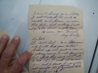
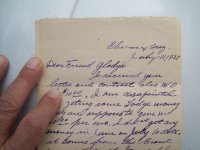
The 2nd addition of Jack San Felice Finding El Dorado is out. Includes photos of the lost Adolph Ruth maps that were found on his body. This book is a must read if you into the Ruth story.
[email protected]
View attachment 2100857 View attachment 2100858
Yeah, well good luck with that! If you all only knew the facts instead of the Legend, but Loose Lips Sinks Ships....I have the REAL MAP and I have been there quite recently (Jan., 2023) Darrell Lane
 

Attachments

  • 101_5218.JPG
    101_5218.JPG
    954.7 KB · Views: 73
  • 101_5217.JPG
    101_5217.JPG
    924.5 KB · Views: 72
  • 101_5214.JPG
    101_5214.JPG
    977 KB · Views: 75
  • 101_5198.JPG
    101_5198.JPG
    1,020.3 KB · Views: 72
OP
OP
Matthew Roberts

Matthew Roberts

Bronze Member
Apr 27, 2013
1,131
4,955
Paradise Valley, Arizona
Primary Interest:
All Treasure Hunting
20231019_142953.jpg

Maricopa County Sheriff's photograph.

Deputy Lon Jordan stands beside a white sheet thrown over a rock to orient search aircraft looking for lost prospector Adolph Ruth in the summer of 1931.
The Sheriff's photo is captioned, "Ruth's last camp" and the location is noted on the back.

The location noted is the northwest end of Peters Mesa. Personal items belonging to Adolph Ruth were found there along with a camp under Laurel trees about one hundred feet away.

The sheet over the rock is approximately 3-4 miles north of where Ruth's remains were later found on the northeast end of Black Top Mesa.
 

Last edited:

Clay Diggins

Silver Member
Nov 14, 2010
4,883
14,251
The Great Southwest
Primary Interest:
Prospecting
View attachment 2111041
Maricopa County Sheriff's photograph.

Deputy Lon Jordan stands beside a white sheet thrown over a rock to orient search aircraft looking for lost prospector Adolph Ruth in the summer of 1932.
The Sheriff's photo is captioned, "Ruth's last camp" and the location is noted on the back.

The location noted is the northwest end of Peters Mesa. Personal items belonging to Adolph Ruth were found there along with a camp under Laurel trees about one hundred feet away.

The sheet over the rock is approximately 3-4 miles north of where Ruth's remains were later found on the northeast end of Black Top Mesa.
Laurel trees in Arizona. ???
Did Ruth plant them there?
 

Top Member Reactions

Users who are viewing this thread

Top