The Sombrero Mine

OP
OP
A

ancientones

Full Member
Apr 16, 2010
102
105
This is where LaBarge turns and heads NW. I will show my estimation on his sketch map and his directions but
I have not verified this in the field. This is based off of GE and what I see.
There is a trail going straight N from LaBarge, and goes up a ridge. There is another trail to the left of this trail, a
rock pillar at this junction. There is a saddle on this long ridge, and at the end of the ridge 4 Peaks line up(N) and Weavers is South. Around the saddle area the trail goes down to enter the canyon to continue to the camp.
There are 'Mexican sign' on the hillside and a trail, this would match the sketch map if arrow is Peters. So mines on the 'West' side of Peters as well. I believe the straight and squiggly line and dot with arrow are pointing to the 'side' canyon East and its layout and mine-one of a few in this side canyon.
If his clue was 'It lies within a 5 mi circle of WN, Volcanic Peak, rock sticking up', his other clues will fit.
There is a 'large gold deposit' that runs 3 mi. along a ridge 'pushed up' exposing this on the Western
edges. The people finding and mining them(1846, 1847) had to leave, but they made sign/maps so future trips would know where to go-these were not 'tapped out'-they have value to come back to.
Is this the LDM? Which one? :)
View attachment 2073688
View attachment 2073689
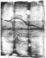
If one believes the massacre is true and the Apache buried the mines, would the Miners have time to carry anything out versus just leaving? If tools, ore found at the massacre site, yes. If no they would still be at the sites.
 

OP
OP
A

ancientones

Full Member
Apr 16, 2010
102
105
This is my estimate of the 'Heart' boundaries which this stone is advising. The mines will be in this heart. The green line is trail into the site, my tacks are showing est. location for these mines, from the 1846 sketch map.
1678719977484.png

The other heart inlay stones reflect add. info, the # of this mine for example. The other info could be ore mined to date or an estimate of what they think is in this hole-this I do not know.
1678723443481.png

GE on year 2010 seems best, but encourage you to go thru 2007 to current.
If you are standing on the Sombrero hill you can see much. This is a heart
that is still visible, with a mine symbol pointing to 2 mines. It looks like a clock showing 15 minutes to 5.
The arms are pointing to the mines-which are close by. You can see the trail go
to the rock outcropping they mined. At the outcropping you will find white rock on black rock,
black rock on white rock, 'markers'. They documented 'exactly' where the mines are.
The Heart means treasure is here, and this would be 'removed' once the hole has been cleaned out.
1678723248932.png

The Dutchman mine is a neat story/legend. I have a much bigger story and having to produce 'his' ore to be sampled to a sample on file, regardless of any other material provided, speaks volumes and misses the 'why'
he found gold here. The bigger story :)
 

markmar

Silver Member
Oct 17, 2012
4,117
6,259
Primary Interest:
All Treasure Hunting
If you look at the 1846 Mexican sketch map, this reflects 6 mines with 1 showing a Sombrero and
a mine on the 'West' side of the wash. This is a common symbol. I call this the Sombrero Mine based om the sketch map that led me here. I am sure the Mexican miners had a name for this mine-I have no interest in the name.
As for the mine, I could have taken samples out. These could have been tested and confirmed, and the net
result would be the same as 100 pics of all the clues. What good is gold brought out to provide proof for the location it was taken from and was it in accordance with the FS regulations? Human nature is many are interested in the gold and will do anything to obtain it, regardless of the Laws.
IMHO, the Peralta-Fish map shows a different region than Peter Canyon and Tortilla Creek.
You wrote the word " wash ", which you believe it's depicted on the map. There were never depicted washes or canyons in the Spanish/Mexican maps after 16th century. If you believe they did, then you are afar to can solve any of their maps. The only map in which I saw they used a mix of ravines and mountain tops, is the Espejo map dated 1588, made for the Uintas range in Utah.
 

OP
OP
A

ancientones

Full Member
Apr 16, 2010
102
105
IMHO, the Peralta-Fish map shows a different region than Peter Canyon and Tortilla Creek.
You wrote the word " wash ", which you believe it's depicted on the map. There were never depicted washes or canyons in the Spanish/Mexican maps after 16th century. If you believe they did, then you are afar to can solve any of their maps. The only map in which I saw they used a mix of ravines and mountain tops, is the Espejo map dated 1588, made for the Uintas range in Utah.
markmar,
You are correct, the maps do not reflect this I use Tortilla Creek/Wash and Peters Canyon so you can match the stone map 'lines' up. My apologies for calling it Tortilla Wash. The Salt is on top, then Mesquite, Tortilla, and Peters. These merge heading West towards the Salt. There is also a clue about 'the way to the mine can be found above the junction of a 'wash' coming from the East and a Narrow Canyon from the South'. I believe this was a Mexican clue. I located this following the story on Tom Kollenborn, he was following and mapped this Mexican trail, but 'lost' the trail on this hilltop. He shows it going N back down into Tortilla and then West, the trail goes down the East side of Tortilla and South. Fish Creek is not on this map but should be. There are other Peralta Stones I have not reviewed, the 'Horse' stone is interesting, but too much to see here.
These Mexican signs/symbols were not unique to the Sups. or the Peraltas so if you have other places
Good luck and Thank you for the post
 

markmar

Silver Member
Oct 17, 2012
4,117
6,259
Primary Interest:
All Treasure Hunting
markmar,
You are correct, the maps do not reflect this I use Tortilla Creek/Wash and Peters Canyon so you can match the stone map 'lines' up. My apologies for calling it Tortilla Wash. The Salt is on top, then Mesquite, Tortilla, and Peters. These merge heading West towards the Salt. There is also a clue about 'the way to the mine can be found above the junction of a 'wash' coming from the East and a Narrow Canyon from the South'. I believe this was a Mexican clue. I located this following the story on Tom Kollenborn, he was following and mapped this Mexican trail, but 'lost' the trail on this hilltop. He shows it going N back down into Tortilla and then West, the trail goes down the East side of Tortilla and South. Fish Creek is not on this map but should be. There are other Peralta Stones I have not reviewed, the 'Horse' stone is interesting, but too much to see here.
These Mexican signs/symbols were not unique to the Sups. or the Peraltas so if you have other places
Good luck and Thank you for the post
First, I want to mention to you and to the others who are reading this and are interested in the Superstitions lore and gold, the Peralta-Fish map has nothing to do with the stone maps. The Peralta-Fish map was made by a Peralta family member and the Stone maps were made by Jesuits.
The Peralta-Fish map covers a region of about 7x5=35 square miles ( if leave out the title and signature ) of the west Supestitions and the stone maps cover a region of about 280x265=74.200 square yards. So, you can imagine the dimension of the heart stone inlay and the Latin stone map which it's double in dimension than the inlay heart.
Good luck to you too. You need more than a miracle to find something in a place in which what are you searching for doesn't exist.
 

Last edited:

Doc4261

Hero Member
Nov 5, 2015
582
578
Primary Interest:
All Treasure Hunting
First, I want to mention to you and to the others who are reading this and are interested in the Superstitions lore and gold, the Peralta-Fish map has nothing to do with the stone maps. The Peralta-Fish map was made by a Peralta family member and the Stone maps were made by Jesuits.
The Peralta-Fish map covers a region of about 7x5=35 square miles ( if leave out the title and signature ) of the west Supestitions and the stone maps cover a region of about 280x265=74.200 square yards. So, you can imagine the dimension of the heart stone inlay and the Latin stone map which it's double in dimension than the inlay heart.
Good luck to you too. You need more than a miracle to find something in a place in which what are you searching for doesn't exist.
Markmar, the stone maps covers an area of bout 20 miles by 10 miles.
 

OP
OP
A

ancientones

Full Member
Apr 16, 2010
102
105
Markmar, the stone maps covers an area of bout 20 miles by 10 miles.
First, I want to mention to you and to the others who are reading this and are interested in the Superstitions lore and gold, the Peralta-Fish map has nothing to do with the stone maps. The Peralta-Fish map was made by a Peralta family member and the Stone maps were made by Jesuits.
The Peralta-Fish map covers a region of about 7x5=35 square miles ( if leave out the title and signature ) of the west Supestitions and the stone maps cover a region of about 280x265=74.200 square yards. So, you can imagine the dimension of the heart stone inlay and the Latin stone map which it's double in dimension than the inlay heart.
Good luck to you too. You need more than a miracle to find something in a place in which what are you searching for doesn't exist.
 

OP
OP
A

ancientones

Full Member
Apr 16, 2010
102
105
markmar,
I have no knowledge of a Peralta-Fish map and have never advised of one in my material. Fish creek is 1 mi. East of Tortilla and 'would' fit on this Peralta stone map, if it had any bearing. Who made the maps is not something I care about, I just want to know if the map is true. The Mexican miners had them and that is good enough for me. There
are other Peralta maps I have not spent any time on, my material is for the 2 map stones and the Heart inlay. Peters
Canyon(zig zag) and this mine are in this heart.
 

markmar

Silver Member
Oct 17, 2012
4,117
6,259
Primary Interest:
All Treasure Hunting
markmar,
I have no knowledge of a Peralta-Fish map and have never advised of one in my material. Fish creek is 1 mi. East of Tortilla and 'would' fit on this Peralta stone map, if it had any bearing. Who made the maps is not something I care about, I just want to know if the map is true. The Mexican miners had them and that is good enough for me. There
are other Peralta maps I have not spent any time on, my material is for the 2 map stones and the Heart inlay. Peters
Canyon(zig zag) and this mine are in this heart.
The 1846 sketch map which you used up side down in your first post of this thread, it's a bad reproduction of the Peralta-Fish map. You could do a research after i mentioned it, but you are too vested with your theory to look at anything else. Fish ( name ) added to the map it's not for Fish Creek, but for the person who brought the map to the public.
 

Attachments

  • Fish-Al.jpg
    Fish-Al.jpg
    88.3 KB · Views: 52
Last edited:

Clay Diggins

Silver Member
Nov 14, 2010
4,883
14,251
The Great Southwest
Primary Interest:
Prospecting
The Peralta-Fish map was made by a Peralta family member and the Stone maps were made by Jesuits.
It sure would be nice if you provided your verifiable sources for these two statements Marius.

I have found zero evidence that any of the many Peralta families in the southwest ever produced a treasure map.

The so called stone maps have zero history before their miraculous "discovery" on the side of the highway. Jesuits? Really?

It seems many of your theories are based on your belief in the origination of these "maps". I'm all good with you having any theories or beliefs you wish, it's a free country. I do have a problem with how you constantly try to correct anyone with a different theory or belief. Until you, or someone else, actually produces a gold mine with actual gold ore it's all just theory and belief.

Here's my belief - if you just relax and enjoy the myriad of ideas that flow through this, and other, forums you might actually learn something. Or not - the choice, as always, is yours. :thumbsup:
 

Last edited:

Doc4261

Hero Member
Nov 5, 2015
582
578
Primary Interest:
All Treasure Hunting
It sure would be nice if you provided your verifiable sources for these two statements Marius.

I have found zero evidence that any of the many Peralta families in the southwest ever produced a treasure map.

The so called stone maps have zero history before their miraculous "discovery" on the side of the highway. Jesuits? Really?

It seems many of your theories are based on your belief in the origination of these "maps". I'm all good with you having any theories or beliefs you wish, it's s free country. I do have a problem with how you constantly try to correct anyone with a different theory or belief. Until you, or someone else, actually produces a gold mine with actual gold ore it's all just theory and belief.

Here's my belief - if you just relax and enjoy the myriad of ideas that flow through this, and other, forums you might actually learn something. Or not - the choice, as always, is yours. :thumbsup:
He's not the only one with the belief the stone maps are Jesuit. I too hold that belief. For multiple reasons. The size of area it covers would of took alot of knowledge and expertise in map making. Also the writing on them. Tho the Peraltas probably stumbled upon them in their travels into the Sups.
 

markmar

Silver Member
Oct 17, 2012
4,117
6,259
Primary Interest:
All Treasure Hunting
It sure would be nice if you provided your verifiable sources for these two statements Marius.

I have found zero evidence that any of the many Peralta families in the southwest ever produced a treasure map.

The so called stone maps have zero history before their miraculous "discovery" on the side of the highway. Jesuits? Really?

It seems many of your theories are based on your belief in the origination of these "maps". I'm all good with you having any theories or beliefs you wish, it's s free country. I do have a problem with how you constantly try to correct anyone with a different theory or belief. Until you, or someone else, actually produces a gold mine with actual gold ore it's all just theory and belief.

Here's my belief - if you just relax and enjoy the myriad of ideas that flow through this, and other, forums you might actually learn something. Or not - the choice, as always, is yours. :thumbsup:
Ok, I'm relaxing now. It took me many years to understand the concept behind the Spanish-Mexican-Jesuit maps. There are almost the same, using the same coded symbols, but every map which belongs to a specific family, tend to use the same patron for every map they made. It's like a fingerprint which belongs to unique persons.
I can produce many gold mines if I want, in the Superstitions or somewhere else, but this could be only in my own beliefs.
You are right, i should not correct anyone if they are wrong in regards to my beliefs, the dreams are for free, even if the dreams are not reality. Like you tried to teach us, the reality matters and not what everybody say and write.
 

Last edited:

Matthew Roberts

Bronze Member
Apr 27, 2013
1,131
4,955
Paradise Valley, Arizona
Primary Interest:
All Treasure Hunting
I have no definite belief one way or another in the Peralta Fish map or the Stone Maps but do know something of their origin.

Frank Fish received his map from the family of Peralta descendants in Mexico. The map history is published in Erie Schafers book, Dead Men Tell No Tales. Frank Fish gave his account directly to Schafer and after Fish's death Schafer obtained the map.

Francisco (Frank Peralta) of Riverside California was a member of the family that gave Fish the map and partnered with the Schafer's and several others in a search of the Superstitions in the 1960's using the Peralta-Fish nap.

The Stone Maps have a dozen stories of how they came to be, the Jesuits being just one of them.

Many claim to know exactly when they were made and by who. Many claim to have their "evidence" as proof however no one has proved their so called "evidence".

The Stone Maps remain a question and everyone has a right to their theory, real or fake until proven otherwise.
 

Clay Diggins

Silver Member
Nov 14, 2010
4,883
14,251
The Great Southwest
Primary Interest:
Prospecting
He's not the only one with the belief the stone maps are Jesuit. I too hold that belief. For multiple reasons. The size of area it covers would of took alot of knowledge and expertise in map making. Also the writing on them. Tho the Peraltas probably stumbled upon them in their travels into the Sups.
I'm not criticizing the belief you, and others, hold. Believe what you wish. I was criticizing Marius' habit of writing other posters are wrong when they come to different conclusions or beliefs than he does. It's not conducive to open discussion and it stifles those who are trying to discover the verifiable facts.

As far as knowledge and expertise in map making, I am a cartographer - the stones are childish representations even by medieval standards. For their time period, whether you go by their 1940 ish discovery date, the Jesuit period or some imaginary Peralta family they are obviously not created by an actual accomplished cartographer.

Knowing and having worked with Ted I suspect the stones were made by him or one of his friends. Just my take on the facts as known. Not a belief.
 

Doc4261

Hero Member
Nov 5, 2015
582
578
Primary Interest:
All Treasure Hunting
I'm not criticizing the belief you, and others, hold. Believe what you wish. I was criticizing Marius' habit of writing other posters are wrong when they come to different conclusions or beliefs than he does. It's not conducive to open discussion and it stifles those who are trying to discover the verifiable facts.

As far as knowledge and expertise in map making, I am a cartographer - the stones are childish representations even by medieval standards. For their time period, whether you go by their 1940 ish discovery date, the Jesuit period or some imaginary Peralta family they are obviously not created by an actual accomplished cartographer.

Knowing and having worked with Ted I suspect the stones were made by him or one of his friends. Just my take on the facts as known. Not a belief.
You say the stones are childish, but the areas depicted are exactly what is represented . One doesnt have to imagine anything. The one's that made them had extensive knowledge of the Sups and also above the salt river. They weren't made by the supposed finder. I'm not ready to show the h/p area yet or I'd bet you would change your tune. To each their own.
 

OP
OP
A

ancientones

Full Member
Apr 16, 2010
102
105
He's not the only one with the belief the stone maps are Jesuit. I too hold that belief. For multiple reasons. The size of area it covers would of took alot of knowledge and expertise in map making. Also the writing on them. Tho the Peraltas probably stumbled upon them in their travels into the Sups.

You say the stones are childish, but the areas depicted are exactly what is represented . One doesnt have to imagine anything. The one's that made them had extensive knowledge of the Sups and also above the salt river. They weren't made by the supposed finder. I'm not ready to show the h/p area yet or I'd bet you would change your tune. To each their own.
I agree Doc4261,
The Mexicans were taught by the Spanish who were 'excellent' map makers, the best in history per some.
The Spanish mined the Sups way back when, and due to Apache or whatever, they did not find it all. After the Mexican revolution, the Mexicans used all this info, updated and went to find their own mines. Either way, they are
so detailed many believe they must be fake. This is why I show how on GE you can see these trails, symbols, hearts, etc. They back up the stones.
 

Clay Diggins

Silver Member
Nov 14, 2010
4,883
14,251
The Great Southwest
Primary Interest:
Prospecting
The Spanish mined the Sups way back when, and due to Apache or whatever, they did not find it all.
The Spanish did make some good maps. None were done in the style of the stones.

I can find no evidence the Spanish ever mined anywhere in the Superstitions. The Spanish kept very good records. Please share your source for this surprising information.
 

Clay Diggins

Silver Member
Nov 14, 2010
4,883
14,251
The Great Southwest
Primary Interest:
Prospecting
You say the stones are childish, but the areas depicted are exactly what is represented . One doesnt have to imagine anything.
So you have verified the mine location and obtained evidence of gold in situ based on these exact maps? The search is over?

I'll try not to imagine your answer or expect you to describe why no one else has discovered the mine despite these exact maps being public for decades.
 

OP
OP
A

ancientones

Full Member
Apr 16, 2010
102
105
I agree Doc4261,
The Mexicans were taught by the Spanish who were 'excellent' map makers, the best in history per some.
The Spanish mined the Sups way back when, and due to Apache or whatever, they did not find it all. After the Mexican revolution, the Mexicans used all this info, updated and went to find their own mines. Either way, they are
so detailed many believe they must be fake. This is why I show how on GE you can see these trails, symbols, hearts, etc. They back up the stones.

So you have verified the mine location and obtained evidence of gold in situ based on these exact maps? The search is over?

I'll try not to imagine your answer or expect you to describe why no one else has discovered the mine despite these exact maps being public for decades.
If you are not aware of Spanish treasure map making abilities, look on the internet. Also check out Mexican map making abilities and who taught them. These are not my words. Who, why, when made is no interest-I can figure this out later.
As for gold, are you looking for the rich vein of the legend or his cache, if there? What clues would you want to see if you were looking for his mine? If someone produced gold and said it was his mine, would these clues then fit?
Why no one has found his mine is simple, everyone goes 2 1/2 mi from WN. I have been advised many times I am too far out, no minable minerals here so I understand why no one comes out here looking for his mine. But if you are not wearing a Mexican hat you are missing why he was 'this far out' to find minable minerals.
 

Top Member Reactions

Users who are viewing this thread

Top