Thought I’d share

Ken S.

Hero Member
Oct 1, 2018
577
1,615
Paintsville,Ky.
Primary Interest:
Other
Some very good info in the note you got. There are a lot of things yet to be discovered/verified in the Mine Fork area. I worked with some guys that were raised and lived in that area. Over the years things was said that lines up with the Swift legend.
 

Last edited:

Ken S.

Hero Member
Oct 1, 2018
577
1,615
Paintsville,Ky.
Primary Interest:
Other
In post #4 on page2 of the pics it says, Beckner locates the mine in Johnson co. on Mine Fork of Little Paint river. I know for a fact that Little Paint Creek is not a river by todays standards and wonder if this wasn't a common mistake made in Swifts Journals as well as Beckners description.
 

Last edited:

KyCreeker

Jr. Member
Apr 3, 2013
27
26
Olive Hill, KY
Detector(s) used
Garret ACE
Primary Interest:
All Treasure Hunting
Neat stuff EC. Is this information what pushed you towards searching caney, gimlet area? Thanks for the great work.
 

KyCreeker

Jr. Member
Apr 3, 2013
27
26
Olive Hill, KY
Detector(s) used
Garret ACE
Primary Interest:
All Treasure Hunting
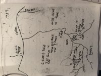
Not sure what this map refers to but looked interesting
View attachment 1867198

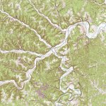
This appears to be the streams and creeks that feed buffalo creek that feeds tygarts creek. This is close to the area i believed the great caverns were. belonging to the family of lewis. This area of carter county was always of interest to me.
 

KY Hiker

Bronze Member
Oct 28, 2014
1,537
3,220
North Central Kentucky
Detector(s) used
Whites
Primary Interest:
All Treasure Hunting
This appears to be the streams and creeks that feed buffalo creek that feeds tygarts creek. This is close to the area i believed the great caverns were. belonging to the family of lewis. This area of carter county was always of interest to me.

Topo map and link to zoomable map of that area.

BuffaloAndTygartsCreek.jpg
PossibleTygartsCreekMap.jpeg

https://www.topoquest.com/map.php?l...ad83&zoom=16&map=auto&coord=d&mode=pan&size=m
 

Last edited:

Curtis

Hero Member
Sep 3, 2008
898
1,008
Cincinnati
Primary Interest:
All Treasure Hunting
Great post of really relevant information! I am about sure this is the same guy who got me an Jay Mathis started looking for Swift things back in the 1970s do you know if he work at National Mines Service company?

By the way the barrels of silver could be the ones mentioned in the Indian Way Bill! Even more coincidental info.
 

KY Hiker

Bronze Member
Oct 28, 2014
1,537
3,220
North Central Kentucky
Detector(s) used
Whites
Primary Interest:
All Treasure Hunting
Great post of really relevant information! I am about sure this is the same guy who got me an Jay Mathis started looking for Swift things back in the 1970s do you know if he work at National Mines Service company?

By the way the barrels of silver could be the ones mentioned in the Indian Way Bill! Even more coincidental info.

The two are almost definitely parallel, if not one in the same on topic.
 

sailaway

Hero Member
Mar 2, 2014
623
815
Primary Interest:
All Treasure Hunting
James Wilkinson, (born 1757, Calvert county, Maryland [U.S.]—died December 28, 1825, Mexico City, Mexico), American soldier and adventurer, a double agent whose role in the Aaron Burr conspiracy still divides historians. Wilkinson served in the American Revolution (1775–83) as adjutant general under General Horatio Gates (1777–78). In 1784 he settled in Kentucky, where he was active in the movement for independent statehood. Until 1800 he received a Spanish pension and was officially known as “Number Thirteen.” At the same time, however, Wilkinson worked against the Spaniards. In October 1791 he was given a lieutenant colonel’s commission in the U.S. Army, and after the U.S. purchase of Louisiana he became governor of that portion of the territory above the 33rd parallel.
In 1787 he took an oath of allegiance to Spain and began intrigues to bring the western settlements of Kentucky under the influence of the Louisiana authorities. https://www.britannica.com/biography/James-Wilkinson
The “Spanish Conspiracy” began the same year as your map here. The Spanish were supposed to leave barrels filled with Silver and gold somewhere along the cliffs south of the Ohio River as payment. Wilkinson went to New Orleans to confront the Spanish for failure to pay him as agent 13 and they claimed to have left it where the map points. I find it interesting that aspects of this map have historical correctness.
https://www.nkytribune.com/2018/07/...-politician-american-general-and-spanish-spy/

Just remember if found then preservation is the name of game as it proves why Wilkinson burned the Library of Congress.
 

Last edited:

sailaway

Hero Member
Mar 2, 2014
623
815
Primary Interest:
All Treasure Hunting
loc_hist_graves_unknown_002-737x1024 (1).jpg

Could the map be referring to the graves on red bird creek by the 1600's Indian trail? remember those graves are protected by law. As a Cherokee myself I would hate to see anyone go to jail.
 

Last edited:

KY Hiker

Bronze Member
Oct 28, 2014
1,537
3,220
North Central Kentucky
Detector(s) used
Whites
Primary Interest:
All Treasure Hunting
Sailaway, thanks for the input and article. I am assuming Redbird Creek would be the same Redbird Fork of the KY River? If so, the cairns referred to in the Mrs. Perkins article I was talking about could be the same burials you refer to...but further North and within a 5 mile radius of the modern day town of Campton, KY in the article I read. I have not done much exploring South of the Kentucky River to give any perspective on the 'Warriors Path' in that area. The article I refer to is linked below, again the writer calls her Mrs. Perkins but her name was Timmins by other accounts of her searches in local papers of the time.

https://chroniclingamerica.loc.gov/...ine&y=11&x=13&dateFilterType=yearRange&page=1
 

KY Hiker

Bronze Member
Oct 28, 2014
1,537
3,220
North Central Kentucky
Detector(s) used
Whites
Primary Interest:
All Treasure Hunting
The “Spanish Conspiracy” began the same year as your map here. The Spanish were supposed to leave barrels filled with Silver and gold somewhere along the cliffs south of the Ohio River as payment. Wilkinson went to New Orleans to confront the Spanish for failure to pay him as agent 13 and they claimed to have left it where the map points. I find it interesting that aspects of this map have historical correctness.
https://www.nkytribune.com/2018/07/...-politician-american-general-and-spanish-spy/

Just remember if found then preservation is the name of game as it proves why Wilkinson burned the Library of Congress.

Thank you, I had not heard of this aspect of KY history. Thanks for your input and sharing.
 

Top Member Reactions

Users who are viewing this thread

Top