Tom Kollenborn's Monumented Trail

skyhawk1251

Sr. Member
Nov 9, 2018
307
638
Kingman, AZ
Detector(s) used
Fisher Gold Bug Pro
Primary Interest:
Prospecting
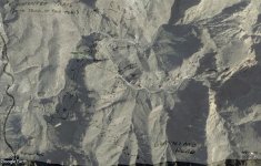
I'm sure everyone who reads and posts to this forum is familiar with the map commonly known as "Tom Kollenborn's Monumented Trail." North is to the left in the image below. I don't know if this map is based entirely on Mr. Kollenborn's personal, on-the-ground explorations, or if it is partially/entirely based on information relayed to Mr. Kollenborn by someone else. Based on what I read in Bark's Notes, Mr. Kollenborn's map looks like an attempt to trace part of the Two Soldiers route into the Superstitions. While some trace the route onto Tortilla Mountain, Mr. Kollenborn traces the route onto Geronimo Head.

------------------------------------------------------------------------

Quote from Bark's Notes on Two Soldiers:

"So, they struck out toward the King, and struck a trail which they had been told was the proper one to take. They followed it for several miles to a creek crossing, where there was water. The trail after that, appeared to run nearly north and the King was nearly south, so while they felt certain that the trail would eventually land them at the King, it must be a long way around, and they were tired. They decided to make a short cut, went up this creek for a distance, CAME TO A WATERFALL, and could go no further. They came back down the creek, and finally go out on the side of the creek toward the King and up on a very rough and high mountain. There was no trail. They struck out, always trying to work toward their destination, but making very slow progress. They ran onto a trail and such a queer place for a trail. They concluded to follow it and see if it wouldn't lead them out of that God-forsaken country. They followed it but a short distance, and were in high hopes when the trail led them THROUGH a cave between the peaks. They went on a little further and came to a tunnel that had been walled up, with workings above and over."

------------------------------------------------------------------------

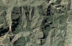
I've attempted to match Mr. Kollenborn's map with topography using Google Earth and I can't do it. Where Mr. Kollenborn has marked "The Trick", I see cliffs with sheer, overhanging drop-offs. I also see no way to negotiate the crossing of Peters Canyon that he indicates on the map. I see no reason for why the monumented section of the trail should need to zig-zag/switchback its way toward Geronimo Head. There seem to be easier route choices toward Geronimo Head. As might be expected, there is no evidence of any trails as they are marked on the map.

If anyone has had success matching the map to topography, please reply here. GPS coordinates for "The Trick" and the Peters Canyon crossing would be helpful.

Monumented Trail.png
 

Idahodutch

Bronze Member
Sep 25, 2019
1,822
4,670
Idaho
Detector(s) used
Whites MXT
Gold Legend
Primary Interest:
Other
Good morning Skyhawk,
I haven’t studied the 2 soldiers, other than a little reading, quite some time ago.
I don’t remember what the starting point was, when “they struck out toward the King”.
I saw a map from one of Glover’s books, like an old military trails map through the superstitions.
This Tom K map you have posted, looks to have Tortilla Flat as the starting point.
Does the story say their trail started there?
(Edit: they were soldiers)
 

Idahodutch

Bronze Member
Sep 25, 2019
1,822
4,670
Idaho
Detector(s) used
Whites MXT
Gold Legend
Primary Interest:
Other
I found the post with the military trails from Glovers book.
It’s located in “Lost Dutchman’s Mine”,
Thread is called “Raise your hand if you have found the Lost Dutchman Mine”, post #386.
 

markmar

Silver Member
Oct 17, 2012
4,113
6,243
Primary Interest:
All Treasure Hunting
Hi skyhawk
Tom was not a professional map maker so i did what was possible to match his map on the ground. You have to take in consideration only the monumented trail and the Peter's Canyon.
You mentioned Bark's notes related to the Two Soldiers story, What is easy to recognized, in that era, all who were writing notes or books, were trying to fit the most stories to their favorite research region. Jim Bark tried to tie the Two Soldiers story to Bluff Spring Mt. using LDM clues and Barry Storm to Black Top Mesa. The truth it's totally different ( IMHO ) and is the Two Soldiers story it's related to the Gonzalez or Haywood mine, which it's not in any of the two regions.
 

Attachments

  • Monumented trail by Tom.jpg
    Monumented trail by Tom.jpg
    259.3 KB · Views: 62
OP
OP
skyhawk1251

skyhawk1251

Sr. Member
Nov 9, 2018
307
638
Kingman, AZ
Detector(s) used
Fisher Gold Bug Pro
Primary Interest:
Prospecting
I haven't studied the 2 soldiers, other than a little reading, quite some time ago. I don't remember what the starting point was, when "they struck out toward the King." I saw a map from one of Glover's books, like an old military trails map through the superstitions. This Tom K map you have posted looks to have Tortilla Flat as the starting point. Does the story say their trail started there? -- Idahodutch

As far as I know, Bark's Notes contain the best, and most complete, telling of the Two Soldiers story. Bark's Notes do not tell exactly where the two soldiers began their journey across the mountains. I, like many other people, take the position that their route followed the Apache Trail to Tortilla Creek, then up the creek a short way. I think they went up "a very rough and high mountain" to get a better perspective of the terrain ahead, hoping to see a trail that might lead in the direction they wanted to go. The whole tale would seem to be improbable if it were not for the two credible witnesses who saw the rich ore the soldiers brought to the Silver King Mine, and the body buried in the shallow grave.

------------------------------------------------------------------------

Quote from Bark's Notes on Two Soldiers:

"So, they struck out toward the King, and struck a trail which they had been told was the proper one to take. They followed it for several miles to a creek crossing, where there was water. The trail after that, appeared to run nearly north and the King was nearly south, so while they felt certain that the trail would eventually land them at the King, it must be a long way around, and they were tired. They decided to make a short cut, went up this creek for a distance, CAME TO A WATERFALL, and could go no further. They came back down the creek, and finally go out on the side of the creek toward the King and up on a very rough and high mountain. There was no trail. They struck out, always trying to work toward their destination, but making very slow progress. They ran onto a trail and such a queer place for a trail. They concluded to follow it and see if it wouldn't lead them out of that God-forsaken country. They followed it but a short distance, and were in high hopes when the trail led them THROUGH a cave between the peaks. They went on a little further and came to a tunnel that had been walled up, with workings above and over."

And an anonymous writer's theory about the route taken by the two soldiers --

Assuming that the trail the two soldiers took out of Ft. McDowell was the Apache trail, then where would the above description put them?
One interpretation would be that they left the Apache trail at the Tortilla creek crossing and they went up Tortilla creek into Tortilla Mtn. There is a good-sized falls on Tortilla Creek there and if it was running would be difficult to pass. If they backed up and got out on the mountain to the South (towards the King), they would have been up on Tortilla Mtn. Since they did not travel far on the mountain they got onto, this would indicate they found the trail on the northern end of Tortilla Mtn. and the mine was in that region. People have written that gold can be panned below the falls on Tortilla Creek.

------------------------------------------------------------------------
 

OP
OP
skyhawk1251

skyhawk1251

Sr. Member
Nov 9, 2018
307
638
Kingman, AZ
Detector(s) used
Fisher Gold Bug Pro
Primary Interest:
Prospecting
Tom was not a professional map maker, so I did what was possible to match his map to what is on the ground. You have to take in consideration only the monumented trail and Peters Canyon. You mentioned Bark's Notes, relating to the Two Soldiers story. What is easily recognized is that in that era all who were writing notes or books were trying to fit the most stories to their favorite research region. Jim Bark tried to tie the Two Soldiers story to Bluff Spring Mt. using LDM clues, and Barry Storm to Black Top Mesa. The truth it's totally different (IMHO) and it is that the Two Soldiers story is related to the Gonzalez or Haywood mine, which are not in any of the two regions. -- markmar

Yes, markmar, you're precisely correct about writers giving top priority to their personal, favored places. That is why we should always be skeptical about what we read in print, regardless of what the topic might be. And excellent graphics work, markmar, as usual. I like the way you handled the "monumented trail" portion of the map. Those zig-zags definitely could indicate a route up-and-over ridges, rather than switchbacks up a single mountain. Let me know if you can spot the faint remnants of any trails in that region.

Monumented trail by Tom.jpg
 

markmar

Silver Member
Oct 17, 2012
4,113
6,243
Primary Interest:
All Treasure Hunting
Yes, markmar, you're precisely correct about writers giving top priority to their personal, favored places. That is why we should always be skeptical about what we read in print, regardless of what the topic might be. And excellent graphics work, markmar, as usual. I like the way you handled the "monumented trail" portion of the map. Those zig-zags definitely could indicate a route up-and-over ridges, rather than switchbacks up a single mountain. Let me know if you can spot the faint remnants of any trails in that region.

View attachment 2030239
Yes, I was able to distinguish a faint trail to the top. If you put GE in 2017 maybe you will be able too.
PS
Forgot to mention how every trail in a rocky region it's " monumented " because of difficulty to see it. People used to put piles of rocks ( usualy few flat rocks one above another in a row ) in regards to be able to follow the trail.
 

Attachments

  • faint trail.jpg
    faint trail.jpg
    345.8 KB · Views: 60
Last edited:

Top Member Reactions

Users who are viewing this thread

Latest Discussions

Top