skyhawk1251
Sr. Member
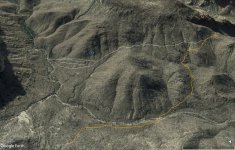
For all Google Earth images inserted below, GPS coordinates at the bottom of the images are for the center of each image. The red box in the first image encloses the area of interest.
I've seen many trails on the slope of this mountain that seem to indicate much human activity in the past. Because those trails took considerable time and effort to construct, but seem to begin and end in improbable places, I associate those trails with prospecting for minerals.
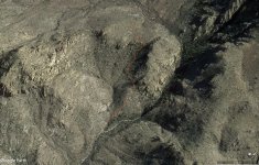
In the second image, notice the unusual geology, and the trail that seems to lead to it. This is most probably a volcanic blowhole, and the trail could be just a natural fissure. I see no evidence of a mine dump.
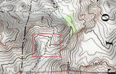
The third image shows the network of trails on the mountain, with the "blowhole" inside the red box.
When I search areas for mining activity, I give priority to following trails. Those trails could lead to prospects and mines, especially if they seem to go nowhere and end suddenly.


I've seen many trails on the slope of this mountain that seem to indicate much human activity in the past. Because those trails took considerable time and effort to construct, but seem to begin and end in improbable places, I associate those trails with prospecting for minerals.
In the second image, notice the unusual geology, and the trail that seems to lead to it. This is most probably a volcanic blowhole, and the trail could be just a natural fissure. I see no evidence of a mine dump.
The third image shows the network of trails on the mountain, with the "blowhole" inside the red box.
When I search areas for mining activity, I give priority to following trails. Those trails could lead to prospects and mines, especially if they seem to go nowhere and end suddenly.