Treasure island's treasures

Ramiro valdez

Full Member
Aug 26, 2020
182
103
San Antonio, Texas
Primary Interest:
All Treasure Hunting
Treasure Island?s treasures


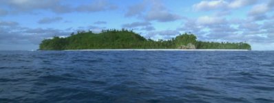
Before I get deep into the discovery I like to lead the explorer into my personal story that led to the find. Treasure Island was a name given to a mysterious island that contained treasures, in the late 1700?s. An explorer will never venture into exploring places without some kind of evidence, that will lead him/her to the treasure, containing common sense. The common sense part replaces that which is unwritten or unrecorded. Therefore one will search all that is written historically and evaluate all the stories pertaining to the subject in search for what makes common sense. You must search for what is unwritten because what is written has already been discovered. The combination of both will help you creat your own personal story of what may have happened and it will lead you in the right direction of finding other leads or evidence to what your looking for. It opens up opportunities to roads that have never been explored before. Therefore treasure hunters look to the tall tell stories that make sense in discovering that which has never been discovered. So everyone?s personal story should contain three things, what is written, what is not written containing common sense, and the information that you?ve found will help piece together the three in order to create a story that will make sense to an explorer who is going to spend a lot of money in the discovery of the treasures. With that in mind I will proceed to tell a tall tell story that makes sense. This story is for those who have been looking for the lost treasure island. This is going to bring focus to areas that have not been explored before on this particular island. I hope that you take only that which makes sense to you in hopes of discovering more details of what actually happened. This is more of an informative story for your entertainment. Enjoy! Soon! coming! And if you know me? And the search I?m accustomed to, then you might want to jump the gun and start studying the history of the Vanikoro Islands, Blaine being the largest then Teanu followed by three other small islands. The Europeans had first sighted the islands in 1595, but were never mapped. In 1788 an explorer named Jean Francois De La Perouse unintentionally landed on the Vanikoro islands. Their mission was to find and map a valuable unclaimed piece of land which they could claim for France by installing a settlement. Bad luck stroke, with no choice but to map an island only for three reasons, treasure, treasure, treasure, which they could not take or use describe on a personal map that they called skeleton island because of the attached smaller island?s detail outline that resembled a skull, the name given to the smaller island. Like I said before, do not under estimate the research?
 

Last edited by a moderator:

freeman

Sr. Member
Apr 5, 2003
346
665
This will be interesting. They were called the Solomon Islands for a reason that few realise.
 

KANACKI

Bronze Member
Mar 1, 2015
1,445
5,927
Primary Interest:
All Treasure Hunting
Hola Amigo

I think I know the island your referring to? The island is very small I sailed around it once and landed there. About half a mile circumference. From above the island looks like a skull. its teeth or jaw in the cliffs of the northern part of the island where it is sheltered from the prevailing winds. Which is the best place to anchor a vessel. In the north western corner's in a good landing beach free of coral protrusions. There was about 200 maybe more people living on the island in living in palm leave huts predominantly on the southern side..

A bit weary of strangers but if they warm to you they are very friendly and communal sharing everything. Most of the islanders are Polynesian stock. The island being so small its one of most densely populated places on earth. How so many people manage to live substantially on such a small island with few resources is really amazing.

They only take what they need and everything in done communally. They live a very traditional simplistic lifestyle mostly free of western influence. They do not get to see many outsiders.

Perhaps a treasure in itself free from us amigo?

But please forgive me please do continue......

Kanacki
 

Last edited:
OP
OP
R

Ramiro valdez

Full Member
Aug 26, 2020
182
103
San Antonio, Texas
Primary Interest:
All Treasure Hunting
Welcome to the Black pearl, gentlemen! I’m only the compass on this ship and I have no doubt that Freeman is a navigator that can steer the ship! KANACKi! You DEVIL! You! You have eyes on the ground! You will be of much use! when this story reaches ground in search of the three treasure locations. All positive comments that add or keep this story moving forward are greatly appreciate. Maybe there is more pirates that want to jump ship, into this ship? Who knows? Must move on.


Two ships under the command of La Perouse named the Boussole and the Astrolabe ran into a fierce storm northwest of the island of Nendo in the Pacific Ocean. The storm came, like a thief in the night, with zero visibility forcing the two ships to reverse in direction. The Boussole took a left turn and the Astrolabe took the right turn, both ships circled back towards the southeast away from the storm. Miles away they spotted each other by light signals and the Boussole decided to intersect the Astrolabe by turning eastward, for safety reasons. As they came close to each other the Boussole ran into the western reef of the Vanikoro islands. The Astrolabe also ran into the outermost northern corner of the reef barrier. The Boussole hit the lower part of the reef and slowly sank into the waters. The Astrolabe was riding stronger waves and the impact forced the ship to hop onto the reef anchoring itself to the broken reef which kept the broken ship afloat. The ship sawed itself into the reef as it floated back and forth until it was dismantled. Immediately after the impact the Boussole and Astrolabe evacuated their cargo as quickly as possible during the night. By morning the only broken ship floating, guarded by a few men, was the Astrolabe. The Nendo Indians, who did not appreciate the European, surrounded the Astrolabe’s crew. Fighting broke out and the Indians ended up killing all the crew members guarding the ship. The fighting alerted a second group of survivors on the island, to come to the rescue. It was a larger number that stroke fear in the Indian’s eyes which cause them to retreat and never come back. The Astrolabe’s crew camped near the ship on the outermost northern part of the island installing an outlook post on a mountain nearby overlooking the northwest and northeast corners. The Boussole’s crew guarded the west, south and southeast, for on coming hostile Indians. The Boussole was carrying a very large amount of precious cargo forcing La Perouse to divide and was buried in two separate locations. The Astrolabe buried their precious cargo in one area north of their camp. The two camps worked together in dismantling the remains of the Astrolabe which were taken to the western side of the island, for safety reasons, in order to build a small schooner that would help them leave the island.They created a map containing the necessary information plus treasure location which was to be delivered to the French government secretly to help recover the buried treasure. This map will be come a reality as soon as the story unfolds. Be patient I don’t get paid for telling this story, so stay tuned for tomorrow’s addition. Enjoy
 

OP
OP
R

Ramiro valdez

Full Member
Aug 26, 2020
182
103
San Antonio, Texas
Primary Interest:
All Treasure Hunting
This treasure map was secured by the commanding officer aboard the newly built schooner that left the island. The crew made it to Murray island where they fought the natives and were all killed except for a young boy. This boy eventually left the island with two native young girls and was never seen again. Someone found the map and the map was eventually sold to a merchant ship or pirate because it contained information about three treasures on a mysterious island. Just about everyone would have mistaken this map to be a pirate treasure than a government buried treasure. The map made it to the Caribbean region because it was the hot spot of buried treasures. This makes sense, but it doesn’t make sense for this particular map. There goes the saying that 90 percent of treasure that cannot be found has to do with the individual being in the wrong continent, wrong Ocean, wrong island, wrong map, wrong clue, and wrong place. The reason why I mentioned the two shipwrecks was because the natives claim that there was two groups on the island. That meant two ships, two camps, two cemeteries that will define their specific locations. The cemeteries are probably located on a hill over looking their respective shipwrecks. The Vanikoro Islands will produce the evidence that a French map did exist containing monumental structure and details belonging to said island. The initial tall tell story gave away a few clues. This map obviously was made by a very good knowledgeable sailor who knows his ship’s. The creator of the map named the necessary monumental structures using proper 1700’s ship language. He found the highest hills on the north and south part of the main island. He named the outer most northern hill, foremast hill, and the southern hill mizzenmast hill. He could have reversed the names but that would not make sense for a ship that was supposed to be traveling towards the north. If your a sailor, you can understand, and I have no doubt that Freeman, being a sailor himself, most definitely understands the language. Thats why I chose him to navigate the black pearl. KANACKi, has given evidence of a monumental structure that is very important to the story and perhaps he knows more? At this time all the rebel negative pirates are making all kinds of noises in disbelief cause it makes too much sense? Well, they better get use to it because the rest of the way the noise only gets louder. People who are not familiar with this legend are falling behind and I want to give them a chance to catch up. Those who know enough have enough clues to move on go ahead. Enjoy
 

KANACKI

Bronze Member
Mar 1, 2015
1,445
5,927
Primary Interest:
All Treasure Hunting
This treasure map was secured by the commanding officer aboard the newly built schooner that left the island. The crew made it to Murray island where they fought the natives and were all killed except for a young boy. This boy eventually left the island with two native young girls and was never seen again. Someone found the map and the map was eventually sold to a merchant ship or pirate because it contained information about three treasures on a mysterious island. Just about everyone would have mistaken this map to be a pirate treasure than a government buried treasure. The map made it to the Caribbean region because it was the hot spot of buried treasures. This makes sense, but it doesn’t make sense for this particular map. There goes the saying that 90 percent of treasure that cannot be found has to do with the individual being in the wrong continent, wrong Ocean, wrong island, wrong map, wrong clue, and wrong place. The reason why I mentioned the two shipwrecks was because the natives claim that there was two groups on the island. That meant two ships, two camps, two cemeteries that will define their specific locations. The cemeteries are probably located on a hill over looking their respective shipwrecks. The Vanikoro Islands will produce the evidence that a French map did exist containing monumental structure and details belonging to said island. The initial tall tell story gave away a few clues. This map obviously was made by a very good knowledgeable sailor who knows his ship’s. The creator of the map named the necessary monumental structures using proper 1700’s ship language. He found the highest hills on the north and south part of the main island. He named the outer most northern hill, foremast hill, and the southern hill mizzenmast hill. He could have reversed the names but that would not make sense for a ship that was supposed to be traveling towards the north. If your a sailor, you can understand, and I have no doubt that Freeman, being a sailor himself, most definitely understands the language. Thats why I chose him to navigate the black pearl. KANACKi, has given evidence of a monumental structure that is very important to the story and perhaps he knows more? At this time all the rebel negative pirates are making all kinds of noises in disbelief cause it makes too much sense? Well, they better get use to it because the rest of the way the noise only gets louder. People who are not familiar with this legend are falling behind and I want to give them a chance to catch up. Those who know enough have enough clues to move on go ahead. Enjoy

Holla Amigo

I know the story well of The Vanikoro Islands in 2005 there where the French government as involved in major Archeological expedition recovering artifacts from the shipwrecks.

I have a lead sounding weight from the Astrolabe. I use it as paper weight on my desk. Here is some pictures of the expedition in 2005 run by teddy Seguin they did extensive search and recovery of artifacts on the reefs and on shore where survivors camped. Here is a painting of the two explorations ships.

2687713_orig.jpg

Here is picture of the recovery of cannon below.

vk14.jpg

Cannon on the coral reef.

vk01.jpg

some artifacts recovered a skull of a sailor.

found skeleton.jpg

skull.jpg


I have heard of the story young french cabin boy survivor in the Murray island Torres strait but I have not heard of this alleged story of a map?

images.jpg

Ramiro your comments are interesting but who was the source of these claims Below?

Someone found the map and the map was eventually sold to a merchant ship or pirate because it contained information about three treasures on a mysterious island. Just about everyone would have mistaken this map to be a pirate treasure than a government buried treasure.


I like hear more about this alleged map?

Kanacki
 

Last edited:
OP
OP
R

Ramiro valdez

Full Member
Aug 26, 2020
182
103
San Antonio, Texas
Primary Interest:
All Treasure Hunting
Thanks, KANACKi, you have inspired me to tell more of what I have to tell. Nothing please me more, at this point in life, but to help those who seek to discover lost history that pertains to the French lost expedition. Forgive me for not being quick about it, because I’m geared more towards searching for lost history than pleasing greedy treasure hunters who are just concerned with the treasure’s location since the information is given freely. But for you I’m going to speed it up this week. After this I will venture into some stone that were unturned which will help me unfold the Nazi German Lue treasure map. I have no use for that treasure anyways. So do stick around, I love your in put, no! No! Now I really hate you for venturing into places I never have set foot in. Just jealous!!! Lol!! No harm meant. Thank you, again, KANACKi!
 

Crow

Silver Member
Jan 28, 2005
3,318
9,260
In a tax haven some where
Detector(s) used
ONES THAT GO BEEP! :-)
Primary Interest:
Other
Gidday amigos


Here is a picture of the island referred to as skull island.

attachment.php


It is one of the most unique islands in the Pacific. Home to one of last Polynesian tribes that live a traditional island lifestyle as their for fathers did 200 years ago. Their neighbors across the ocean from them are all Melanesian.

Most islanders throughout the pacific has adopted trappings of western world. such as tin motor boats etc...This group of Polynesians live virtually like their ancestors and fish by traditional canoe. Everything in the tribe is communal.They live in palm tree huts. They still use canoes over 200 years old which are beautiful museum pieces.

attachment.php


In essence the 3 hundred or so islanders crammed onto such a small island all appear very healthy. They totally reject western medicine. The live under philosophy that if you are sick or deformed in anyway nature decide weather you die or not. Even the older people seen healthy. They live with the total absence of junk food, no sugar tee or coffee, no alcohol chocolate or processed food. They drink water, coconut milk, eat coconuts fish, chick and bird eggs and other sea food. And by what is gown in there gardens breadfruit taro yams and other vegetables.

No TV refrigerators or electricity. They might see 2 or 3 people from the outside world once a year. There was only one island that can speak english he is used as an interpreter as they speak ancient Polynesian. If you want to eat you have go out and catch it or grow it. They cook and share their food communally. If a family has no children another family with lots will give some of their children to childless couples. Kid are healthy and very happy with none of toys and crap our kids have.

attachment.php


The only entertainment is singing and dancing traditional Polynesian songs and stories long forgotten on most other Polynesian islands. When darkness falls they sleep when daybreak breaks they up fishing or working in their gardens. Their world is very uncomplicated they have no concept of money and none of our neurotic worries we have. No fears of making debt repayments to the bank. no credit cards or work issues. No mobile smart phones not internet, no computers none of the vices we have and most of all amigos, No Bills!

In essence they have a freedom that many people envy.

Forgotten by most even by the most intrepid tourist or adventurer. There is part of me hope they stay lost and forgotten.

Perhaps a priceless treasure in itself?

Crow
 

Attachments

  • anutaisland3.jpg
    anutaisland3.jpg
    75.7 KB · Views: 182
  • image-3.jpg
    image-3.jpg
    170.2 KB · Views: 172
  • image-4.jpg
    image-4.jpg
    156.6 KB · Views: 177
Last edited:

KANACKI

Bronze Member
Mar 1, 2015
1,445
5,927
Primary Interest:
All Treasure Hunting
Hola Crow amigo

Indeed for the islanders sake I will not give the true name but it is true looking south from above the island resembles a skull. Hence the nickname by outsiders as skull island.

facing south the island is shaped like a skull..JPG

Kanacki
 

Last edited:
OP
OP
R

Ramiro valdez

Full Member
Aug 26, 2020
182
103
San Antonio, Texas
Primary Interest:
All Treasure Hunting
I often wonder what La Perouse was bringing the king? Louis XVl was so insisting on wanting to see him all the way to the very last day of his death. What news did La Perouse have for the king? The Vanikoro island’s might contain buried information that might answer some questions to what La Perouse had on board. A young writer, a long time ago, named Robert Louis Stevenson gathered as much information as he could about a lost mystery island treasure map containing several treasures. After many years of not finding the island he was confronted by an amazing idea given to him by his stepson who was creating a treasure map story of his own. The writer venture into writing a fiction book called treasure island. He created a map that contained a lot of the information he had gathered and combined it with a mental vision of what the island might of looked like to those who claim her existence. But that part of the story has changed because the writer was know to sometimes take other writers material to incorporate as his own and when he submitted his treasure island book story it was denied on the basis of the map he had attained with someone else’s handwriting. Someone in the company kept the map which floated around until someone recently caught it and displayed it on Pinterest. The book writer had to recreate a mental map vision of his own creation. The information on the second map did not have all that was on the first map and Mr. Stevenson was not happy with the way it came out the second time. The map was more of a tribute to all whom had help him in trying to find the mystery treasure island. These two maps are just mental creations of what the original map may have looked like that has never been found. The map that just surfaced carries other important information that is going to be helpful down the line, information that Mr Stevenson forgot? The treasure map story doesn’t describe a pirate’s treasure, cause, most pirate’s treasure maps don’t carry a lot of detail information. The mystery island map in question describes a story about an island that was occupied for quite sometime. To have a spyglass hill only indicates that they were guarding certain things. Every monumental structure that was mentioned and inscribed on the map happens to belong to this mystery island. And I must say that using monumental structures is the most effective way to lead someone to your treasure. So given the fact that he used fiction in combination with non fiction tells us that the story contained gathered information especially on the map that he created. Therefore I have to say that the island that he drew was not going to be exactly as the island in question? But he stood a good chance that the monumental iconic symbolic structures would eventually be found exposing the true island’s graphic features. The Vanikoro island’s have a lot tell about where the mystery map came from and why the map was created. The map is looking for its island and the Vanikoro island’s are looking for their map. A map that carries monumental symbolic features belonging to the Vanikoro island’s. Some of these features have been overlooked by the seeing eye? Why? Well, the truth is that it’s hard to see a lot of things from ground level. So let’s take the Grande tour of the Vanikoro island’s and I must insist the you carry along your treasure island handbook map with you at all times because we are going to correct that which is out of place. Try not be confuse with the map that belongs to the island because the island will always take precedence over the map. This Island was an uninhabited island that was not inviting and very dangerous to those who never been on the island, keep that in mind. The La perouse’s story is the only story that has anything to do with this Island and therefore he wrapped himself around the island’s history which makes him the number one suspect to also include that he was capable of producing a map of the island, a French map to be exact if I may say so. The mystery map describes that someone’s precious cargo was left on the island and if you search for the ship or ships you will not find that specific cargo? Why is it so important that we mention ships? Well? You must inquire on the reason of why Mr Stevenson had two graphic ship’s on his map? I’m sure he didn’t know the reason behind that other than someone claiming that the map contained two unknown ships. The first map that Stevenson lost actually had the two ship’s in the proper location. So! Let’s crack on! We are going to take a free tour of the amazing Vanikoro island’s starting with the most northern hill, labeled by the map as the foremast hill, from there we will paddle our way around the island towards the northeast. Across from the hill towards the north will be the spirit of the Astrolabe, the first ship on the map, located on the outer northern reef corner identified by the mark he left on the reef barrier. As we move on you will be passing sacred ground that belongs to the crew of the Astrolabe. Further down you will run into the northern inlet which can take you into the northern camp belonging to the Astrolabe group. Not far, as we paddle the boat you will find the spring forest where the water comes in and out towards the ocean. At this point you’re probably confuse with what to follow, the map? Or the island? You must follow both and correct that which is wrong on the map, because it was created by a mental vision of what it might look like. As we move on down the eastern coastline you will run into another monumental structure located on top of the outer reef barrier. This is what the French called the roule’ sur cove. Yes! It’s a French word! For a French map! The meaning describes a rectangular cove that dries up a it during the summer exposing several lip lines which is from where it gets its name. It is an amazing monumental structure that you can’t miss because of its vegetation that’s always growing in its center.This is something that should go on a map to say that most pirates wouldn’t care about it unless they were burying their treasure on it? This is the difference between mapping an island and mapping a pirates treasure map. This map has too many details for being a pirate’s treasure map? If you don’t believe me, then you should check all the pirate’s treasure maps? We are not even halfway, but you should start considering what the Vanikoro island’s are trying to say? We should move on to some bigger and better things. As you come down towards the southeast corner of the mainland your going to run into white rock! The edge surrounding the left and right side of the southeast corner is not covered with rocks as the graphics indicates on the treasure map. No! The edges are covered by plain consistent white rock as the word implied. You must correct your map’s graphic design, at this point. Miss information will always lead to lost history. We will now turn right around the southeast corner of the mainland and head towards the west. First we must identify the dangerous and unforgivable swamps located to the right that leads to the central mainland. Now! We can discuss the small island to the left called skull island? It gets its name from its natural graphics features when viewed from a specific hill located on the southwest section of the mainland. From there you could also spot the neck extension that connects skull island to the mainland which runs underneath the surface of the water. This is the reason why the mainland was referred to as skeleton island. I could relate to the name because it has taken and buried many other skeletons. So we should call the mainland skeleton island? As we move on we are forced to go around the arrowhead extension where the mizzenmast hill is located. Out looking towards the west in front of the mizzenmast hill you will see the haulbowline entry point which allows bigger ships to enter the bay. Haulbowline’s are very rare and their graphic design cannot be found just anywhere. This is another reason why the maps or map keep pointing to the Vanikoro islands. As we make way up the west coastline you will encounter a strategic hill on the right. This! My friend was the most important hill which the French labeled spyglass hill! Why? Well, if you could find a better hill capable of spying on the west camp, commanding officers quarters, stockade, devil’s hand rock mountain, southeast white rock corner, skull island, haulbowline entry point, and the west ocean corridor for rescue ships as well as pirates ships? Then let me know so we can change it? As we go past spyglass hill you will run in to the west camp belonging to the Boussole group. The west side of the island normally contains the strongest tides year around unless you run into a hurricane on the opposite side of the island. At this point you should take out the second map that recently surfaced on Pinterest. This map contains added information about the interior of the island starting with the stockade which was located between the west camp and spyglass on a dead end canyon between two hills. The north camp had theirs in an open clearing and left their circular corral imprint which you cannot miss. The map also describes the iconic devil’s hand rock mountain located towards the central mountains of the mainland viewed all the time by spyglass because it contained a buried treasure in its summit. You can find all the photos you need, in locating theses monumental figures on Pinterest under my name, if you like. The second treasure is located beneath spyglass hill facing the devil’s hand rock mountain. The third treasure is located beneath the foremast hill. This is interesting and the word interesting does not describe this tall tall tell, but I’ll take it if that’s all I can take. I believe that there are three other real pirate’s treasures hidden on the island and I have my suspicion. One is on skull island, the other one on the northwest corner of the mainland and the third is on the summit of the western reef barrier not far from the Boussole wreckage. The graphic dictates a large bell, the size of the Dhammazedi bell laying on rafters lodged on the lower bottom of the reef barrier. Call me crazy but someone said that the bell would have deteriorated in three hundred years and I said prove it? Here? On the western reef of Vanikoro island where the waves are always pounding the reef. I’m not an expert, but that, I have to see. This Island has a way of burying many things and has the potential of burying Oak Island? But this is just a tall tall tale from someone who wants to identify the mystery island because without the island there is no treasure. So, if you can help me, then pitch all your questions to the explorer who can find the real answers to this tale? Thanks, again my friends, I enjoy telling tales because it keeps some of you on your toes. I have some unsettling business with stones that talk about Virginia. I’m, sorry! I should have not said Virginia because it upset certain people? But, I’m still going to use them to unfold the Nazi German Lue Map. So I’m signing off this thread to continue another treasure find. Good luck with my story and I hope someone can make use of it.
 

KANACKI

Bronze Member
Mar 1, 2015
1,445
5,927
Primary Interest:
All Treasure Hunting
Hola Amigo

A tale indeed. What you claim to me seems very detached from reality of what is actually there. I think you need to reassess your research methods and go and see the place yourself. Making google earth observations and linking random events never leads to treasure amigo.

I suspect your conclusions will turn out to be very different if you do?

Kanacki
 

Attachments

  • 1057498.jpg
    1057498.jpg
    45.2 KB · Views: 68

freeman

Sr. Member
Apr 5, 2003
346
665
I've lost count of the copies of 'authentic' treasure maps' I have for '3 treasures on an island' (generally in triangle layout) that comes from a cabin boy/the one who was not hung/the sailor who died in bed.......
 

Last edited:

KANACKI

Bronze Member
Mar 1, 2015
1,445
5,927
Primary Interest:
All Treasure Hunting
Hola Freeman

It is tired old theme. Social folklore. But here is the problem most Academics declare the treasure map theme an invention of RLS yet the facts remain such stories was about long before RLS.

As the popularity of treasure maps grew after treasure island book so did the hoaxes of treasure maps grew. Several reasons why this came about. One lack of welfare of old seamen too old to sail. What old salt would not have a treasure yarn or a map or two to sell to keep them out of a poor house.

Same as the Spanish prisoner scam came about. This and oportunists cashing in on the craze in one form or another by 20th century treasure book authors.

There are a few maps out there that have historical prevnce long before RLS.

Kanacki
 

Top Member Reactions

Users who are viewing this thread

Top