Video 4 - The Peralta Stone Maps with Frank Augustine

somehiker

Silver Member
May 1, 2007
4,365
6,426
Primary Interest:
All Treasure Hunting
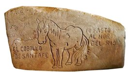
I would not put much stock in that stone. I believe it's the one Wayne found. The truth behind the stones came out later. I did find a piece of ore at that spot. Looked like someone busted it open after transporting it there.

Hi Frank

I would think many prospectors rode and walked across that area, between their mines and Florence, for example.
Maybe even Waltz, when he stayed in Florence, or went for supplies. Coulda dropped some right there.
 

Holyground

Hero Member
May 17, 2014
579
828
Not in the can
Detector(s) used
Garrett AT GOLD, Garrett ATX
Primary Interest:
All Treasure Hunting
Quite unlikely, though, that a group of four people, two with lucrative jobs, should band and form a conspiracy to sell two or more fabricated Stone Crosses, with misspelled Spanish.

Why would Bilbrey then move from San Diego to be closer to the Superstitions (he ended up in Casa Grande) just to perpetuate a hoax?

And furthermore how did they know to craft the crosses with asymmetrical arms, when we never see the back of the upper trail stone in the 1964 Life Magazine article which Bilbrey reportedly consulted before setting out on his journey?

And why should Bilbrey and Farr then pretend to have internal strife or dispute resulting in the breakup of the group and the locking up of the Stone Crosses in a vault, never to be seen again? In what way does this enhance or make more valuable, the "selling" point of the hoax or the Stone Crosses?

These are facts that Joe and others chose to ignore.

Possessing a great deal of information does not make you an expert in anything without the faculty to remain objective, to avoid making judgment or forcing facts to fit a preconceived theory. More important, I think, is the willingness to be flexible in the face of new evidence.

Someday, I believe, everyone will realize that Bilbrey found one of the most integral parts of the Jesuit Stone Maps. There's probably one small item, on one of them, that makes the others just as vital...all together.
 

Al D

Bronze Member
Jul 23, 2011
2,066
3,524
Gold canyon AZ
Detector(s) used
DJI Air 2S
Primary Interest:
Cache Hunting
Someday, I believe, everyone will realize that Bilbrey found one of the most integral parts of the Jesuit Stone Maps. There's probably one small item, on one of them, that makes the others just as vital...all together.

Just wonder, why do you call them Jesuit stone maps?
 

Azquester

Bronze Member
Dec 15, 2006
1,736
2,596
Primary Interest:
All Treasure Hunting
After many years of studying the faked stone maps with real map feature's I finally figured out one conclusion. The Horse map I always assumed the word "Milli" stood for the Spanish Castilian measurement of one mile. It took me a while to finally understand and use the system of measurement depicted.

The word "Milli" was meant to represent, "Milliare" or simply the Meter.
3.28 modern feet.

Mid 1600's France Gabriel Mouton invented the meter. This is what the Peralta Horse map portrays on it's mane.

1393.175 meters in the Spanish Milla.

1.0933 modern feet times three in the Meter.

All coded measurements at the site that the Horse Map may lead one to will be set up in meters for length and degrees for direction "FROM THE GROUND MONUMENTS".

This is the only system of measurement that explains the distance between the boulder or rock pile monuments carved or laid out on the ground at a real Peralta Horse map treasure site.

This should direct anyone to a hidden Mine or Treasure vault entrance. This is different from the 2.74247 feet of the Castilian Vara compared to our system. Try using the meter next time you measure that Milla and you'll see that it finally makes sense.

1847 Meters 1.33 Milla or 1 1/3 Milla

25=25% of a Milla in meters or 25% of 1393.175 meters. 348.25 meters or 1/4 Milla Castilian.

2-5 = 3 degrees declination off the monuments. Multi Directional. You must check all four directions. This is just an example not what you may find.
You'll find an entrance either by or directly in the side of a "Rio".


sgtfda

Bronze Member
Feb 5, 2004
2,351
3,885
Mesa Arizona
After many years of studying the faked stone maps with real map feature's I finally figured out one conclusion. The Horse map I always assumed the word "Milli" stood for the Spanish Castilian measurement of one mile. It took me a while to finally understand and use the system of measurement depicted.

The word "Milli" was meant to represent, "Milliare" or simply the Meter.
3.28 modern feet.

Mid 1600's France Gabriel Mouton invented the meter. This is what the Peralta Horse map portrays on it's mane.

1393.175 meters in the Spanish Milla.

1.0933 modern feet times three in the Meter.

All coded measurements at the site that the Horse Map may lead one to will be set up in meters for length and degrees for direction "FROM THE GROUND MONUMENTS".

This is the only system of measurement that explains the distance between the boulder or rock pile monuments carved or laid out on the ground at a real Peralta Horse map treasure site.

This should direct anyone to a hidden Mine or Treasure vault entrance. This is different from the 2.74247 feet of the Castilian Vara compared to our system. Try using the meter next time you measure that Milla and you'll see that it finally makes sense.

1847 Meters 1.33 Milla or 1 1/3 Milla

25=25% of a Milla in meters or 25% of 1393.175 meters. 348.25 meters or 1/4 Milla Castilian.

2-5 = 3 degrees declination off the monuments. Multi Directional. You must check all four directions. This is just an example not what you may find.
You'll find an entrance either by or directly in the side of a "Rio".


The horse map was made by Travis, his daughter and a old Mexican. It's total bull. The trail maps were made using Peg Legs old map.
 

Azquester

Bronze Member
Dec 15, 2006
1,736
2,596
Primary Interest:
All Treasure Hunting
The horse map was made by Travis, his daughter and a old Mexican. It's total bull. The trail maps were made using Peg Legs old map.
I said Fake. I know you were there and talked with them while rummaging through Travis's lost Storage Unit when you found the Peggy map. Although many would like to see the real McCoy posted on here I have a feeling that'll never happen. If the family carved Horse map is total bull and not from a Peg Leg map the kinfolk sure nailed the symbolism down by pure dumb blind ass drunken lolly pop kids luck. Both Elephants and Horses are depicted in stone carvings at these sites which I've posted pictures of in the past.
To me, and many others, the maps that were created to both help Travis with his hunting and to explain to him what each piece means from the Peg Leg Map as a cartoon character joke still holds some mining symbolism. Debunking it like RG did to your show is your purgative. You heard it from the Horses mouth so to speak and we didn't. Even so, the Horse Map still has that hint of Spanish lost mines. We all know it has some vague significance. Even if you claim it's a Father, Child, Mexican, induced fabrication. RG said the same after all his self serving research. It sounds to me like the family is still playing the joke that Travis started years ago.

Only the trail map is real?
Where does that lead to?
Is it where RG had the Treasure stolen right out from under him by that famous GP Radar Man?


Now that was a absolutely hilarious show!

If the Horse Shoe Fits wear it!
 

Azquester

Bronze Member
Dec 15, 2006
1,736
2,596
Primary Interest:
All Treasure Hunting
Another thought. The trail map has the numerals on it in that first post as being in "Meters" and "Degree's". That's what I was referencing to as the dual numbers. The Horse Mane "Milli" thing may just be coincidental on Travis's part, or maybe not. The Trail Map also has numerous symbols that mimic the fabricated horse map. So, they must've used a mix of symbols in all of the carved rock doorstops. It's amazing how some of it fits in the field and some of it don't.
I don't expect another answer from you Frank it's just an observation. When it comes to responses you seem to shoot down posts with one sentence and then disappear never responding or answering sort of a
"One Shot Willy".

Good Luck
 

markmar

Silver Member
Oct 17, 2012
4,117
6,259
Primary Interest:
All Treasure Hunting
Another thought. The trail map has the numerals on it in that first post as being in "Meters" and "Degree's". That's what I was referencing to as the dual numbers. The Horse Mane "Milli" thing may just be coincidental on Travis's part, or maybe not. The Trail Map also has numerous symbols that mimic the fabricated horse map. So, they must've used a mix of symbols in all of the carved rock doorstops. It's amazing how some of it fits in the field and some of it don't.
I don't expect another answer from you Frank it's just an observation. When it comes to responses you seem to shoot down posts with one sentence and then disappear never responding or answering sort of a
"One Shot Willy".

Good Luck
Bill

The Horse stone map it's not fake, nor was made by anyone from Tumlinson family. The horse map it's a locator map which " shows ' where is located the horse landmark in regards to find the church treasure of Holy Faith.
Look at the map and think about the details. There are some treasure codes written on it which could help to decrypt the map.
First, the horse " says " he is grazing north from the river, a river which is depicted to runs east-west, but in the map the horse is carved south from the river ( RIO ). This is not a mistake but prompts to use the codes in the map.

Second, in the map above the RIO, are depicted five dots and the number 5. Those dots and the number 5 are for use in regards to find the horse landmark from a specific spot. Why was carved the number 5 between the five dots? To tell us there are five dots? I don't think so. The number 5 together with the upper dot from the three in a row, shows five degrees angle from a specific cardinal point. After this, the number 5 in combination with the dots, separately with every row, show the distance to the horse landmark from the same specific spot from where was measured the angle. And here is the right time to use the " Mili " from the Horse mane, as the number 1000 but only it's zeroes ( 000 ) at the end of the calculation. The measurement of the distance was made in meters.
 

Attachments

  • d379ec003635eeba9fa9b3887d95a30d.jpg
    d379ec003635eeba9fa9b3887d95a30d.jpg
    53.4 KB · Views: 89
  • Horse landmark.png
    Horse landmark.png
    25.7 KB · Views: 94

coazon de oro

Bronze Member
May 7, 2010
1,623
3,856
texas
Primary Interest:
All Treasure Hunting
Howdy Azquester,
This story was made up just like arcana exploration's, and all the other found it, solved it stories floating around. They all claim to make new discoveries, and will only confuse you more than they are. They take the same pieces of the real puzzle, and arrange them different.

The PSM's are very real, and were buried before Peg Leg was even born, and way before Travis carved the Galleon/Treasure chest stone. Travis found the stone maps like he said, Peg Leg was dragged into this story, but had nothing to do with it. They did not come from an old church either, and they don't have coordinates as Ryan claims. The horse's mane is just that, a mane, nothing else.

This world has spun around the sun several centuries since the stones were made, but all the landmarks are still in place. They did not come out of the holes that Ryan and his team of experts claimed either, they had all been buried together, just four stones, and yes in my opinion will lead you to the mine, not treasure, that is written in stone.

Homar
 

Matthew Roberts

Bronze Member
Apr 27, 2013
1,131
4,955
Paradise Valley, Arizona
Primary Interest:
All Treasure Hunting
The truth behind the stone map story. It was never the Travis Tumlinson story, it was the Phillip Leasman story.


In the late teens of the 20th century (1915 - 1920 ) Peg Leg Tumlinson was living at the old Leasman cabin near Stockdale, Texas. Peg Leg Tumlinson was the grandfather of Travis Tumlinson. Phillip Leasman whose family owned the cabin was the uncle of Travis Tumlinson, his mother’s brother.

For the last few years of Peg Leg Tumlinson’s life, Phillip Leasman was taking care of him, bringing him food, doing chores for him and looking after him. At that cabin in those years, 1915-1920, all of Peg Leg Tumlinson’s things were there with him. Many artifacts, documents, maps, statues and numerous stone carvings were stored there.

Peg Leg Tumlinson died in 1920 and immediately Phillip Leasman moved into the old cabin with all of Peg Leg Tumlinson’s things.

Not long after Peg Leg Tumlinson died and Phillip Leasman moved into the cabin he started bringing his nephew Travis Tumlinson around showing him all the things that had belonged to Peg Leg. Travis became a regular at the old cabin.

It was Phillip Leasman who carved a good many of the pictures on the old stone chimney at the cabin. Over the years many carvings on that chimney and on rocks not far from the cabin were carved on by young people in the Stockdale area. Travis undoubtedly did “some” carving but was just one of many who used the area for their artwork. The chimney contains the initials and pictures of numerous people who carved them there and these people were no relation to any of the Tumlinson’s.

To say exactly who carved which pictures and when they carved them on the chimney and nearby rocks is pure speculation. That is the truth of the matter.

In 1933, Phillip Leasman urged and financed Travis Tumlinson to move to a little shack between Florence Junction and Superior, Arizona. Leasman had found a job for Travis at a mine southeast of Florence Junction along Walnut Canyon wash. Several mine claims there were known as the Walnut Canyon claims and were in some rough country. Travis took a job as a tender of the mules and horses used at the mine. The mines were once a part of the Ray Mines Division and today are a part of the Rio Tinto Corporation.

Travis worked there until sometime in 1937. But it was not the Walnut Canyon mine that Phillip Leasman and Travis Tumlinson were interested in. Leasman had sent his nephew (Travis) to that part of Arizona because it was near the area he wanted Travis to explore, an area just a few miles to the west in the Southeastern Superstition Mountains around Hewitt and Millsite canyons and nearby Queen creek.

Phillip Leasman had gotten information from things Peg Leg Tumlinson had shown and told him when Peg Leg was living at the old cabin. From maps Peg Leg possessed, both stone and paper, he believed there were mines and buried treasure in the area. Leasman traveled to Arizona to stay with his nephew and search the area himself when time allowed.

Travis after marrying and having a child, later found work at Hood River, Oregon but over the years, until Travis Tumlinson’s death in 1961, Phillip Leasman and Travis would make regular trips to the area around Queen creek and the southeast Superstition Mountains searching for specific mines and treasure using these maps.

In the early-mid-1950’s Travis Tumlinson and Phillip Leasman did the exact same thing Leasman had done with Travis 20 years earlier. They convinced a close friend, Clarence Mitchell (Travis Marlowe) to move from nearby Leavenworth, Washington to a little place near Florence Junction along Queen creek to look for a specific set of mines and treasure buried somewhere in the Southeastern parts of the Superstition Mountains.

Mitchell moved his family, wife Grace and daughter Carol to Queen Creek, took a job in Apache Junction and went into the Superstitions every chance he got to search for mines and treasure. Travis Tumlinson and Phillip Leasman visited with Mitchell in Arizona and went in the mountains with him when they could.

When Travis Tumlinson died in 1961, Leasman kept in contact with Mitchell and the two continued to search the Superstition area together. Phillip Leasman was at this time fairly unable to physically search the mountains and Mitchell did the leg work for both of them.

Phillip Leasman died in 1970 and by then Mitchell had moved to Placerville, California where he spent the summers but still wintered in Arizona at Queen Creek and Apache Junction. He continued to search for the mines and treasure Travis and Phillip believed hidden in the Superstitions until he could himself no longer hike the mountains.

What began with Peg Leg Tumlinson and later Phillip Leasman in the old cabin near Stockdale, Texas in 1920 lasted for over a half a century. Who knows for how many years before that Peg Leg Tumlinson may have alone pursued the information of mines and treasure buried somewhere in the Superstitions?
 

Dirt1955

Full Member
Mar 10, 2015
190
363
Orange County, CA
Primary Interest:
All Treasure Hunting
The truth behind the stone map story. It was never the Travis Tumlinson story, it was the Phillip Leasman story.


In the late teens of the 20th century (1915 - 1920 ) Peg Leg Tumlinson was living at the old Leasman cabin near Stockdale, Texas. Peg Leg Tumlinson was the grandfather of Travis Tumlinson. Phillip Leasman whose family owned the cabin was the uncle of Travis Tumlinson, his mother’s brother.

For the last few years of Peg Leg Tumlinson’s life, Phillip Leasman was taking care of him, bringing him food, doing chores for him and looking after him. At that cabin in those years, 1915-1920, all of Peg Leg Tumlinson’s things were there with him. Many artifacts, documents, maps, statues and numerous stone carvings were stored there.

Peg Leg Tumlinson died in 1920 and immediately Phillip Leasman moved into the old cabin with all of Peg Leg Tumlinson’s things.

Not long after Peg Leg Tumlinson died and Phillip Leasman moved into the cabin he started bringing his nephew Travis Tumlinson around showing him all the things that had belonged to Peg Leg. Travis became a regular at the old cabin.

It was Phillip Leasman who carved a good many of the pictures on the old stone chimney at the cabin. Over the years many carvings on that chimney and on rocks not far from the cabin were carved on by young people in the Stockdale area. Travis undoubtedly did “some” carving but was just one of many who used the area for their artwork. The chimney contains the initials and pictures of numerous people who carved them there and these people were no relation to any of the Tumlinson’s.

To say exactly who carved which pictures and when they carved them on the chimney and nearby rocks is pure speculation. That is the truth of the matter.

In 1933, Phillip Leasman urged and financed Travis Tumlinson to move to a little shack between Florence Junction and Superior, Arizona. Leasman had found a job for Travis at a mine southeast of Florence Junction along Walnut Canyon wash. Several mine claims there were known as the Walnut Canyon claims and were in some rough country. Travis took a job as a tender of the mules and horses used at the mine. The mines were once a part of the Ray Mines Division and today are a part of the Rio Tinto Corporation.

Travis worked there until sometime in 1937. But it was not the Walnut Canyon mine that Phillip Leasman and Travis Tumlinson were interested in. Leasman had sent his nephew (Travis) to that part of Arizona because it was near the area he wanted Travis to explore, an area just a few miles to the west in the Southeastern Superstition Mountains around Hewitt and Millsite canyons and nearby Queen creek.

Phillip Leasman had gotten information from things Peg Leg Tumlinson had shown and told him when Peg Leg was living at the old cabin. From maps Peg Leg possessed, both stone and paper, he believed there were mines and buried treasure in the area. Leasman traveled to Arizona to stay with his nephew and search the area himself when time allowed.

Travis after marrying and having a child, later found work at Hood River, Oregon but over the years, until Travis Tumlinson’s death in 1961, Phillip Leasman and Travis would make regular trips to the area around Queen creek and the southeast Superstition Mountains searching for specific mines and treasure using these maps.

In the early-mid-1950’s Travis Tumlinson and Phillip Leasman did the exact same thing Leasman had done with Travis 20 years earlier. They convinced a close friend, Clarence Mitchell (Travis Marlowe) to move from nearby Leavenworth, Washington to a little place near Florence Junction along Queen creek to look for a specific set of mines and treasure buried somewhere in the Southeastern parts of the Superstition Mountains.

Mitchell moved his family, wife Grace and daughter Carol to Queen Creek, took a job in Apache Junction and went into the Superstitions every chance he got to search for mines and treasure. Travis Tumlinson and Phillip Leasman visited with Mitchell in Arizona and went in the mountains with him when they could.

When Travis Tumlinson died in 1961, Leasman kept in contact with Mitchell and the two continued to search the Superstition area together. Phillip Leasman was at this time fairly unable to physically search the mountains and Mitchell did the leg work for both of them.

Phillip Leasman died in 1970 and by then Mitchell had moved to Placerville, California where he spent the summers but still wintered in Arizona at Queen Creek and Apache Junction. He continued to search for the mines and treasure Travis and Phillip believed hidden in the Superstitions until he could himself no longer hike the mountains.

What began with Peg Leg Tumlinson and later Phillip Leasman in the old cabin near Stockdale, Texas in 1920 lasted for over a half a century. Who knows for how many years before that Peg Leg Tumlinson may have alone pursued the information of mines and treasure buried somewhere in the Superstitions?
Thank you Matthew, simple and straight forward explanation about the relationship between Travis, Phillip, and Mitchell. Did you ever cross paths with any of them while you were in AZ? A lot of evidence that the paying mines were in the mineralized areas around Hewitt, Millsite and Rogers Canyon areas.

Dirt
 

Matthew Roberts

Bronze Member
Apr 27, 2013
1,131
4,955
Paradise Valley, Arizona
Primary Interest:
All Treasure Hunting
Thank you Matthew, simple and straight forward explanation about the relationship between Travis, Phillip, and Mitchell. Did you ever cross paths with any of them while you were in AZ? A lot of evidence that the paying mines were in the mineralized areas around Hewitt, Millsite and Rogers Canyon areas.

Dirt
Dirt1955,

Yes, with Clarence Mitchell and his daughter Carol who was with her father and Leasman on numerous trips to the mountains. I sat with Carol on a couple occasions at her place in Rialto, California where she told me the whole story of her father, Tumlinson, Leasman and the stone maps. It's not the third hand tales and misinformation you hear about from the Tumlinson decendants who had virtually nothing to do with Travis, Phillip and Clarence.
 

sgtfda

Bronze Member
Feb 5, 2004
2,351
3,885
Mesa Arizona
After some old threads I found a statement from Jim. He stated his copies were stained not painted like the Robinson copies. He made 10 copies.
 

Riverbum

Sr. Member
Jul 13, 2011
297
577
Colorado
Detector(s) used
Whites
Primary Interest:
All Treasure Hunting
After some old threads I found a statement from Jim. He stated his copies were stained not painted like the Robinson copies. He made 10 copies.
Hello SGTda.
I'm wondering if you personally think the staining looks more like a Desert Patina or another shade of something else?
 

sgtfda

Bronze Member
Feb 5, 2004
2,351
3,885
Mesa Arizona
The truth behind the stone map story. It was never the Travis Tumlinson story, it was the Phillip Leasman story.


In the late teens of the 20th century (1915 - 1920 ) Peg Leg Tumlinson was living at the old Leasman cabin near Stockdale, Texas. Peg Leg Tumlinson was the grandfather of Travis Tumlinson. Phillip Leasman whose family owned the cabin was the uncle of Travis Tumlinson, his mother’s brother.

For the last few years of Peg Leg Tumlinson’s life, Phillip Leasman was taking care of him, bringing him food, doing chores for him and looking after him. At that cabin in those years, 1915-1920, all of Peg Leg Tumlinson’s things were there with him. Many artifacts, documents, maps, statues and numerous stone carvings were stored there.

Peg Leg Tumlinson died in 1920 and immediately Phillip Leasman moved into the old cabin with all of Peg Leg Tumlinson’s things.

Not long after Peg Leg Tumlinson died and Phillip Leasman moved into the cabin he started bringing his nephew Travis Tumlinson around showing him all the things that had belonged to Peg Leg. Travis became a regular at the old cabin.

It was Phillip Leasman who carved a good many of the pictures on the old stone chimney at the cabin. Over the years many carvings on that chimney and on rocks not far from the cabin were carved on by young people in the Stockdale area. Travis undoubtedly did “some” carving but was just one of many who used the area for their artwork. The chimney contains the initials and pictures of numerous people who carved them there and these people were no relation to any of the Tumlinson’s.

To say exactly who carved which pictures and when they carved them on the chimney and nearby rocks is pure speculation. That is the truth of the matter.

In 1933, Phillip Leasman urged and financed Travis Tumlinson to move to a little shack between Florence Junction and Superior, Arizona. Leasman had found a job for Travis at a mine southeast of Florence Junction along Walnut Canyon wash. Several mine claims there were known as the Walnut Canyon claims and were in some rough country. Travis took a job as a tender of the mules and horses used at the mine. The mines were once a part of the Ray Mines Division and today are a part of the Rio Tinto Corporation.

Travis worked there until sometime in 1937. But it was not the Walnut Canyon mine that Phillip Leasman and Travis Tumlinson were interested in. Leasman had sent his nephew (Travis) to that part of Arizona because it was near the area he wanted Travis to explore, an area just a few miles to the west in the Southeastern Superstition Mountains around Hewitt and Millsite canyons and nearby Queen creek.

Phillip Leasman had gotten information from things Peg Leg Tumlinson had shown and told him when Peg Leg was living at the old cabin. From maps Peg Leg possessed, both stone and paper, he believed there were mines and buried treasure in the area. Leasman traveled to Arizona to stay with his nephew and search the area himself when time allowed.

Travis after marrying and having a child, later found work at Hood River, Oregon but over the years, until Travis Tumlinson’s death in 1961, Phillip Leasman and Travis would make regular trips to the area around Queen creek and the southeast Superstition Mountains searching for specific mines and treasure using these maps.

In the early-mid-1950’s Travis Tumlinson and Phillip Leasman did the exact same thing Leasman had done with Travis 20 years earlier. They convinced a close friend, Clarence Mitchell (Travis Marlowe) to move from nearby Leavenworth, Washington to a little place near Florence Junction along Queen creek to look for a specific set of mines and treasure buried somewhere in the Southeastern parts of the Superstition Mountains.

Mitchell moved his family, wife Grace and daughter Carol to Queen Creek, took a job in Apache Junction and went into the Superstitions every chance he got to search for mines and treasure. Travis Tumlinson and Phillip Leasman visited with Mitchell in Arizona and went in the mountains with him when they could.

When Travis Tumlinson died in 1961, Leasman kept in contact with Mitchell and the two continued to search the Superstition area together. Phillip Leasman was at this time fairly unable to physically search the mountains and Mitchell did the leg work for both of them.

Phillip Leasman died in 1970 and by then Mitchell had moved to Placerville, California where he spent the summers but still wintered in Arizona at Queen Creek and Apache Junction. He continued to search for the mines and treasure Travis and Phillip believed hidden in the Superstitions until he could himself no longer hike the mountains.

What began with Peg Leg Tumlinson and later Phillip Leasman in the old cabin near Stockdale, Texas in 1920 lasted for over a half a century. Who knows for how many years before that Peg Leg Tumlinson may have alone pursued the information of mines and treasure buried somewhere in the Superstitions?

Hello SGTda.
I'm wondering if you personally think the staining looks more like a Desert Patina or another shade of something else?
Jim stated he had problems with the plaster. He had to toss 2 out of every 3. So when you stain plaster who knows. When you paint you know. I think the Robinson casting were better though I've not looked close at Hatts
 

josh711

Greenie
Jan 20, 2022
11
5
The horse map was made by Travis, his daughter and an old Mexican. It's total bull. The trail maps were made using Peg Legs old map.
No way buddy they are something! I could have shown you but you didn’t want to hear me! But I can’t show you them
 

Top Member Reactions

Users who are viewing this thread

Top