WALTZ SIGHTINGS

OP
OP
393stroker

393stroker

Hero Member
Jun 27, 2012
505
789
HOUSTON
Detector(s) used
Garrett pro-something
Primary Interest:
All Treasure Hunting
This is the area I want to explore once it cools down and after a good rain. View attachment 1743808
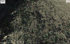
33 25'16.22"N 111 18'10.16"W 1/2018
HEART.jpg What`d it say on the preist map?
 

Last edited:
OP
OP
393stroker

393stroker

Hero Member
Jun 27, 2012
505
789
HOUSTON
Detector(s) used
Garrett pro-something
Primary Interest:
All Treasure Hunting
Well I made it to where I thought I would find the heart shape but I couldn’t see it. Waltz said it’s up high but you have to go down low, and he hid his tools in the saddle. So if he went up from the north side and went over the saddle and down toward the west that’s where the doodle backwards can be seen. There appears to be a dual entrance cave in a rock outcrop there, but when I looked through the binoculars up there it just looked like an overhanging big rock. From the highest point on 4 peaks to this is eighteen miles. From Weavers it’s 100 degrees give or take. I need to get up there and check it out. I found the way up from the west before Whiskey Spring,It’s easy, anybody up to it?
 

Last edited:

dredgernaut

Hero Member
Dec 27, 2012
560
1,444
wisconsin
Detector(s) used
whites mxt, tesoro lobo super trac., monster1000
Primary Interest:
All Treasure Hunting
sorry bud.. i wish i could.. be safe if you go alone..
 

dredgernaut

Hero Member
Dec 27, 2012
560
1,444
wisconsin
Detector(s) used
whites mxt, tesoro lobo super trac., monster1000
Primary Interest:
All Treasure Hunting
i might be back out the end of march or beginning of april.. how many days are you planning to get in and out..
 

markmar

Silver Member
Oct 17, 2012
4,117
6,259
Primary Interest:
All Treasure Hunting
Stroker

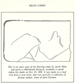
IMHO, the doodle should not be read backwards/reversed. The image from the doodle should be seen from a specific spring and from there someone has to follow other clues in regards to find the LDM. The doodle was drew by Waltz while was telling the German clues to Julia and Reinhard. So goes like this:

"Ein hoher berg steht zu dem osten.”
A high mountain is to the east.

“Ein tiefes tal lieft zu dem wester.”
A deep valley lies to the west.

Schav fur die felsenspitze die Mexicaner benutzten die felsenspitze al sein anhaltspunkt.”
Look for the spire, the Mexicans used the spire as their marker.

“Zu dem westen kannst du den sehen.”
You can see it to the west.
 

Attachments

  • Waltz%20sketch.png
    Waltz%20sketch.png
    27.4 KB · Views: 41
Last edited:
OP
OP
393stroker

393stroker

Hero Member
Jun 27, 2012
505
789
HOUSTON
Detector(s) used
Garrett pro-something
Primary Interest:
All Treasure Hunting
Stroker

IMHO, the doodle should not be read backwards/reversed. The image from the doodle should be seen from a specific spring and from there someone has to follow other clues in regards to find the LDM. The doodle was drew by Waltz while was telling the German clues to Julia and Reinhard. So goes like this:

"Ein hoher berg steht zu dem osten.”
A high mountain is to the east.

“Ein tiefes tal lieft zu dem wester.”
A deep valley lies to the west.

Schav fur die felsenspitze die Mexicaner benutzten die felsenspitze al sein anhaltspunkt.”
Look for the spire, the Mexicans used the spire as their marker.

“Zu dem westen kannst du den sehen.”
You can see it to the west.
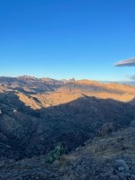
This area is what I think depicts the doodle. It’s not lined up perfectly because I wasn’t all the way up near the top but just on the first step. Everyone has their own opinions and ideas and I’m curious to see if I can come up with something up on Coffee Flat. The hard part is finding the time to make a move on the path forward. I don’t take it so seriously anymore and just try to get some fun out the experience. You should try to make it over here sometime soon and check it out Marius. You won’t regret it. 4035FD2D-4538-4B0D-99A5-5ABDAFDA9CFD.jpeg
 

markmar

Silver Member
Oct 17, 2012
4,117
6,259
Primary Interest:
All Treasure Hunting
This area is what I think depicts the doodle. It’s not lined up perfectly because I wasn’t all the way up near the top but just on the first step. Everyone has their own opinions and ideas and I’m curious to see if I can come up with something up on Coffee Flat. The hard part is finding the time to make a move on the path forward. I don’t take it so seriously anymore and just try to get some fun out the experience. You should try to make it over here sometime soon and check it out Marius. You won’t regret it. View attachment 2066592
Ok. Then I wish you to have a lot of fun out of the trips you will make. Take a good camera because i like to see the LDM region from afar.
 

Ramiro valdez

Full Member
Aug 26, 2020
182
103
San Antonio, Texas
Primary Interest:
All Treasure Hunting
That is a ciphered doodle! The view is from the Sierra mountain range, the reason you don’t get it is because it’s ciphered with a telescope. Here led me add a little more .
 

Ramiro valdez

Full Member
Aug 26, 2020
182
103
San Antonio, Texas
Primary Interest:
All Treasure Hunting
In the 1860’s two soldiers from Fort McDowell actually found some gold pertaining to the Lost Dutchman’s goldmine.They were traveling across the mountain towards the needle in route towards the silver mines. A doctor blindfolded by the Indians claim that the LDM was located near the needle. Adolph Ruth was unsuccessful in obtaining gold but claimed that the goldmine was located somewhere near the needle? The needle can be seen from many miles away and was used by many travelers long before it changed its name to weaver’s needle. The needle was actually drawn on a stone map that Peralta found in the 1840’s. It was used on the map like a pointing needle. They found the needle’s left side extending wall to be the pointer because it point to the location of the goldmine which was located towards the northeast and the sidewall was the clue. Some say that the sunset creates a shadow below the wall that follows the same direction as the wall and it actually looks like the shadow of a moving pointing finger. Figure that! The fact that the stone map uses the needle’s left side wall to point to a location very very far, due to the map being 100 square miles in length, in a northeastern direction as the wall indicates puts this four character’s stories in question as to having found the goldmine. There is no way for this to be true, because according to not one but two stone maps, the Dutchman’s goldmine is located in an area that belongs to the Sierra Ancha mountain range based on two coordinates and seas level position. The needle points to a far away location and because of this it will never point to its surroundings which makes those three claims impossible. All three were not in accordance with the stone map’s directions. Three claims taking the focus away from a real stone map produced by a Jesuit in connection with the Templars who ciphered the map by the used of a compass, navigational coordinates, sea level position and precision. One cannot fault anyone for believing that they have found the LDM based on the information they had and we cannot take away from that because they are dead. But we could learn not to make the same mistake. Do not be fooled by miss information. Sorry Ruth
 

OP
OP
393stroker

393stroker

Hero Member
Jun 27, 2012
505
789
HOUSTON
Detector(s) used
Garrett pro-something
Primary Interest:
All Treasure Hunting
It`s been told that some cowboy named Robles witnessed Waltz going up the canyon on the north side of Coffee Flat Mountain. So why would he waste his efforts to go there if he knew the mine was somewhere else? Maybe it was easier to go up the north side then come down on the south side where there is an area that has a square rock, you can see 4 Peaks and Weavers Needle just like the doodle but backwards. Does anybody know of a way to get up there or a link to some photos from up there. I`m planning on trying to get up there in the future. I want to explore that area and check out the heart shape to see if it`s man made or natural. Who was Robles? =Robe less
Chuck,

View attachment 1743762

This is the canyon Waltz is referred to going up on the North side of Coffee Flat Mountain (near the red number 14). Picacho Peak is the highest point on Coffee Flat.

Yes you can get all the way to the top of Picacho Peak using that canyon but it is very rough, there is no trail and you cannot get horses up it. Someone might be able to get a burro or a mule up there today but would be difficult. I had a mining claim up in that canyon in 1982. The Harnish brothers had blanket claimed the entire lower part of the canyon and down into LaBarge. The canyon is known to old timers as Coffee Flat canyon.

To my knowledge Gabriel Robles, a cowboy from the Florence AZ area told this story about Waltz. He got the story from his father, also a cowboy, who allegedly knew Waltz. Gabriel Robles was one of the men who searched for the missing Adolph Ruth with Tex Barkley and Jeff Adams.

Matthew
These guys went up the same way I did last time out there. I followed some deer but didn’t go all the way up.
 

Top Member Reactions

Users who are viewing this thread

Top