Dowsing a False Color Satellite Image Map for the LAD placer gold

RBrown

Jr. Member
Oct 10, 2012
26
1
Phoenix Arizona
Detector(s) used
Minelab
Primary Interest:
All Treasure Hunting
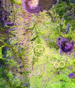
I have a false color satellite image of a large alteration zone that I believe is where the Lost Adams Diggings is located. The image parameters were validated using the Ortiz and Vulture mine fields. The main alteration zone is 15 miles long and the erosion area is almost two miles wide so that's 30 square miles that need to be searched in a very remote and desolate area.

In the accompanying picture the alteration zone is the long white vertical streak just to the left of the center of the image. The erosion areas are shown in pink.

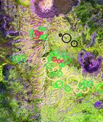
I would like help in determining if there are any gold deposits (lode or placer) in this map area. If so I have much more detailed maps and images available (down to 6" resolution) of the 15 mile by 20 mile area shown in the attached map which could be used to narrow down the search area considerably.

I would like to hire someone who is good at map dowsing to help me in this effort. I am retired (otherwise I wouldn't have all the time it takes to develop these false color mineral maps) so I don't have a lot of money to work with.

Aster_LAD_Alter_Zones_6.jpg
 

aarthrj3811

Gold Member
Apr 1, 2004
9,256
1,169
Northern Nevada
Detector(s) used
Dowsing Rods and a Ranger Tell Examiner
Hey RBrown...I don’t find the LAD on your map..I found a long gold vein that is exposed to the surface at the top of the red line..Hope this helps...Art

Aster_LAD_Alter_Zones_6.jpg
 

Red_desert

Gold Member
Feb 21, 2008
6,852
3,504
Midwest USA
Detector(s) used
Garrett Ace 250/GTA 1,000; Fisher Gold Bug-2; Gemini-3; Unique Design L-Rods
Primary Interest:
All Treasure Hunting
This must be a different Lost Adams diggings, that I researched out years ago.....it was in NM and story narrows down to a small box shaped canyon.
 

Red_desert

Gold Member
Feb 21, 2008
6,852
3,504
Midwest USA
Detector(s) used
Garrett Ace 250/GTA 1,000; Fisher Gold Bug-2; Gemini-3; Unique Design L-Rods
Primary Interest:
All Treasure Hunting
Got some nice signals at the yellow circles, especially the largest with 2 smaller inside it.
 

Attachments

  • Aster_LAD_Alter_Zones_6=RBrown.jpg
    Aster_LAD_Alter_Zones_6=RBrown.jpg
    167.4 KB · Views: 270
OP
OP
RBrown

RBrown

Jr. Member
Oct 10, 2012
26
1
Phoenix Arizona
Detector(s) used
Minelab
Primary Interest:
All Treasure Hunting
aarthrj3811 - I see a lot of red lines in the image you put up but I don't understand what you mean by there is a long gold vein at the top of the red line? Does this mean there is a gold deposit around the top red box you drew, or did you mean something else?

Red desert - Yes you are correct this is in New Mexico and this canyon ends in a three mile long box canyon with very steep walls about 800' high. At the entrance to the box canyon there is a 82' deep water channel with logs jammed in. The main canyon is 1000' across and the bottom is flat with no trees growing but along the sides of the ridges are covered with small pigmy pine trees (no more thn 12' tall). There is a spring that flows all year there and the land on the SW side of the canyon is much darker then the land on the NE side of the canyon and the water flows to the NW. The average elevation is 7400'. The Allen Account (page 25 of The Lost Adams Diggings by Jack Percell) is a perfect match for this canyon. I found every thing mentioned in the Allen Account except the cabin.

Unlike everyone else I didn't try to find the LAD by going by the stories description of the way the traveled to or from the LAD but instead I decided to look for alteration zones (which is where the lode deposit was located and the LAD's placers came from). I narrowed the 30,000 square mile search area to 1000 square miles by drawing a 30 mile radius around the Aspen stand found by Dick french and looked for all the alterations zones in that area. I only found one. The one in the picture I attached above. Dick also sent me a copy, of his personal copy, (this story has not been published in any of the Adams material) of a story from Adams death bed where he said the gold was in a sandy area where the water didn't flow out of. So I am looking for a sandy area with no discernible geological features.

Any help would be appreciated.

Roger
 

OP
OP
RBrown

RBrown

Jr. Member
Oct 10, 2012
26
1
Phoenix Arizona
Detector(s) used
Minelab
Primary Interest:
All Treasure Hunting
aarthrj3811 - Thanks for explaining your finding.

I checked this entire area (actually twice the area in the map I attached above) for surface gold and found no reflections. Gold is extremely reflective in the IR and there were no emissions anywhere in this entire area. Additionally, gold exhibits self emission above 10 um and is easily identified this way and there were none shown anywhere in this entire area. I ran the algorithm assuming any surface gold would be covered with a dust costing which cut the emission down to under 3% and still there were no indications of surface gold. I did get surface emission of quartz mixed with background rock but no metallic content.

I ran complete scans for the seven minerals related to lode gold deposits and did not find any in the area you set out. While that doesn't mean there isn't any gold in the area you set out the likelyhood of your area being the LAD is not very good as there is no alteration zone near the area you marked and lode gold can only form in an alteration zone and placers can only occur in the erosion areas below an alteration zone. As these two key parts are missing in your area that means there could be a subsurface gold deposit but it can't be the LAD as there is no erosion area in the area you marked.

I appreciate your help and effort but you seem to have found a different gold deposit then i was looking for. The area is so remote and desolate that mining a lode deposit is out of the question while a rich placer deposit would be doable, at least in part. The first time I was there I blew out the sidewalls in both my rear tires (I have a specially equipped Ford Explorer set up for off roading). There is nothing within 70 miles of this place and I had to drive 70 miles to get where I could get some help. It cost over $1000 and then I still had another 350 miles to drive home. There is no cell service within 50 miles of the area and not even police radios can get reception in that area.

Roger
 

aarthrj3811

Gold Member
Apr 1, 2004
9,256
1,169
Northern Nevada
Detector(s) used
Dowsing Rods and a Ranger Tell Examiner
Hey Roger..There would be gold float from the exposed part of the gold vein working its way downhill...The only difference between Placer gold and float gold is it has not been in a stream being smoothed and pounded.... Aster_LAD_Alter_Zones_6.jpg
Just something to think about..Art
 

Last edited:
OP
OP
RBrown

RBrown

Jr. Member
Oct 10, 2012
26
1
Phoenix Arizona
Detector(s) used
Minelab
Primary Interest:
All Treasure Hunting
:icon_thumleft:aarthrj3811 - You may have a point there with float gold. This is what happened in the Carlin field in Nevada. While its not possible for a quartz vein lode gold deposit to form outside of an alteration zone and then they only form around the periphery of the alteration zone (az). However, in the center of the az, which is where the liquid materials first blow through (like a volcano exploding) because the pressure is so high and this location (the central part of an az) has the largest cracks and fissures. The material is blown way up in the air, could be miles high, if there is gold mineralization in the liquid then the gold solidifies into mieron size droplets and slowly falls down to the ground as micron gold. The area of the micron gold will indicate how high the eruption went. In the Carlin event it is thought that the blast went several miles high and the total field was produced by several (instead of one) events. Now, when I say eruption I don't mean fire and lave like a volcano but a blast like a big steam vent opening blowing 1000+ F water and minerals high into the air. As the central part of the az solidifies the remaining high temperature and pressure liquid looks for other routes of escape which are the areas next to the large fissures in the central part of the az. This way an az grows in width much the same as a volcano only using steam instead of lave.

Thanks for your great work and detailed maps. The area you found is extremely hard to reach but maybe I could get to it this spring or summer and take soil samples and test for micron gold. But my present problem is where is the LAD placer deposit.

Roger
 

aarthrj3811

Gold Member
Apr 1, 2004
9,256
1,169
Northern Nevada
Detector(s) used
Dowsing Rods and a Ranger Tell Examiner
This book was the most important to my prospecting,,, Tertiary Gravels of the Sierra Nevada of California by Waldemar Lindgren’s..this book was written in
Tertiary Gravels of the Sierra Nevada of California - Google Search
I have found gold veins in all kinds of rock...Quartz is a good sign but not the only one...The present of “tuff” is also a good sign ....Tuff is volcanic ash that has turned into clay..I get excited every time I find blue clay...Green Rock is another clue...Mother earths crust is granite so that gold had to flow though it..
Gold is where you find it and always will be....

Since I moved to the high desert I find my Jeep is not a good way to move around...I use horses or trail bikes..I look at the maps and try to find sand washes that I can connect...Art
 

Last edited:
OP
OP
RBrown

RBrown

Jr. Member
Oct 10, 2012
26
1
Phoenix Arizona
Detector(s) used
Minelab
Primary Interest:
All Treasure Hunting
aarthrj3811 - I am not a prospector and don't know what to look for but Adams said repeatedly that "no geologists will ever find my mine". This has been thought to mean there are no standard geological signs in the area. The area I found using the satellie images had three BLM paid geology survey teams check out the entire area. This was in the early 1960's and then in the early amd mid 1980's. All three reports stated there is no worthwhile mineralization in the area. this didn't surprise me after I went there. There is no color, tuff or anything else other than brown rock and brown sand. No color anywhere except some green trees on the sides of the canyon.

From the old Adams' stories I don't think having extensive geology and prospecting knowledge and experience will be of any use. As this is the only alteration zone within 30 miles of the Aster stand and the fact that the box canyon perfectly matches the Allen description I think this is right place. The only problem is the search area is 30 square miles (the placer deposit will be located in the pink erosion area which is 15 miles long and two miles wide). I need to greatly narrow down the search area as taking a sample every 50' in such a large area will take years and cost more money than I have. I am retired living on SS now.

Take care, and thanks for all the kind help.

Roger
 

OP
OP
RBrown

RBrown

Jr. Member
Oct 10, 2012
26
1
Phoenix Arizona
Detector(s) used
Minelab
Primary Interest:
All Treasure Hunting
okiedowser - Are the two solid red circles you drew two mine/cave shafts, or are they something else?

I assume the two connecting red lines (with arrow tips) part of the cave system or are they just text identifiers and are not associated with the two solid red circles?

Thanks for all your help in looking over my map.

Roger
 

okiedowser

Hero Member
Dec 26, 2009
625
376
Mena,Ar
Primary Interest:
All Treasure Hunting
Red Dot is where the seal cave's are,text identifier....... the yellow line is the Gold Vein.
 

OP
OP
RBrown

RBrown

Jr. Member
Oct 10, 2012
26
1
Phoenix Arizona
Detector(s) used
Minelab
Primary Interest:
All Treasure Hunting
okiedowser - What is a "seal cave"? In your drawing you call it a "cave seal" does that mean its a cave but its sealed up or is it something else?

What is a gold pocket - no vein (from your picture)? Is this a lode gold deposit, or something else?

Sorry for being so stupid.

Thanks for your help.

Roger
 

okiedowser

Hero Member
Dec 26, 2009
625
376
Mena,Ar
Primary Interest:
All Treasure Hunting
A seal cave,is where a person cover it up,where they can find it but no one else,most likely there marking's on rock's to to mark the way back to it....a gold pocket is where gold is pooled up in one spot,sometime several oz's. i just know this is in one spot, could be a gold cache,being so far back in there, most likely a gold deposit in a pocket.
 

Red_desert

Gold Member
Feb 21, 2008
6,852
3,504
Midwest USA
Detector(s) used
Garrett Ace 250/GTA 1,000; Fisher Gold Bug-2; Gemini-3; Unique Design L-Rods
Primary Interest:
All Treasure Hunting
Did a search for archaeological type, marked in green, doesn't depend on gold being present.....but can also locate Native American artifacts. Red for possible caves/tunnels or old diggings. Ignore the black, is only geological.
 

Attachments

  • Aster_LAD_Alter_ZonesB_6=RBrown.jpg
    Aster_LAD_Alter_ZonesB_6=RBrown.jpg
    168.4 KB · Views: 238
OP
OP
RBrown

RBrown

Jr. Member
Oct 10, 2012
26
1
Phoenix Arizona
Detector(s) used
Minelab
Primary Interest:
All Treasure Hunting
Red desert - I would expect there to be a lot of Native American artifacts present as the Indians (it isn't clear which tribe but the best guesses are Apache and/or Navajo) killed most of the Adams party except for Adams and two people in a gun battle. For a while the Indians had a camp near the box end canyon.

What is the difference between a large Red circle and a small Red circle (is it the intensity of the hit or something else)?

What do you mean by the Black circles are geological?

This new map has a much different distribution of circles, with a cluster at the top and one near the middle, than did your first map which had just a few Yellow circles near the middle of the map. Is this because you dowsed for something else this time or you did something differently, or what?

Please excuse me for being so stupid but I don't know anything at all about map dowsing except that it is suppose to work. I have tried to do it on several occasions but couldn't even find my house on a picture of it. Several years ago I went to Sedona Arizona (home of a lot of professional psychics) and paid several (at different times) to teach me how to map dowse. After a few minutes each of them told me that I had a block and they wouldn't be able to teach me how to map dowse.

I will have to figure out the coordinates of your circles and check them out when I go the area this spring.

Roger
 

Red_desert

Gold Member
Feb 21, 2008
6,852
3,504
Midwest USA
Detector(s) used
Garrett Ace 250/GTA 1,000; Fisher Gold Bug-2; Gemini-3; Unique Design L-Rods
Primary Interest:
All Treasure Hunting
First map, yellow circles were only a search for raw gold. Black circles definitely not related to the diggings....started out checking for crude oil, still not sure what I'd found. Larger red circle in an area were first, sometimes smaller is a more defined hit when next to or inside the larger ones. Green for archaeological, added just to identify old sites. Red circles in this dowsing, could be an indication (with or without any treasure) of a cave, tunnel entrance or old mine.....but could be diggings also. Larger circles also can represent, signals spread out covering a much larger area of land.
 

johnu33301

Jr. Member
Jan 21, 2013
33
0
Primary Interest:
All Treasure Hunting
This is very interesting RBrown!! I would be interested in taking some IR ground picks of the area that everyone Dowsed with my Canon!! Also your statement "Gold is extremely reflective in the IR and there were no emissions anywhere in this entire area. Additionally, gold exhibits self emission above 10 um and is easily identified this way and there were none shown anywhere in this entire area. I ran the algorithm assuming any surface gold would be covered with a dust costing which cut the emission down to under 3% and still there were no indications of surface gold. What are you using to look for emissions?
 

OP
OP
RBrown

RBrown

Jr. Member
Oct 10, 2012
26
1
Phoenix Arizona
Detector(s) used
Minelab
Primary Interest:
All Treasure Hunting
For looking for raw surface gold I can use either the Aster or Landsat 7 satellites. The Aster series has 15 different light sensors. For mineral detection/location the Aster series is superior to the Landsat series, for most mineral mapping, because its sensors have a much smaller bandwidth.

Band No. Spectral Range (μm)
1 0.52-0.60 visible range
2 0.63-0.69
3N 0.78-0.86
3B 0.78-0.86
4 1.60-1.70 Near IR range (reflected light)
5 2.145-2.185
6 2.185-2.225
7 2.235-2.285
8 2.295-2.365
9 2.360-2.430
10 8.125-8.475 Extended IR range (from self emission - absorbed heat)
11 8.475-8.825
12 8.925-9.275
13 10.25-10.95
14 10.95-11.65

While the Landsat satellite system also has IR sensore they don't go as far into the IR as do the Aster series satellites. But the Landsat system has higher resolution than the Aster series does but the images are over a gigabyte in size. The 3B sensor is a back looking sensor used to provide 3D views in the visible spectrum.

You can find more about these sensors at this link: http://asterweb.jpl.nasa.gov/content/03_data/04_Documents/aster_user_guide_v2.pdf

It takes several hours to find a suitable image that doesn't have any clouds in it and then translate and combine the package into a multi-layered image. Then after all this is finished the algorithm can be run in a few minutes (if you have a very fast multi-processor computer).

As far as gold emission goes there are very detailed wavelength tables for gold in the "Handbook of Chemistry and Physics". When you build your algorithm you need to take into consideration the fact that gold laying on the ground does not have a highly polished surface (which exhibits highly directional reflection) but instead the surface is pitted and generally coated with a clear varnish (from being exposed to the elements for years - this coating is so bad when I drop a gold placer into a fresh batch of aqua-rega nothing happened because the acid couldn't get to the gold surface). This pitting usually makes the gold placers/flakes reflect light in a unidirectional directional (failry evenly with angle). Generally a placer will exhibit less than 20% reflection and one that has a thin dust coating under 5%.

An algorithm to find such materials looks for similar emissions/reflections withing 2% between the various bands down to 1 um where the reflection starts to drop (refer to the Handbook of Chemistry and Physics). The reflection of gold continues to drop somewhat evenly across the visible spectrum so the algorithm also looks for the drop ratio between bands 4, 3N, 2, and 1. Such an algorithm is very comples and requires many steps and resulting images.

Another way to build your algorithm is to select four bands and produce maps from the rations of the three products. For this type of algorithm you would divide three IR bands by the lowest visible band (which would be band 1). For this type of algorithm you would use the Landsat satellite system as the Aster series does not have a blue sensor like the Lamdsat does. The ration of the reflectivity for gold between blue light and any of the IR bands is very high. So if you used the Landsat series you would produce an image from the division of band 7 and band 1 (ie: 7/1). Then produce a second image from bands 5 and 1, and a third image from bands 4 and 1. Then assemble these three layers into a single image and assign the 7/1 band as the Red layer, the 5/1 as the Green layer, and the 4/1 image as the Blue layer of the new image. Then the resulting false color image, which will be devoid of most of the topological information, will show surface gold as white dots.

You need to be careful when you analyze these images for you can get white dots over habitated areas (mostly from the trash and junk in peoples yards) but this is generally not a problem in open areas where people don't live or trash.

These images are quite large, generally 300 megs per layer. The division usually requires 30 billion division calculations per layer or over 100 billion calculations to produce a false color image.

If you want to a simple introduction to false color satellite mineral maps start with this link: Satellite Mineral Images

The gold reflectance algorithm is an extremely simple one that doesn't require and research or testing. Algorithms to find mineral fields are far more difficult to develop.

Another word of caution these satellites can't see anything smaller than 30' so you are looking for an outcropping of a thick vein lode gold deposit they will never see it however they will see the alteration zone where the deposit was formed, so in this case you would not look for gold at all but rather an alteration zone. For micron gold you use yet another different algorithm.

I hope this answered your question.

Roger
 

Top Member Reactions

Users who are viewing this thread

Top