teleprospector
Silver Member
- Jul 8, 2007
- 3,794
- 4,134
- 🏆 Honorable Mentions:
- 25
- Detector(s) used
-
Extended Sensory Perception, L-rod, Y-rod, pendulum, angle rods, wand.
White's MXT, Garrett Ultra GTA 500, AT Gold, SCUBA Detector Pro Headhunter, Tesoro Sidewinder, Stingray, 2 box-TF900, Fisher TW-6
- Primary Interest:
- All Treasure Hunting
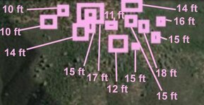
"adjacent gulley is a very old iron pipe the crosses the gulley about 10 feet in the air, and goes into the earth on both sides."
That's interesting! The reason it caught my attention, probably doesn't apply here, but in Europe a pipe going straight down into the ground could indicate a bunker. Recently, about 3-4 months ago, I was looking through the pics taken by people exploring an old Nazi bunker they had found. From the surface, the only visible clue was these pipes sticking up out of the ground and that must have been to get air down into the bunker. Of course, the ends on these pipes were curved, making them look more like an exhaust pipe of an automobile.
Hmmm....maybe Hosssauce's site is where they filmed some of the Hogan's Hero's episodes?


")