AmericanCoinHunting
Bronze Member
- Apr 23, 2005
- 1,062
- 6
- Detector(s) used
- E-Trac w/Pro Coil,and 6x8" S.E.F,The Relic & Gold hunters DREAM...a Troy X-3 w/3 coils
- Primary Interest:
- All Treasure Hunting
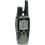
") Most of us men would rather use memory,or a map,rather than let a little female voice tell us where to go. But I am not talking about the car attatched "Tom-Tom",or "Garvin" on the dashboard. I am talking ---Handheld GPS--
Most of us men would rather use memory,or a map,rather than let a little female voice tell us where to go. But I am not talking about the car attatched "Tom-Tom",or "Garvin" on the dashboard. I am talking ---Handheld GPS--.......................Is anyone familiar with handheld GPS? Can you use it to locate a site you have researched on an old map ?
Can you mark location of your latest find ? Or Mark (In an unfamiliar site )the location of where you left your vehicle so you can find your way back .?..LOL,,,I know I would not want to admit it but if I had a GPS.....That is one thing I would use it for LOL.
Lastly.........Since I am an (Older Soldier... .....quite familiar with the Map & Compass )But very unfamiliar with the handheld GPS.
I am doing the research this winter about Handheld GPS,and would like to use it for the things I mentioned above.
I could probably give up as much as $400-$500.......To own one,but I don't want to have to pay a subscription fee,nor would I want to have to buy a (Software---set of Maps) I would like it self contained with a set of maps,2008 or newer,that I could { Don't TELL my Wife},,,use to drive by as well.
Any ideas / I am sure I will have more questions ,as soon as some of these are answered.
Thanks for any HELP....