Help with Historic Aerials Symbols

Dirt Fisherman

Greenie
Apr 2, 2015
12
6
Arcata, CA
Detector(s) used
Bounty Hunter Sharpshooter II
Primary Interest:
Metal Detecting
Hi everyone. I am looking at a topo map from Historic Aerials and have a question about some of the symbols. In the middle of the picture here there is the triangle, the three lines under it and a block square or dot at the tip of it. Does anyone know what those symbols mean? I know there is a USGS marker in the woods around there so one of the symbols may stand for that. Does the black dot/square look like a building to you guys? I have found some old shotgun shells, and some old rusted cans there on a brief walk with the detector but am wondering if a house used to be there and it would be worth going back and detecting again. Any ideas would be helpful.

View attachment Topo.pdf View attachment Topo3.pdf View attachment TopoZoom.pdf

Thanks,
Dirt Fisherman
 

Mackaydon

Gold Member
Oct 26, 2004
24,118
22,894
N. San Diego Pic of my 2 best 'finds'; son & g/son
🏆 Honorable Mentions:
2
Detector(s) used
Minelab Explorer
Primary Interest:
Shipwrecks
The triangle with a dot is called a 'spot elevation' mark, designating the highest point on a mountain or hill. The black dots are structures that would normally be occupied. The 'hollow' mark rectangles designate structures that would normally not be occupied--like greenhouses, barns, garages, etc.
Don......
PS: Welcome to Treasure Net !!
 

Last edited:
OP
OP
D

Dirt Fisherman

Greenie
Apr 2, 2015
12
6
Arcata, CA
Detector(s) used
Bounty Hunter Sharpshooter II
Primary Interest:
Metal Detecting
Great thank you for the information. I was also curious about the hollow vs black rectangles. I did some more research and the black circle at the point of the triangle may be a water tank, which also makes sense as there is an old water line shutoff in the middle of the woods there. The road leading to that spot no longer exists which is what piqued my curiosity. I guess I'll have to go back with my detector and see what I can find.
 

Charlie P. (NY)

Gold Member
Feb 3, 2006
13,004
17,108
South Central Upstate NY in the foothills of the h
Detector(s) used
Minelab Musketeer Advantage Pro w/8" & 10" DD coils/Fisher F75se(Upgraded to LTD2) w/11" DD, 6.5" concentric & 9.5" NEL Sharpshooter DD coils/Sunray FX-1 Probe & F-Point/Black Widows/Rattler headphone
Primary Interest:
Metal Detecting
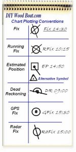
A triangle and dot is also used to indicate an estimated position when charting your position.

ChartPlottingSymbols.jpg
 

Top Member Reactions

Users who are viewing this thread

Top