Digital Prospecting working out!

CApicker

Full Member
Nov 3, 2013
153
260
West Sacramento, CA
Primary Interest:
All Treasure Hunting
April Gold MFA.jpg
Digital Prospecting...
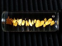
The old statement "it's not about having the Gold it's about finding it" holds true for me. I have been using a resource lately that has improved my Treasure hunting abilities by allowing me to superimpose different layers of maps over each other. CalTopo.com is a fantastic site; I have been layering maps from as far back as 1885 with current river maps to reveal the position of the river years ago. This picture is from about 8 average pans in one location along the American Rivers in the California Motherload. :thumbsup:
 

Upvote 0

Cariboo5

Hero Member
Oct 27, 2011
725
1,154
Primary Interest:
All Treasure Hunting
Excellent idea....:thumbsup:......thanks for sharing
 

goldenIrishman

Silver Member
Feb 28, 2013
3,465
6,152
Golden Valley Arid-Zona
Detector(s) used
Fisher / Gold Bug AND the MK-VII eyeballs
Primary Interest:
Other
Yup! Computers have made finding good places to dig for gold a lot easier. With many sources that in the old days you'd have had to travel 100s of miles to access now being on-line, there's no excuse for not putting them to work for you.
 

Frghtshkr

Full Member
Apr 23, 2013
100
41
Gilbert AZ
Detector(s) used
Gold Cube, Royal Mini Highbanker, Angus Mackirk sluice
Primary Interest:
Prospecting
I wish I could figure it out. Hell Google Map is about it for me.
 

Duckwalk

Hero Member
Mar 21, 2014
966
1,312
Lincolnton North Carolina
Detector(s) used
30" Bazooka Sniper, Drop Riffle sluice box.
Various Gold Pans
Primary Interest:
Prospecting
I have not done it with prospecting but ive done some school projects (about 10 years ago....) in highschool layering terrain. I used these transparency papers. used for like over head projectors. you can print straight from your printer. If it can do elevation, im sure you can just print regular maps on them and layer accordingly.

Apollo Quick Dry Universal Ink Jet Printer Film, Color, 50 Sheets
 

OP
OP
C

CApicker

Full Member
Nov 3, 2013
153
260
West Sacramento, CA
Primary Interest:
All Treasure Hunting
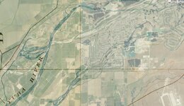
Yes a little hard to use but worth trying to figure out. Use the toolbar at the top right to choose and slide between layer density. Here is an example of the Yuba Gold Fields in Marysville CA. This is a 50% dissolve between current satellite photos and a map of the river from 1885. The darker Blue is the old river path...
Yuba Gold Pools.JPG
 

matthews1026

Jr. Member
Jan 1, 2013
63
33
Elverta, CA
Thanks for this...This explains a few things that I have seen while out prospecting....like why is there river rock up that side of the hill, I knew that the river has changed but now I know how and where.
 

goldenIrishman

Silver Member
Feb 28, 2013
3,465
6,152
Golden Valley Arid-Zona
Detector(s) used
Fisher / Gold Bug AND the MK-VII eyeballs
Primary Interest:
Other
It's not only for images that computers are great. I'm not sure about other states but here in Arizona the state geological service has a great site that is just chock full of mine records that you can either view on-line with a PDF plugin for your browser or download for FREE!!! Mining Collections | Arizona Geological Survey Mining Data They have things ranging form assay reports to tunnel maps and lots of old pictures from 1910 forward.

Also... The USGS site has downloadable topo maps for free. Haven't checked any other states but every topo map for Arizona is available for download as a ZIP file. Even zipped they're some pretty hefty files.

There is another on-line resource fixing to open its doors to the public that I was asked to help beta test. I can't post the address here just yet but I can tell you that this will be a "go to site" for just about every miner in the western United States. Claim maps, e-books, maps, laws etc are all going to be covered and covered well. Soon as I'm given the go ahead I'll post the link to it.
 

azblackbird

Sr. Member
Sep 27, 2011
259
312
Glendale, AZ
Detector(s) used
TDI Pro, GMT
Primary Interest:
Prospecting
It's not only for images that computers are great. I'm not sure about other states but here in Arizona the state geological service has a great site that is just chock full of mine records
Yep… I found that site a couple years ago. I started pulling data directly from their servers just as fast as they could load it. It's pretty nice now that they finally put an interface to it. :thumbsup:
 

goldenIrishman

Silver Member
Feb 28, 2013
3,465
6,152
Golden Valley Arid-Zona
Detector(s) used
Fisher / Gold Bug AND the MK-VII eyeballs
Primary Interest:
Other
Yeah the interface is very nice. It's easy to use and allows for searches that you can define the parameters of so you don't get a bunch of returns that you either didn't want or didn't need. i've been working on download all of the records for Mohave County and it's a daunting task just because of the shear number of files. I've still got about 50-60 mines to get and the set will be complete. That they chose PDF as the format for saving the data in was not a wise choice though. There are other formats that would have kept the file size much smaller.

Having looked at how they've got the files setup on the server, it could have been done in a more orderly manner that would make downloading via FTP possible. With all the data I'm getting from them I could have had Mohave County finished up already. What can I say? Sometimes the "old School" way IS a better choice.
 

Top Member Reactions

Users who are viewing this thread

Top