Check this property map out, give me your thoughts Please!

jvan

Full Member
Sep 30, 2014
149
201
Placerville, CA
Detector(s) used
Gold Hog Raptor Highbanker, Fisher Gold Bug 2, Fisher F70, Bazooka 36" Sniper, Gold Cube, Gold Vac Pac, Pans & Pans
Primary Interest:
Prospecting
So I live on the somerset/placerville boarder, my property backs up to the cosumnes river, about 2 miles from E16...

(A SPOT on Image)
So I just went down there for the past 2 weekends with my bazooka gold trap, and ran about 10 buckets from the sand bar and from random holes and pockets in the river, I was able to dig down about 3 feet, with total depth wearing my waders was about 5 feet... Not a single color, no flour nothing... So that was all within the cosumnes river.


I would think there is gold around here, because reading about Bucks Bar Road history there was mining camps posted up all within a mile of my land.....

(B Spot on Image)
Anyhow the 45 min hike down I always noticed like steep old river beds or something as it is deep dry trail....

My understanding is ancient rivers run North/South and modern rivers East/West. This old river clearing is running N to S , So not sure if stumbled on something there or not.

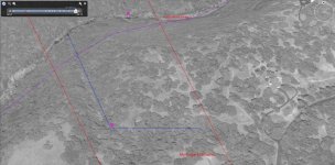
So anyhow I decided to check out Google Earth this evening and noticed you can clearly see what looks to be a ancient river, The photos below show (RED) my property lines, (BLUE) what looks to me to being a ancient river...

What I was thinking to do is try digging deep where the water would of came down and kinda to the the sharp right turn, this is the best I can tell where the flow of the water went...( B SPOT IMAGE)

The trench looks to be about 10 feet wide currently and has large trees growing in the middle of some of the area so looks to be very old...

Anyhow care to comment? any advice as I am new to all this prospecting, But I am very addicted now and just bought the Gold Bug 2 detector....

Is it worth it? do you think I would have to dig too deep to see anything???

Thanks a bunch.
 

Attachments

  • placerville2.jpg
    placerville2.jpg
    76.3 KB · Views: 184
Last edited:
Upvote 0
OP
OP
jvan

jvan

Full Member
Sep 30, 2014
149
201
Placerville, CA
Detector(s) used
Gold Hog Raptor Highbanker, Fisher Gold Bug 2, Fisher F70, Bazooka 36" Sniper, Gold Cube, Gold Vac Pac, Pans & Pans
Primary Interest:
Prospecting
Can I say Thread hi-jack? You should remove your comment and post your own thread..


Guys, I'm new to this topic but am very much interested to learn.

I have a cousin from Canada (half-half) who is interested in treasure hunting in the Philippines.
Can anybody just dig for treasure in the Philippines? Anywhere in the country?
What does the person need to do or have or prepare for to be able to do treasure hunting in the Philippines?
Does he need to be licensed of some sort or does the actual digger have to be a "licensed digger"?

I appreciate any and all answers in the quickest time possible. Thank you!
 

azblackbird

Sr. Member
Sep 27, 2011
259
312
Glendale, AZ
Detector(s) used
TDI Pro, GMT
Primary Interest:
Prospecting
Is it worth it? do you think I would have to dig too deep to see anything
You need to contact some of the dowsers on this board and let them dowse your photos and they will tell you exactly where the gold is… guaranteed!
 

GoldpannerDave

Bronze Member
Apr 17, 2014
1,076
1,279
Colorado Springs, CO
Detector(s) used
Bazooka 48" Miner and 30" Sniper, Le Trap, Wolf Trap, A52, 2" dredge, Miller tables, Blue Bowl, wheel, Falcon MD20, old White's detector
Primary Interest:
Prospecting
OP
OP
jvan

jvan

Full Member
Sep 30, 2014
149
201
Placerville, CA
Detector(s) used
Gold Hog Raptor Highbanker, Fisher Gold Bug 2, Fisher F70, Bazooka 36" Sniper, Gold Cube, Gold Vac Pac, Pans & Pans
Primary Interest:
Prospecting
The land is private with my home on it, but yes I know what you mean as far as if I do find some I need to claim the mineral rights as well.
 

IMPDLN

Full Member
Mar 18, 2014
218
431
Central Arizona
Detector(s) used
Minelab SD2100 V-2, Gold Bug SE, SDC2300, GPX4500
Primary Interest:
Prospecting
1st of all, private property and mineral rights is a tricky subject that I won't go into. The fact is somebody else may still have mineral rights to that property, other than the land owner so research is in order.

Now down to the possibility of an ancient river there. Not that it isn't possible but I doubt it for a couple reasons. Most ancient rivers are buried with no noticeable surface indications. They tend to show up out of seemingly nowhere like road cuts or where a current day river cuts through the old channel. My other thought is looking at your map it seems to be a terribly straight line. Straight lines are not that common in nature. I believe what you might have there is either an old cut done by miners long ago, or more likely a fault line. I would check USGS maps that show faults in your area and you may find the answer to this question. It could just be a fold from the mountain building process as well. No matter what it is, taking some samples certainly couldn't hurt. You never know what you might find until you take samples.

Certainly there is gold in the area. Don't get frustrated. When you are digging along the river, sand bars aren't the best place to look. Better to find bedrock and drop zones. Gravel bars are certainly better than sand bars. Do some more research on how gold acts in a river system. Areas along inside bends and places where the river goes from narrow to wide or where the gradient levels out and the water slows are all good places to look. Sample areas as opposed to digging willy nilly. In time you will discover gold, given you work smart and keep trying. Sample, sample, sample, and sample some more. Dennis
 

Hoser John

Gold Member
Mar 22, 2003
5,854
6,721
Redding,Calif.
Primary Interest:
All Treasure Hunting
Simply go to the new Pioneer mining store in Auburn and purchase Franks colorized map showing the exact locations of the old ancient river from north to south and MUCH will be revealed. He blew up and colorized a state map to show much more detail. Consumes is spotty for sure,quite a bit of slick bedrock above hi way 49 that doesn't catch gold worth a darn. Associate lived above 5 miles or so from 49 and he/we mined/detected and got fines yuck-John
 

Goldwasher

Gold Member
May 26, 2009
6,077
13,225
Sailor Flat, Ca.
🥇 Banner finds
1
Detector(s) used
SDC2300, Gold Bug 2 Burlap, fish oil, .35 gallons of water per minute.
Primary Interest:
All Treasure Hunting
Your in a good spot promise your just gonna have to poke around a bit until the gold starts to show its local characteristics. you have tertiary river channels in the area but, they are out towards the national forest more. Keep in mind there is a difference between a bench deposit like you may see in your picture and an anchient river channel. There is a ton of decomposed granite in the Consumnes so that sand bar is most likely gravel with sand on top. There are good spots between Bucks Bar and 49. Access is a really good thing to have.
 

Reed Lukens

Silver Member
Jan 1, 2013
2,653
5,418
Congres, AZ/ former California Outlawed Gold Miner
Detector(s) used
Tesoro Vaquero, Whites MXT, Vsat, GMT, 5900Di Pro, Minelab GPX 5000, GPXtreme, 2200SD, Excalibur 1000!
Primary Interest:
All Treasure Hunting
Make sure you have the mineral rights and then if you can get a tractor down, do some sampling at the river. I would run a test at the east and west boundaries to start.
 

Top Member Reactions

Users who are viewing this thread

Top