Aliquot location on irregular section

spillercanyon

Sr. Member
Jan 4, 2012
269
466
California
Primary Interest:
Prospecting
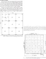
I am looking at staking a claim on a section of land that has an irregular section (for curvature of the earth reasons), can I still use aliquot coordinates to describe my claim or will I have to use distances from some geologic feature? Using aliquot map coordinates, the acreage would be beyond the 20 acres per person on the claim. Is there an easy way to work around this issue?
 

Upvote 0

fowledup

Silver Member
Jul 21, 2013
2,757
5,162
Northern California
Detector(s) used
Whites GMT V/SAT
Primary Interest:
Prospecting
You can still use Aliquot part, the designated descriptions of a section don't change. So even though it may be of an irregular shape the rest of the sections descriptive locators are still there and still apply. I personally do both.
 

Hoser John

Gold Member
Mar 22, 2003
5,854
6,721
Redding,Calif.
Primary Interest:
All Treasure Hunting
On irregular sections you must first examine the section corners(some lines also) 7.5 minute map the best,for a cross designating a USGS bronze/brass marker from where all measurements orginate within the designated section. USGS website has this same explaination almost verbatim. BLM website also has the same same info and much more in free BLM manual on Claiming Public Lands-John
 

Last edited:

Clay Diggins

Silver Member
Nov 14, 2010
4,885
14,258
The Great Southwest
Primary Interest:
Prospecting
You can ignore the above, there is no such system of putting irregular portions at the bottom of a section. More often they are found on the north or the west side.

From your question you want to claim on a Lot or Aliquot that exceeds 40 acres? Since you can only claim 20 acres each you can't take the whole quarter quarter with only two claimants?

It would be helpful if you could distinguish between a non-segregating Lot and a segregating Lot but for the purposes of this general discussion both can be treated the same way.

Irregular sections are the norm in most of California so your question is an important one. First you need to understand that the law requires you describe your claim by aliquot part if possible. There is no legal requirement that your claim exactly fits a surveyed part - you only need to describe which aliquot parts (or Lots) your claim can be found in if there is a survey in place.

Let's say your Lot is 42 acres. Obviously you can't claim the whole 42 acres with two locators so you are going to have to describe by the survey part as well as metes and bounds. Something like "the south 1320 feet of Lot 3" is adequate if the lot is taller in one dimension only. In more complex situations you may need to describe each boundary line by distance and direction. If there is a survey in place that description will be described from known survey pins. Each case is different. The key point is your description must enable someone to find the claim boundaries on the ground.

Obviously with these irregular claims you will not be able to take advantage of California's liberal staking laws regarding whole survey parts but you were going to stake all the corners anyway - right? :thumbsup:

A descriptive map showing how the claim fits in the survey part(s) can be useful. Please avoid the standard "map" used on many California locations - it is more confusing than helpful. I suggest putting the aliquot portion description on the first page and then putting the metes and bounds on the second page along with your map. If you have more than two pages you can put that metes and bounds on any page you choose. The BLM usually only looks at the first page when filling out their mining claim entries so as long as they have the Township, Section and quarter section on the first page they are happy.

I've described many many claims by this method. A few have been challenged by the ever watchful BLM and they have all passed inspection once that second page with the map is actually looked at by their cadastral employee. Claims are made for minerals - not surveys. As long as you do not exceed your maximum acreage or come up with long strips or unnecessary irregular shapes you are good to go on a claim that may cover portions of several aliquots or Lots. The standard the BLM uses is "as regular and compact as possible". There is no standard or law that says you must use the survey lines for your claim boundaries.

Heavy Pans
 

Last edited:
OP
OP
S

spillercanyon

Sr. Member
Jan 4, 2012
269
466
California
Primary Interest:
Prospecting
Thanks Clay,

Yes, I will be staking all my corners, makes for less strife down the road and I have a family of three so we're looking at 60 acres. I have the general gist of how to stake a claim, it's the abnormalities I'm still working through and I appreciate the more knowledgeable on this site, like yourself, to help me get a valid claim. I went to the County today, no current active claims on record. Walked the entire claim, couldn't find any valid markers. I will write this up as you say and I feel that I will be good to go, THANKS!!!

John, I looked through my BLM "Location and patenting of mining claims and mill sites in California" but could not find information on irregular sections but I might have missed it in the fine print at the back of the manual.
 

Clay Diggins

Silver Member
Nov 14, 2010
4,885
14,258
The Great Southwest
Primary Interest:
Prospecting
Here's some authoritative information on how these surveys are done at the Section level and smaller. The woman who writes this blog is the most active of the committee (FGDC Cadastral Subcommittee) that sets and enforces the standards for the Public Land Survey System (PLSS). This link is to an explanation of how and why irregular sections are surveyed.

PLSS CadNSDI – PLSS Second Division (Aliquot Parts and Government Lots)

We eat breathe and swim in this stuff these days as we are building a new PLSS with much more current survey info for Land Matters. This new PLSS display will be the basis for many of our planned projects. Lots of heavy lifting but worth it in the long run. Once we finish (soon) we will be able to give you direct download access to Patent documents and surveys, field notes, source documents (CDI) etc. :thumbsup:

Heavy Pans
 

Hoser John

Gold Member
Mar 22, 2003
5,854
6,721
Redding,Calif.
Primary Interest:
All Treasure Hunting
Thanks Clay ,here are some pics and info on these matters.John
 

Attachments

  • TOPO INFO 1.JPG
    TOPO INFO 1.JPG
    490.2 KB · Views: 112
  • TOPO2.JPG
    TOPO2.JPG
    769.1 KB · Views: 101

Reed Lukens

Silver Member
Jan 1, 2013
2,653
5,418
Congres, AZ/ former California Outlawed Gold Miner
Detector(s) used
Tesoro Vaquero, Whites MXT, Vsat, GMT, 5900Di Pro, Minelab GPX 5000, GPXtreme, 2200SD, Excalibur 1000!
Primary Interest:
All Treasure Hunting
Being that they are trying to do away with the small miners waiver and that they want to charge the full amount for every 20 acres, you had best just claim the area that you want to use. I keep my claims to 20 acres or less because the day seems to be coming when the waiver will be no more. Read the book on filing and you can also take a map of the area that you want to claim into BLM and they will draw it up for you while showing you the best way to draw it up. I used to have pictures on how to file but... I deleted everything that was older than my new family :)
 

Hoser John

Gold Member
Mar 22, 2003
5,854
6,721
Redding,Calif.
Primary Interest:
All Treasure Hunting
Received new fee schedules from BLM yesterday with new annual filing forms and all additional info. O MYNE GOTT they must need air conditioners and chair cushions for their fat lazy arses. John
 

fowledup

Silver Member
Jul 21, 2013
2,757
5,162
Northern California
Detector(s) used
Whites GMT V/SAT
Primary Interest:
Prospecting
Got some of ours yesterday as well, sent to wrong person, was supposed to be me but got a call from partner asking "what the heck, and did you change the name?" Yep they missspelled one of the words which totally changes the name in a brand new direction. Any new surpises on fees?
 

Asmbandits

Bronze Member
Mar 4, 2014
1,039
2,290
NorCal
Detector(s) used
Fisher GB2, Bazooka Prospector 36", EZ sluice, Blue Bowl..
Primary Interest:
All Treasure Hunting
Received mine as well, nothing surprising thank God, only notable thing I noticed was a new notice on proper corner makers and not to use pvc or hollow pipe as birds are nesting in them and getting trapped.. not sure if this is new but first I've seen of if.
 

Hoser John

Gold Member
Mar 22, 2003
5,854
6,721
Redding,Calif.
Primary Interest:
All Treasure Hunting
Actually quite old, some environut put a lizard in a uncapped pole and caused a huge stir here in kalif as we're killing EVERYTHING with our insidious(federally mandated)markers sic sic sc. Just lost 2 more wood discovery and corner markers. Took friends out to claims to detect (water what water)and viola gone as I was showing them the boundaries to stay within . John
 

SLNugget

Sr. Member
Sep 25, 2013
262
232
Morristown, AZ
Detector(s) used
Gold Bug Pro
Primary Interest:
Prospecting
BLM rule on maintenance fee increases. Not sure if it is or is not consistent with the actual law.

This rule implements 30 U.S.C. 28j(c), which authorizes adjustments to the location and annual maintenance fees “to reflect changes in the Consumer Price Index published by the Bureau of Labor Statistics of the Department of Labor every 5 years after August 10, 1993, or more frequently if the Secretary determines an adjustment to be reasonable.” Section 28j(c) also requires that mining claimants be provided “notice of any adjustment made under this subsection not later than July 1 of any year in which the adjustment is made,” and that any fee adjustment “shall begin to apply the first assessment year which begins after adjustment is made.”
 

Top Member Reactions

Users who are viewing this thread

Top