New claim on our favorite prospecting area

infotraker

Full Member
Dec 20, 2013
193
282
Ca
Detector(s) used
Whites mxt
Primary Interest:
Prospecting
ImageUploadedByTreasureNet.com1433954723.542853.jpg

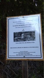
We have been going to a forest service camp on slate creek out of la Porte ca for many years and the area has been off limits to claiming in the camp area. Recently this sign was put up claiming the entire area. The camp is called american house. Anyone know these people or how we can contact them concerning the claim ? I called the forest service number and they said it is a valid claim and had no contact number.
 

Upvote 0

ratled

Hero Member
Feb 18, 2014
950
2,396
Primary Interest:
All Treasure Hunting
BLM in Sac is the folks you need to be contacting

ratled
 

Clay Diggins

Silver Member
Nov 14, 2010
4,885
14,258
The Great Southwest
Primary Interest:
Prospecting
Quick trip to Land Matters and I see the area is open to location, has six claims - 1 lode and 5 placer claims going back to 1996. The most recent claim (60 acres CAMC310759) was made in January of this year.

The Forest Service has no ability to determine if a claim is valid or not. The sign is very nice but doesn't seem to have the claim name? The people who made the claim are in error to direct people to the Forest Service "minerals staff" they can only spread more FS BS. Perhaps when you contact them you could help educate them? We don't need more ignorant miners misleading the public.

I'm sending you a PM with the locator's address'. It's public information but we don't need folks harassing these people because they have a claim. :thumbsup:

Heavy Pans
 

Last edited:

Clay Diggins

Silver Member
Nov 14, 2010
4,885
14,258
The Great Southwest
Primary Interest:
Prospecting
With a closer look I see that the area has been under claim every year but the period from 1993 - 1995!

Right now it appears to be triple overclaimed. The oldest placer claim there was located in 2005 and the "claim" on the notice has been there since 2013.

The gentlemen on the notice don't have a single claim together in that section but they probably have joined their claims together on the map they posted.

They probably got tired of visitors prospecting their claims. The visitors don't check for claims before they go. The new "Docs Place" claim didn't check before they claimed and these claimants that posted the notice appear to have failed to check before they claimed too. The oldest ACTIVE claim at that location isn't theirs. :BangHead:

Land Matters has all the tools you need to find all of this out before you put boots on the ground. It's free. More than a million people have used it. You can too. Please respect your fellow miner's claims and check before you prospect.

Heavy Pans
 

Miner49er_2015

Jr. Member
May 24, 2015
22
25
Gold Country, CA
Detector(s) used
Fisher Gold Bug Pro
Minelab Goldmonster 1000
Primary Interest:
Prospecting
Just checked the Land Matters site out, it list all the claims filed in a particular section, NE, SE, NW, SW etc.. but does not actually show a map of the claim locations. Does a person have to go to their local recorders office to find the actual claim maps? I like that you can find if there are claims in a section, that helps, but it sure would be nice if the claim locations were mapped out.
 

Clay Diggins

Silver Member
Nov 14, 2010
4,885
14,258
The Great Southwest
Primary Interest:
Prospecting
Just checked the Land Matters site out, it list all the claims filed in a particular section, NE, SE, NW, SW etc.. but does not actually show a map of the claim locations. Does a person have to go to their local recorders office to find the actual claim maps? I like that you can find if there are claims in a section, that helps, but it sure would be nice if the claim locations were mapped out.

There is no current source of claims mapping - there never has been and probably never will be. I map claims in my commercial business and there is no way to map all the claims in the United States. I can map out about 200 claims a week. There are 100s of thousands of claims in the US. The vast majority of those claims are made by metes and bounds (distance and direction) so automatically mapping claims is impossible.

You would need to visit your County Recorders records anyway. The BLM informational filing that creates the Land Matters claims map is just one of the steps needed to make a claim. If the claimant didn't make a public record of their claim at the recorders office they don't have a mining claim. You would be surprised how often people don't bother to make their required public record. One of the GPAA's most popular claims in California has never been publicly recorded. :BangHead:

Another problem you will run into is the public Location Notice record at the County Recorder's doesn't match the BLM informational filing (very common). People bend over backwards to please the BLM with multiple filings but don't make changes to their public record at the County Recorder's. Another common problem is that the BLM will enter the TRS location wrong. These errors are anywhere from a mile off to more than 800 miles in the case of some claims in South Dakota.

The BLM doesn't keep a "record" that can be legally relied on. The only true record a court will rely on is a Conformed or Certified County Recording. The BLM won't give a hoot if you commit mineral trespass or make a claim over valid location because their files were wrong. In other words just checking at the BLM does not meet your legally required "due diligence" when entering the public lands to prospect or mine.

On the Land Matters claims maps there is a layer "County Recorders" that will display the County lines and when you click the map while in information (i) mode provides a link to that County Recorder's office and another link to their file search if they have one. More and more Counties are making their records a direct download from their site - often for free.

The tools are there. It's much easier now to do the research than it was in 1872 but the requirement to do that research has not changed. Be happy you didn't try this 35 years ago. I used to spend way too much time pulling records from the County stacks or going blind trying to read microfiche in a busy office. Even so I had it a lot easier that miners 35 years before that.

Enjoy the tools at Land Matters. They give you the best start ever available for doing claims research online and they are getting better all the time. We make it as easy as possible and we will continue to try to make it easier but you will always have to do your own research to back up what you learn there. :thumbsup:

Heavy Pans
 

Last edited:

Reed Lukens

Silver Member
Jan 1, 2013
2,653
5,418
Congres, AZ/ former California Outlawed Gold Miner
Detector(s) used
Tesoro Vaquero, Whites MXT, Vsat, GMT, 5900Di Pro, Minelab GPX 5000, GPXtreme, 2200SD, Excalibur 1000!
Primary Interest:
All Treasure Hunting
View attachment 1173312

We have been going to a forest service camp on slate creek out of la Porte ca for many years and the area has been off limits to claiming in the camp area. Recently this sign was put up claiming the entire area. The camp is called american house. Anyone know these people or how we can contact them concerning the claim ? I called the forest service number and they said it is a valid claim and had no contact number.

Lot's of problems down there over the years. The Goldhounds claimed the area around the campground to keep it open to the public but a few others try to keep saying that it belongs to them. There are active claims all over the area and if you haven't been to BLM to do the research of where exactly it is that you are going, then you really should make the trip and then contact those people. I saw that sign last year but it didn't slow me down in the location we were in.
 

Top Member Reactions

Users who are viewing this thread

Top