Free USGS Topo Maps

Au-N-Rod

Jr. Member
Mar 5, 2015
46
44
Texas
Primary Interest:
Prospecting
While getting 6 inches of rain today at the house, I came across this map site. It is just about every USGS map that has been made. And you can download for free. Played for hours.


The USGS Store - One stop shop for all your maps, world, United States, state, wall decor, historic, planetary, topographic, trail, hiking, foreign, satellite, digital


It is really interesting the differences in topo maps from 30 or so years apart.


Rodney
 

Last edited:
Upvote 0

roadrunner

Bronze Member
Jan 28, 2012
1,230
520
Pinal Mountains,Arizona
Detector(s) used
Garrett Groundhog-2012-1st MD.
White's Goldmaster V/Sat-2nd-MD-2013
Tesoro Lobo-2015-3rd
Primary Interest:
Prospecting
Thanks for posting, a lot of us use that also.
 

goldenIrishman

Silver Member
Feb 28, 2013
3,465
6,152
Golden Valley Arid-Zona
Detector(s) used
Fisher / Gold Bug AND the MK-VII eyeballs
Primary Interest:
Other
Welcome to the asylum Au-N-Rod.

I'm old friends with the USGS site. I've downloaded a few gig worth of maps just for the County I live and mine in. Remember to check out some of the old maps too! through the years they've changed some of the features shown. Older maps may show mine locations that the new ones don't. I've also grabbed some of the 1:100,000 scale maps for over views of larger areas.

Because they're in PDF format, you can go into them and make notes, highlight areas and customize them in a lot of different ways. Just save them under a different name so you've always got a "clean copy". Usually I use the map name followed by MU for mark up.
 

russau

Gold Member
May 29, 2005
7,280
6,739
St. Louis, missouri
a few years back I had over 400 USGS topo maps from all over the USA. I kept the ones from my home state and offered the rest of them to clubs in the other states for FREE and couldn't find anyone that wanted them! they hit the trash!
 

CApicker

Full Member
Nov 3, 2013
153
260
West Sacramento, CA
Primary Interest:
All Treasure Hunting
I love Caltopo. CalTopo - Backcountry Mapping Evolved
Get in there and start adding layers and use the slider to go blend layers...
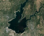
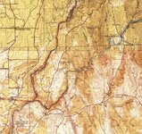
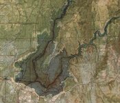
Here is an example of Folsom Lake where 1 map layer is a current satellite image, the other is a map from 1915-1945 and a blended image of both together.
Folsom lake1.JPG Folsom Lake2.JPG Folsom Lake3.JPG
 

Top Member Reactions

Users who are viewing this thread

Top