Is there gold on the OTHER side of the mountain?

gold chick

Full Member
Dec 28, 2019
106
176
Texas Gulf Coast
Detector(s) used
Garrett AT Pro
Primary Interest:
Metal Detecting
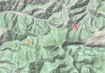
I have a question. I have found a location with multiple lodes on ONE side of the mountain, along with a huge placer discovery at the bottom of the mountain. This side of the mountain is all claimed up.

The other accessible side of the mountain has only two gold claims, lots of land left unclaimed on public property.

What do you think are the odds of finding gold on this other side of the mountain? Is it worth prospecting with a metal detector? Or not?

The X on my map is the general lode locations and the ? is for the area I am considering prospecting.

TIA!
baldy-mountain.JPG
 

Upvote 0
OP
OP
gold chick

gold chick

Full Member
Dec 28, 2019
106
176
Texas Gulf Coast
Detector(s) used
Garrett AT Pro
Primary Interest:
Metal Detecting
Just remember that the claim location map on Land
Matters shows a partition of ground that has a claim within it...an important distinction is that the entire area shaded in not necessarily claimed. You have to go to the County Recorders office and view their claim location notice to determine the actual limits of the claims. It’s just a tool to get you started.

Ya know I was wondering about that, as the boxes sometimes only have one claim in them and are 20 acres (I think) big, whereas other boxes have several claims in them and are the same size.
 

OP
OP
gold chick

gold chick

Full Member
Dec 28, 2019
106
176
Texas Gulf Coast
Detector(s) used
Garrett AT Pro
Primary Interest:
Metal Detecting
I use landmatters but it's hard to use on an android phone and my signal sucks here.

I like your off grid living website. We've been off grid for 10+ years now and still learning! It's been an awesome life change tho.

Landmatters can be tricky to work with, even on a computer. I wish they had a landmatters layer available on Google Maps, that would be killer.

Ah, I am glad you enjoyed my website! It's a never-ending learning process, I have come to find out.
 

Reed Lukens

Silver Member
Jan 1, 2013
2,653
5,418
Congres, AZ/ former California Outlawed Gold Miner
Detector(s) used
Tesoro Vaquero, Whites MXT, Vsat, GMT, 5900Di Pro, Minelab GPX 5000, GPXtreme, 2200SD, Excalibur 1000!
Primary Interest:
All Treasure Hunting
Landmatters is a great tool, just get familiar with it. Then go to the county recorder website for where you're looking and download the claim location pdfs for the section that you want. Land matters tells you how many claims are in the section, then shows the info on them as well. But to pull up the locators actual drawing, you need to go to the county recorders website, which also shows you all of the current files needed.
 

Johnnybravo300

Bronze Member
Jan 3, 2016
2,365
2,857
South of Gunnison, Gold Basin
Detector(s) used
F2
Primary Interest:
Prospecting
Yep landmatters is an awesome site, even with an android phone although harder than using a laptop.
Once I get my cell booster set up I can bluetooth to my laptop and life will be easier.
One thing i really like is being able to do my quick research on landmatters then cross reference with the lr2000. They usually match up perfect.
Landmatters is much more user friendly and a plethora of info, more than I usually need to use.

To answer the question, there can definitely be gold on both sides of the mountain.
 

OP
OP
gold chick

gold chick

Full Member
Dec 28, 2019
106
176
Texas Gulf Coast
Detector(s) used
Garrett AT Pro
Primary Interest:
Metal Detecting
Landmatters is a great tool, just get familiar with it. Then go to the county recorder website for where you're looking and download the claim location pdfs for the section that you want. Land matters tells you how many claims are in the section, then shows the info on them as well. But to pull up the locators actual drawing, you need to go to the county recorders website, which also shows you all of the current files needed.

I suppose it varies from state to state, but it looks like I am going to have to pay for the documents, just to even view them. Its five bucks an hour, or 50 a month for unlimited use. I will pay to use the service. Does your county recorder give you the info? Or is it free?

Maybe I am not looking in the right area? I have searched all over the site but the only actual docs I can find are thru iDoc, which is the pay to play. Don't wanna shell out the clams if I don't have to.

http://www.madisoncountymt.gov/
 

Last edited:
OP
OP
gold chick

gold chick

Full Member
Dec 28, 2019
106
176
Texas Gulf Coast
Detector(s) used
Garrett AT Pro
Primary Interest:
Metal Detecting
As an interesting bit of trivia....Your mountain is less than 50 miles from Confederate gulch and the Montana Bar, the location of the richest gold discover in Montana. Individual pans showed values of over $1000 each

Too bad confederate gulch is under canyon ferry lake now lol, but people still find gold on the Missouri River.
 

Reed Lukens

Silver Member
Jan 1, 2013
2,653
5,418
Congres, AZ/ former California Outlawed Gold Miner
Detector(s) used
Tesoro Vaquero, Whites MXT, Vsat, GMT, 5900Di Pro, Minelab GPX 5000, GPXtreme, 2200SD, Excalibur 1000!
Primary Interest:
All Treasure Hunting
So does the county recorder provide a map or coordinates? I'm really excited cuz I know there's spots that I thought were claimed up but only had one claim on them which means there is open land! Yay!

The recorder has the actual claim filing paperwork, maps and all.
 

Gambrinus

Sr. Member
Dec 25, 2015
313
479
Primary Interest:
All Treasure Hunting
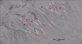
When you are researching the area I would be on the lookout for maps or descriptions of the trend of the veins. When looking at this map I would go either to the northwest or the southeast from the known mine. I am not saying this is the only place I would look but this is better than just throwing a dart at a map.

Map.jpg
 

IMAUDIGGER

Silver Member
Mar 16, 2016
3,400
5,194
Primary Interest:
All Treasure Hunting
I suppose it varies from state to state, but it looks like I am going to have to pay for the documents, just to even view them. Its five bucks an hour, or 50 a month for unlimited use. I will pay to use the service. Does your county recorder give you the info? Or is it free?

Maybe I am not looking in the right area? I have searched all over the site but the only actual docs I can find are thru iDoc, which is the pay to play. Don't wanna shell out the clams if I don't have to.

Madison County, MT | Official Website

It should be free to view the records in person..
 

Clay Diggins

Silver Member
Nov 14, 2010
4,885
14,258
The Great Southwest
Primary Interest:
Prospecting
I suppose it varies from state to state, but it looks like I am going to have to pay for the documents, just to even view them. Its five bucks an hour, or 50 a month for unlimited use. I will pay to use the service. Does your county recorder give you the info? Or is it free?

Maybe I am not looking in the right area? I have searched all over the site but the only actual docs I can find are thru iDoc, which is the pay to play. Don't wanna shell out the clams if I don't have to.

Madison County, MT | Official Website

Some states and counties are more expensive than others. Often that's based on budgets. Some of the less populated counties really can't afford to provide internet access
In Arizona virtually all county public records are available online for free.
Many counties have gone to a third party pay system like Madison County Montana. Most of those private for profit pay companies are actually different names for the same company.
In some counties in California people sell their children into slavery so they can afford a copy of a publicly recorded document. (That's internet fact)

$50 a month is an unreasonably high cost in my experience. Most counties that charge are closer to $25 per year.

Heavy Pans
 

Clay Diggins

Silver Member
Nov 14, 2010
4,885
14,258
The Great Southwest
Primary Interest:
Prospecting
Landmatters can be tricky to work with, even on a computer. I wish they had a landmatters layer available on Google Maps, that would be killer.

Land Matters doesn't work anything like Google maps. If you try to use it like Google maps you will be wasting a lot of time. There is a button on the map with instructions on how to use the map and get quick results easily. Or you could just watch one of the uTube videos on how to get best results. :thumbsup:

Simple:


Advanced:


Heavy Pans
 

Goldwasher

Gold Member
May 26, 2009
6,077
13,225
Sailor Flat, Ca.
🥇 Banner finds
1
Detector(s) used
SDC2300, Gold Bug 2 Burlap, fish oil, .35 gallons of water per minute.
Primary Interest:
All Treasure Hunting
Some states and counties are more expensive than others. Often that's based on budgets. Some of the less populated counties really can't afford to provide internet access
In Arizona virtually all county public records are available online for free.
Many counties have gone to a third party pay system like Madison County Montana. Most of those private for profit pay companies are actually different names for the same company.
In some counties in California people sell their children into slavery so they can afford a copy of a publicly recorded document. (That's internet fact)

$50 a month is an unreasonably high cost in my experience. Most counties that charge are closer to $25 per year.

Heavy Pans

Where is this slave market located.. I'm at the recorder often... maybe this will help!!
 

Goldwasher

Gold Member
May 26, 2009
6,077
13,225
Sailor Flat, Ca.
🥇 Banner finds
1
Detector(s) used
SDC2300, Gold Bug 2 Burlap, fish oil, .35 gallons of water per minute.
Primary Interest:
All Treasure Hunting
Ya know I was wondering about that, as the boxes sometimes only have one claim in them and are 20 acres (I think) big, whereas other boxes have several claims in them and are the same size.

Each of those squares is a Section of land. Typically 640 acres. Depending on Claim type and description there can/will be up several dozen claims in a section.

Have you looked into any prospecting groups in Montana?

https://centralmontanaprospectors.org/ https://www.facebook.com/groups/153584407994262
https://www.goldrushnuggets.com/goprclstdi.html Beartooth Treasure Hunters & Prospectors

Knowing if your on a claim or if an area is claimed is very important. However worrying about it can and should be off of your list for your initial prospecting experiences.
There is a learning curve in all aspects of the activity. Seek out experience and you will do much better faster than gaining it just heading out and trying on your own.
 

Goldwasher

Gold Member
May 26, 2009
6,077
13,225
Sailor Flat, Ca.
🥇 Banner finds
1
Detector(s) used
SDC2300, Gold Bug 2 Burlap, fish oil, .35 gallons of water per minute.
Primary Interest:
All Treasure Hunting
Barry , as you know My Land matter's is far superior to ANYTHING that is available . I (in my younger years) collected over 400 topo maps from around the U.S.A. by one means or another . After wearing out my ole body I started to want to share what I had learned and my equipment with club member's . I had no use for all these topo maps anymore because I couldn't get out much. SOOO I contacted clubs from all over and wanted to donate the topo's for their state to them BUT they turned my offer down saying they get this info on their smart phone's .........I even offered to donate my maps & books to our library and they turned me down also... Now me not needing them I put them into the trash . Your site is the best thing that any prospector / miner could ask for along with your expert advice ! A SALUTE to you !


ill take those maps off your hands
 

OP
OP
gold chick

gold chick

Full Member
Dec 28, 2019
106
176
Texas Gulf Coast
Detector(s) used
Garrett AT Pro
Primary Interest:
Metal Detecting
Some states and counties are more expensive than others. Often that's based on budgets. Some of the less populated counties really can't afford to provide internet access
In Arizona virtually all county public records are available online for free.
Many counties have gone to a third party pay system like Madison County Montana. Most of those private for profit pay companies are actually different names for the same company.
In some counties in California people sell their children into slavery so they can afford a copy of a publicly recorded document. (That's internet fact)

$50 a month is an unreasonably high cost in my experience. Most counties that charge are closer to $25 per year.

Heavy Pans

Yeah, I agree with you, 50 bucks a month is high! That is for unlimited access, so I suppose I could get all my research ready and hit the recorder hard for a month. I am going to try the 5 bucks for an hour and see how much work I can get done within that hour.

Montana has more cows than people and doesn't charge sales tax so we end up paying in different ways (vehicle registration, property taxes, etc.) so I don't particularly mind paying for the service if I have to.

Poor kids, I bet they were the bad ones lol
 

OP
OP
gold chick

gold chick

Full Member
Dec 28, 2019
106
176
Texas Gulf Coast
Detector(s) used
Garrett AT Pro
Primary Interest:
Metal Detecting
When you are researching the area I would be on the lookout for maps or descriptions of the trend of the veins. When looking at this map I would go either to the northwest or the southeast from the known mine. I am not saying this is the only place I would look but this is better than just throwing a dart at a map.

View attachment 1790925

Yes, I think this method would be more effective than banking on gold on the other side of the mountain. Good suggestion.
 

OP
OP
gold chick

gold chick

Full Member
Dec 28, 2019
106
176
Texas Gulf Coast
Detector(s) used
Garrett AT Pro
Primary Interest:
Metal Detecting
Each of those squares is a Section of land. Typically 640 acres. Depending on Claim type and description there can/will be up several dozen claims in a section.

Have you looked into any prospecting groups in Montana?

https://centralmontanaprospectors.org/ https://www.facebook.com/groups/153584407994262
https://www.goldrushnuggets.com/goprclstdi.html Beartooth Treasure Hunters & Prospectors

Knowing if your on a claim or if an area is claimed is very important. However worrying about it can and should be off of your list for your initial prospecting experiences.
There is a learning curve in all aspects of the activity. Seek out experience and you will do much better faster than gaining it just heading out and trying on your own.

OK that is good to know. Looks like I need to get better at using the tools I have, it is a huge learning curve just learning where to prospect, then checking for claims, then using the equipment properly, let alone having the time to do it all.

I've been into prospecting and rockhounding for a long time, but I haven't had that much time and resources to pursue it - until now. I am trying to do all the preemptive work I can before going into expedition mode.

I will look into some local groups, being that MT is so sparsely populated and vast, it can be hard to connect with other prospectors, but its worth a shot.
 

OP
OP
gold chick

gold chick

Full Member
Dec 28, 2019
106
176
Texas Gulf Coast
Detector(s) used
Garrett AT Pro
Primary Interest:
Metal Detecting
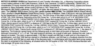
Alright, so I paid the five bucks to get access to claim locales just to see, this is what I got in return:

Lindsay Gold.JPG

No fancy map or coordinates, just a paragraph of the markers (could be a post or tree stump) in some sort of quadrangle, with a shape (rectangle, parallelogram, square) and roughly how big it is. Ugh.

I guess I am starting to feel frustrated. I suppose I need to stumble around the forest and find old tree stumps and posts with a half ripped off sheet of paper telling me its claimed. I can figure out the quadrangle (I think that's what its called) on the cadastral (which I use to locate the public land) but the rest, I dunno.

I did find some closed claims, however.

If I can locate the discovery point of the claim, I can use measuring tools to figure out the boundary.

UPDATE: Ok I found a Section Township Range coordinate converter and I located the point of discovery. So now I can use that to draw out the footage in the shape that they describe. I guess I can make it work!

After all this work, I will be placing my own dang claim if I find a good spot. Sheesh!

Another question: Is the point of discovery always the southwest corner? If so, I can get the Section Township Range from the BLM report
 

Last edited:

Reed Lukens

Silver Member
Jan 1, 2013
2,653
5,418
Congres, AZ/ former California Outlawed Gold Miner
Detector(s) used
Tesoro Vaquero, Whites MXT, Vsat, GMT, 5900Di Pro, Minelab GPX 5000, GPXtreme, 2200SD, Excalibur 1000!
Primary Interest:
All Treasure Hunting
You need to look back farther at the recorder. That is simply the quit claim deed from when he bought the claim. You need to go back to the notice of location of mining claim to see the maps drawn by the person who filed the claim in the first place.
But all of the coordinates are there, so you can easily draw your own map of the claim. But it is a current valid claim that belongs to someone else. Time to put your boots on 8-)
Download the map pdf, print out the section on standard paper so you have the topo, then add in the posts yourself.
Here's the pdf page
https://madisoncountymt.gov/243/Quadrangle-Topographic-Maps
 

Last edited:

Top Member Reactions

Users who are viewing this thread

Top