The Frenchman
Newbie
- Oct 29, 2014
- 4
- 13
- Primary Interest:
- All Treasure Hunting
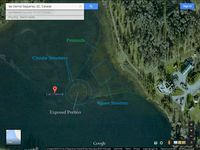
Possible Location of the Treasure
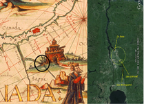
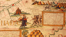
When Jacques Cartier, on his second voyage in 1535 to what is now the province of Quebec, when visiting the inlet of what is now called the Saguenay river, he was told by the two sons of the native chief, Donnacona, that there was a kingdom that existed of blond haired white men in the place they called Saguenay. These white men bore valuable jewels and possessed great material wealth.
It is said that the name Saguenay comes from the Iroquois word “Saki nip” meaning “where water flows out”, yet there is no hard proof of the origin of the name, while most native names for areas in North America have solid proof as to their origins. It is possible that the name Saguenay was not native in origin, but rather a variation of the name provided by the white people they were speaking of. The words “Sa Gagne” translates “it won”, or “did win”. In a poem by Wolfram von Eschenbach in the year 1210, when he corrects the original author of the grail story, Chretien of Troyes, he uses the words “Did win” to describe obtaining the grail. Sa Gagne and Saguenay are almost identical in pronunciation.
If these people of Saguenay did in fact exist at some point in time, one would think that they would be of Viking heritage, but if so, why did they leave no trace of their existence behind them? The only explanation would be that they did not want future settlers to know they had been there and were perhaps living there as fugitives.
No proof of mining by pre-Columbian European settlers exists in the region, so if they did in fact exist, where did all their gold and silver treasures, which Donnacona spoke of, come from?
Donnacona, with such a high position of leader of the Stradacona, was not likely to be insane or making this story up. The story would have been passed on through oral tradition. It is difficult to believe a story about people with real European characteristics could have been invented considering the people of the area would have had no exposure to white people otherwise, and it would have been just as likely that they would have claimed that they were blue or green, had they been making the story up.
Since Viking settlements in North America in pre-Columbian times were left there, rather than covered up, it is doubtful that these were Vikings and more likely to be people living in somewhat secrecy, such as fugitives.
Donnacona was taken to France, where he shared tales of the “Golden Kingdom of Saguenay”” with the King of France, and continued to profess of its once existence until he died of scurvy 1539.
Due to unusually cold temperatures of 1307, when the Templars are suspected to have set sail with treasures from the port of La Rochelle, the Templars would have likely taken the Canary Current southward (this would be the same time that numerous visits by European sailors began to be made to the Canary Islands) and continued along the North Equatorial Current towards North America. They then likely followed the Gulf Stream up the coast of North America where they finally entered the St. Lawrence inlet where the Labrador Current intersects with the Gulf Stream, making it very difficult to travel further north.
While in what is now the Quebec region of Saguenay, they may have hidden the treasure to keep it away from the Europeans who had knowledge of it, at which time they were witnessed by the local natives of the area. They likely did not stay long enough to build permanent lodgings, and likely did not want to leave a trace of their visit there, in order to secure the safety of the hidden treasure.
The Templars were then likely to continue along the what becomes the North Atlantic Current from the Gulf Stream towards the U.K., specifically Scotland. In the Rosslyn Chapel of the Templar family of Sinclair, there are depictions of fauna which would only be found in North America, such as Aloe and Maize, which is likely evidence that the Templars had indeed visited North America, since the carvings are pre-Columbian in date.
Curiously enough, the late Billionaire Paul Desmarais, who was born in Sudbury, Ontario and for the most part, built his business out of Montreal, purchased a large parcel of land and built his famous estate close to the entrance of the Saguenay River in the area of Sagard, Quebec (I encourage you to look it up on the internet... it has the appearance of a royal French palace). The surname of Desmarais comes from the royal bloodline of Baldwin I of Jerusalem, who’s family (DesMarets which later became Desmarais) ruled Jerusalem during the occupation of the crusades. I can only speculate that Mr. Desmarais chose this location due to its beauty and seclusion, but perhaps there exists a connection that we are unaware of. Paul Desmarais was highly, and I mean HIGHLY influential in both Canadian and global politics (aside from being close to all Canadian prime ministers, he was a very close friend of Nicolas Sarkozy and many other major players in global power).
Another connection might be in the names of the lakes along the Saguenay River. For instance, on the southern side of the river exists a lake by the name of Lac Clairval (location 48.295937, -71.172936). Val is the French word for valley or dale and can also be worded as Vaux, this is the same name as Bernard de Clairvaux. Perhaps this is a clue to where the treasure is buried.
Hope this helps.


