??? on peralta stone maps???

K

Keifer

Guest
boulder dash

I have wondered about that myself. The most reasonable explaination I have ever ran across for the largest hole is one I read that was written by Jim Hatt who is one of the leading authorities on the stone maps, but even he isn't sure and only calls it a theory. I will include his explaination of what he thinks it is for below.

If you have ever read anything he has written about the stone maps, you already know that his perspective on them is a lot different than anyone elses, but he introduces some thought provoking possibilities worthy of consideration.

k
 

Attachments

  • dot.jpg
    dot.jpg
    83.1 KB · Views: 741
OP
OP
B

boulder dash

Jr. Member
Aug 28, 2006
35
8
It seems many people believe the holes are ment for mountain peaks. I personally think thay are for somthing else. that large hole is not much of a mountain and the other one to the east that is supposed to be picket post mountain is on the rong side of queen creek wash. The holes mean somthing else maybee a mine shaft or somthing.
 

K

Keifer

Guest
I have also heard that some people believe they are mtn pks. I agree with you, doesn't seem to be to well thought out. The one thing Jim said that sticks in my mind, is that they took the chance of breaking the stone to get that hole in there. Same thing goes for the smaller holes and for the heart cavity in the other map stone. Those cut outs had to have been mighty important to whoever made those maps to risk breaking the stones to get them in there.
 

Zeitgeist_Xero

Jr. Member
Jun 5, 2006
27
8
Maybe its for a peg; as if it were a sun dial? It might point to something at a certain time of day, etc.
Just a guess...
 

Seventytwo

Jr. Member
Apr 4, 2005
71
2
Arizona
Detector(s) used
Many
Zeitgeist_Xero said:
Maybe its for a peg; as if it were a sun dial? It might point to something at a certain time of day, etc.
Just a guess...
Ted De Grazia signed some of his paintings with the "time of day" next to his signature. This is signature is very present in his book "A Man and his Mountain the Superstition". This could very well be his way of saying that he made these stones.
Seventytwo?
 

Carl995

Hero Member
Apr 5, 2015
665
1,359
Primary Interest:
All Treasure Hunting
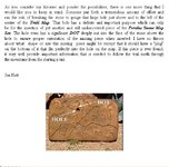
Was wondering if anyone new what those round holes in the peralta stones were used for or what they mean?There are quite a few on the heart stone and one on the trail stone.


It could be a mounting hole for a brace to hold a scriber or Dremel tool?
 

somehiker

Silver Member
May 1, 2007
4,365
6,426
Primary Interest:
All Treasure Hunting
Not likely, since such a hole would be required on both surfaces of all three stones.
I had once proposed that it could be a pivot hole for an alidade,....having used one in the past....https://c2.staticflickr.com/8/7141/6673177729_2419377fac_b.jpg
I can't imagine that being the case however, if Travis merely copied part of the "ground map" on to the two trail stones.
If he did ? ...maybe he drilled or dremeled the hole, so that he would have somewhere to put his finger when telling his friends his "stories".
 

Last edited:

deducer

Bronze Member
Jan 7, 2014
2,281
4,360
Primary Interest:
Other
Or maybe he just wanted to be able to hang it up on the coat rack stand when he wasn't busy with it.
 

somehiker

Silver Member
May 1, 2007
4,365
6,426
Primary Interest:
All Treasure Hunting
Or maybe he just wanted to be able to hang it up on the coat rack stand when he wasn't busy with it.

Mounted on a wall, with a peg in that hole, you could hang a coat on it.
And pegs in the holes of the other trail stone would give you somewhere to hang your hat, scarf and mittens.
So now you know the truth....absolutely brilliant, he was.

All along, I was hoping it signified a cave of relatively shallow depth, with a smaller tunnel at the rear being indicated by the small hole above......but reality....
 

Last edited:

deducer

Bronze Member
Jan 7, 2014
2,281
4,360
Primary Interest:
Other
Mounted on a wall, with a peg in that hole, you could hang a coat on it.
And pegs in the holes of the other trail stone would give you somewhere to hang your hat, scarf and mittens.
So now you know the truth....absolutely brilliant, he was.

All along, I was hoping it signified a cave of relatively shallow depth, with a smaller tunnel at the rear being indicated by the small hole above......but reality....

Don't forget the hole below the F. Reckon that was for his keychain, eh?
 

Azquester

Bronze Member
Dec 15, 2006
1,736
2,596
Primary Interest:
All Treasure Hunting
All holes, rectangles, squares, "U" shapes whether upside down or rightside up, are considered a doorway into another canyon or space, open air or not.

At least in real Spanish Treasure Maps.

In Travis's case the hole was used for a wooden peg as a door stop when he used the stone maps as floor tile in his carving shack.
 

sgtfda

Bronze Member
Feb 5, 2004
2,351
3,887
Mesa Arizona
If you guys paid close attention to the Legend show you would have seen exactly what that hole is on the map. There was more than one location on that show! Now that it's cooling off Wayne and I will be visiting some of those sites. Things were found by both of us.
 

Last edited:

somehiker

Silver Member
May 1, 2007
4,365
6,426
Primary Interest:
All Treasure Hunting
If you guys paid close attention to the Legend show you would have seen exactly what that hole is on the map. There was more than one location on that show! Now that it's cooling off Wayne and I will be visiting some of those sites. Things were found by both of us.


Musta missed it Frank.
The only map with a hole in it, was the stone map in the museum segment of the Legend show.
Didn't have a peg in it, but more than a few have hung their hat on those trail stones over the years.
 

Last edited:

Carl995

Hero Member
Apr 5, 2015
665
1,359
Primary Interest:
All Treasure Hunting
put golf tees in it and use it to tee off

So let me see if I can understand your statement.....

You place the stone at the starting point (tree with arm pointing),
use a #2 driver at 3pm in the afternoon (2=3) & the ball should land in the LDM hole avoiding all the traps shown on the stone?
 

Last edited:

deducer

Bronze Member
Jan 7, 2014
2,281
4,360
Primary Interest:
Other
So let me see if I can understand your statement.....

You place the stone at the starting point (tree with arm pointing),
use a #3 driver at 4pm in the afternoon & the ball should land in the LDM hole avoiding all the traps shown on the stone?

You got it!
 

cw0909

Silver Member
Dec 24, 2006
4,364
3,222
Primary Interest:
Other
could the holes and or dots be where the survey markers are.
ive tried to follow the convos over the yrs,as to where the
TS trail is, cant say i could map it as ive never seen an
overlay onto the TS. no idea why T.T. would have those markers
marked on the stones, just a crazy thought i had


i looked at 2 markers, does anyone think they are close
or are there any markers close to the holes and dots

info.....
PID - DU0483
1935 MONUMENTED
datasheet
DATASHEETS

LA BARGE DU1894
1946 MONUMENTED
datasheet
DATASHEETS

map scroll or coords
National Geodetic Survey Data Explorer

@link more info data can be found
National Geodetic Survey - Survey Marks and Datasheets
 

Top Member Reactions

Users who are viewing this thread

Top