Arrastras

Nov 8, 2004
14,582
11,942
Alamos,Sonora,Mexico
Primary Interest:
All Treasure Hunting
Side Thought. Bars were approx 45 Kilos each, in established camps, there were generally two to a burro or Mule for a balanced load.

45Kilos is approximately 90 lbs,

of course there were many different sized bars, such as those which were the contents of the melting flask which were merely dumped on the ground creating barsof app,5- 600 lbs, in order to defeat the Bandits - they required a cart to transport them, which the bandits did not have.
 

Old

Hero Member
Feb 25, 2015
656
1,409
Virginia
Detector(s) used
Whites
Primary Interest:
All Treasure Hunting
Deducer, before we get into a "did too, did not" match, I think we are talking about two different time periods, two different outcomes. I'm talking 1700's to mid 1800's.

The Hohokam did have canal systems which, I believe, contributed to the water ways running dry. Could it have contributed to their abrupt departure???? Don't know, but its something to ponder. Certainly could have if there was a sustained dry period. After their departure, over time, the river returned to its normal banks. And; I would say, didn't have the unnatural absorption from the sandy gravel laden desert floor areas fed by the canal systems.

Our mystery miners would have been around in this in between period when the river was contained in its normal banks.

After the 1850's the area was again populated with an agriculture based population. This population again turned to canal systems to divert the normal flow of water. And; the river responded as before leaching out into the sand and gravel based soil. It would naturally dry out faster and be subject big swings in flood and dry spells.

The dams and reservoir system masks the problem but the root issue is still there. Nothing unusual or sinister. Its just progress and the nature of the beast. We have the same issues here enhanced with miles of concrete and asphalt and wonder why we have 100 year flood plains that flood every 10 years. Go figure.
 

Hal Croves

Silver Member
Sep 25, 2010
2,659
2,695
Why not the Salt? It has a good flow, year round. An abundance of wild life for hunting. Has cut a deep trench in many of the mineralized areas doing much of the work for you. Has tributaries with known gold placers. Has flat bar areas with wide expanses for viewing incoming unwanted attention. Seems like a good staging location to me.

You just described Mormon Flat.

I just thought that it was an added step and expense, hauling ore to a common arrastra area as opposed to constructing one onsite or at the closest spring. I think that arrastras, located on the Salt, have more to do with what you described as a staging location. A protected and accessible working area.

There are maps that tell us exactly where to look if they can be read properly. Find one using a map and that would be big.
 

deducer

Bronze Member
Jan 7, 2014
2,281
4,360
Primary Interest:
Other
Deducer, before we get into a "did too, did not" match, I think we are talking about two different time periods, two different outcomes. I'm talking 1700's to mid 1800's.

The Hohokam did have canal systems which, I believe, contributed to the water ways running dry. Could it have contributed to their abrupt departure???? Don't know, but its something to ponder. Certainly could have if there was a sustained dry period. After their departure, over time, the river returned to its normal banks. And; I would say, didn't have the unnatural absorption from the sandy gravel laden desert floor areas fed by the canal systems.

Our mystery miners would have been around in this in between period when the river was contained in its normal banks.

After the 1850's the area was again populated with an agriculture based population. This population again turned to canal systems to divert the normal flow of water. And; the river responded as before leaching out into the sand and gravel based soil. It would naturally dry out faster and be subject big swings in flood and dry spells.

The dams and reservoir system masks the problem but the root issue is still there. Nothing unusual or sinister. Its just progress and the nature of the beast. We have the same issues here enhanced with miles of concrete and asphalt and wonder why we have 100 year flood plains that flood every 10 years. Go figure.

Lynda, I am not interested in a pissing match. I have and always will be interested in historical accuracy as far as what happened in the Superstitions. You have shared quite a bit of knowledge here on this forum that I've benefited from. I will only beg to differ when I know otherwise or am pretty sure of something. I end up being wrong every now and then, but that's inconsequential to me. To me, someone who is right all the time, is someone who doesn't learn anything new.

The Hokoham, as far as I understand them, occupied a much larger area than the Salt and Gila River basins- their occupation extended over what is today known as the four corners region. Their civilization extended as far south as Casa Grande, so it would be difficult to consider drought as a sole driver in their extinction. What is becoming a popular sentiment is that there was a combination of factors: drought, warfare, disease, and more importantly, some form of rapid climate change that made it difficult for them to exist in large sustained, agricultural communities, and they disbanded and most of them became assimilated into the Pima and O'odham, initiating the ethnogenesis of these groups.

And as far as the Salt River, here is a good overview that talks about the summer droughts being a big factor in the decision to build a dam.
 

Old

Hero Member
Feb 25, 2015
656
1,409
Virginia
Detector(s) used
Whites
Primary Interest:
All Treasure Hunting
good morning Deducer,

Agreed, agreed! Although its a somewhat off topic discussion I find cultures and their histories fascinating. As long and windy as my writing often are, they lose much in the small points of my thoughts. That's a failing on my part.

What I'm trying to convey is there is a difference between a down stream man made problem (such as the canal water diversion) and a major catastrophe where there is such a sustained drought as would cause the mountain run off and shallow aquifers to become completely dry. If there was such a total loss of available water, over such a large area, things would start to die on a large scale and it would happen pretty quickly. Hence, my comments about the explorers would have more to worry about than running the arrastras.

I could be wrong, I often am, but don't think a total loss of flow occurred regularly in the area Hal is talking about. Downstream, yes. Fluctuations surely did happen but sustained total loss I'm betting against.

The point I was making, rather badly, is that water was the most crucial factor in where people (any people) located. The Salt river flats and tributaries (to me) were ideal places to locate what I'm calling staging areas of exploration. Water and plenty of it was crucial. What better place to get it? It just seems like a natural base of operations to me.

Some of this is gleamed from historic record of where people (native and otherwise) located and some is pure speculation on my part. But; hard headed as I am, I don't think that speculation is far fetched. If there is any merit to my thoughts, we can estimate how far inland large groups of prospectors would be able to safely venture from that base to explore. Distance to known perennial sources would give us route and general areas. Certainly not foolproof but a general overlay of probable and less probable target areas.
 

OP
OP
E

EarnieP

Hero Member
Jul 20, 2015
526
1,062
Primary Interest:
All Treasure Hunting
..."I could be wrong, I often am,"...

Old, I think the only thing you're wrong about is that statement. :)

But if you were to ever make a mistake on this site it'd be like 'breaking wind in an echo chamber', you'd never hear the end of it! (To paraphrase Click and Clack the Tappet Brothers.):laughing7:
 

deducer

Bronze Member
Jan 7, 2014
2,281
4,360
Primary Interest:
Other
The point I was making, rather badly, is that water was the most crucial factor in where people (any people) located. The Salt river flats and tributaries (to me) were ideal places to locate what I'm calling staging areas of exploration. Water and plenty of it was crucial. What better place to get it? It just seems like a natural base of operations to me.

Some of this is gleamed from historic record of where people (native and otherwise) located and some is pure speculation on my part. But; hard headed as I am, I don't think that speculation is far fetched. If there is any merit to my thoughts, we can estimate how far inland large groups of prospectors would be able to safely venture from that base to explore. Distance to known perennial sources would give us route and general areas. Certainly not foolproof but a general overlay of probable and less probable target areas.

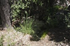
You'd be surprised at how many water sources inside the Superstitions were actually just as reliable, if not more than the Salt River. For example, the below picture is one of the "hidden" pools that is part of Charlebois Spring. I was surprised to see how deep it was- around 4 feet, and heavily guarded by shade as you can see, so it would easily last year round. This is just around the corner from Marsh Valley, long suspected to be heavily settled by Mexicans during their forays into the mountains.

Charlebois.jpg

And as far as arrastres, water would have been helpful, but not strictly necessary to work one.
 

Hal Croves

Silver Member
Sep 25, 2010
2,659
2,695
You'd be surprised at how many water sources inside the Superstitions were actually just as reliable, if not more than the Salt River. For example, the below picture is one of the "hidden" pools that is part of Charlebois Spring. I was surprised to see how deep it was- around 4 feet, and heavily guarded by shade as you can see, so it would easily last year round. This is just around the corner from Marsh Valley, long suspected to be heavily settled by Mexicans during their forays into the mountains.

View attachment 1304038

And as far as arrastres, water would have been helpful, but not strictly necessary to work one.

Was crushed ore panned before smelting or, was the dust of the work panned?
 

gollum

Gold Member
Jan 2, 2006
6,729
7,596
Arizona Vagrant
Detector(s) used
Minelab SD2200D (Modded)/ Whites GMT 24k / Fisher FX-3 / Fisher Gold Bug II / Fisher Gemini / Schiebel MIMID / Falcon MD-20
Primary Interest:
All Treasure Hunting
The crushed ore was just rough smelted into dore bars. No refining was done in the field. At the end of the mining season, they would pull up all the floor stones of the arrastra. They dug all the dirt to about two or three feet, and panned that. The reason is that as they crushed ore from late Summer until the following late Spring, fine gold gets pushed into the cracks between the floor stones and pushed down. Like I stated in my other post, my friends that found the intact arrastra North of Apache Lake got about $17,000 from the two or so feet of dirt under it's floor stones they panned.

While using an arastra, there are mainly two ways to get the gold;

1. Just crush the ore as fine as possible in the arrastra and pan everything.

2. Crush the ore, amalgamate all the noble metals with Mercury, cook off the mercury, and smelt the rest into dore.

Mike
 

Hal Croves

Silver Member
Sep 25, 2010
2,659
2,695
The crushed ore was just rough smelted into dore bars. No refining was done in the field. At the end of the mining season, they would pull up all the floor stones of the arrastra. They dug all the dirt to about two or three feet, and panned that. The reason is that as they crushed ore from late Summer until the following late Spring, fine gold gets pushed into the cracks between the floor stones and pushed down. Like I stated in my other post, my friends that found the intact arrastra North of Apache Lake got about $17,000 from the two or so feet of dirt under it's floor stones they panned.

While using an arastra, there are mainly two ways to get the gold;

1. Just crush the ore as fine as possible in the arrastra and pan everything.

2. Crush the ore, amalgamate all the noble metals with Mercury, cook off the mercury, and smelt the rest into dore.

Mike

Much appreciated.

So, finding an intact arrastra with gold suggests that those working it departed quickly?
And an intact arrastra with no gold would suggest an orderly departure, the floor stones being replaced.
 

deducer

Bronze Member
Jan 7, 2014
2,281
4,360
Primary Interest:
Other
Sorry for the dumb question. How do you get the ore under the huge rocks? I know it spins but why don't they (huge rocks) just push the ore ahead or to the side? I am dumb that way.

The rough surface of the arrastre floor and of the rocks themselves is what traps the ore and breaks them up, bit by bit, rather than pushing them aside.
 

Azquester

Bronze Member
Dec 15, 2006
1,736
2,596
Primary Interest:
All Treasure Hunting
You just described Mormon Flat.

I just thought that it was an added step and expense, hauling ore to a common arrastra area as opposed to constructing one onsite or at the closest spring. I think that arrastras, located on the Salt, have more to do with what you described as a staging location. A protected and accessible working area.

There are maps that tell us exactly where to look if they can be read properly. Find one using a map and that would be big.


Hal, newer Arastra's used by anglo's incorporated the easy dump access on the side. The earlier ones used by the Spanish would have been the Patio Process which required a large flat area for drying the Arrastra made "Cake". The cake was tested with salt and made ready for the patio process where as the cake was squeezed through cloth bags with Mercury added. Then it was cooked and the Mercury recovered for the next bags.
 

audigger53

Hero Member
Mar 27, 2004
909
3,210
Severn, Maryland
Detector(s) used
None
Primary Interest:
Cache Hunting
It is quite possible that the Southern Hokoham had the same problem as the Pimas. The Pimas were the "Jewel of the Indian Affairs until the mineral deposits built up to the top soil and just about killed the farming there in the early 50's. Hundreds of years of irrigation and the salt built up. The Gila was the first river dammed in Arizona, that was when Calvin Coolidge was President. When it flooded it would cut the state in half, North South.
 

Hal Croves

Silver Member
Sep 25, 2010
2,659
2,695
Hal, newer Arastra's used by anglo's incorporated the easy dump access on the side. The earlier ones used by the Spanish would have been the Patio Process which required a large flat area for drying the Arrastra made "Cake". The cake was tested with salt and made ready for the patio process where as the cake was squeezed through cloth bags with Mercury added. Then it was cooked and the Mercury recovered for the next bags.

There must have been some type of crushing/pounding device located at each at each of these sites and the material fed into the arrastra already pre-crushed?
 

Nov 8, 2004
14,582
11,942
Alamos,Sonora,Mexico
Primary Interest:
All Treasure Hunting
Hal,The Spanish used a slightly off set wood attachnent / fastening in order to raise the leading edge of the drag stone many drag stones used the natural overhang However, the ore was reduced by hammers first
 

Last edited:

Hal Croves

Silver Member
Sep 25, 2010
2,659
2,695
Hal, that line would make a fantastic opening sentence (two actually) to the book many of us believe you should write.

A book? Doubtful. But, if I could produce one historically accurate map of the area, more detailed than any before, I feel that I could justify the my time here.


Top Member Reactions

Users who are viewing this thread

Top