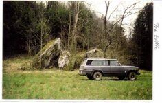
Tea Kettle rock has 4 maps and 11 names. if you look close behind the rock, you will see another rock resting on the edge of the hill, this is the key rock that gives the direction to go, which is 330 degrees to find the rockhouse and the mine on the second ledge, it also as a marker pointing down at tea kettle showing which map to use to go to the rockhouse and mine. Tea kettle is shaped like a tea kettle.
Tea Kettle 1762, 1764, 1766
- Thread starter boomer
- Start date


Top Member Reactions
-
 2272
2272 -
 1114
1114 -
 1029
1029 -
 911
911 -
 861
861 -
 767
767 -
 752
752 -
 736
736 -
 608
608 -
 493
493 -
 493
493 -
 483
483 -
 421
421 -
O
420
-
 419
419 -
 406
406 -
 403
403 -
 392
392 -
 379
379 -
 371
371

