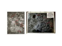
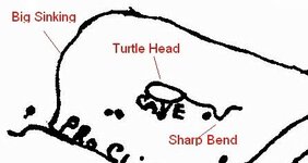
When Mike Steely put this up something clicked. those of you near lee county should check this out. the 2 carvings one at henry bowlin gap and the other at big sinking creek lee county. the lower devils creek map and the 2 carvings were done by the same group. the map was never of lower devils creek, but of beattyville ky. and sinking creek. i have 3 other carvings that i felt was arrow heads, but now i know were bird beaks pointing the way.
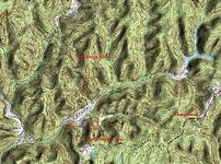
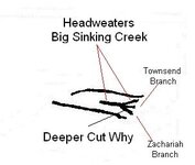
From bolin gap north to the rockcastle river. follow river upstream to indian fork, go up fork to mckee ky. this was a buffalo cross roads. go east to war fork. then north to kentucky river. cut across to big sinking creek, up to cave fork. cave fork is the key to all this. if you read insert on carving, it says turkey tracks. i wonder if the turkey tracks or other carvings on that rock point to other important areas?? below the 2 carvings are the same. note the deeper lines cut in some parts. the right side is the main trail or big sinking creek. the deep circles are 2 high points on ridges to the northeast. note the
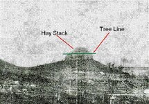
gray lines i put in, zooming in i saw cut lines on the neck. 2 drains facing each other. right side of body, a drain flowing into big sinking. lower part of neck, seems to show big sinking going up and stopping near the chiseled out area. the left rear leg is deep cut, so is the right rear. not sure why? numbers 4 and 5, 4 looks 2 be a square area. 5 is a ridge shaped like an arrow head. on topo map it shows 2 side by side as on the carving. below, look at the small secton of lower devils creek map and the topo map, it shows the same area, cave fork and the bird beck is the same place. the open area. there is a high dome knob next to the open area that is called hay stack rock. on the carving left side of the head its also deep cut. go to the head waters of big sinking creek and there are 3 forks that come together forming a turkey track has on the lower devils creek map and its outlined meaning vary importent. ahh if my foot was healed. check out that rock with all the carvings. there has to be more.
From bolin gap north to the rockcastle river. follow river upstream to indian fork, go up fork to mckee ky. this was a buffalo cross roads. go east to war fork. then north to kentucky river. cut across to big sinking creek, up to cave fork. cave fork is the key to all this. if you read insert on carving, it says turkey tracks. i wonder if the turkey tracks or other carvings on that rock point to other important areas?? below the 2 carvings are the same. note the deeper lines cut in some parts. the right side is the main trail or big sinking creek. the deep circles are 2 high points on ridges to the northeast. note the
gray lines i put in, zooming in i saw cut lines on the neck. 2 drains facing each other. right side of body, a drain flowing into big sinking. lower part of neck, seems to show big sinking going up and stopping near the chiseled out area. the left rear leg is deep cut, so is the right rear. not sure why? numbers 4 and 5, 4 looks 2 be a square area. 5 is a ridge shaped like an arrow head. on topo map it shows 2 side by side as on the carving. below, look at the small secton of lower devils creek map and the topo map, it shows the same area, cave fork and the bird beck is the same place. the open area. there is a high dome knob next to the open area that is called hay stack rock. on the carving left side of the head its also deep cut. go to the head waters of big sinking creek and there are 3 forks that come together forming a turkey track has on the lower devils creek map and its outlined meaning vary importent. ahh if my foot was healed. check out that rock with all the carvings. there has to be more.


.png")


